
Eacuation Restrictions Lifted for Areas Impacted by the Diamond Fire
Related Incident:
Publication Type: Announcement
Sunflower, Cross F and Diamond Ranch - 08/01 11:00 AM -- return to READY status. Please continue to use caution and follow public safety instructions.
More Info at https://www.fs.usda.gov/alerts/tonto/alerts-notices/...
Closures
Related Incident:
Publication Type: Closures
Fire Closures - North Cascades National Park (U.S. National Park Service) (nps.gov)
Closures: Trail and camp closures remain in effect due to fire activity. Closure information can be found at https://www.nps.gov/noca/planyourvisit/fire-closures.htm . Access across Diablo Dam is limited to Skagit Tours, Ross Lake Resort, and North Cascades Environmental Learning Center reservation holders only
Gorge Lake Campground is closed due the proximity of the Sourdough Fire and for firefighter and visitor safety.
Little Bear Fire Daily Update August 1 2023
Related Incident:
Publication Type: Announcement
"Percent completion” of objectives more accurately captures and reports the specific amount of work accomplished on the ground to manage fire spread and reduce the negative impacts to communities, infrastructure, and other identified values. By using percent completion of objectives, fire managers can illustrate how they are progressing with the accomplishment of objectives that have been identified and prioritized. As a comparison, “containment” implies firelines around the entire perimeter, directly next to the fire's active edge.
Noticias matutinas para el Incendio Flat 1 de Agosto 2023
Related Incident: Flat Fire
Publication Type: News
1 de Agosto, 2023
Noticias matutinas para el Incendio Flat
Fecha de Inicio: 15-Julio-23
Extension: 27,573
Origen: 2 millas al Sureste de Agness, OR
Contencion: 14%
Causa: Error humano, Bajo investigación
Personal : 1,547
Recursos: 52 camiones de bomberos l 35 escuadrillas de bomberos l 2 buldóceres l 25 cisternas l 4 maquinas masticadoras l 9 helicopteros
Situacion Actual: El dia de ayer, en la esquina Suroeste del Incendio, los bomberos utilizaron el Sistema Aereo Automatizado (UAS/drones) para igniciones aereas con el fin de incrementar la quema en aproximadamente unos 200 pies hacia el interior de la linea de fuego.
Aunado a este trabajo, los helicopteros se apoyaron con el uso de un Dispensador Esferico de Plastico (PSD) en las operaciones mas internas del incendio, logrando mover la principal de este, a partir del Suroeste hacia las lineas de fuego. Esta estrategia logra movilizar los incendios principales hacia las lineas preparadas de fuego que se encuentran bajo condiciones mas favorables y controladas.
El consumo de la materia de combustion varia segun el mosaico de la vegetacion sobre el terreno (hierba y madera). Se completo una operacion de quema a lo largo de la linea de buldocer hacia el Este y desde la zona de Game Lake con aproximadamente 150 pies de profundidad en el interior de esta y hacia el area mas importante que aun no se habia quemado.
Los recursos de bomberos para la proteccion de la infraestructura continuan buscando casas de habitacion adicionales y edificios que aun no han sido identificados, colectando esos datos para asi informar a los bomberos en caso de que surja la necesidad de proteger dichas viviendas.
Para el dia de hoy, se planea finalizar la linea de control alternativa sobre la carretera Forestal (FSR) 3313, 1502 y 3680.
Anoche, se llevo a cabo una reunion para la comunidad en Brookings-Harbor y tambien fue transmitida en vivo en Facebook. La grabacion del evento esta disponible en : https://fb.watch/m8b1R2JtRk/ .
Actividades para el dia de hoy: Se estarán usando recursos aéreos para lograr penetrar líneas adicionales de fuego localizadas entre las porciones Oeste y Este de la FSR 3680 exactamente en la esquina Suroeste del incendio. También, se iniciará una quema aérea dentro del interior del área de Game Lake. Dentro del trabajo arduo que conlleva la preparación de las líneas de incendio, el día de hoy comenzara la eliminación de material de combustión proveniente de la vegetación que ha sido cortada a lo largo de las líneas de contención al Oeste de la zona. La línea de contención que se extiende desde Wildhorse Lookout al Este de la FSR 3577, esta siendo limpiada completamente y patrullada por nuestros bomberos. La esquina Noreste del Incendio, utilizando la carretera Forestal FSR 2308 y 150, ha sido preparada para las operaciones de incendio en caso de que se presente la necesidad debido a los cambios abruptos del clima y/o la actividad en el incendio.
Con el incremento en el tráfico sobre la carretera Bear Camp Road, se hace un llamado a los motoristas que manejen a baja velocidad, con mucha precaución y con las luces delanteras de su vehículo encendidas.
Se han desmovilizado los recursos que ya no son necesarios en los esfuerzos de supresión del incendio. Estamos muy agradecidos de su trabajo profesional y por favor descansen y estén preparados para asignaciones de trabajo futuras en lo que resta de la temporada de incendios.
Evacuaciones: A partir del día de ayer, todos los niveles de evacuación restantes han sido reducidos a un Nivel 1 “Prepárese” para todas las áreas en las proximidades del Incendio Flat.
La Oficina del Alguacil para la ciudad de Curry continuara coordinándose con el Grupo para el Manejo de Incidente de Incendio y serán los responsables de notificar a los residentes afectados por el incendio acerca de las razones para cambiar los niveles de evacuación.
La ciudad de Curry está enviando noticias de evacuación utilizando el sistema Everbridge. Usted puede registrarse en: https://www.co.curry.or.us/departments/emergency_management/index.php
Condiciones climáticas: Para el día de hoy, el pronóstico del tiempo está avisando un ligero incremento en la temperatura (hasta 3-5 grados) y baja humedad relativa (menor de 3-5%). Durante el día, existe un potencial de experimentar el día más caliente durante el incendio Flat.
Impacto del humo: Pronósticos en la presencia del humo, puede encontrarse en la página web: https://outlooks.airfire.org/outlook/en/b74901f7
Cierres de áreas: El Bosque Nacional de Rogue River-Siskiyou, emitió una nueva orden de cierre el día 29 de Julio para ciertas áreas incluyendo senderos, carreteras y parte del rio Illinois. Esta orden de cierre abarca Oak Flat Campground, Game Lake Campground, Wildhorse Campground y el Lookout Recreacional de Snow Camp. La carretera forestal de Chetco River
Road (FR 1376) y la de Chetco/Pistol River Road (FR 1407) actualmente se encuentran cerradas. Esta nueva orden de cierre permitirá al público el acceso a el área para nadar de Big Rock en el Rio Illinois.
Puede encontrar información actualizada:https://tinyurl.com/bdzbae69
Orden de restricción: Se han establecido Restricciones en el área. Para mayor información: fs.usda.gov/rogue-siskiyou
Las condiciones varían para el material de combustión en el área, presentándose materia seca en algunas zonas mientras que en otras todavía se puede observar la vegetación fresca. Las condiciones climáticas calurosas y secas continúan representando un peligro alto para el incendio.
Por favor siga las restricciones en el incendio y utilice supresores de chispas que estén funcionando apropiadamente y permanezca en senderos y caminos designados. No se parquee, descanse o maneje sobre vegetación inflamable. Su vehículo podría iniciar un incendio forestal.
Blum Fire Daily Update August 1 2023
Related Incident: Blum Fire
Publication Type: News
Blum Fire Update
Tuesday August 1, 2023
Size: est. 300 acres
Containment: 97%
Start Date: July 26, 2023
Cause: Under Investigation
The Blum Fire started on July 26, 2023, and was initially responded to by multiple local and county entities. Texas A&M Forest Service was requested to assist at 3:15 p.m. and responded with aviation resources, heavy equipment and engines from Texas A&M Forest Service and Texas Intrastate Fire Mutual Aid System (TIFMAS). Multiple departments from Hill, Johnson and Bosque counties are working in unified command with Texas A&M Forest Service and Texas Division of Emergency Management (TDEM).
Yesterday: Crews continued to engage in mop up operations across the fire area, checking for hotspots or smoke.
Today: Crews will patrol the perimeter of the fire and interior roadways, checking for hotspots and smoke and perform mop up as needed. If there are no unexpected changes in the fire conditions, the incident commander anticipates accomplishing 100% containment at the end of shift today. The remaining resources on the fire will be available to respond to any new wildfire activity if it occurs.
Weather and Fire Behavior: RED FLAG WARNING IN EFFECT FROM 1 PM THIS AFTERNOON TO 1 AM WEDNESDAY. Excessive heat warning is in effect until 8 pm this evening. Hot and dry conditions will persist through Wednesday with highs near 108 today and minimum humidity around 20%. South winds around 10 mph will continue. RH recovery is expected to be around 65% tonight. No precipitation is expected. With the increased potential to wildfire due to the hot, dry, and windy conditions, residents should avoid outdoor activities that may cause a spark, including welding, grinding and using heavy machinery.
Evacuations: There are currently no evacuations in place.
Damages/Injuries: One outbuilding was confirmed to be destroyed by the fire. No homes have been destroyed by the fire. No injuries have been reported at this time.
Closures: There are currently no closures in place.
Fire Information
Information Officer
Texas A&M Forest Service
Email: information@tfs.tamu.edu
Phone: 979-255-0591
Inciweb: https://inciweb.wildfire.gov/incident-information/txtxs-blum-fire
Facebook: https://www.facebook.com/AllHazardsTFS
Twitter: https://twitter.com/AllHazardsTFS
Settings - change map background and toggle additional layers
Filter - control incident types displayed on map.
Zoom to your location
Reset map zoom and position
Could not determine your location.
Show Legend
 Wildfire
 Prescribed Fire
 Burned Area
Response
Burned Area
Response Other
Other
Powder Keg Pine Fire
Unit Information
Incident Contacts
Area Road and Trail Closures
Related Incident:
Publication Type: Closures
Order Number: # 23-009-Lolo-D6
U.S. Department of Agriculture, U.S. Forest Service
Flathead National Forest
Swan Lake Ranger District
Lolo National Forest
Seeley Lake Ranger District
Area, Road & Trail Closures
PROHIBITIONS
Pursuant to 16 U.S.C. § 551 and 36 C.F.R. § 261.50(a & b), the following is prohibited on the National Forest System (NFS) lands, roads, trails in the Swan Lake and Seeley Lake Ranger Districts of the Flathead National Forest and Lolo National Forest, described below and shown on the attached map incorporated into this Order as Exhibit A (Colt Fire Closure):
1. 36 C.F.R. § 261.53(e). It is prohibited to go into the area or be upon any road or trail closed for the protection of: Public health or safety.
EXEMPTIONS
Pursuant to 36 C.F.R. § 261.50(e), the following persons are exempt from this Order:
1. Persons with Forest Service Permit No. FS-7700-48 (Permit for Use of Roads, Trails, or Areas Restricted by Regulation or Order), specifically exempting them from this Order or a written determination by a Forest Service authorized officer that a permit is not required under 36 C.F.R. § 251.50(e)(1) or (2).
2. Any Federal, State, or Local Officer, or member of an organized rescue or firefighting resource in the performance of an official duty.
DESCRIBED AREA/ROADS/TRAILS
CLOSED AREA: All National Forest System (NFS) areas enclosed within the following boundary are closed to public use effective immediately. Starting at the northernmost point of the area closure: All NFS lands south and west of the intersection of National Forest System Road (NFSR) #906 (Beaver Creek Rd) and MT HWY 83 (T19N, R16W, Sect. 22). Following to the south west, adjacent to MT HWY 83 S, and west of Rainy Lake and Lake Alva to the junction of NFSR 552 (West Fork Clearwater) NFSR 646 (Colt Creek) (T18N, R16W, Sect. 24). Continuing east along the north side of NFSR 552 to the junction with MT Hwy 83, follow MT HWY 83 S to the southern limit of (T18N, R15W, Sect. 7), near Boy Scout Road, including Lake Inez camp Ground Continuing due west to the border of Montana Fish Wildlife & Park’s Marshall Creek Wildlife Management Area (T17N, R15W, Sect. 7), include all NFS lands north and west of described locations to the Lolo National Forest boundary with the south-westernmost boundary of Montana Fish Wildlife & Park’s Marshall Creek Wildlife Management Area (T17N, R17W, Sect.24). Follow Lolo NF boundary along the Mission Mountains Wilderness to the junction with Beaver Creek stream bed (T18N, R17W, Sect. 11). Continue northeast along Beaver Creek stream bed to where Beaver Creek intersects with NFSR #906 (T19N, R16W, Sect. 22). As shown on the ATTACHED MAP.
CLOSED ROADS: All roads within the closure area boundary including but not limited to: National Forest System Road (NFSR) #906, NFSR #646, NFSR #4356, NFSR #4354, NFSR #1099
CLOSED TRAILS: Forest System Trail 34 (Jocko Trail) is closed from the Jocko Trailhead at Lindbergh Lake to the intersection of Forest System Trails 351 and 35. Forest System Trail 35 is closed from the intersection of Forest System Trail 34 to the Crystal Lake South Trailhead.
PURPOSE
The purpose of this order is for public health and safety due to hazardous conditions resulting from fire activities.
IMPLEMENTATION
1. This Order will be in effect on July 24 at 00:01 hours (12:01 am) and shall remain in effect until October 31st, 2023, or until rescinded, whichever comes first.
2. A map identifying the Described Area is attached and made part of this Order as Exhibit A. For a digital version of this Order and Exhibit A, go to https://www.fs.usda.gov/alerts/flathead/alerts-notices https://www.fs.usda.gov/detail/lolo/alerts-notices/?cid=stelprdb5351897
3. Unless otherwise expressly defined in this Order, the terms used in this Order are defined by the regulations of the Secretary of Agriculture, 36 C.F.R. Chapter II, Parts 200-299. If there are terms in this Order that are not expressly defined in the Order or 36 C.F.R. Chapter II, Parts 200-299, their meaning shall be determined by their plain language definitions.
4. A violation of the above prohibitions is punishable as a Class B misdemeanor by a fine of not more than $5,000 for individuals and $10,000 for organizations, or by imprisonment for not more than six months, or both. 16 U.S.C. § 551; 18 U.S.C. §§ 3559, 3571, and 3581.
5. Contact the Lolo National Forest Supervisor’s Office in Missoula, MT, (406) 329-3750, or the Flathead National Forest Supervisor’s Office in Kalispell, MT, (406) 758-5208, for more information about this Order. 6. This Order supersedes any previous Orders prohibiting the same or similar acts in the same Described Area.
Signed and issued on 8/18/2023
Carol Hatfield
Forest Supervisor
Flathead National Forest
Carolyn Upton
Forest Supervisor
Lolo National Forest
Settings - change map background and toggle additional layers
Filter - control incident types displayed on map.
Zoom to your location
Reset map zoom and position
Could not determine your location.
Show Legend
- Wildfire
- Prescribed Fire
- Burned Area
Response
- Other
West Hallett
Unit Information
Incident Contacts
August 1 Daily Update
Related Incident: Eagle Bluff
Publication Type: News
At 6 a.m. today, Northwest Incident Management Team 7 took command of the Eagle Bluff Fire from Northeast Washington Incident Management Team 2.
First reported on Saturday, July 29, the Eagle Bluff Fire has grown to 15,349 acres with yesterday’s growth occurring mostly on the western flank. The fire is burning in steep and rugged terrain in northern Okanogan County. The cause remains under investigation by the Washington Department of Natural Resources.
Crews have confirmed the loss of four structures.
Fire management objectives include limiting the fire’s size and duration while accounting for public and firefighter safety and protecting values at risk. Those values include human safety, private property, cultural and natural resources, utilities, and other critical infrastructure.
The fire is burning just west of Oroville, Wash. on lands managed by the Washington Department of Natural Resources and the Spokane District – Bureau of Land Management and has crossed into Canada.
More than 400 personnel are assigned to the fire. Firefighting efforts today will focus on continued mop-up and cold trailing around structures and along the eastern flank near Oroville and Highway 97. Crews continue building containment lines on the western flank to keep the fire east of the Loomis-Oroville Road and prevent further western spread. Ongoing coordination with the British Columbia Wildfire Service will seek to tie in firefighting efforts on both sides of the border.
A dry air front with lower humidity coupled with frequent gusts and shifting wind directions may lead to instances of active fire spread today. Uphill runs in light, flashy fuels and spotting up to a quarter mile in timbered areas are possible. An overnight inversion is expected to push smoke into the Okanogan Valley.
Evacuation levels have decreased in Okanogan County, but some road closures remain in place. For up-to-date information on wildfire closures and evacuations, follow Okanogan County Emergency Management at https://okanogancounty.org/government/emergency_management/
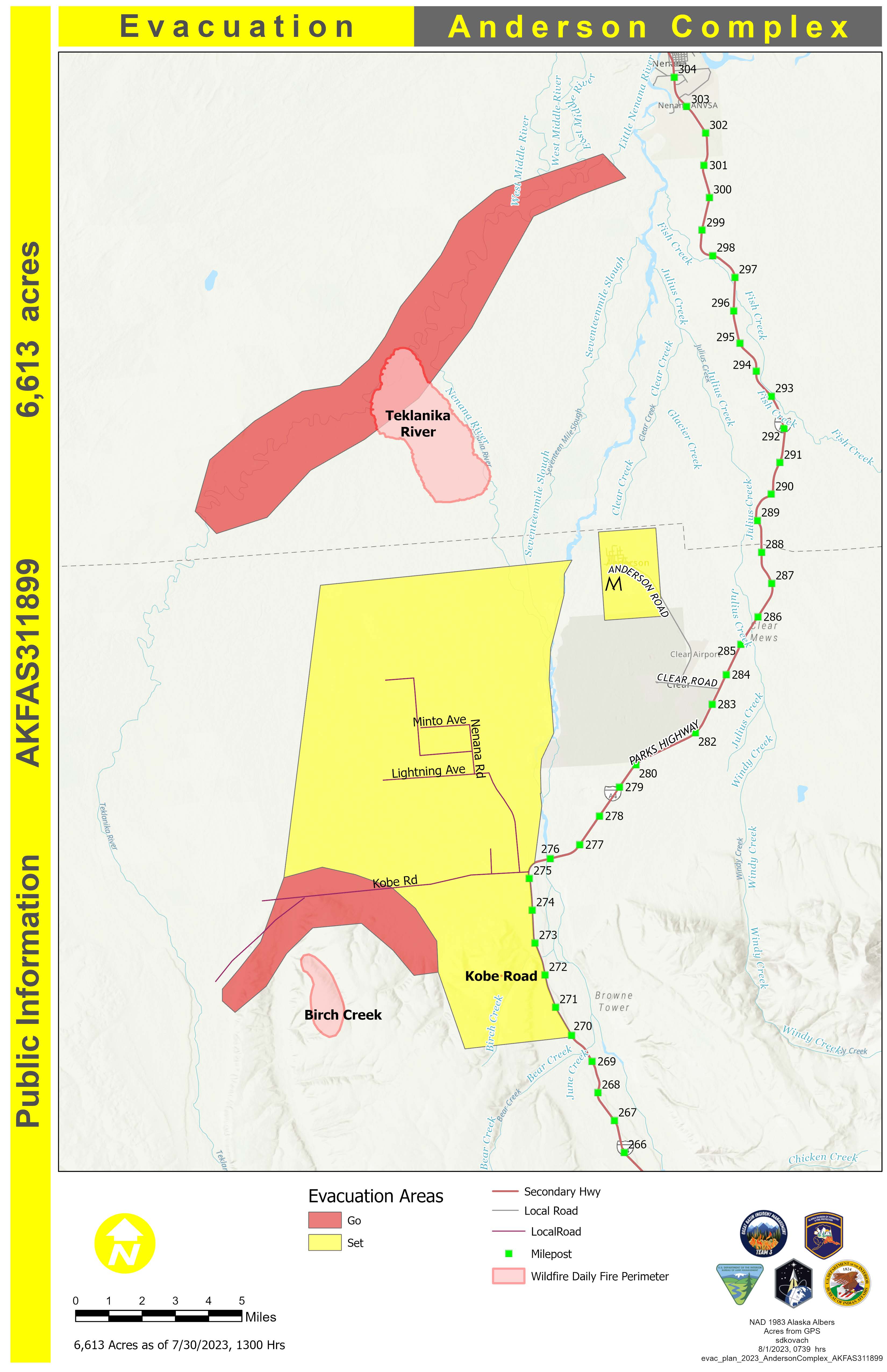
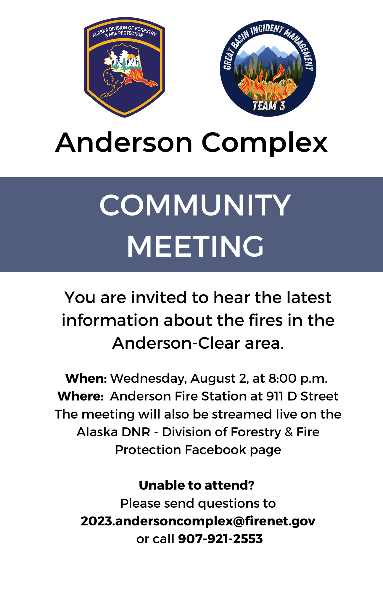
Anderson Complex Daily Update for August 01 2023
Related Incident: Anderson Complex
Publication Type: News
Anderson Complex crews expect to see increased fire activity
Warmer, dryer weather is forecast for the Anderson Complex area beginning today. Fire activity is expected to increase. In advance of this change in the weather, firefighters have spent the past several days working to protect structures along the Teklanika River; find and extinguish spot fires along the river; assess and improve fire breaks around the city of Anderson; and identify and assess structures in the Kobe Ag subdivision, Clear Sky subdivision, and Rose Hip Creek area.
This work will continue today, with additional resources arriving to join the fight.
The Midnight Sun and Lassen hotshots continue to protect structures from the Teklanika River Fire (#257) and snuff out spot fires along the river. The Joint Base Elmendorf-Richardson (JBER) Task Force will be back in the city of Anderson today, inspecting fire breaks and making improvements where needed. Residents are asked to give firefighters plenty of room to work.
Firefighters aided by tracked vehicles known as skidgens will begin assessing structures in the North 40 subdivision today to implement a protection plan there. They will also scout and identify tactical options to keep the fire west of the Nenana River and protect infrastructure along the Parks Highway.
The Shasta Lake Hotshots will continue to assess structures in the area of the Birch Creek Fire (#285) to determine appropriate protection tactics. They are also working to extinguish the 0.1-acre Kobe Road Fire, which is expected to be declared out at the end of today’s shift.
The Anderson Complex includes the Teklanika River Fire (#257), Birch Creek Fire (#285), Kobe Road Fire (#297), Nenana River Fire (#288), and Nenana River Fire 2 (#289). The Nenana River and Nenana River Fire 2 are located inside the burn scar of the 2022 Clear Fire. The two fires are a combined at 0.3 acres in size with minimal activity and no growth reported.
EVACUATION STATUS: The Teklanika River and all residents along the Teklanika River, and all residents in Clear Sky homestead (not the Clear Sky Lodge) and residents adjacent to Rose Hip Creek are in Evacuation Status GO. Individuals in this area should evacuate now. Do not delay. The Tri-Valley School is available for evacuation parking and will be available as an evacuation center, if needed.
The city of Anderson and all residents that use any road west of the George Parks Highway between milepost 270 and the Rex Bridge are in Evacuation Status SET. Individuals in this area should be ready in a moment’s notice.
Visit the Denali Borough website for additional information.
CLOSURE: The Anderson Shooting Range and associated camping areas will be closed from Tuesday, Aug. 1, through Friday, Aug. 4, for firefighter and public safety. The brief closure will allow fire crews to complete work on a fuel break.
COMMUNITY MEETING: Great Basin Team 3 will hold a community meeting at
8 p.m. on Wednesday, Aug. 2, at the Anderson Fire Station, 911 D Street. Representatives from the team and cooperating agencies will provide an update on the fire and answer questions from community members. The meeting will be streamed live on the Alaska Division of Forestry and Fire Protection Facebook page for those who cannot attend in person.