
Road Restriction Order West Side South Fork Road 895
Related Incident:
Publication Type: Closures
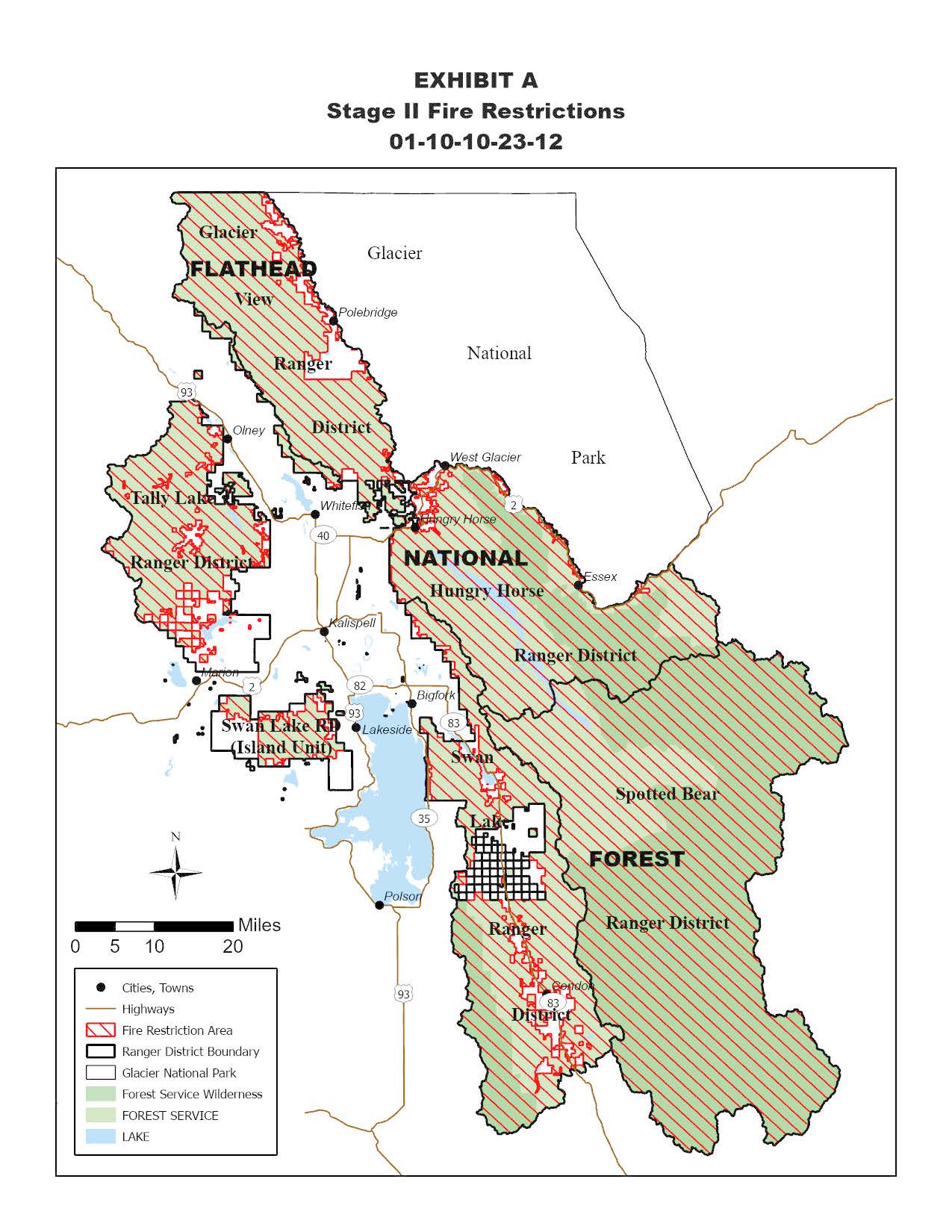
Pursuant to 16 U.S.C. § 551, 36 C.F.R. § 261.50(b), and 36 C.F.R. § 261.54(a), the following prohibitions are in effect on the Hungry Horse Ranger District on the Flathead National Forest, Flathead County, Montana as depicted on the map attached as Exhibit A and hereby incorporated into the order:
PROHIBITION
1.Title 36, CFR 261.54(a): Using any type of motorized vehicle on the roads described below and depicted on Exhibit A is prohibited.
PURPOSE
This closure is for public and construction crew safety during emergency road slump repairs near Wheeler Creek. The below listed road segment is closed to all motorized vehicular use, including over snow use during the time frames listed below.
ROAD SEGMENT CLOSED TO MOTORIZED VEHICLES
West Side South Fork Road #895 will be closed between milepost 39.1 (immediately south of its intersection with Wheeler Creek Road #895F) and milepost 39.7 (approximately 150 feet north of Wheeler Creek bridge) in Section 15, Township 27 North, Range 17 West.
Stage 2 Fire Restrictions Flathead National Forest
Related Incident:
Publication Type: Closures
The following is prohibited on the National Forest System (NFS) lands in the Flathead National Forest described below and shown on the attached map incorporated into this Order as Exhibit A (the “Described Area”):
1. Igniting, building, maintaining, attending, or using a fire. (Including fires fueled by charcoal or briquettes).
a. Exception: A device solely fueled by liquid or gas that can be turned on and off used in an area barren or cleared of all flammable materials within three feet of the device; or
b. Exception: A fully enclosed metal stove with a chimney at least five feet in length and a mesh screen spark arrestor with a screen opening of a ¼ inch or less used in an area that is barren or cleared of all flammable materials within 10 feet of the device.
2. Smoking, except in an enclosed vehicle or building, a developed recreation site, or while stopped in an area at least three feet in diameter that is barren or cleared of all flammable materials.
3. Operating or using any internal or external combustion engine without a spark arresting device properly installed, maintained and in effective working order meeting either U.S. Department of Agriculture, Forest Service Standard 5100-1a; or appropriate Society of Automotive Engineers (SAE) recommended practice J335(b) and J350(a). For chainsaw use a chemical pressurized fire extinguisher (with a minimum 8 oz. capacity and rating of 2A) must be kept with the operator, and a round point shovel with an overall length of at least 35 inches readily available for use.
a. Operating generators with an approved spark arresting device is permitted only within an enclosed vehicle or building or in an area that is barren or cleared of all overhead and surrounding flammable materials within three feet of the generator.
4. Blasting, welding, or operating acetylene or other torch with open flame, except if in a cleared area of at least 10 feet in diameter and a chemical pressurized fire extinguisher (with a minimum 8 oz. capacity and rating of Class 2A) is kept with the operator.
5. Using an explosive. This includes but is not limited to fuses, blasting caps, fireworks, rockets, exploding targets, tracers, and incendiary ammunition.
6. Possessing or using a motor vehicle off NFS roads, except when parking in an area devoid of vegetation within 10 feet of the motor vehicle.
Sourdough Fire Daily Update August 2 2023
Related Incident:
Publication Type: News
Fire Size: 30 Containment: 0%
Personnel: 132 Helicopters: 1 Single Engine Air Tanker: 0
2023.Sourdough@firenet.com
360-370-4169
https://inciweb.nwcg.gov/incident-information/warlp-sourdough-fire
The Sourdough Fire is being managed by the Southern Area Gray Incident Management Team. Mitch Ketron (Gray Team Incident Commander) assumed command of the Sourdough Fire on Tuesday, August 01, at 7:00 AM local time. Yesterday’s Activities: Fire personnel continued to scout and identify possible fire containment lines and natural features. Helicopter water drops continued as needed to slow fire spread. There was minimal fire growth. This is a no-drone zone. Unauthorized drone flights (UAS) pose serious risks to firefighter and public safety and the effectiveness of wildfire suppression operations. Aerial firefighting is suspended when unauthorized UAS are in the area, allowing wildfire to grow larger. Fire personnel are actively engaged in structure protection, triage, and preparation based on fire location and behavior.
Today
Fire personnel will continue to scout and identify possible fire containment lines. Helicopter water drops will continue in an effort to slow fire spread due to terrain-influenced roll-out. Terrain is extremely steep, rugged, and inaccessible. Motorists are urged not to pull over along State Route 20 near the Diablo Dam. While the road remains open, keep in mind your safety and those of first responders. Do not pull over to take photos or deploy drone aircraft.
Weather
Sunny, with a high near 79. Calm wind becoming west between 7 and 10 mph. Humidity: Minimum 67%
Area or Road Closures – Evacuations Trail and camp closures are in effect due to fire activity. Closure information can be found at https://www.nps.gov/noca/planyourvisit/fire-closures.htm. Access across Diablo Dam is limited to Skagit Tours, Ross Lake Resort, and North Cascades Environmental Learning Center reservation holders only. No evacuations are in effect.
2 de Agosto 2023 Matutino para el Incendio Flat
Related Incident: Flat Fire
Publication Type: News
Extension: 29,387 acres Start Date: July 15, 2023
Origen: 2 millas Sureste de Agness, OR
Contencion: 28%
Causa: Error humano
Personal: 1,419
Recursos: 39 camiones de bomberos l 31 escuadrillas de bomberos l 2 buldóceres l 24 cisternas l 4 maquinas masticadoras l 9 helicopteros.
Situacion Actual: Nuevamente, los helicopteros utilizaron igniciones aereas para profundizarse mas desde las lineas de contencion mas alla del interior del incendio que aun no se habia quemado y localizado cerca del area de Game Lake. Al mismo tiempo, se esta trabajando en la esquina Suroeste del fuego en el drenaje de Lawson Creek hacia el fuego fuera de los ejes de las cordilleras y quemando las laderas con la finalidad de poder avanzar con el trabajo hacia la contencion en esta area.
La implementacion de esta estrategia, evita que el fuego principal se propague hacia las lineas de incendio que ya se encuentran preparadas bajo condiciones mas favorables y controladas. Los bomberos dirigieron la irrigacion de los helicopteros sobre las areas en donde se incremento el calor interno hacia las lineas de contencion a lo largo de la linea Noreste (hacia el interior Norte del empalme de Indigo Creek) y a lo largo de la porcion del perimetro Este del incendio. Este trabajo arduo ayuda a mantener y a asegurar la linea de contencion existente y monitorea la propagacion del incendio en dichas areas.
El dia de ayer, las cuadrillas de bomberos localizaron y rapidamente lograron contener seis (6) espacios pequenos de fuego exactamente afuera de la carretera Forestal (FSR) 401 . En ese momento, fueron puestas a prueba las lineas de incendios por la presencia de vientos. A traves del uso del Sistema Aereo Automatizado (UAS/drones) se detecto y se dirigio a los bomberos al punto exacto del fuego permitiendo contenerlo rapidamente. Los trabajadores del turno nocturno lograron mantener y patrullar la linea de incendio.
Los recursos para la proteccion de la infraestructura continuaron escultando e identificando algunas viviendas adicionales y ciertos edificios. Estos datos recolectados, tienen el objetivo de ayudar a los bomberos en su trabajo de proteger las infraestructuras en la zona en caso de que se presente la necesidad. Los bomberos estan a punto de completar la linea de control alternativa sobre las carreteras forestales FSR 3313, 1503 y 3680.
Actividades para el dia de hoy: Los bomberos planean utilizar los recursos aéreos con el fin de ganar más terreno en las líneas de fuego adicionales situadas entre la porción Oeste y Este de la FSR 3680 en el drenaje de Lawson Creek (esquina Suroeste del incendio).
Dependiendo de las condiciones del clima y del tiempo disponible, se continuará con la quema aérea interna en la zona de Game Lake. El día de ayer se inició la eliminación del material de combustión y se continuara con esta labor el día de hoy desde la zona en donde se cortó la vegetación al preparase las líneas de incendio a lo largo de las líneas de contención Oeste. Las líneas de contención localizadas al Oeste y al Noreste, a partir del empalme de FSR 3680 y 3318 hacia Wildhorse Lookout al este de FSR 3577, se han estado limpiando y patrullando activamente. Sobre la esquina Noreste, utilizando la carretera forestal 2308 y 150, se han realizado trabajos de preparación para operaciones de incendio si se presentara la necesidad debido a los cambios en las condiciones del clima y/o la actividad incendiaria, así también como también el riesgo de que el fuego supere las evaluaciones realizadas por el sistema aéreo.
Un helicóptero de la Guardia Nacional de Oregon ha sido movilizado temporalmente a Medford y esta disponible para cualquier necesidad que merite asistencia médica, día y noche.
Se les hace un llamado a los motoristas cruzando la carretera Bear Camp Road, que manejen con cautela, a baja velocidad y con las luces delanteras del vehículo encendidas, debido al incremento de trafico por los bomberos luchando por detener el incendio.
Evacuaciones: Todos los niveles de evacuación restantes han sido reducidos a un Nivel 1 “Prepárese” para todas las áreas en las proximidades del Incendio Flat.
La Oficina del Alguacil para la ciudad de Curry continuara coordinándose con el Grupo para el Manejo de Incidente de Incendio y serán los responsables de notificar a los residentes afectados por el incendio acerca de las razones para cambiar los niveles de evacuación.
La ciudad de Curry está enviando noticias de evacuación utilizando el sistema Everbridge. Usted puede registrarse en: https://www.co.curry.or.us/departments/emergency_management/index.php
Condiciones climáticas: En el día de hoy, se espera un ligero enfriamiento en las temperaturas (de 1-3 grados menos) y una alta humedad relativa (arriba del 1-3%).
Asimismo, se espera que el miércoles presente condiciones climáticas calientes y secas. Las bajas y altas del ciclo climático que hemos estado experimentado han logrado moderar el comportamiento del incendio, pero en general, la materia de combustión continúa siendo seca. En esta semana, se espera el retorno de una masa de aire más cálida y seca.
Impacto del humo: Pronósticos en la presencia del humo, puede encontrarse en la página web: https://outlooks.airfire.org/outlook/en/b74901f7
Cierres de áreas: El Bosque Nacional de Rogue River-Siskiyou, emitió una nueva orden de cierre incluyendo senderos, carreteras y parte del rio Illinois. Esta orden de cierre abarca Oak Flat Campground, Game Lake Campground, Wildhorse Campground y el Lookout Recreacional de Snow Camp. La carretera forestal de Chetco River Road (FR 1376) y la de Chetco/Pistol River Road (FR 1407) actualmente se encuentran cerradas. Esta nueva orden de cierre permitirá al público el acceso a el área para nadar de Big Rock en el Rio Illinois.
Puede encontrar información actualizada: https://tinyurl.com/bdzbae69.
Orden de restricción: Se han establecido Restricciones en el área. Para más información: fs.usda.gov/rogue-siskiyou
Las condiciones varían para el material de combustión en el área, presentándose materia seca en algunas zonas mientras que en otras todavía se puede observar la vegetación fresca. Actualmente, las condiciones del incendio se encuentran a un nivel “Extremo” y las condiciones climáticas continúan presentándose más calientes y secas.
Por favor siga las restricciones en el incendio y utilice supresores de chispas que estén funcionando apropiadamente y permanezca en senderos y caminos designados. No se parquee, descanse o maneje sobre vegetación inflamable. Su vehículo podría iniciar un incendio forestal.
Little Bear Fire Daily Update August 2 2023
Related Incident:
Publication Type: Announcement
"Percent completion” of objectives more accurately captures and reports the specific amount of work accomplished on the ground to manage fire spread and reduce the negative impacts to communities, infrastructure, and other identified values. By using percent completion of objectives, fire managers can illustrate how they are progressing with the accomplishment of objectives that have been identified and prioritized. As a comparison, “containment” implies firelines around the entire perimeter, directly next to the fire's active edge.
Colt Fire Evacuation Update Wednesday August 2
Related Incident:
Publication Type: Announcement
???? ???? ?????????? ???????
The Missoula County Sheriff has lifted the Evacuation Order for the zones described as Rovero Flats East and Rovero Flats West. The zones are now under an Evacuation Warning. As residents return, they may see law enforcement removing the Red Order cards and replacing those with the Yellow Warning cards.
The map reflects changes to Evacuation Zones. Red is under Order, Yellow is Under Warning, and Green areas are pre-identified zones in the event the fire moves towards those areas. This pre-planning by fire managers and your Sheriff's Office helps you identify your zone and provides quicker response times if fire conditions warrant an Order or Warning to be issued.
To the south, additional zones that have been identified and are in green include: Fawn, 83 N, 83 S, Boy Scout N, and Boy Scout S.
Please be vigilant in monitoring fire information as conditions can change quickly! All Evacuation Warnings and Orders will be posted first on this page. Colt fire information can be found at https://inciweb.nwcg.gov/incident.../mtmts-colt-fire or on the Facebook page at https://www.facebook.com/profile.php?id=100095189078132
Bedrock Fire update for August 2 2023
Related Incident: Bedrock Fire
Publication Type: News
Bedrock Fire update for Wednesday, August 2, 2023
Lowell, Ore. – Bedrock Fire managers and cooperators sponsored public meetings in Lowell and Oakridge to present status updates and answer questions yesterday. About forty members of the local communities attended each meeting. A third public meeting will be held today at 6 p.m. at McKenzie High School. The meeting at Lowell was recorded and is available on the “Bedrock Fire 2023” Facebook page.
At the meetings, Operations Section Chief John Spencer explained the progress that has been made on establishing lines around the fire. Indirect lines were established using roads, ridgelines, and fire lines from previous fires. Fire managers have now identified locations for fire lines closer to the fire’s edges, along the perimeter south of the 18 road and to the east of the fire. Equipment and personnel are working on these direct lines, planning to hold the fire close to where it is currently burning.
Fire managers were successful at tactical firing operations on direct lines along the 1821 and 217 roads. Hand crews and engines are now working on mop up operations along the roads to maintain secure lines. Mop up consists of checking for hot spots from the perimeter into the black area of burned fuels to ensure that all potential reignition sources are put out. After mop up is completed, a section of the fire can be called “contained”.
Much of the northern flank of the fire has steeper ground and fewer roads, with limited opportunities for direct line. In this area, firefighters continue to establish indirect containment lines to provide secure locations where the fire’s spread can be stopped. The 1817 road has been prepared for use as an indirect line.
Many of the proposed direct lines are in areas burned by the Gales and Jones fires. Fuels are generally light in these areas, but dead trees or “snags” are common in the burns. These are hazardous to fire personnel working anywhere near or downhill of them. Many snags will need to be removed to allow for safe direct line construction.
WEATHER: Warmer and drier weather is expected today. High temperatures are expected to be in the low to mid-80s, with minimum relative humidity dropping below 30 percent. Warm weather is expected to continue through the week, with increasing cloud cover.
SAFETY: Aviation resources engaged in suppressing the fire are using local water sources. Not all of the water sources are in the fire closure. The public should be alert for helicopters or planes in the vicinity.
SMOKE: Smoke from the Bedrock Fire will continue to spread into central Oregon, causing some areas to experience “unhealthy” conditions. Smoke from the Flat Fire and other fires is also impacting many areas.
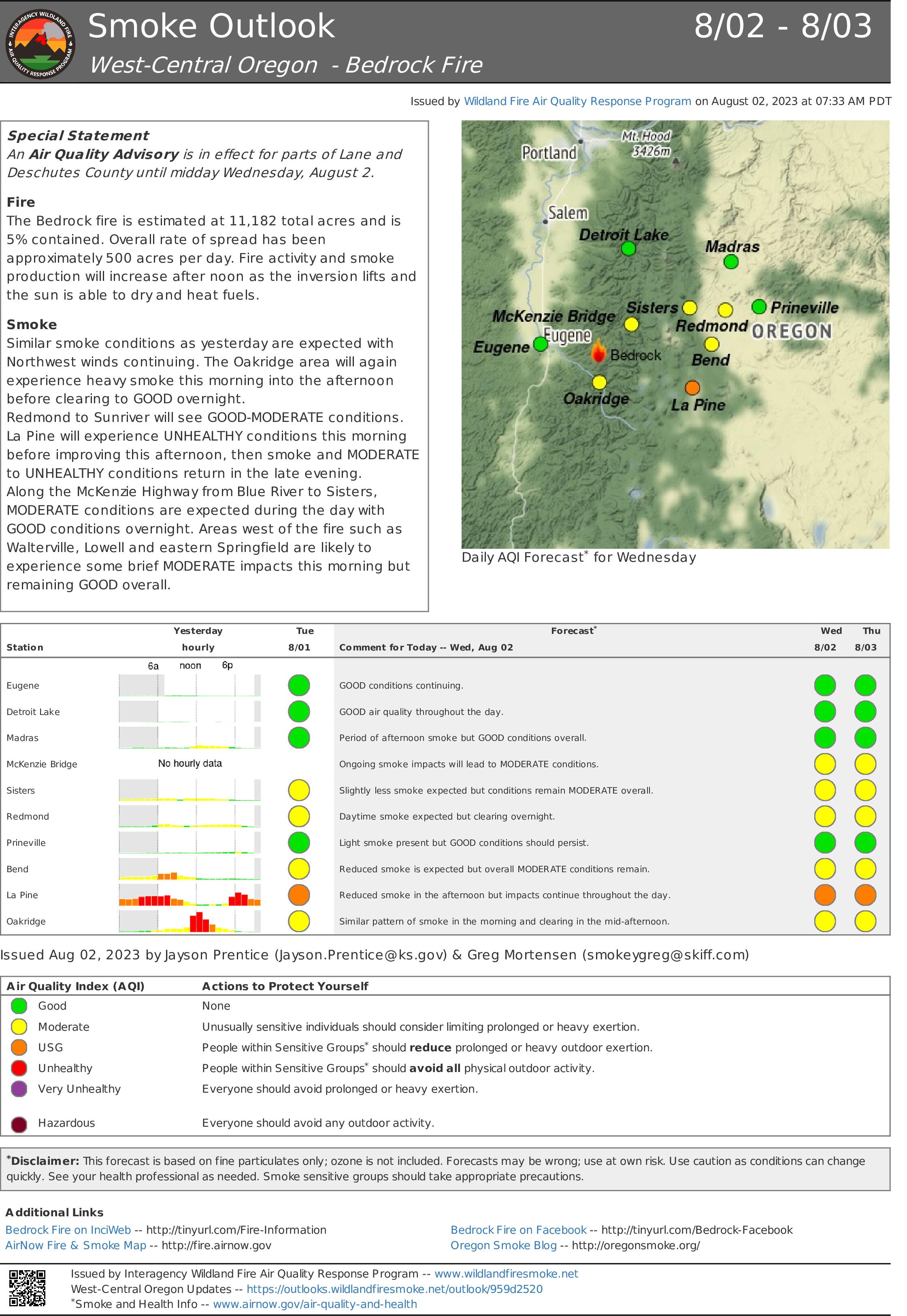
Smoke Outlook for August 2 3 2023
Related Incident: Bedrock Fire
Publication Type: News
The Bedrock fire is estimated at 11,182 total acres and 5% contained. Fire activity and smoke production will increase after noon as the inversion lifts, but overall rate of spread is anticipated to be below 1,000 acres per day.
Most should expect similar smoke conditions as yesterday with persistent weather pattern. Oakridge will see periods of heavy smoke this morning lingering into the afternoon before clearing to GOOD for evening into overnight.
An improved smoke pattern from Redmond to Sunriver will continue resulting in GOOD-MODERATE for much of the day. Expect UNHEALTHY conditions this morning in La Pine before seeing improvement this afternoon. Smoke will again settle into the area in the late evening likely resulting in MODERATE to UNHEALTHY.
MODERATE conditions are expected along the McKenzie Highway from Blue River to Sisters. Areas west of the fire such as Walterville and Lowell likely to see haze and may be MODERATE this morning before clearing this afternoon.
Blum Fire Daily Final August 2 2023
Related Incident: Blum Fire
Publication Type: News
Blum Fire Final Update
Wednesday August 2, 2023
Size: 300 acres
Containment: 100%
Start Date: July 26, 2023
Cause: Under Investigation
The Blum Fire started on July 26, 2023, and was initially responded to by multiple local and county entities. Texas A&M Forest Service was requested to assist at 3:15 p.m. and responded with aviation resources, heavy equipment and engines from Texas A&M Forest Service and Texas Intrastate Fire Mutual Aid System (TIFMAS). Multiple departments from Hill, Johnson and Bosque counties are working in unified command with Texas A&M Forest Service and Texas Division of Emergency Management (TDEM).
Yesterday: Crews were able to obtain 100% containment of the Blum Fire and have released resources to allow the resources to respond to any new wildfire activity.
Weather and Fire Behavior: RED FLAG WARNING IN EFFECT FROM 1 PM THIS AFTERNOON TO 1 AM THURSDAY. Excessive heat warning is in effect until 8 pm this evening. Hot and dry conditions will persist through Wednesday with highs near 108 today and minimum humidity around 20%. South winds around 10 mph will continue. RH recovery is expected to be around 65% tonight. No precipitation is expected.
As hot and dry conditions persist, consider the following: Always obey local burn bans and outdoor burning restrictions. Wait to conduct any outdoor burning or light campfires until the burn ban has been lifted and weather conditions improve. Nine out of 10 wildfires are human caused. When a burn ban is in place, residents should avoid outdoor activities that may cause a spark, including welding, grinding and using heavy machinery. Many areas of Texas are experiencing high temperatures and dry weather. Residents should stay up to date on weather conditions and always use extreme caution when performing outdoor activities even if not under a burn ban. Stay wildfire aware. If a wildfire is spotted, immediately contact local authorities.
Evacuations: There are currently no evacuations in place.
Damages/Injuries: One outbuilding was confirmed to be destroyed by the fire. No homes have been destroyed by the fire. No injuries have been reported at this time.
Closures: There are currently no closures in place.
Fire Information
Information Officer
Texas A&M Forest Service
Email: information@tfs.tamu.edu
Phone: 979-255-0591
Inciweb: https://inciweb.wildfire.gov/incident-information/txtxs-blum-fire
Facebook: https://www.facebook.com/AllHazardsTFS
Twitter: https://twitter.com/AllHazardsTFS
Big Knife Fire Update August 2 2023
Related Incident: Big Knife
Publication Type: News
Location: Big Knife - 5 miles east of Arlee, Montana | Niarada - 12 miles west of Elmo, Montana | Mill Pocket: 3 miles West of Highway 28 and the Niarada Fire
Start Date: Big Knife - 7/24/2023 | Niarada - 7/30/2023 | Mill Pocket – 7/30/2023
Cause: Lightning Total Personnel: 188 total Engines: 19 Aircraft: 1 + others available as needed Hand Crews: 4
Size: Big Knife - 2,000 acres, 0% contained | Niarada - 8,400 acres, 0% contained | Mill Pocket – 2000 cares, 80% contained)
Mike Behrens’ Northern Rockies Team 3 began managing the Big Knife and Niarada fires August 2, 2023, at 6:00 a.m. A community meeting for the Big Knife, Noriada, and Mill Pocket fires will be held on Thursday, August 3, 2023, at the Arlee Community Center, 34086 Pow Wow Rd. in Arlee at 6:00 PM. This meeting will be broadcast live on the CSKT Division of Fire Facebook page (www.facebook.com/CSKT.Division.of.Fire). A second community meeting will be held on Friday, August 4, 2023, in Elmo with more details to come soon.
The Big Knife Fire continued to be very active Tuesday, burning across the Big Knife drainage to the north late in the day. The fire is burning in extremely steep, inaccessible terrain for most equipment, so crews continue to try to flank the fire and help stop the spread toward the valley floor. They are aided by aircraft as conditions allow, although visibility has hindered some air operations across the multiple fires. Big Knife Fire remains visible from Missoula and throughout the Jocko Valley.
Although the Niarada Fire was also very active Tuesday, fire behavior around Niarada and Highway 28 had decreased enough to enable authorities to reopen Highway 28. The fire is burning in mixed grass and shrub fuels, helping the fire to spread quickly in hot, dry, windy conditions. Crews, heavy equipment (dozers and skideons), engines, and aerial resources continue to work the fire. They have been working to build firelines from safe anchor points and protect structures in the area. Last night, the Flathead Interagency Hot Shot Crew implemented successful strategic firing operations north of the highway to secure the line on the north perimeter nearest Lake Mary Ronan.
WEATHER AND FIRE BEHAVIOR
Hot, dry, windy weather is forecast for the coming week. Based upon current weather conditions and fire behavior trends, this weather will likely result in high potential for very active fire behavior and large fire growth.
CLOSURES AND SPECIAL MESSAGES
Stage 2 evacuations are in effect for a few residences around the Niarada Fir. Residences around both fires are under Stage 1 evacuation warnings. The Lake County Sheriff’s Office asks residents to be mindful of changing conditions and any new fire starts. Closures surrounding both fire areas are necessary to protect the safety and welfare of the public and provide for safe firefighting efforts and access. Specific closure information and maps are posted on Inciweb as they are implemented.
Use extreme caution when driving on Highway 28. Visibility is very poor and the speed limit has been reduced to 45 mph. Crews and equipment are working along the road edge and fire vehicles are present.