
Smoke Outlook August 3 2023
Related Incident: Lowline Fire
Publication Type: News
With cooler temperatures and precipitation in the area we will see MODERATE smoke early Thursday morning in Gunnison. Smoke in the area...
Snowhill Fire Daily Update August 3 2023
Related Incident:
Publication Type: News
Snowhill Fire Daily Update
August 3, 2023
6:00 am
Size: 215 acres
Containment: 90%
Start Date: August 2, 2023
Cause: Under Investigation
At 1:19 pm on Aug. 2, Texas A&M Forest Service received a request for assistance for a fire on farm to market road (FM) 946, approximately 7 miles southeast of Oakhurst, Texas.
Multiple dozers from Texas A&M Forest Service and United States Forest Service constructed containment line while 2 Type 1 helicopters and 2 super scoopers assisted with beneficial water drops to help stop forward progression and provide structure protection. Local Fire Departments continued to monitor the fire through the night. Texas A&M Forest Service and local fire departments will return this morning to enhance containment lines and conduct mop-up operations.
There is a Temporary Flight Restriction (TFR) in place for the area over the fire [NOTAM: FDC 3/7308, https://bit.ly/3OPZdBD]. Please avoid the area to provide a safe environment for firefighting aircraft.
Evacuations:
Two homes were evacuated yesterday afternoon. Residents have since been able to return.
Closures:
The road closure on FM 946 between FM3018 and Carter Road has been lifted.
Injuries:
Around 5 p.m. on August 2nd, fire behavior intensified in an area of the fire where personnel were constructing containment lines. Two Texas A&M Forest Service firefighters received first- and second-degree burns. Both injured firefighters received burns from radiant heat and were taken to a hospital for treatment.
Settings - change map background and toggle additional layers
Filter - control incident types displayed on map.
Zoom to your location
Reset map zoom and position
Could not determine your location.
Show Legend
 Wildfire
 Prescribed Fire
 Burned Area
Response
Burned Area
Response Other
Other
Mesquite Field Fire
Unit Information
Incident Contacts
Update on August 2 fire activities
Related Incident: Flat Fire
Publication Type: News
August 2, 2023: This update shares today’s progress on the Flat Fire. There will no longer be a formal evening update.
Update on Today’s Activities:
Successful work continued today on the Flat Fire with the support of helicopters and Un-crewed Aircraft Systems (UAS/drones). In the northern section of the fire, firefighters continued to mop up and improve line. Near Fantz Ranch, eight helitack firefighting crew members were inserted to do mop-up operations where Infrared detected heat to ensure that the fireline remains secure. They will be extracted tonight and plan to return to the area tomorrow to finish mopping up until that section of the fireline is completely cool. Firefighters added line depth through aerial ignitions near Game Lake, as well as further south where increasingly dry vegetation again provided good burning conditions. Crews, including Coos Forest Protective Association resources, continue to prepare road systems working toward Snow Camp to serve as alternate line.
Overview of the interior fire from the West
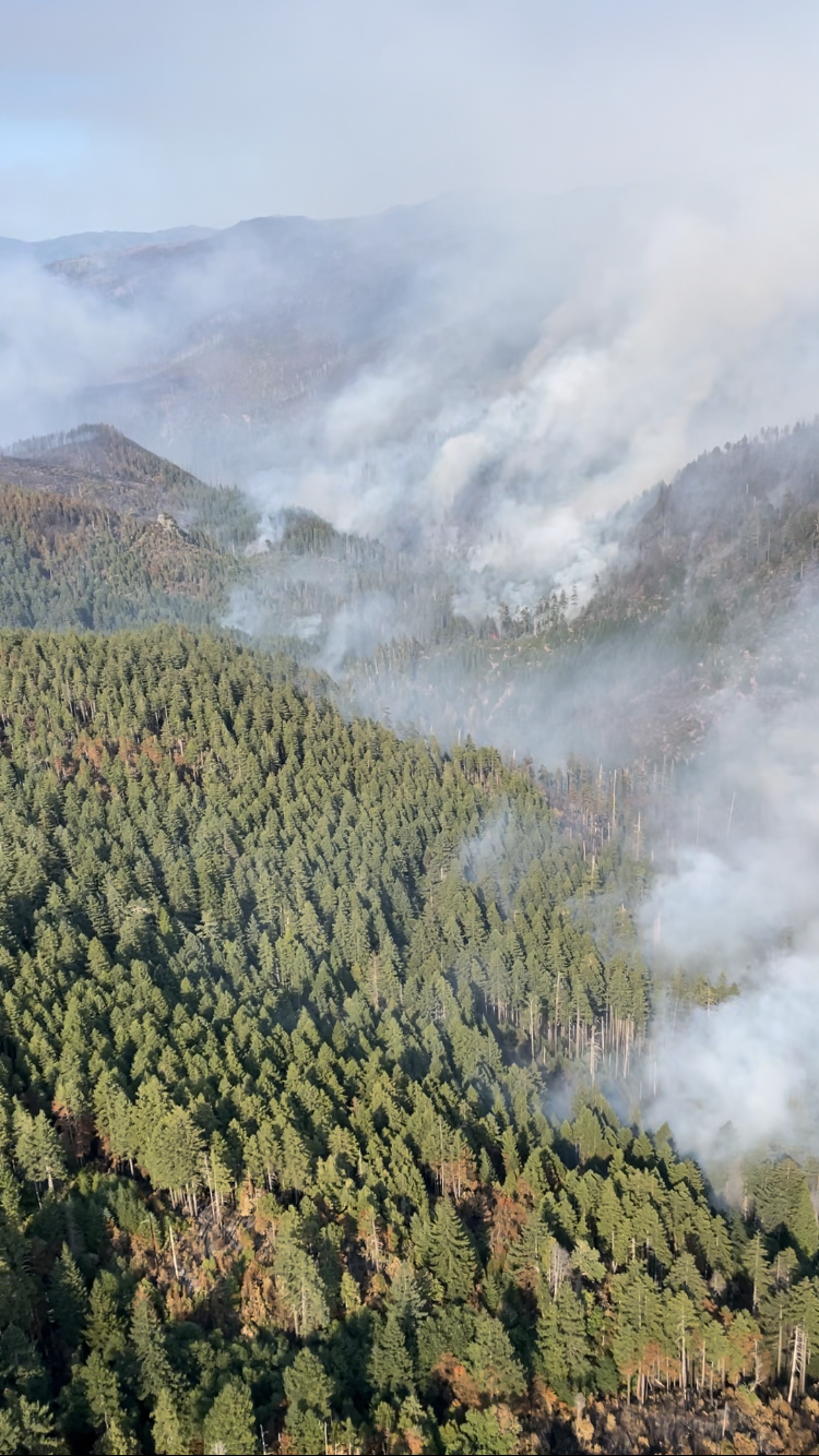
Thu, 08/03/2023 - 00:00
Overview of the interior of the fire area from the southwest. Photo taken on 8/2/2023 by James Osborne, Operations Section Chief
York Fire Evening Update for August 2 2023
Related Incident: 2023 - York Fire
Publication Type: News
Location: San Bernardino County, CA & Clark County, NV
Start Date: Friday July 28, 2023, at 12:09pm
Cause: Under Investigation
Size: 94,009 acres including 8,580 acres in Clark County, NV
Percent Contained: 34%
Vegetation: Timber (litter and Understory), and Brush
Number of Personnel Assigned: 423
As of 8/2/23, the York Fire is currently at 94,009 acres with 34% containment, 8,580 acres are in Clark County, NV.
Firefighters today, 8/2/23, continued to reinforce existing containment line while continuing to mop up. While the fire saw significant rainfall in the previous operational period today’s weather proved to bring higher temperatures. Firefighters will remain vigilant during the evening shift 8/2/23 looking for flareups along the fires edge. Firefighters continue to use minimal impact suppression tactics (MIST) using a light on the land approach while carefully protecting resources such as cultural histories, threatened wildlife, and rare plants.
The joint efforts to suppress the York Fire by bringing together resources from various agencies is a testament to the response during wildfire emergencies. The involvement of the National Park Service, Bureau of Land Management, United States Department of Agriculture Forest Service, California Department of Forestry and Fire Protection (CAL FIRE), San Bernardino County Fire Protection District, and Clark County Fire highlight the scale and severity of the fire and the need for extensive resources to tackle it effectively.
The staff of the York Fire are working closely with Clark County Communications to provide timely and accurate information to the public. If you have any questions regarding what is occurring specifically with the residential areas of Nipton and Searchlight, please reference Clark County Public Communications or their twitter at Clark County Nevada
WEATHER: The monsoonal influence is slowly leaving the area, we are anticipating warmer and dryer weather in the coming days.
EVACUATIONS: No current evacuations.
PARK & ROAD CLOSURES: Ivanpah Rd. between Morning Star Mine Rd and Cedar Canyon Rd., as well as all of Hart Mine Rd. are closed due to hazardous wildfire conditions and fire suppression operations. Please stay clear of the area. Mojave National Preserve is also under Extreme Fire Restrictions, please visit their website for more information on restrictions and closures: Alerts & Conditions - Mojave National Preserve (U.S. National Park Service) (nps.gov). Please visit Road Conditions - Mojave National Preserve (U.S. National Park Service) (nps.gov) to view a detailed map of current park closures.
Actualizacin del Incendio Lowline Mircoles 2 de Agosto 2023 900 pm
Related Incident: Lowline Fire
Publication Type: News
Equipo de Gestión de Incidentes del Complejo del área de las Montañas Rocosas 1
Dan Dallas, Comandante del Incidente
Teléfono de Información: 970-648-4470 (publico), 970-765-7123 (medios de comunicación)
Correo electrónico: 2023.lowline@firenet.gov
Horario: 8 a.m. – 8 p.m.
Nota Especial: Esta será la última actualización de la noche a menos que cambien las condiciones del incendio. Las actualizaciones diarias de las 9:00 a. m. por la mañana continuarán y se publicarán breves actualizaciones a lo largo del día en Facebook y InciWeb a medida que haya nueva información disponible.
Situación actual: Los bomberos se concentraron en patrullar las líneas de fuego, limpiar los puntos calientes y fortalecer las líneas de fuego en los bordes no contenidos. Como era de esperar, las carreteras mojadas y resbaladizas junto con el peligro de rayos impidieron el acceso a algunas áreas en el lado norte y no se produjeron operaciones de contrafuego. Las precipitaciones y las condiciones climáticas de los últimos días han ayudado significativamente a los bomberos al amortiguar el comportamiento del fuego, lo que permite acelerar la construcción de la línea de fuego. Cierta cantidad de línea de fuego está en su lugar alrededor de gran parte del perímetro, aunque todavía no todos los bordes están contenidos. Las líneas de fuego se crean eliminando las fuentes de combustible no quemadas, extinguiendo o reubicando las fuentes de calor y, literalmente, impidiendo el movimiento del fuego con líneas excavadas sobre la superficie y la capa orgánica del terreno, hasta llegar al suelo mineral., que generalmente se asemejan al ancho de un sendero. Los administradores de incendios no etiquetarán una parte de la línea de fuego como "contenida" hasta que estén seguros de que no hay calor en el perímetro y no hay posibilidad de crecimiento. La contención de hoy es 47% gracias al arduo trabajo de los bomberos y las condiciones climáticas favorables.
Esta noche, los camiones de bomberos patrullarán los bordes del incendio donde los caminos son seguros para viajar y evaluarán el comportamiento del fuego. Se espera una ola adicional de precipitaciones antes de la medianoche, lo que respaldará las acciones continuas de extinción de incendios mañana.
División A: El enfoque de hoy estuvo en el lado norte, donde los bomberos continuaron avanzando para asegurar la línea de fuego a lo largo de Middle Creek. En el extremo este, donde la contención es mayor, se estaban llevando a cabo actividades de patrullaje y limpieza.
División Z: las líneas de fuego existentes fueron patrulladas, fortalecidas y limpiadas. Los bomberos fueron ayudados por datos de un vuelo infrarrojo anoche que detectó varias fuentes de calor cerca de la línea. Estas fuentes estaban quemando agujeros de tocones y se extinguieron rápidamente. Los bomberos no pudieron realizar operaciones de quema en el larguero de madera, pero completarán esta acción una vez que las condiciones lo permitan.
División Y: Los bomberos continuaron patrullando, limpiando y fortaleciendo las líneas de fuego en preparación para posibles operaciones de contrafuego más adelante en la semana. En la parte superior de la cresta, la vegetación es predominantemente álamo temblón, que no ha sufrido incendios hasta la fecha.
División X: Según lo planeado, hoy no se realizaron acciones en esta división debido a su ubicación cerca del área silvestre West Elk y prioridades más altas en otras divisiones. Los incendios en áreas remotas a menudo representan peligros adicionales para los bomberos debido al acceso limitado y el terreno en esta región es empinado y accidentado. Las actividades de supresión en esta área sopesarán el riesgo para los bomberos mientras aprovechan las características naturales y el clima.
División W: Los bomberos ampliaron la construcción principal de la línea de fuego desde la ruptura de la División A a lo largo de Middle Creek hasta la intersección con el sendero Lowline. También fortalecieron la línea de fuego de contingencia después de Price Creek. Tanto la línea de fuego principal como la de contingencia se originan en la ruptura de la división, aunque se conectan al sendero Lowline en dos ubicaciones diferentes aproximadamente a 1 milla de distancia formando una forma triangular. Si las condiciones futuras de incendio requieren una operación de contrafuego, los bomberos quemarán el área triangular entre las dos líneas de fuego. Los administradores de incendios identificaron la ubicación para la colocación de la línea de fuego entre el sendero Lowline al oeste del descanso de la División X y la construcción comenzó con trabajo adicional planificado para mañana.
Protección de la estructura: A lo largo de este incendio forestal, el enfoque ha sido doble: contener el fuego y proteger la infraestructura y la propiedad privada a lo largo de los bordes este, sur y norte, al mismo tiempo que se brinda protección a los bomberos y al público. La protección de la estructura en forma de evaluaciones, instalación de rociadores y otras medidas proporciona una línea de defensa adicional.
Condiciones Climáticas y de Combustible:
A partir de mañana, el cielo estará mayormente soleado, aunque se mantendrá alguna probabilidad de lluvias y tormentas eléctricas, 35%. No se espera lluvia mojada y se espera que la humedad sea un 10% más baja que hoy en el rango bajo del 30%. Las temperaturas y el viento serán similares a los de hoy, a mediados de los 70 a unas 10-15 mph con ráfagas de hasta 25 mph, respectivamente. Con estas condiciones, el comportamiento del fuego aumentará con más humo, humo más oscuro y posiblemente una columna de humo visible, especialmente en las horas de la tarde, cuando el sol calienta más intensamente los combustibles.
Evacuaciones, Cierres, y Restricciones de Incendios:
Se han realizado evacuaciones obligatorias en los drenajes de Squirrel Creek y Mill Creek. Para obtener información específica sobre evacuación, consulte Manejo de emergencias del condado de Gunnison en www.gunnisoncounty.org. Puede registrarse para recibir alertas de emergencia en sus teléfonos u otros dispositivos en: https://bit.ly/3QhZVZg.
Se ha implementado cierre de áreas, caminos y senderos en tierras del Sistema Forestal Nacional cerca del incendio. Para obtener detalles, consulte este enlace: https://www.fs.usda.gov/Internet/FSE_DOCUMENTS/fseprd1126172.pdf. BLM ha implementado un cierre temporal en la vecindad del incendio. Para obtener más información, consulte este enlace: www.blm.gov/programs/public-safety-and-fire/fire-and-aviation/regional-information/colorado/southwest-district. Las carreteras del condado en la vecindad del incendio están bloqueadas. En interés de la seguridad pública, los bomberos piden a los visitantes que estén atentos al tráfico de incendios y que eviten el área.
Actualmente no hay restricciones de incendios en el condado de Gunnison. Si se implementan restricciones, se publicarán en este sitio: https://westslopefireinfo.com/gunnison-county/.
Los incendios forestales son una zona de exclusión aérea para aeronaves no autorizadas, incluidos los drones. Si tu vuelas, nosotros no podemos. Para obtener más información, visite http://knowbeforeyoufly.org.
Estadísticas del Incendio Lowline:
Tamaño: 1771 acres
Contenido: 47%
Personal: 394
Locación: 14 mi. NNW de Gunnison, CO
Reportado: 8:00 am 26 de Julio, 2023
Causa: Relámpago
Para más Información:
Línea Telefónica: 970-648-4470 (publicó), 970-765-7123 (media)
Correo electrónico: 2023.lowline@firenet.go
InciWeb: https://inciweb.wildfire.gov/incident-information/cogmf-lowline-fire
Facebook: www.facebook.com/GMUGFireInfo
Lowline Fire Update Wednesday August 2 2023 900 pm
Related Incident: Lowline Fire
Publication Type: News
Rocky Mountain Complex Incident Management Team 1
Dan Dallas, Incident Commander
Information Phone: 970-648-4470 (public), 970-765-7123 (media)
Email: 2023.lowline@firenet.gov
Information Staffing Hours: 8 a.m. to 8 p.m.
Current Situation: Firefighters focused on patrolling firelines, mopping up hot-spots, and strengthening firelines on the uncontained edges. As expected, wet, slick roads coupled with lightning hazard prevented access to some areas on the north side and no burnout operations occurred. Precipitation and weather conditions over the last several days, have significantly aided firefighters by dampening fire behavior allowing for accelerated fireline construction. Some amount of fireline is in place around much of the perimeter even though not all edges are contained yet. Firelines are made by removing unburned fuel sources, extinguishing or relocating heat sources, and preventing the fire’s movement with lines dug down to bare soil, typically resembling the width of trail. Fire managers will not label a portion of fireline “contained” until they are confident there is no heat on the perimeter and no chance for growth. Today’s containment is now 47% thanks to the very hard work of firefighters and favorable weather conditions.
Tonight, fire engines will patrol fire edges where roads are safe for travel and assess fire behavior. An additional wave of precipitation is expected before midnight, which will support continued fire suppression actions tomorrow.
Division A: Today’s focus was on the northern side where firefighters continued progress to secure the fireline along Middle Creek. On the eastern edge, where containment is greatest, patrol and mop-up activities were ongoing.
Division Z: Existing firelines were patrolled, strengthened, and mopped-up. Firefighters were aided by data from an infrared flight last night which detected several heat sources near the line. These sources were burning stump holes and were quickly extinguished. Firefighters were unable to conduct burning operations in the timber stringer but will complete this action when conditions allow.
Division Y: Firefighters continued to patrol, mop up, and strengthen firelines in preparation for possible burnout operations later in the week. On top of the ridge, vegetation is predominately aspen, which has not sustained fire to date.
Division X: As planned, no actions occurred in this division today due to its location near the West Elk Wilderness and higher priorities in other Divisions. Fires in remote areas often pose additional hazards to firefighters due to limited access and steep, rugged terrain. Suppression activities in this area will weigh risk to firefighters while using natural features and weather to an advantage.
Division W: Firefighters expanded the primary fireline construction from the Division A break along Middle Creek to the intersection with the Lowline Trail. They also strengthened the contingency fireline following Price Creek. Both the primary and contingency firelines originate at the division break although connect to the Lowline Trail at two different locations approximately 1 mile apart forming a triangular shape. Should future fire conditions require a burnout operation, firefighters will burn the triangular area between the two firelines. Fire managers identified the location for fireline placement between the Lowline Trail west to the Division X break and construction began with additional work planned for tomorrow.
Structure Protection: Throughout this wildfire, focus has been two-fold: containing the fire and protecting infrastructure and private property along the eastern, southern, and northern edges while providing for firefighter and public safety. Structure protection in the form of assessments, sprinkler installation, and other measures provides an additional line of defense.
Weather & Fuel Conditions:
Starting tomorrow, skies will be mostly sunny although some chance of showers and thunderstorms, 35%, will remain. No wetting rain is expected and humidity is expected to be 10% lower than today in the low 30% range. Temperatures and wind will be similar to today, in the mid-70s at about 10-15 mph with gusts up to 25 mph, respectively. With these conditions, fire behavior will pick up with more smoke, darker smoke, and possibly a smoke column visible especially in the afternoon hours when the sun is most intensely warming fuels.
Evacuations, Closures, and Fire Restrictions:
Mandatory evacuations are in place in the Squirrel Creek and Mill Creek drainages. For specific evacuation information, see Gunnison County Emergency Management at www.gunnisoncounty.org. You may sign up to receive emergency alerts on your phones or other devices at: https://bit.ly/3QhZVZg .
An area, road, and trail closure has been implemented on National Forest System lands near the fire area. For specifics see this link: https://www.fs.usda.gov/Internet/FSE_DOCUMENTS/fseprd1126172.pdf . BLM has implemented a temporary closure in the fire vicinity. For details see this link: www.blm.gov/programs/public-safety-and-fire/fire-and-aviation/regional-information/colorado/southwest-district . County Roads in the fire vicinity are barricaded. In the interest of public safety, fire officials ask visitors to be aware of fire traffic and avoid the area.
There are currently no fire restrictions in Gunnison County. Should restrictions be implemented, they will be posted at this site: https://westslopefireinfo.com/gunnison-county/ .
Wildfires are a no-fly zone for unauthorized aircraft, including drones. If you fly, we can’t. For more information, visit http://knowbeforeyoufly.org.
Lowline Fire Statistics:
Size: 1771 acres
Containment: 47%
Total Personnel: 394
Location: 14 mi. NNW of Gunnison, CO
Reported: 8:00 am July 26, 2023
Cause: lightning
For More Information:
Information Phone: 970-648-4470 (public), 970-765-7123 (media)
Email: 2023.lowline@firenet.gov
InciWeb: https://inciweb.wildfire.gov/incident-information/cogmf-lowline-fire
Facebook: www.facebook.com/GMUGFireInfo
Structures Lost at Allison Ranch and Yellow Pine Ranch during a Firestorm
Related Incident: Elkhorn Fire
Publication Type: Announcement
Structures Lost at Allison Ranch and Yellow Pine Ranch during a Firestorm
Elkhorn Fire Information - InciWeb the Incident Information System (nwcg.gov)
McCall, Idaho – August 2, 2023: In the early afternoon of July 30, 2023, the Elkhorn Fire began taking what would be by the end of the day, a 20,000-acre run of extreme fire behavior up the Salmon River. In the path of the fire were Allison Ranch and Yellow Pine Ranch. Unfortunately, seven structures at Allison Ranch and one at Yellow Pine Ranch were a complete loss, and another partially damaged at Yellow Pine Ranch.
Shortly after the morning inversion cleared, a notable increase in fire behavior took place on the south side of the river, and a substantial smoke column developed. Within minutes, the fire had crossed the river in the area of Allison Ranch where firefighters acted by using the sprinklers, pumps, and hose lays already in place at the ranch in an effort to protect the structures. Soon, another report of the fire having crossed the river at Yellowpine Ranch came in. Within the next hour, the smoke column collapsed. Firefighters who were at Allison Ranch estimated 50, then 60 and even as high as 90 miles per hour wind blowing from all directions with large burning pieces of debris flying through the air. Firefighters remained on site to provided structure protection as long as they could but had to evacuate the area due in extreme fire behavior and burn intensity. Structure protection took place at Yellow Pine Ranch as well that helped minimize the damage.
What was different this time? Fire and structure protection has taken place at ranches along the river many times in previous years. This time was the perfectly wrong alignment of fuels, terrain and weather that equated to the significant fire behavior that took place. While the loss of the structures is unfortunate, we are thankful that all firefighters and members of the public that were with them were quickly accounted for.
The Payette National Forest has a public wildfire information hotline for fire information – 208-634-0820. Visit Inciweb for information on large wildfires at https://inciweb.nwcg.gov , and follow the Payette National Forest on Twitter at @PayetteForest, and on Facebook at U.S. Forest Service – Payette National Forest.
###
Flat Fire Community Meeting in Agness August 4 2023
Related Incident: Flat Fire
Publication Type: Announcement
The Flat Fire is hosting an in-person Community Meeting in Agness on Friday, August 4 at the Agness Community Library Day Park.