
Spoon Fire Daily Update August 3 2023
Related Incident: Spoon Fire
Publication Type: News
Natural Barriers Allow Crews to Make Progress on Fires
Cottonwood Ridge, Snake Ridge, Spoon and New Fire Starts – August 3, 2023, Daily Update
Spoon Fire Quick Facts
Acres: 4,560 acres
Cause: Lightning
Containment: 35%
Start Date: July 24, 2023
Location: 2.5 miles east of Highway 60 between Globe and Show Low, AZ. 11 miles southwest of Cedar Creek
Fuels: Piñyon- Juniper, Manzanita, Grass, Cedar
Total personnel for all incidents: 428
Despite the hot, dry, and breezy weather Wednesday, crews made steady progress on all fires. Many heat sources within the fire perimeters are slowly burning out, allowing firefighters to mop up and make good progress on containment efforts.
New fires identified yesterday were caught quickly due to rapid initial attack response from firefighters. Two of the new starts were stopped at one acre. Crews were able to confirm that another new start has no remaining heat sources. One fire had firefighters rappel out of a helicopter to contain the fire and ensure no heat sources remained near containment lines. Two additional fires have two crews and engines providing fire response efforts.
Crews will begin repairing damage caused by building containment lines, including water barring areas where the fire is cold to the touch. They will also continue to construct handlines and dozer lines along the fire’s edge.
Spoon Fire Update: Fire crews dispersed and detected minimum heat sources along containment lines resulting in the ability to increase the fire’s containment by 10%, amounting to a total of 35% containment. Crews will begin scouting the fire area to identify suppression and repair needs.
Weather: Warm weather in the 90s along with dry and breezy conditions are expected in the coming days. The weather continues to provide potential for news fire starts, but firefighters remain ready to respond to any news fires.
Evacuations: None. For awareness regarding evacuations, familiarization with the Ready, Set, Go evacuation model is encouraged. Community members may also sign up for the Navajo County Alert System at https://tinyurl.com/y4vwrasw.
Smoke: Smoke may still be visible as pockets of heat continue to smolder. For information on smoke and air quality, visit https://www.airnow.gov.
Closures: Highway 60 remains open. The southwest portion of Fort Apache is closed, including all Salt River sites within the closure area.
Fire Restrictions: There are several fire restrictions in place depending on location.
- Fort Apache Agency: Stage 2 Fire Restrictions
No campfire, fireworks, outdoor smoking, debris burning or discharging of firearms. Power saws cannot be used between 10 am and 8 pm. All motorized travel is restricted to developed roads. - Show Low, Navajo County and Apache Sitgreaves National Forests: Stage 1 Fire Restrictions
No campfires (except in developed recreation sites), no smoking outdoors, no welding, no fireworks.
More Information:
Inciweb:
- Cottonwood Ridge: https://inciweb.nwcg.gov/incident-information/azfta-cottonwood-ridge-fire
- Spoon: https://inciweb.nwcg.gov/incident-information/azfta-spoon-fire
Facebook: https://www.facebook.com/BIAFAAFireMgt/
Smoke Outlook for August 3 4 2023
Related Incident: Bedrock Fire
Publication Type: News
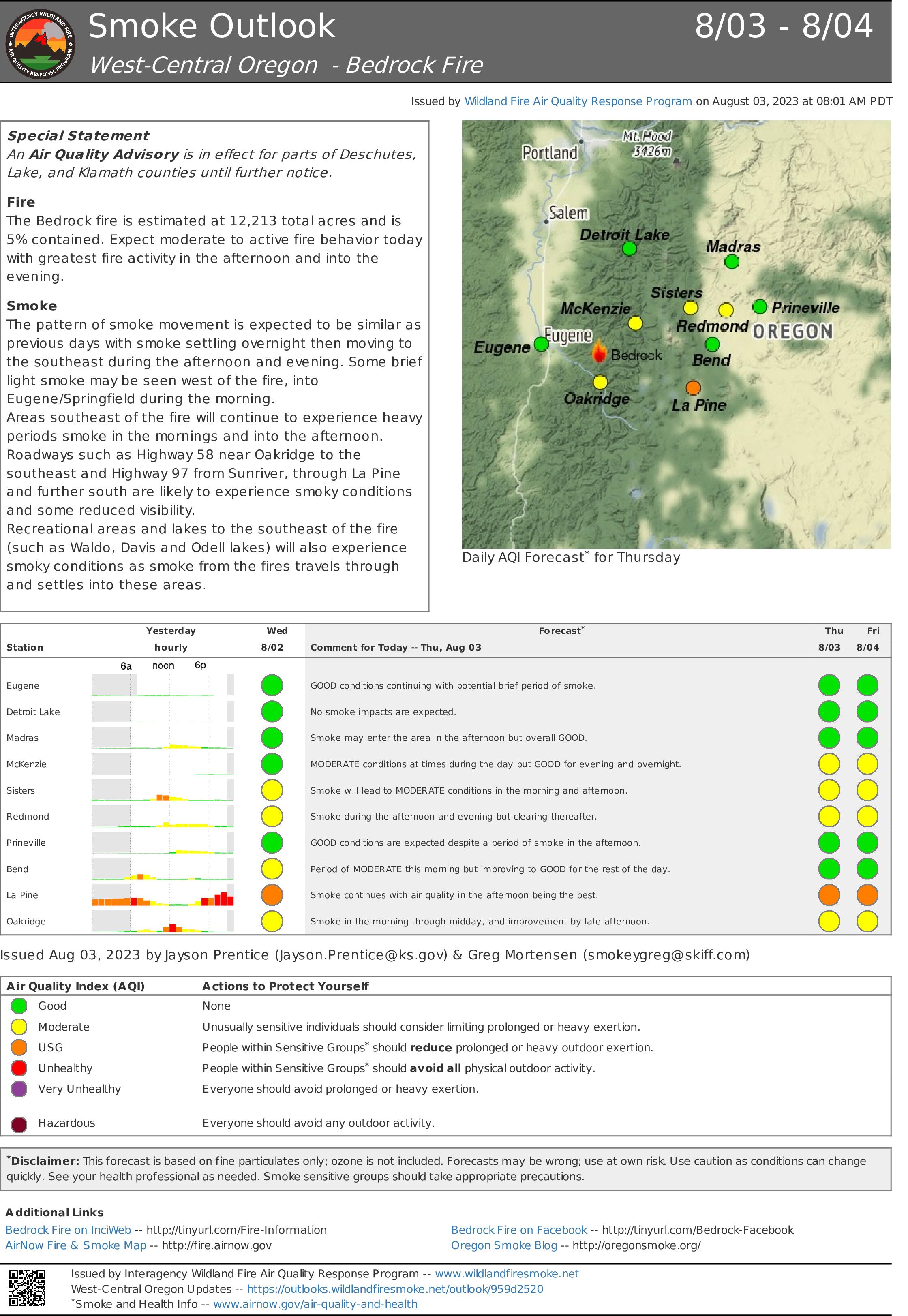
The Bedrock fire is estimated at 12,213 total acres and is 5% contained. Expect moderate to active fire behavior today with greatest fire activity in the afternoon and into the evening.
The pattern of smoke movement is expected to be similar as previous days with smoke settling overnight then moving to the southeast during the afternoon and evening. Some brief light smoke may be seen west of the fire, into Eugene/Springfield during the morning.
Areas southeast of the fire will continue to experience heavy periods smoke in the mornings and into the afternoon. Roadways such as Highway 58 near Oakridge to the southeast and Highway 97 from Sunriver, through La Pine and further south are likely to experience smoky conditions and some reduced visibility.
Recreational areas and lakes to the southeast of the fire (such as Waldo, Davis and Odell lakes) will also experience smoky conditions as smoke from the fires travels through and settles into these areas.
Flat Fire Morning Update 8032023
Related Incident: Flat Fire
Publication Type: News
August 3, 2023
Flat Fire Morning Update
Start Date: July 15, 2023
Size: 31,472 acres
Point of origin: 2 miles southeast of Agness, OR
Containment: 28%
Cause: Human caused
Total personnel: 1,104
Resources: 39 engines l 16 crews l 1 bulldozer l 24 water tenders l 4 masticators l
9 helicopters
Current Situation:
Helicopters continued with aerial ignition to achieve additional depth from the containment line further into the unburned interior in the southwest corner of the fire in the Lawson Creek drainage. With fuels drying out, where fire has been backing down slopes in the recent days and natural fuels lower on the slope align, some uphill runs are now occurring. This results in better overall unburned vegetation consumption, so fuels are less likely to re-burn.
Firefighters also used aerial ignition in the Game Lake area to improve the depth of burned fuels from containment lines. A helitack crew (a firefighting crew flown in by helicopter) was inserted into the Fantz Ranch area along the eastern edge of the fire to cool areas of heat identified through infra-red photography/imaging. This will help to check fire movement further east. Firefighters are monitoring an area of increased interior heat identified through infrared detection in the north fork of Indigo Creek and using helicopter bucket drops as needed to secure the existing containment line. Night-shift resources held and patrolled fireline.
Structure protection resources are using vehicles and aircraft to locate and identify additional homes and buildings, and are collecting data to aid firefighters in protecting structures if there is a future need. The alternate control line on Forest System Roads (FSR) 3313, 1503, and 3680 continues to be improved.
Today’s activities: The aerial ignition efforts over the past several days to gain additional fireline depth between the western and eastern portions of FSR 3680 in the Lawson Creek drainage (southwestern corner of the fire) is planned for completion today. Aerial interior burning will also continue in the Game Lake area as time and conditions allow. A heli-torch will be available to use in areas of more sparse vegetation to increase fuels consumption and overall burn effectiveness. The helitack crew will take additional checking actions in the Fantz Ranch area. The western and northern containment lines, from the junction of FSR 3680 and 3318 to Wildhorse Lookout east to FSR 3577, is being actively mopped up and patrolled. The northeast corner of the fire, using FSR 2308 and 150, has been fully prepared for firing operations if the need arises due to changes in weather conditions and/or fire activity.
With fire traffic on Bear Camp Road, all motorists on Bear Camp Road are asked to slow down, use headlights and proceed with caution.
There is no longer an evening fire update but current information will continue to be posted on Inciweb, Facebook and Twitter.
Evacuations: All remaining evacuation levels are now at Level 1 “Get Ready” evacuation status for all areas in the vicinity of the Flat Fire.
The Curry County Sheriff’s Office will continue to coordinate with the Fire Incident Management Team and will notify all residents affected by the fire of any reasons to change evacuation levels.
Curry County is using Everbridge to send evacuation notices. You can sign up for notifications here: https://www.co.curry.or.us/departments/emergency_management/index.php.
Weather: Today’s forecast calls for slightly cooler temperatures (down 1-3 degrees) and higher relative humidity (up 1-3%). The up and down weather cycle we have been experiencing has moderated fire behavior but overall fuels are continuing to dry. A warmer and drier air mass is predicted to return by the weekend.
Smoke: The Smoke Outlook is available at: https://outlooks.airfire.org/outlook/en/b74901f7
Closures: The Rogue River-Siskiyou National Forest (RRSNF) has issued a closure order for the fire area including trails, roads and a portion of the Illinois River. Oak Flat Campground, Game Lake and Wild Horse Campgrounds and Snow Camp Lookout Recreation Rentals are all closed as part of the area closure. The Chetco River Road (FSR 1376) and Chetco/Pistol River Road (FSR 1407) are now closed. The updated closure allows for public access to the Big Rock swimming hole on the Illinois River.
Restrictions: Fire danger is currently extreme; the RRSNF is implementing Level 2 Public Use Restrictions beginning on August 4. More information can be found here:https://tinyurl.com/bdzbae69.
Please follow all fire restrictions to prevent wildfires. When restricted, smoking is only allowed in vehicles on improved roadways.
West Hallett and West Anderson Fire Update 832023
Related Incident: West HallettWest Anderson
Publication Type: News
Cheney, WA, - The West Hallett Fire was reported at 1337 on Monday July 31st. It is located approximately 2 miles West of Highway 195 North of the Cheney Spokane Road.
Cheney, WA, - The West Anderson Fire was reported at 1708 on Wednesday August 2nd. It is located approximately ½ mile east of the city of Cheney North of Anderson Road.
Currently there are approximately 200 line and support personnel assigned to the fires.
The West Hallett fire is 60% contained and is sized at approximately 155 acres. Evacuation levels have been changed to level 1 (be Ready to go) for the fire. See attached map for clarification.
The West Anderson Fire is 0% contained and is sized at approximately 35 acres. Evacuation levels are at level 2 (Be set to go) for areas along Anderson road south of Cheney Spokane Road. See attached map for clarification.
Washington Department of Natural Resources and Spokane County Fire District 3 have assigned management of both fires to a Northeast Washington Interagency Type 3 Incident Management Team.
On West Hallett, firefighters will continue to build on the successes of the last few days and to make progress toward the fire being 100% mopped up.
On West Anderson, firefighters will continue to gain better access as vehicle access is limited. They will work to finalize and enhance control lines around the fire while starting to mop up the perimeter.
Initial mop up is for 300 feet around all structures and 100 foot perimeter around the entire fire working towards 100% extinguishment.
The incident command post is located at the Cheney middle School in Cheney WA. Fire information contact is Eric Keller at 509-481-7064.
Road Closures in Effect for the East Side and West Side South Fork Roads
Related Incident:
Publication Type: Announcement
ATTENTION!
To provide for public and firefighter safety, the East Side South Fork Road #38 is closed to public travel and the West Side South Fork Road #895 is closed to public travel near the 15 mile just past the Lid Creek Campground. Starting tomorrow, August 8th, West Side South Fork Road #895 will be closed starting at the dam extending to the existing closure at mile 15, near Lid Creek Campground. West Side South Fork Road #895 remains closed beyond Lid Creek Campground.
Cottonwood Ridge Update August 3 2023
Related Incident: Cottonwood Ridge Fire
Publication Type: News
Natural Barriers Allow Crews to Make Progress on Fires
Cottonwood Ridge, Snake Ridge, Spoon and New Fire Starts – August 3, 2023, Daily Update
Cottonwood Ridge Fire Quick Facts
Acres: 345
Cause: Lightning
Containment: 65%
Start Date: July 23, 2023
Location: 4 miles south of Show Low, AZ
Fuels: Timber, grass, brush
Snake Ridge Fire Quick Facts
Acres: 42 acres
Cause: Lightning
Containment: 79%
Start Date: July 28, 2023
Location: 11 miles southwest of Show Low, AZ.
Fuels: Grass, Brush
Total personnel for all incidents: 428 (Cottonwood Ridge, Snake Ridge, Spoon, and new start fires)
Despite the hot, dry, and breezy weather Wednesday, crews made steady progress on all fires. Many heat sources within the fire perimeters are slowly burning out, allowing firefighters to mop up and make good progress on containment efforts.
New fires identified yesterday were caught quickly due to rapid initial attack response from firefighters. Two of the new starts were stopped at one acre. Crews were able to confirm that another new start has no remaining heat sources. One fire had firefighters rappel out of a helicopter to contain the fire and ensure no heat sources remained near containment lines. Two additional fires have two crews and engines providing fire response efforts.
Crews will begin repairing damage caused by building containment lines, including water barring areas where the fire is cold to the touch. They will also continue to construct handlines and dozer lines along the fire’s edge.
Cottonwood Ridge Fire Update: Crews are patrolling the fire perimeter for hotspots, finding few heat sources along established containment lines. Their diligent efforts provided a 15% increase to the fire’s containment, amounting to a total of 65% containment.
Snake Ridge Fire Update: Crews spread out to patrol the fire for hotspots, like the Cottonwood Ridge and Spoon fires, they found little need for mop up and their efforts provided a substantial 29% increase to the fire’s containment, amounting to a total of 79% containment.
Weather: Warm weather in the 90s along with dry and breezy conditions are expected in the coming days. The weather continues to provide potential for news fire starts, but firefighters remain ready to respond to any news fires.
Evacuations: None. For awareness regarding evacuations, familiarization with the Ready, Set, Go evacuation model is encouraged. Community members may also sign up for the Navajo County Alert System at https://tinyurl.com/y4vwrasw.
Smoke: Smoke may still be visible as pockets of heat continue to smolder. For information on smoke and air quality, visit https://www.airnow.gov.
Closures: Highway 60 remains open. The southwest portion of Fort Apache is closed, including all Salt River sites within the closure area.
Fire Restrictions: There are several fire restrictions in place depending on location.
- Fort Apache Agency: Stage 2 Fire Restrictions
No campfire, fireworks, outdoor smoking, debris burning or discharging of firearms. Power saws cannot be used between 10 am and 8 pm. All motorized travel is restricted to developed roads. - Show Low, Navajo County and Apache Sitgreaves National Forests: Stage 1 Fire Restrictions
No campfires (except in developed recreation sites), no smoking outdoors, no welding, no fireworks.
More Information:
Inciweb:
- Cottonwood Ridge: https://inciweb.nwcg.gov/incident-information/azfta-cottonwood-ridge-fire
- Spoon: https://inciweb.nwcg.gov/incident-information/azfta-spoon-fire
Facebook: https://www.facebook.com/BIAFAAFireMgt/
Actualizacin del Incendio Lowline Jueves 3 de Agosto 2023 900 am
Related Incident: Lowline Fire
Publication Type: News
Equipo de Gestión de Incidentes del Complejo del área de las Montañas Rocosas 1
Dan Dallas, Comandante del Incidente
Teléfono de Información: 970-648-4470 (publico), 970-765-7123 (medios de comunicación)
Correo electrónico: 2023.lowline@firenet.gov
Horario: 8 a.m. – 8 p.m.
Situación Actual: Durante la noche, el comportamiento del fuego volvió a disminuir debido a una ola de humedad que atravesó el área del incendio. La humedad de esta mañana, midiendo cerca de 100 %, mantendrá la actividad del fuego desanimada por un tiempo, pero disminuirá a lo largo del día y el comportamiento del fuego se recuperará más tarde. Los bomberos continuarán con las tácticas del día anterior de mejorar las líneas de fuego, patrullar las líneas de fuego existentes y proteger cualquier calor que se encuentre cerca de la línea. Si las condiciones son lo suficientemente secas para que el fuego se encienda y avance, también se pueden realizar operaciones quema de ensanche para aumentar la profundidad del cortafuegos y reducir las cargas de combustible en el interior.
División A: Los administradores de incendios pueden usar un helicóptero o un sistema de aeronave no tripulada (UAS) para encender bolsas de combustible en el interior. Esta acción depende de las condiciones climáticas y consiste en que los administradores de incendios dejen caer pelotas del tamaño de una mesa de ping pong que contienen sustancias químicas que encienden el fuego en los lugares deseados. Este fuego encendido intencionalmente y con precisión tiene menos intensidad y alturas de llama más bajas que sirven para eliminar los combustibles del fuego principal. Las cuadrillas continuarán limpiando y patrullando la línea de fuego contenida además de fortalecer las acciones en la línea de fuego no contenida.
División Z: Los bomberos continuarán trabajando en el último segmento de la línea de fuego no contenido en el lado oeste con una contención total probable en esta división. La seguridad de las secciones contenidas también se mantendrá mediante el patrullaje y la limpieza.
División Y: No se planean operaciones de quema de ensanche para hoy, aunque los bomberos siguen preparados para quemar a lo largo de la cresta si fuera necesario. Las cuadrillas patrullarán, limpiarán y asegurarán las líneas de fuego contenidas. Se anticipa que la construcción de la línea llegará hoy al límite del área silvestre en el receso de la División X.
División X: Los administradores de incendios están evaluando opciones para esta área. El trabajo en el suelo no ocurrirá hoy ya que los recursos están completando el trabajo de mayor prioridad en otras divisiones. Los futuros esfuerzos de supresión dentro de la División aprovecharán las características naturales y el clima mientras pulsan el riesgo para los bomberos.
División W: Las cuadrillas sostendrán progreso a lo largo de esta división y continuar con la construcción de la línea de fuego mientras se fortalecen las líneas a través del patrullaje, la limpieza y liando con los puntos críticos según sea necesario.
Protección de Estructuras: Los Bomberos continuarán con los trabajos de protección de estructuras de días anteriores; evaluaciones, instalaciones de rociadores y otras medidas según sea necesario.
Condiciones Climáticas y de Combustible:
Hoy se pronostican cielos soleados con temperaturas a mediados de los 70, vientos que oscilan entre 10 y 15 mph con ráfagas de hasta 25 mph y humedad en el rango bajo del 30%. Hoy es la última oportunidad de actividad de tormenta eléctrica en 35%. Estas condiciones de secado permitirán un comportamiento más activo del fuego. Las áreas con vegetación mixta de coníferas y árboles pesados muertos y caídos experimentarán la mayor actividad de incendios.
Evacuaciones, Cierres, y Restricciones de Incendios:
Se han realizado evacuaciones obligatorias en los drenajes de Squirrel Creek y Mill Creek. Para obtener información específica sobre evacuación, consulte Manejo de emergencias del condado de Gunnison en www.gunnisoncounty.org. Puede registrarse para recibir alertas de emergencia en sus teléfonos u otros dispositivos en: https://bit.ly/3QhZVZg.
Se ha implementado cierre de áreas, caminos y senderos en tierras del Sistema Forestal Nacional cerca del incendio. Para obtener detalles, consulte este enlace: https://www.fs.usda.gov/Internet/FSE_DOCUMENTS/fseprd1126172.pdf. BLM ha implementado un cierre temporal en la vecindad del incendio. Para obtener más información, consulte este enlace: www.blm.gov/programs/public-safety-and-fire/fire-and-aviation/regional-information/colorado/southwest-district. Las carreteras del condado en la vecindad del incendio están bloqueadas. En interés de la seguridad pública, los bomberos piden a los visitantes que estén atentos al tráfico de incendios y que eviten el área.
Actualmente no hay restricciones de incendios en el condado de Gunnison. Si se implementan restricciones, se publicarán en este sitio: https://westslopefireinfo.com/gunnison-county/.
Los incendios forestales son una zona de exclusión aérea para aeronaves no autorizadas, incluidos los drones. Si tu vuelas, nosotros no podemos. Para obtener más información, visite http://knowbeforeyoufly.org.
Estadísticas del Incendio Lowline:
Tamaño: 1770 acres
Contenido: 47%
Personal: 394
Locación: 14 mi. NNW de Gunnison, CO
Reportado: 8:00 am 26 de Julio, 2023
Causa: Relámpago
Para más Información:
Línea Telefónica: 970-648-4470 (publico), 970-765-7123 (media)
Correo electrónico: 2023.lowline@firenet.gov
InciWeb: https://inciweb.wildfire.gov/incident-information/cogmf-lowline-fire
Facebook: www.facebook.com/GMUGFireInfo
Niarada Fire Update August 3 2023
Related Incident: Niarada
Publication Type: News
Big Knife, Niarada, & Mill Pocket Fires
Confederated Salish and Kootenai Tribes
Fire Information: 406-426-9595 | 2023.BigKnife@firenet.gov
https://tinyurl.com/BigKnifeFire https://tinyurl.com/NiaradaMillPocketFires
August 3, 2023
Location: Big Knife - 5 miles east of Arlee, MT | Niarada - 12 miles west of Elmo, MT | Mill Pocket: 3 miles West of Hwy. 28
Start Date: Big Knife - 7/24/2023 | Niarada - 7/30/2023 | Mill Pocket – 7/30/2023 Cause: Lightning
Big Knife - 2,710 acres, 0% contained | Niarada - 13,686 acres, 0% contained | Mill Pocket – 1,929 acres, 0% contained
Total Personnel: 211 total Engines: 24 Aircraft: 1 + others available as needed Hand Crews: 5
Community meeting TONIGHT!
Join us for a community meeting regarding the Big Knife, Niarada, and Mill Pocket fires tonight, Thursday, August 3, 2023, 6:00 PM, at the Arlee Community Center, 34086 Pow Wow Road in Arlee. We will broadcast the meeting live on the CSKT Division of Fire Facebook page (www.facebook.com/CSKT.Division.of.Fire). We will host a second community meeting Friday, August 4, 2023, 6:00 PM, at the Elmo Community Center, 47088 Cemetery Road in Elmo. We will either broadcast that meeting live on Facebook or record and post to Facebook afterwards, depending upon internet connectivity.
Big Knife Fire
The Big Knife Fire burned actively Wednesday, with a spot fire south of Big Knife Creek burning eastward into the South Fork Jocko Tribal Primitive Areas and a portion of the fire also well-established on the north side of the Big Knife drainage. The fire is burning in extremely steep terrain, so crews continue to try to flank the fire and monitor the southwest edge. Strategic firing operations may be necesssary to prevent spread to the west toward the valley. Aircraft are aiding crews as conditions allow, although limited visibility has hindered some air operations. Big Knife Fire remains visible from Missoula and throughout the Jocko Valley.
Niarada Fire & Mill Pocket Fire
The Niarada Fire remained active Wednesday, spreading both to the northeast and southeast. Crews, heavy equipment, engines, helicopters, and fixed-wing aircraft continue to work the fire, building firelines from safe anchor points and protecting structures in the area. Late Tuesday and Wednesday, the Flathead Interagency Hotshot Crew successfully implemented strategic firing operations on the north perimeter along Cromwell Creek Road, helping secure the fire perimeter nearest Lake Mary Ronan. So far, crews are successfully holding that line. Crews are also scouting for opportunities to stop the fire’s southeasterly progression, where erratic winds and heavy fuels are hampering containment. Firefighters made great headway on the Mill Pocket Fire Wednesday, completing initial fireline around the entire perimeter. However, crews need to improve and hold that line before containment is achieved.
WEATHER AND FIRE BEHAVIOR
Hot, dry weather is forecast through Friday, with the potential for thunderstorms and light precipitation by late weekend. Based upon weather conditions and trends, there is continued potential for active fire behavior and large fire growth.
CLOSURES AND SPECIAL MESSAGES
The Lake County Sheriff has several areas near the base of the mountains west of the Big Knife Fire in PRE-EVACUATION status. See the map for those locations in yellow (Jocko, Canal, Francis). In the Tribal Primitive Area, Belmore Slough and Burnt Cabin Roads are closed. Near the Niarada Fire, the Lake County Sheriff has placed the Walking Horse Lane area is in PRE-EVACUATION status, and the town of Elmo is in READY status. The Flathead County Sheriff’s Office has issued a PRE-EVACUATION WARNING for Hubbart Dam Rd/NF-544 from the intersection of Crossover Rd South to Hwy 28. A MANDATORY EVACUATION remains in place from the top of the Pass on Brown’s Meadow Road South to Hwy 28, Nirada. This mandatory evacuation also includes Kofford Ridge Rd.
Use extreme caution when driving on Highway 28. Visibility is very poor, and the speed limit has been reduced to 45 mph.
Grapevine Fire Daily Update August 3 2023
Related Incident:
Publication Type: News
Grapevine Fire
August 3, 2023 – Daily Update
Aircraft Assist Fire Crews by Delivering Water and Retardant to Protect Properties
Location: Mingus Mountain, Verde Ranger District (T14N, R2E, SEC 4), Approximately 10 miles east of Prescott Valley; 2 miles south of Mingus Spring Ranch
Start Date: July 21, 2023
Size: Approximately 1049 acres
Percent Contained: 27%
Cause: Lightning
Vegetation: Brush, Timber and Short Grass
Resources: 1 Type 1 Crew, 2 Type 2 Crews, 6 Engines, 1 Helicopters and additional support personnel
Number of Personnel Assigned: 197
Update: Masticators (heavy equipment) and fire crews working along the FR132 have completed their task of building control lines. Ongoing efforts to construct the lines up the FR9002W north of Whitehorse community continues. All lines have been completed on the east side of the fire meeting the objectives set early in the fire response. There will be fire crews remaining in the fire area to maintain a presence and patrol for fire activity. Again, the public should be very careful while in the area watching out for fire personnel and equipment still working in the area.
Aircraft: An increasing number and type of aircraft assist fire personnel on the ground during fire suppression. The Grapevine Fire ordered and deployed drones, helicopters, and tankers. Drones were used for observation and infrared heat detection. On July 25, 2023, the day Whitehorse community was evacuated, helicopters carried and dropped over 23,000 gallons for water on the fire. A 737 type medium airtanker flying out of the Prescott Airport alone delivered 102,433 gallons of retardant. Many other tanker aircraft also provided thousands of gallons of retardant during the community evacuation. These aircraft only assist the fire crews on the ground and do not suppress the fire on their own.
Fire Restrictions: The entire Prescott National Forest is under Stage 1 Fire Restrictions which prohibits building, maintaining, attending, or using a fire, campfire, or stove fire, including charcoal and briquettes, outside a structure that is provided by the Forest Service within designated areas for portions of the forest. Under these restrictions, discharging a firearm, air rifle or gas gun, except for persons engaged in legal hunting activities, is prohibited on the Prescott National Forest. Fireworks and the use of exploding targets are always prohibited year-round on national forests.
For current evacuation information contact the Yavapai County Sheriff’s Office at 928-771-3260 or follow them at https://www.facebook.com/YavapaiCountySheriff.
For fire information please call (928) 925-1111.
Powder Keg Pine Fire Daily Update 08032023
Related Incident: Powder Keg Pine Fire
Publication Type: News
Powder Keg Pine Fire Update
Wednesday, August 3, 2023
8:00 pm
Size: 117
Containment: 90%
Start Date: August 1, 2023
Cause: Under Investigation
At approximately 1:30 p.m. on Aug. 1, Texas A&M Forest Service received a request for assistance with a fire burning in brush and pine in Bastrop, Texas. Texas A&M Forest Service responded shortly after with personnel, heavy equipment and aviation resources. Air operations provided the “eye in the sky” for fire assessment as well as planes and helicopters delivering water drops.
Aircraft and engine crews engaged in protecting threatened structures, one structure was lost and one was damaged. Residents on Harmon Road and Pine Hill Loop were evacuated at 2pm but allowed to return at 9:00pm.
A Temporary Flight Restriction (TFR) is in place for the area over the Powder Keg Pine Fire. Please avoid the area to provide a safe environment for firefighting aircraft.
Yesterday:
On August 2nd, staff from Texas A&M Forest Service Smithville Task Force are coordinating with the Texas Intrastate Fire Mutual Aid System Strike Team (TIFMAS), Texas Division of Emergency Management and Wildland Fire Medical Support Unit to contain the fire. The Powder Keg Pine Fire is still showing a lot of smoke, but fire stayed within containment lines overnight and had no additional growth.
During the morning, dozers strengthened containment lines while engines and hand crews conducted mop up. A Red Flag Warning, when Relative Humidity values are at their minimum and temperature and wind speeds are at the maximum, was in effect during the afternoon. However, crews continued to make good progress with mop up and all Texas A&M Forest Service resources were released for the night at 8:00 pm. The local fire department monitored the fire perimeter overnight. At end of shift, containment was at 75%
Today:
Texas A&M Fire Service arrived on scene this morning at approximately 9:30am. The Powder Keg Pine Fire received beneficial humidity recovery through the night and there was no additional growth. The fire remains within the constructed containment lines, however there is still a lot of interior heat that engine crews will work on suppressing today. Crews will also patrol the completed containment line, spraying water to mitigate heat and smoldering stumps. Residents and commuters in the area should still expect to see smoke for the next few days.
This afternoon crews continued to patrol and conduct heat suppression where needed. Containment increased from 80% around noon to 90% at 7:30 pm. Texas A&M Fire Service crews and engines will be released for the night by 8:00 pm and will return in the morning for continued patrolling and mop up.
Weather and Fire Behavior:
Dry and hot conditions are forecast today through the remainder of the week across the region. A Red Flag Warning is in effect today, and fires may exhibit a high resistance to control during the afternoon and early evening when relative humidity values are at their minimum and temperature and wind speeds are at the maximum.
Evacuations: None
Damages/Injuries: Three structures lost and one damaged outbuilding.
Closures: State Highway 71, westbound lane is now open. Please use caution when traveling along this roadway as fire crews are still working along this road to suppress the Powder Keg Pine Fire.