
Lowline Fire Update Friday August 4 2023 900 am
Related Incident: Lowline Fire
Publication Type: News
Rocky Mountain Complex Incident Management Team 1
Dan Dallas, Incident Commander
Information Phone: 970-648-4470 (public), 970-765-7123 (media)
Email: 2023.lowline@firenet.gov
Information Staffing Hours: 8 a.m. to 8 p.m.
Current Situation: Lowline fire is currently 54% contained and 1776 acres. Today, work will be similar to yesterday’s by continuing to seek out remaining heat and hot spots along uncontained firelines. Work will also include improving fireline security through felling of snags and removing other hazards that can cause the fire to spread outside of the current perimeter. On contained firelines, patrol and mop up will continue. If weather and fuel conditions allow, burnout operations may occur to reduce fuel loads in the interior or to add depth to firelines. By removing burnable fuels or fuels that would support fire spread, fire intensity potential is reduced.
Last night was the final shift for nighttime operations to monitor and patrol. Over the next few days, some firefighting resources will be released, allowing them to either be reassigned to other wildfires or take time off for rest and recuperation in preparation for their next assignment. Throughout the fire season, firefighters and support personnel typically work up to 14 days continuously, are returned home for several days off, and then begin a new 14-day assignment.
Division A: Connecting contained fireline with the division break will be today’s priority. A burning operation may occur in this section of line and extend into Division W. In some areas across both divisions, the main fire burned “patchy” leaving burned and unburned vegetation intermixed. Patrols and mop up will occur throughout the rest of the division. Mop up is important ensuring containment lines are not compromised from lingering heat sources not currently detected that can ignite at a later point in time.
Division Z: Firefighters will monitor and patrol contained firelines.
Division Y: Firefighters will continue to strengthen and secure firelines with the intention of achieving containment in this division. Additional scouting will occur for potential development of additional contingency fireline off the ridge to connect the existing primary and secondary lines.
Division X: In conjunction with information obtained from scouting, fire managers will use predictive modeling to support decision options in this division. The area is remote and composed of rough terrain and varying fuels, presenting heightened risks to firefighers. This division remains unstaffed for now.
Division W: Firefighters will assess fuel moistures to determine if a burning operation will be successful at removing unburned fuels close to the fireline.
Structure Protection: Firefighters have completed 125 structure assessments. These efforts will be ongoing for all homes in proximity to the fire.
Weather & Fuel Conditions:
Weather conditions are expected to be warm and dry with light winds and possible afternoon gusts. There is a small chance of afternoon thunderstorms with precipitation predicted at 20% Temperatures will be in the mid-70s, humidity around 30%, and winds at 5-10 mph with gusts up to 25mph. Weather conditions are accelerating fuel moisture depletion resulting in increased likelihood of burning in the fire’s interior especially in mixed conifers and dead and down materials. The potential for spread outside containment lines remains low.
A fire weather watch is forecasted for Sunday, which means an increased risk of fire danger due to strong winds, low humidities, and warm temperatures.
Evacuations, Closures, and Fire Restrictions:
Mandatory evacuations are in place in the Squirrel Creek and Mill Creek drainages. For specific evacuation information, see Gunnison County Emergency Management at www.gunnisoncounty.org. You may sign up to receive emergency alerts on your phones or other devices at: https://bit.ly/3QhZVZg .
An area, road, and trail closure has been implemented on National Forest System lands near the fire area. For specifics see this link: https://www.fs.usda.gov/Internet/FSE_DOCUMENTS/fseprd1126172.pdf . BLM has implemented a temporary closure in the fire vicinity. For details see this link: www.blm.gov/programs/public-safety-and-fire/fire-and-aviation/regional-information/colorado/southwest-district . County Roads in the fire vicinity are barricaded. In the interest of public safety, fire officials ask visitors to be aware of fire traffic and avoid the area.
There are currently no fire restrictions in Gunnison County. Should restrictions be implemented, they will be posted at this site: https://westslopefireinfo.com/gunnison-county/ .
Daily Smoke Outlook reports can be found at this link: https://outlooks.airfire.org/outlook/ed63b240 .
Wildfires are a no-fly zone for unauthorized aircraft, including drones. If you fly, we can’t. For more information, visit http://knowbeforeyoufly.org.
Lowline Fire Statistics:
Size: 1776 acres
Containment: 54%
Total Personnel: 393
Location: 14 mi. NNW of Gunnison, CO
Reported: 8:00 am July 26, 2023
Cause: lightning
For More Information:
Information Phone: 970-648-4470 (public), 970-765-7123 (media)
Email: 2023.lowline@firenet.gov
InciWeb: https://inciweb.wildfire.gov/incident-information/cogmf-lowline-fire
Facebook: www.facebook.com/GMUGFireInfo
Perspectiva de Humo Agosto 04 2023
Related Incident: Lowline Fire
Publication Type: News
Humo
Con temperaturas más frías y la precipitación pasada en la zona, veremos una calidad del aire BUENA o MODERADA el viernes por la mañana en Gunnison. Temprano a primera hora...
Smoke Outlook August 4 2023
Related Incident: Lowline Fire
Publication Type: News
Smoke
With cooler temperatures and past precipitation in the area we will see GOOD - Moderate air quality Friday morning in Gunnison. Early a.m. light periods...
Snowhill Fire Daily Update August 4 2023
Related Incident:
Publication Type: News
Snowhill Fire Daily Update
August 4, 2023
9:00 am
Size: 275 acres
Containment: 100%
Start Date: August 2, 2023
Cause: Under Investigation
At 1:19 pm on Aug. 2, Texas A&M Forest Service received a request for assistance for a fire on farm to market road (FM) 946, approximately 18 miles east of Huntsville, Texas.
State resources from Texas A&M Forest (TAMFS) as well as local volunteer fire departments returned to the Snowhill Fire yesterday morning to continue constructing containment lines, patrol, mop-up, and mitigate any hazardous snags. The fire did not experience any growth during yesterday's shift. A change in acreage size occurred due to better mapping of the fire perimeter.
Hot and dry weather is expected today with a continuation of southerly winds around 10 mph. A heat advisory is in effect for today with additional heat alerts expected into next week. Minimum humidity is predicted to drop between 30-40 percent this afternoon. Similar weather is expected Saturday and into early next week.
There is still a Temporary Flight Restriction (TFR) in place for the area over the fire [NOTAM: FDC 3/7308, https://bit.ly/3OPZdBD]. Please avoid the area to provide a safe environment for firefighting aircraft.
The work completed yesterday has raised containment to 100 percent. Local fire departments will continue to monitor the Snowhill Fire over the next couple of weeks for any reburn potential and ensure containment. State resources have been released and, pending any significant change in fire activity, this incident will no longer be updated.
Evacuations:
Two homes were evacuated on August 2, 2023. Residents have since been able to return.
Closures:
The road closure on FM 946 between FM3018 and Carter Road has been lifted.
Injuries:
Around 5 p.m. on August 2nd, fire behavior intensified in an area of the fire where personnel were constructing containment lines. Two Texas A&M Forest Service firefighters received first- and second-degree burns. Both injured firefighters received burns from radiant heat and were taken to a hospital for treatment.
August 3 Evening update on fire activities
Related Incident: Flat Fire
Publication Type: News
8/3/2023
Flat Fire Update on Today’s Activities:
Firefighters made good progress on the Flat Fire today. Ten helitack crew members (firefighters flown in by helicopter) returned to Fantz Ranch in the eastern portion of the fire to keep mopping up, felling hazard trees to ensure safe work conditions and thoroughly cooling hotspots as heat was detected. Near Game Lake and also in the southwest corner of the fire, aerial firing operations continued to increase fireline depth. This develops deeper and more effective fireline in preparation for expected seasonally dry vegetation, hot temperatures, low relative humidities and wind that will create conditions that could challenge the fireline. Firefighters along the western edge of the fire continued to actively seek heat to mop up and found no areas of concern.
There is a community meeting in Agness tomorrow at 2:00 p.m. in front of the library.
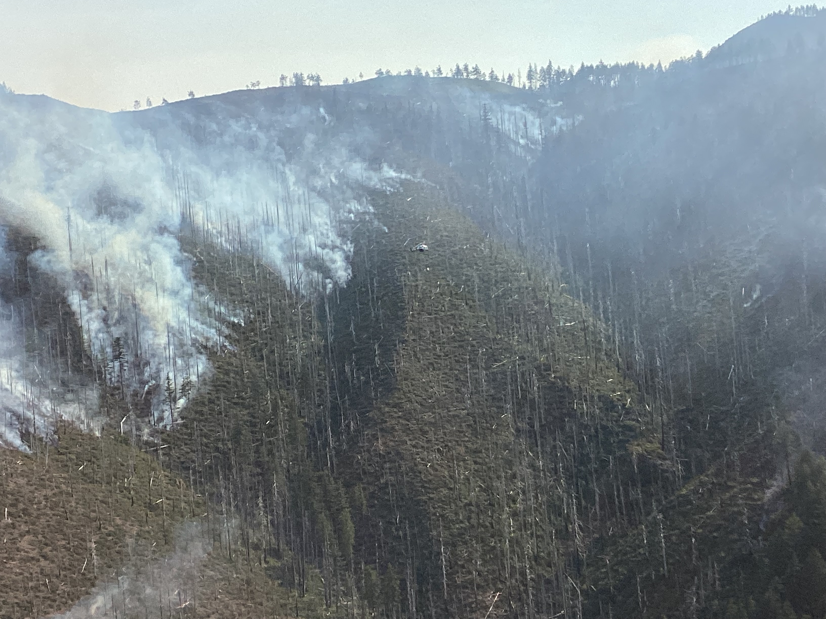
Fire backing down ridgeline during firing operations north of Game Lake
Thu, 08/03/2023 - 23:55
Fire backing down ridgeline during firing operations north of Game Lake. All aerial ignitions are within the fire perimeter. 8/3/2023
York Fire Evening Update for August 3 2023
Related Incident: 2023 - York Fire
Publication Type: News
Location: San Bernardino County, CA & Clark County, NV
Start Date: Friday July 28, 2023, at 12:09pm
Cause: Under Investigation
Size: 93,084 acres including 9,127 acres in Clark County, NV
Percent Contained: 63%
Vegetation: Timber (Litter and Understory), tall grass, and brush
Number of Personnel Assigned: 423
As of 6:00 pm August 3, the York Fire is at 94,009 acres with 63% containment. 9,127 acres are in Clark County, NV.
Firefighters worked hard last night and today, using minimal impact suppression techniques (MIST) to reduce heat on the fire’s perimeter. Crews focused their efforts on the northeast corner of the fire, where they observed persistent smoldering in juniper and pine woodlands. Hand crews attacked the fire directly and received assistance from helicopters that dropped buckets of water on hot spots.
Fire personnel continue to collaborate with resource specialists, known as “resource advisors” or “READs,” to implement MIST. READs have many specialties, including wildlife biology, plant ecology, archaeology, and geology. They work closely with fire crews to minimize the impacts of wildfire and of suppression activities.
Tonight will be the last night shift for firefighters, who will focus on patrolling for hot spots and monitoring cooled areas. Dry air and seasonal heat has filtered back into the region, bringing more challenging conditions for firefighters. Temperatures will in the mid-90s with single-digit humidity and gusty afternoon winds.
The joint effort to suppress the York Fire is a testament to the abilities of wildfire emergency resources. The involvement of the National Park Service, Bureau of Land Management, USDA Forest Service, California Department of Forestry and Fire Protection (CAL FIRE), San Bernardino County Fire Protection District, and Clark County Fire highlights the scale of the fire and the need for extensive resources to tackle it effectively.
York Fire staff are working closely with Clark County Communications to provide timely and accurate information to the public. If you have any questions regarding the residential areas of Nipton and Searchlight, please reference Clark County Public Communications or their Twitter at Clark County Nevada
WEATHER: Weather will become hotter, dryer, and windier this weekend.
EVACUATIONS: No current evacuations.
PARK & ROAD CLOSURES: Ivanpah Rd. between Morning Star Mine Rd and Cedar Canyon Rd., as well as all of Hart Mine Rd. are closed due to hazardous wildfire conditions and fire suppression operations. Mojave National Preserve is also under Extreme Fire Restrictions, please visit their website for more information on restrictions and closures: Alerts & Conditions - Mojave National Preserve . Please visit Road Conditions - Mojave National Preserve to view a detailed map of current park closures
Settings - change map background and toggle additional layers
Filter - control incident types displayed on map.
Zoom to your location
Reset map zoom and position
Could not determine your location.
Show Legend
 Wildfire
 Prescribed Fire
 Burned Area
Response
Burned Area
Response Other
Other
Crabapple Fire
Unit Information
Incident Contacts
Settings - change map background and toggle additional layers
Filter - control incident types displayed on map.
Zoom to your location
Reset map zoom and position
Could not determine your location.
Show Legend
- Wildfire
- Prescribed Fire
- Burned Area
Response
- Other
Laguna Larga Fire
Unit Information
Incident Contacts
West Hallett and West Anderson Fire Update 832023 Evening
Related Incident: West HallettWest Anderson
Publication Type: News
Cheney, WA, - The West Hallett Fire was reported at 1337 on Monday July 31st. It is located approximately 2 miles West of Highway 195 North of the Cheney Spokane Road.
Cheney, WA, - The West Anderson Fire was reported at 1708 on Wednesday August 2nd. It is located approximately ½ mile east of the city of Cheney North of Anderson Road.
Currently there are approximately 200 line and support personnel assigned to the fires.
The West Hallett fire is 75% contained and is sized at 126 acres. Evacuation levels are at level 1 (be ready to go) for residences within the fire perimeter. See attached map for clarification.
The West Anderson Fire is 0% contained and is sized at approximately 35 acres. There was a spot fire outside of the lines that burned into the main fire this afternoon. Acreage will change with the morning update. With the help of Air resources, crews were able to get the fire stopped and trailed into the main fire. Evacuation levels are at level 2 (Be set to go) for areas along Anderson road south of Cheney Spokane Road. See attached map for clarification.
Washington Department of Natural Resources and Spokane County Fire District 3 have assigned management of both fires to a Northeast Washington Interagency Type 3 Incident Management Team.
On West Hallett, firefighters continue to make progress toward the fire being 100% mopped up.
On West Anderson, Firefighters worked to stop the spot fire and enhance control lines around the fire while starting to mop up the perimeter.
Initial mop up is for 300 feet around all structures and 100 foot perimeter around the entire fire working towards 100% extinguishment.
The incident command post is located at the Cheney middle School in Cheney WA. Fire information contact is Eric Keller at 509-481-7064.
Actualizacin del Incendio Lowline Jueves 3 de Agosto 2023 900 pm
Related Incident: Lowline Fire
Publication Type: News
Equipo de Gestión de Incidentes del Complejo del área de las Montañas Rocosas 1
Dan Dallas, Comandante del Incidente
Teléfono de Información: 970-648-4470 (publico), 970-765-7123 (medios de comunicación)
Correo electrónico: 2023.lowline@firenet.gov
Horario: 8 a.m. – 8 p.m.
Situación Actual:
Las condiciones climáticas de hoy y el comportamiento moderado del fuego permitieron a los bomberos completar la línea de fuego en varias secciones, avanzando la contención al 54 %. En casi todas las divisiones, el trabajo incluyó recursos de extinción de incendios que construyeron líneas de fuego, patrullaron, limpiaron y extinguieron focos secundarios. Los bomberos continuarán trabajando sobre el éxito de los días anteriores para asegurar líneas de fuego a lo largo del perímetro y construir líneas de contingencia. Las líneas de fuego no contenidas siguen siendo la máxima prioridad.
En los próximos días, los bomberos permanecerán alertas a medida que el área entre en una tendencia de calentamiento y sequía. Se pronostica una vigilancia meteorológica de incendios para el domingo, lo que significa un mayor riesgo de peligro de incendio debido a los fuertes vientos, la baja humedad y las temperaturas cálidas.
División A: Se alcanzó una contención adicional en la División A donde se cruza con Middle Creek. Este drenaje húmedo aumenta la línea de fuego debido al agua disponible y al alto contenido de humedad en la vegetación adyacente. La ignición aérea no ocurrió hoy porque los combustibles no estaban lo suficientemente secos para quemarse al nivel necesario para reducir el potencial de incendio. Los administradores de incendios evaluarán las condiciones mañana por la mañana y pueden realizar una operación de quema aérea en bolsas interiores de combustible que aún no se han quemado. En otras partes de la división, la patrulla de línea de fuego y la limpieza continuaron.
División Z: Los bomberos buscaron fuentes de calor y las extinguieron totalmente. La contención aumentó en esta división, y toda la división ahora está completamente contenida.
División Y: Se han establecido líneas de fuego de contingencia en el borde de la cresta y más allá con una línea indirecta que conecta con el límite de la naturaleza. Los administradores de incendios no anticipan la necesidad de estas líneas de contingencia ya que una gran arboleda de álamos proporciona el descanso de combustible predominante. Las arboledas de álamos no han mostrado una susceptibilidad al comportamiento del fuego exhibido en los rodales de árboles de coníferas. Se han establecido varios puntos de aterrizaje de helicópteros en los últimos días para brindar acceso en el lado oeste. Estos helipuntos respaldan las necesidades logísticas operativas y de bomberos, incluidos alimentos, agua, suministros y reconocimiento aéreo. También permiten una extracción médica rápida en caso de que sea necesario.
División X: esta división sigue sin tener personal de bomberos que realicen trabajos de supresión, aunque los administradores de incendios continúan evaluando los próximos pasos a través de misiones de exploración y el uso de tecnología.
División W: El trabajo continuó en las líneas de fuego primarias y secundarias con los bomberos conectando varias praderas húmedas como parte del desarrollo de la línea de fuego indirecta. Estas líneas de contingencia proporcionan una línea secundaria de defensa para mantener el fuego dentro del perímetro actual. En caso de que se necesiten acciones adicionales, los bomberos han identificado la capacidad de realizar operaciones de quema de ensanche con poca anticipación, si el clima lo permite, porque el trabajo de preparación está completo. Los bomberos buscaron puntos calientes y los extinguieron en otras partes de la división.
Protección de Estructuras: Las evaluaciones de protección de estructuras están completas en las casas localizadas en Mill Creek. Los bomberos continuarán con estos esfuerzos en todas las casas cercanas al incendio, centrándose actualmente en las estructuras al norte del incendio. Se han completado 125 evaluaciones de estructuras en todo el incendio.
Condiciones Climáticas y de Combustible:
Con un clima más caliente y seco y ráfagas de viento por la tarde, los combustibles se están secando a un ritmo acelerado. Estas condiciones apoyarán un comportamiento del fuego más activo y una propagación más fácil del fuego donde los combustibles son densos en el interior. El clima cálido y seco con vientos racheados por la tarde continuará durante los próximos días. Mañana, las temperaturas serán un poco más cálidas a mediados de los 70, la humedad en el rango bajo del 30% y los vientos de 5 a 10 mph con ráfagas por la tarde.
Evacuaciones, Cierres, y Restricciones de Incendios:
Se han realizado evacuaciones obligatorias en los drenajes de Squirrel Creek y Mill Creek. Para obtener información específica sobre evacuación, consulte Manejo de emergencias del condado de Gunnison en www.gunnisoncounty.org. Puede registrarse para recibir alertas de emergencia en sus teléfonos u otros dispositivos en: https://bit.ly/3QhZVZg.
Se ha implementado cierre de áreas, caminos y senderos en tierras del Sistema Forestal Nacional cerca del incendio. Para obtener detalles, consulte este enlace: https://www.fs.usda.gov/Internet/FSE_DOCUMENTS/fseprd1126172.pdf. BLM ha implementado un cierre temporal en la vecindad del incendio. Para obtener más información, consulte este enlace: www.blm.gov/programs/public-safety-and-fire/fire-and-aviation/regional-information/colorado/southwest-district. Las carreteras del condado en la vecindad del incendio están bloqueadas. En interés de la seguridad pública, los bomberos piden a los visitantes que estén atentos al tráfico de incendios y que eviten el área.
Actualmente no hay restricciones de incendios en el condado de Gunnison. Si se implementan restricciones, se publicarán en este sitio: https://westslopefireinfo.com/gunnison-county/.
Reportes diarios sobre la perspectiva de humo se encontrar en el siguiente enlace:https://outlooks.airfire.org/outlook/ed63b240.
Los incendios forestales son una zona de exclusión aérea para aeronaves no autorizadas, incluidos los drones. Si tu vuelas, nosotros no podemos. Para obtener más información, visite http://knowbeforeyoufly.org.
Estadísticas del Incendio Lowline:
Tamaño: 1771 acres
Contenido: 54%
Personal: 393
Locación: 14 mi. NNW de Gunnison, CO
Reportado: 8:00 am 26 de Julio, 2023
Causa: Relámpago
Para más Información:
Línea Telefónica: 970-648-4470 (publicó), 970-765-7123 (media)
Correo electrónico: 2023.lowline@firenet.gov
InciWeb: https://inciweb.wildfire.gov/incident-information/cogmf-lowline-fire
Facebook: www.facebook.com/GMUGFireInfo