
Daily Update Ridge Fire August 4 2023
Related Incident:
Publication Type: News
NORTHERN ROCKIES TEAM 9 INCIDENT COMMANDER: SHANE MARTIN
Ridge Fire
Flathead National Forest, Hungry Horse Ranger District
Fire Information 406-998-6074 2023.ridge@firenet.gov
https://inciweb.nwcg.gov/incident-information/mtfnf-ridge-fire
August 4, 2023
Location: 6 miles southeast of Hungry Horse, MT
Start Date: 7/30/23 Cause: Lightning Size: 1576 acres Containment: 0%.
Total Personnel: 90 Dozers: 2 Hand Crews: 3 Water Tenders: 2
KEY MESSAGE
To provide for public and firefighter safety, FS Road 38 (East Side Road) is closed to all public traffic at the junction of FS Road 497 (Desert Mountain Road) and FS Road 38. Mandatory Evacuation Notice is in effect for all public traffic east of junction of FS Road 38 and FS Road 497.
CURRENT SITUATION
Active fire behavior on the southeast corner and it crossed FS Road 38 and the Emery Creek drainage. An overnight infrared flight determined the acreage at 1576 acres, an increase of 943 acres. Yesterday, there was minimal fire growth on the west side of the fire towards the private properties and communities. Additional fire personnel and equipment have been arriving and are being integrated into fire operations.
Yesterday, crews were working to create a fuel break on FS Road 38. Helicopters provided water bucket drops over the fire area from impacting critical infrastructure such as private property and FS Road 38. Heavy equipment was utilized to create a fuel break on the west side of the fire to limit fire spread onto private property, Coram and Martin City.
Today, resources will continue prioritizing firefighting efforts on the west side of the fire. Hand crews are working on creating a fuel break along FS Road 38. Heavy equipment are implementing a fuel break on the west side of the fire to protect private property and the communities of Coram and Martin City. This is a full suppression fire and firefighter and public safety is the top priority. Aerial resources will be utilized as needed to prevent fire from negatively impacting firelines and values at risk.
WEATHER AND FIRE BEHAVIOR
Hot and dry conditions are expected to remain today with light winds (10 mph). Thunderstorms and precipitation is expected to arrive Friday night which may produce gusty winds up to 30 mph. This could cause fire behavior to shift to the west. The fire is actively burning on all sides in steep terrain with heavy dead and down fuels and mostly move south and east. Smoke is visible from locations along Highway 2 mainly between Columbia Falls and West Glacier.
CLOSURES AND SPECIAL MESSAGES
The Flathead National Forest implemented an area closure for the area impacted from the Ridge Fire. Please visit Inciweb for more information.
Lowline Fire Evacuations Update
Related Incident: Lowline Fire
Publication Type: Announcement
From Gunnison County 911:
Previous evacuation order rescinded.
After many discussions with fire personnel and taking into consideration the current stage that the fire is in, it has been determined that the previous evacuation order regarding the Lowline Fire in the Mill Creek drainage area, (CR 727) of Gunnison County Colorado will be rescinded as of noon on today's date, (08-04-23). This area WILL REMAIN in a pre-evacuation condition, likely for the duration of this fire. County road 727 will remain closed to all people except homeowners, people living there and people working in the area.
The closures at County Road 7 and at Kebler Pass, (CR 12) on County Road 730 will remain in place for local traffic only. Please remember that there are still closures to all people on the Forest and BLM lands in the area.
***
For additional evacuation information, visit the Gunnison County Regional 911 Center on Facebook at: https://www.facebook.com/Gunnison911/ or call
August 4 Daily Update
Related Incident: Eagle Bluff
Publication Type: News
TONASKET, Wash. August 4, 2023 – The Eagle Bluff fire is now at 16,428 acres and is 45% contained. Management objectives continue to focus efforts on firefighter safety, public safety, protection of property, and preservation of cultural and natural resources values. The fire is burning on land managed by the Washington Department of Natural Resources and the Spokane District—Bureau of Land Management west of Oroville, Wash.
Yesterday, crews continued to monitor and secure the perimeter along the eastern flank of the fire and provide support in structure protection. Interior flare-ups of unburned fuels may be visible, especially at night, but pose little danger of spread. To the south, firefighters made efforts to control existing features and had support from aircraft on the interior of the fire. On the western perimeter, Rogue River Interagency Hotshots worked to establish direct line south of the Similkameen River.
Today, on the eastern and southern perimeter crews will repair dozer lines and make further evaluation of needed repairs. To the northwest, hand crews and Rogue River Interagency Hotshots will make continued efforts to establish direct line to Similkameen River. Fire personnel will be patrolling the Canadian border on established dozer line for fire monitoring. Throughout night operations, fire personnel will continue to grade roads, control established line, and respond to calls.
WEATHER: Hot dry weather is expected again today. A ridge of high pressure is slowly making its way north bringing some moisture and a slight chance of isolated thunderstorms to the region. Chances of precipitation will increase tomorrow and into the weekend bringing more clouds and potential for precipitation.
SAFETY: The combination of very dry fuels and low humidity has the potential for active fire behavior. It is important that everyone use caution to reduce the risk of wildfires. Make sure chains are not dragging on trailers, know what the current restrictions on burning are in effect, and do your part to reduce the risk of new fire starts.
SMOKE: The fire produced a lot of smoke yesterday, especially on the Canadian side of the border. Northern winds will persist, bringing smoke into the region. Reduced air quality is expected with fair to moderate visibility into the afternoon hours. Conditions may improve with some air mixing as temperatures rise, but smoke may settle into the interior valleys.
The British Columbia Wildfire Service is overseeing the fire on the Canadian side. For more information, please visit the Canadian Wildland Fire Information System at https://cwfis.cfs.nrcan.gc.ca/home.
Evacuation levels have decreased in Okanogan County, but some road closures remain in place. For up-to-date information on wildfire closures and evacuations, follow Okanogan County Emergency Management at https://okanogancounty.org/government/emergency_management/
Spoon Fire Daily Update August 4 2023
Related Incident: Spoon Fire
Publication Type: News
Firefighters Efforts Make Significant Headway in Fire Containment
Cottonwood Ridge, Snake Ridge, Spoon and New Fire Starts – August 4, 2023, Daily Update
Spoon Fire Quick Facts
Acres: 4,560 acres
Cause: Lightning
Containment: 45%
Start Date: July 24, 2023
Location: 2.5 miles east of Highway 60 between Globe and Show Low, AZ. 11 miles southwest of Cedar Creek
Fuels: Piñyon- Juniper, Manzanita, Grass, Cedar
Total personnel for all incidents: 407
On Thursday, heat sources along fire containment lines continued to decrease, meaning the heat is naturally diminishing adjacent to the fire containment lines. This allows firefighters to work steadily to increase containment on all fires.
New fire starts addressed Wednesday showed minimal heat and no smoke on Thursday. Although the temperature was warm, dry, and breezy, no additional new starts were detected.
Today, crews will continue to scout out and ensure there are no remaining heat sources along containment lines, begin repair work, reestablish jeep trails and roads and redirect water off roads and trails. While there has been a significant leap towards containment of all large fires, firefighters will continue to be ready to respond to any new starts.
Spoon Fire Update: Fire crews scouting the north edge of the fire containment lines found minimal heat sources Thursday. Crews will begin assessing repair work needed and continue patrolling the fire perimeter for hot spots. Firefighters and equipment will begin repairing dozer and hand lines, and redirect water off roads and trails. Diligent efforts by firefighters increased containment by another 10%, bringing containment on the Spoon Fire up to 45%.
Weather: Hot weather in the low 90s, dry fuels and high wind gusts of 25 miles per hour are a concern into the weekend, but firefighters will remain prepared to respond to any new fire starts.
Evacuations: None.
For awareness regarding evacuations, familiarization with the Ready, Set, Go evacuation model is encouraged. Community members may also sign up for the Navajo County Alert System at https://tinyurl.com/y4vwrasw.
Smoke: Smoke is very minimal, but may still be visible as pockets of heat continue to subside. For information on smoke and air quality, visit https://www.airnow.gov.
Closures: Highway 60 remains open. The southwest portion of Fort Apache is closed, including all Salt River sites within the closure area.
Fire Restrictions: There are several fire restrictions in place depending on location.
- Fort Apache Agency: Stage 2 Fire Restrictions
No campfire, fireworks, outdoor smoking, debris burning or discharging of firearms. Power saws cannot be used between 10 am and 8 pm. All motorized travel is restricted to developed roads. - Show Low, Navajo County and Apache Sitgreaves National Forests: Stage 1 Fire Restrictions
No campfires (except in developed recreation sites), no smoking outdoors, no welding, no fireworks.
More Information:
InciWeb:
- Cottonwood Ridge: https://inciweb.nwcg.gov/incident-information/azfta-cottonwood-ridge-fire
- Spoon: https://inciweb.nwcg.gov/incident-information/azfta-spoon-fire
Facebook: https://www.facebook.com/BIAFAAFireMgt/
Flat Fire Morning Update 8042023
Related Incident: Flat Fire
Publication Type: News
August 4, 2023
Flat Fire Morning Update
Size: 31,921 acres
Start Date: July 15, 2023
Point of origin: 2 miles southeast of Agness, OR
Containment: 28%
Cause: Human caused
Total personnel: 1,092
Resources: 38 engines l 16 crews l 1 bulldozer l 31 water tenders l 4 masticators l 9 helicopters
Current Situation: In the southwest corner of the fire in Lawson Creek drainage and in the Game Lake area, helicopters had excellent success with continued aerial ignition achieving additional depth from the containment line further into the unburned interior. A helitorch was also utilized near the headwaters of Lawson Creek to improve fuels consumption in the brush and shrub vegetation. A 10-person helitack crew (a firefighting crew flown in by helicopter) returned to the Fantz Ranch area along the eastern edge of the fire to cool areas of heat identified through infrared photography/imaging and eliminate dangerous hazard trees. This is helping to slow movement further east.
Firefighters used helicopter water bucket drops on areas of heat in the north fork of Indigo Creek to secure the containment line. Crews mopped up areas of heat close to the containment line in the NE corner of the fire (at the end of Forest System Road 150). Firefighters worked to improve alternate containment lines (re-routed a stretch of fireline by constructing a handline) and prepared a firing plan in the northeast corner of the fire, should a future need arise to burn this area due to changes in weather conditions or fire activity.
Structure protection resources focused on inventory of structures and fuels reduction at the Agness Guard Station. An overall structure protection plan to aid firefighters in protecting structures in the area if there is a future need is nearing completion. The alternate control lines on Forest System Roads (FSR) 1376 (to the south) and 1503, 3313, and 3680 (to the west) continue to be improved. Night-shift resources held and patrolled fireline.
Today’s activities: Aerial ignition efforts over the past several days to gain additional fireline depth between the western and eastern portions of FSR 3680 in the Lawson Creek drainage (southwestern corner of the fire) is largely complete. Fuels are still drying and discontinuous in some locations and the fire will continue to move through islands of vegetation in the coming days. Additional aerial burning will be used to fill in non-contiguous areas of unburned fuel and provide additional depth. Firefighters will work today to hold, secure, improve and mop up the containment line along FSR 3680. Aerial interior burning will also continue in the Game Lake area. The western and northern containment lines, from the junction of FSR 3680 and 3318 to Wildhorse Lookout east to FSR 3577, is being actively mopped up and patrolled.
With fire traffic on Bear Camp Road, all motorists on Bear Camp Road are asked to slow down, use headlights and proceed with caution.
Leadership provided by the Pacific Northwest (Type 1) Incident Management Team 3 is nearing the end of its 14-day rotation and will be replaced by Northern Rockies (Type 1) Incident Management Team 2 effective at 6:00 a.m. on Saturday, August 5. Today is a day of “shadowing” and transferring intelligence to the new incident management team. Fire personnel and resources will remain in place during the transfer of command.
Evacuations: All remaining evacuation levels are now at Level 1 “Get Ready” evacuation status for all areas in the vicinity of the Flat Fire. The Curry County Sheriff’s Office will continue to coordinate with the Fire Incident Management Team and will notify all residents affected by the fire of any reasons to change evacuation levels. Curry County is using Everbridge to send evacuation notices. You can sign up for notifications here: https://www.co.curry.or.us/departments/emergency_management/index.php.
Weather: With a drier air mass moving over the area, temperatures will continue to increase and relative humidity will decrease through the weekend. The period of daily low humidity is increasing with this predicted weather resulting in drier fuels and possible increased fire behavior.
Smoke: The Smoke Outlook is available at: https://outlooks.airfire.org/outlook/b74901f7
Closures: The Rogue River-Siskiyou National Forest (RRSNF) has issued a closure order for the fire area including trails, roads and a portion of the Illinois River. Oak Flat Campground, Game Lake and Wild Horse Campgrounds and Snow Camp Lookout Recreation Rentals are all closed as part of the area closure. The Chetco River Road (FSR 1376) and Chetco/Pistol River Road (FSR 1407) are now closed. The updated closure allows for public access to the Big Rock swimming hole on the Illinois River.
Restrictions: Fire danger is currently extreme; the RRSNF is implementing Level 2 Public Use Restrictions beginning today, August 4. More information can be found here: https://tinyurl.com/ueuznr6e
Please follow all fire restrictions to prevent wildfires. Know before you go. Check on whether there are any campfire restrictions at your recreation destination.
Cottonwood Ridge Update August 4 2023
Related Incident: Cottonwood Ridge Fire
Publication Type: News
Firefighters Efforts Make Significant Headway in Fire Containment
Cottonwood Ridge, Snake Ridge, Spoon and New Fire Starts – August 4, 2023, Daily Update
Cottonwood Ridge Fire Quick Facts
Acres: 345
Cause: Lightning
Containment: 90%
Start Date: July 23, 2023
Location: 4 miles south of Show Low, AZ
Fuels: Timber, grass, brush
Snake Ridge Fire Quick Facts
Acres: 42 acres
Cause: Lightning
Containment: 100%
Start Date: July 28, 2023
Location: 11 miles southwest of Show Low, AZ.
Fuels: Grass, Brush
Total personnel for all incidents: 407
On Thursday, heat sources along fire containment lines continued to decrease, meaning the heat is naturally diminishing adjacent to the fire containment lines. This allows firefighters to work steadily to increase containment on all fires.
New fire starts addressed Wednesday showed minimal heat and no smoke on Thursday. Although the temperature was warm, dry, and breezy, no additional new starts were detected.
Today, crews will continue to scout out and ensure there are no remaining heat sources along containment lines, begin repair work, reestablish jeep trails and roads and redirect water off roads and trails. While there has been a significant leap towards containment of all large fires, firefighters will continue to be ready to respond to any new starts.
Cottonwood Ridge Fire Update: Crews will continue to patrol firelines for any remaining heat sources and begin suppression repair work along dozer lines to restore the containment line to a more natural state. Firefighters worked hard to increase containment by 25%, reaching 90% containment on the Cottonwood Ridge Fire Thursday.
Snake Ridge Fire Update: Crews patrolled the perimeter of the Snake Ridge Fire and didn’t find any heat sources close to the fireline, so were able to declare the fire 100% contained.
Weather: Hot weather in the low 90s, dry fuels and high wind gusts of 25 miles per hour are a concern into the weekend, but firefighters will remain prepared to respond to any new fire starts.
Evacuations: None.
For awareness regarding evacuations, familiarization with the Ready, Set, Go evacuation model is encouraged. Community members may also sign up for the Navajo County Alert System at https://tinyurl.com/y4vwrasw.
Smoke: Smoke is very minimal, but may still be visible as pockets of heat continue to subside. For information on smoke and air quality, visit https://www.airnow.gov.
Closures: Highway 60 remains open. The southwest portion of Fort Apache is closed, including all Salt River sites within the closure area.
Fire Restrictions: There are several fire restrictions in place depending on location.
- Fort Apache Agency: Stage 2 Fire Restrictions
- No campfire, fireworks, outdoor smoking, debris burning or discharging of firearms. Power saws cannot be used between 10 am and 8 pm. All motorized travel is restricted to developed roads.
- Show Low, Navajo County and Apache Sitgreaves National Forests: Stage 1 Fire Restrictions
- No campfires (except in developed recreation sites), no smoking outdoors, no welding, no fireworks.
More Information:
Inciweb:
- Cottonwood Ridge: https://inciweb.nwcg.gov/incident-information/azfta-cottonwood-ridge-fire
- Spoon: https://inciweb.nwcg.gov/incident-information/azfta-spoon-fire
Facebook: https://www.facebook.com/BIAFAAFireMgt/
York Fire Daily Update for August 4 2023
Related Incident: 2023 - York Fire
Publication Type: News
Location: San Bernardino County, CA & Clark County, NV
Start Date: Friday July 28, 2023, at 12:09pm
Cause: Under Investigation
Size: 93,078 acres including 9,127 acres in Clark County, NV
Percent Contained: 85%
Vegetation: Timber (litter and Understory), tall grass, and brush
Number of Personnel Assigned: 423
As of this morning August 4, the York Fire is at 93,078 acres with 85% containment. 8,352 acres are in Clark County, NV.
Firefighters worked last night using minimal impact suppression techniques (MIST) to reduce heat on the fire’s perimeter. Crews focused their efforts patrolling for hot spots and monitoring cooled areas.
Land managers and fire personnel continue to collaborate with natural and cultural resource specialists, known as “resource advisors” or “READs,” to implement MIST. READs have many specialties, including wildlife biology, plant ecology, archaeology and geology. They work closely with fire crews to minimize the impacts of wildfire and of suppression activities.
Last night was the last night of the night shift. Firefighters remain and will assist ground crews in suppressing any remaining heat. Dry air and falling humidity has filtered back into the region, bringing more challenging conditions for firefighters. Air support is available if needed.
The joint effort to suppress the York Fire is a testament to the abilities of wildfire emergency resources. The involvement of the National Park Service, Bureau of Land Management, USDA Forest Service, California Department of Forestry and Fire Protection (CAL FIRE), San Bernardino County Fire Protection District, and Clark County Fire highlights the scale of the fire and the need for extensive resources to tackle it effectively.
York Fire staff are working closely with Clark County Communications to provide timely and accurate information to the public. If you have any questions regarding the residential areas of Nipton and Searchlight, please reference Clark County Public Communications or their Twitter at Clark County Nevada
WEATHER: Temperatures will in the mid-90s with single-digit humidity and gusty winds.
EVACUATIONS: No current evacuations.
PARK & ROAD CLOSURES: Ivanpah Rd. between Morning Star Mine Rd and Cedar Canyon Rd., as well as all of Hart Mine Rd. are closed due to hazardous wildfire conditions and fire suppression operations. Mojave National Preserve is also under Extreme Fire Restrictions, please visit their website for more information on restrictions and closures: Alerts & Conditions - Mojave National Preserve . Please visit Road Conditions - Mojave National Preserve to view a detailed map of current park closures.
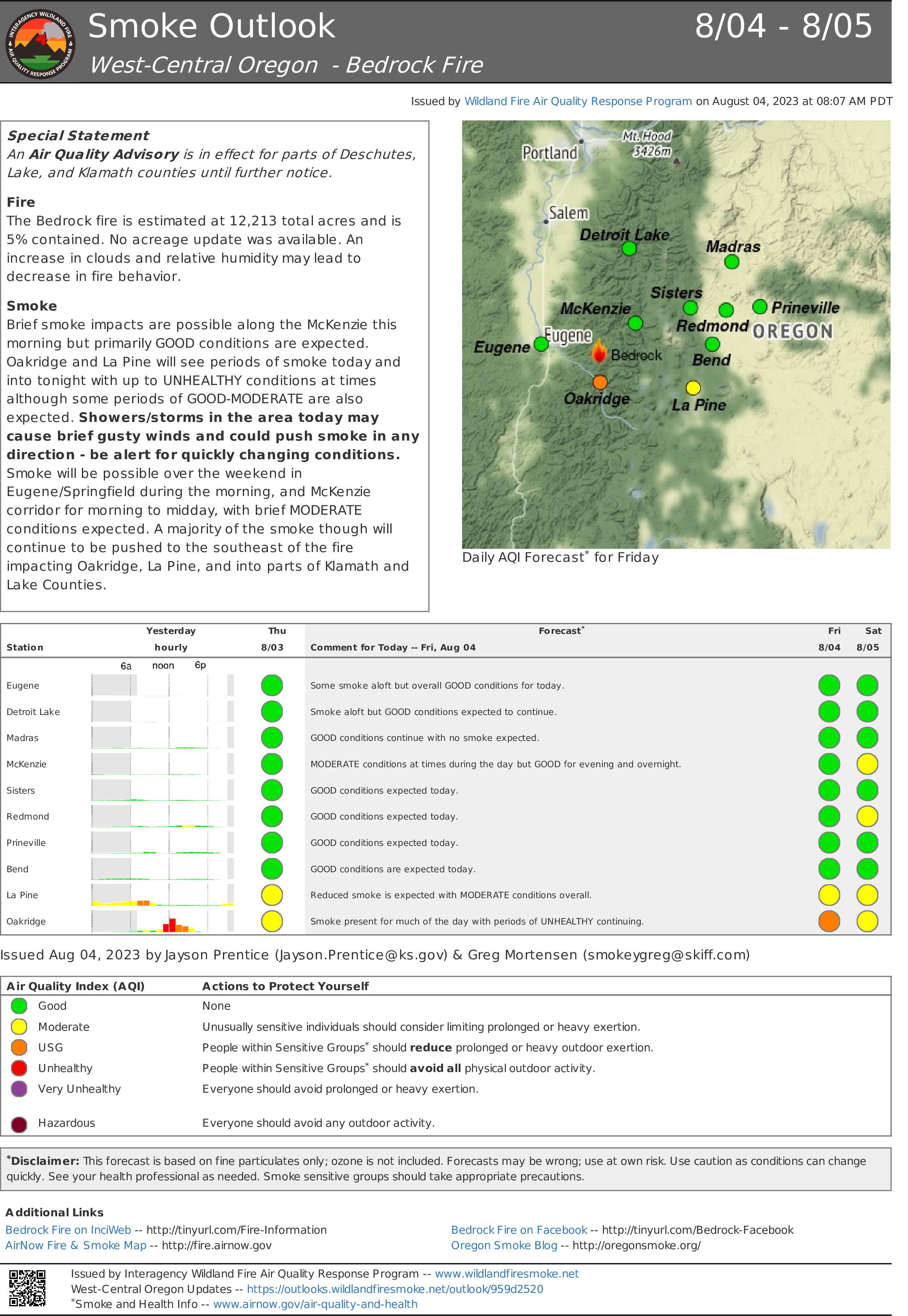
Smoke Outlook for August 4 5 2023
Related Incident: Bedrock Fire
Publication Type: News
The Bedrock fire is estimated at 12,213 total acres and is 5% contained. No acreage update was available. An increase in clouds and relative humidity may lead to decrease in fire behavior.
Brief smoke impacts are possible along the McKenzie this morning but primarily GOOD conditions are expected. Oakridge and La Pine will see periods of smoke today and into tonight with up to UNHEALTHY conditions at times although some periods of GOOD-MODERATE are also expected. Showers/storms in the area today may cause brief gusty winds and could push smoke in any direction - be alert for quickly changing conditions.
Smoke will be possible over the weekend in Eugene/Springfield during the morning, and McKenzie corridor for morning to midday, with brief MODERATE conditions expected. A majority of the smoke though will continue to be pushed to the southeast of the fire impacting Oakridge, La Pine, and into parts of Klamath and Lake Counties.
Sourdough Fire Daily Update August 4 2023
Related Incident:
Publication Type: News
2023.Sourdough@firenet.gov
360-370-4169
https://inciweb.nwcg.gov/incident-information/warlp-sourdough-fire
Fire Size: 534 Containment: 0% Personnel: 163 Helicopters: 3
The Sourdough Fire is being managed by the Southern Area Gray Incident Management Team. Mitch Ketron is the Gray Team Incident Commander.
This is a no-drone zone. This is a no-drone zone. Unauthorized drone flights (UAS) pose serious risks to firefighter and public safety and the effectiveness of wildfire suppression operations. Aerial firefighting is suspended when unauthorized UAS are in the area, allowing wildfire to grow larger.
Yesterday’s Activities: Yesterday’s Activities: There was significant fire growth along the southern edge of the fire downhill to Diablo Dam Road, and to the northeast toward Sourdough Creek, due to hot, dry, and windy conditions. Helicopters were used extensively, dropping water to slow fire spread. Fire personnel were actively engaged in structure protection, triage, and preparation based on fire location and behavior, which included setting up hose lays, sprinkler systems, and preparing structures in the town of Diablo.
Today: Fire personnel will continue to focus on structure protection efforts in Diablo and the Environmental Learning Center, as well as scout and identify possible fire containment lines. Crews will assess structures and park infrastructure in the Ross Lake area for structure protection. Helicopter water drops will continue in an effort to slow fire spread and downhill fire due to terrain-influenced roll-out. Terrain is extremely steep, rugged, and inaccessible. Increased fire behavior is possible today with continued hot, dry, and windy conditions..
Weather: Sunny, with a high near 82. Variable winds expected today, becoming west between 6 and 9 mph. Low humidity in the range of 30-35%. Take caution when recreating outdoors when smoke is present. Learn more at https://wasmoke.blogspot.com
Area/Road Closures & Evacuations -EVACUATIONS- Evacuations are in effect for North Cascades Environmental Learning Center. There is no access across Diablo Dam until further notice. Trail, area, and camp closures are in effect due to fire activity. Closure information can be found at https://www.nps.gov/noca/planyourvisit/fire-closures.htm.
Bowles Creek Fire Update for August 4th 2023
Related Incident: Bowles Creek Fire
Publication Type: News
CURRENT SITUATION & PLANNED ACTIONS
Heavy equipment and masticators continue improving and constructing indirect fuel break (by clearing dead and down vegetation) along Forest Road 711A towards Railroad Creek, and on Forest Road 5071 towards Forest Road 5070. Firefighters improved and successfully held control line as easterly winds shifted fire towards the line. Fire personnel will continue scouting for containment opportunities to the North and South, including the use of previous firelines from the 2022 Hog Trough Fire.
On the west side of the fire, hose lay and sprinklers are still being used by hand crews to support suppression efforts. A corduroy bridge was built near Crystal Creek Campground for heavy equipment to cross and prevent streambed impacts. A corduroy bridge is made by placing logs, perpendicular to the direction of the route. Fire personnel are addressing various spot fires towards the south. Helicopters to support operations on both ends of the fire area .
WEATHER AND FIRE BEHAVIOR
Cooler temperatures and higher humidity is forecasted, with precipitation moving in for the weekend. There is potential for thunderstorm development.
Smoke may be visible from various fires in the region, for more information visit www.airnow.gov or www.montanawildfiresmoke.org.
CLOSURES
The Beaverhead-Deerlodge National Forest and Bitterroot National Forest issued an emergency closure of roads and trails (Closure #02-08-23-19) effective July 25, 2023. This Order is for public and firefighter safety during fire suppression efforts of the Bowles Creek Fire. See the following link for a complete listing of the roads and trails listed in the closure: https://www.fs.usda.gov/alerts/bdnf/alerts-notices/?aid=81818. Closure information and maps are posted on the Forests’ website and the fire’s Inciweb page as they are in place.
The Skalkaho Pass Road remains open. Those recreating or traveling in the fire area are encouraged to be aware of the situation and reduce speed due to increased fire traffic.