
Crabapple Fire Daily Update 08052023
Related Incident: Crabapple Fire
Publication Type: News
Crabapple Fire Update
Friday August 5, 2023
8:00 am
Size: 56 acres
Containment: 100%
Start Date: August 3, 2023
Cause: Under Investigation
On Thursday August 3rd, Texas A&M Forest Service (TAMFS) received a request for assistance on a fire approximately 6 miles west of Blanco, Texas. Texas A&M Forest Service responded around 4:15 pm, providing personnel, dozers and air operation assistance to the local fire department. The Texas Emergency Medical Task Force from Kerrville and Texas Intrastate Fire Mutual Aid System Strike Team (TIFMAS) arrived on scene at approximately 5:30pm to offer additional crews and medical assistance if needed. The fire is currently 56 acres in size burning through grass and timber near 19 structures.
Yesterday:
Texas A&M Forest Service resources arrived back on scene by 9:30 am. The Crabapple Fire experienced good relative humidity recovery overnight and local crews monitored and provided heat suppression, there was no change in fire behavior. Through the day, dozers continued improving containment lines and suppressing heat in the areas where the single engine air tanker (SEAT) dropped retardant on August 3rd. Engine and ground crews patrolled and sprayed hot areas where needed. By 7:00pm, containment had increased to 100% and command was transitioned back to Blanco County Fire Department by 8:00pm.
Evacuations: None
Damages/Injuries: 19 threatened structures, two were directly saved and none lost
Closures: None
Hayden Fire Update August 5 2023
Related Incident:
Publication Type: News
Firefighting resources are making good progress on the Hayden Fire. The fire's growth remains minimal with rain assisting across the fire. Incident meteorologists expect continued precipitation over the weekend but are forecasting winds and heat to return early next week which may increase fire activity.
If you live near or are visiting the Pahsimeroi Valley this weekend, please note that smoke may become visible due to activity on the southern edge of the fire.
Fire crews continue to secure the line along the western perimeter of the fire in Kadletz Creek. They are also making progress with containment lines along the east side of the fire and planning repair work. In close coordination with Salmon-Challis National Forest archaeologists, a hydrologist, and local landowners, crews will build water bars, which divert water and reduce damage from erosion, to preserve the fireline’s integrity and protect local resources.
Evacuations: The Lemhi County Sheriff’s Office, in coordination with the local agencies and incident management team have pre-identified evacuation zones. The evacuation status is continuously evaluated and will be lifted when officials determine it is safe to do so. Please visit the Lemhi County website at www.lemhicountyidaho.org for a map and explanation of the zones.
Smoke: Air quality has been impacted by regional fires to the West. A smoke outlook specific to the Hayden Fire vicinity can be found at www.bit.ly/haydensmoke.
Closures: For the safety of firefighters and the public, the Salmon-Challis National Forest has enacted an area closure around the Hayden Fire. A map and description of the closure area can be found at https://inciweb.wildfire.gov/incident-closures/idscf-hayden-fire.
Fire Restrictions: Stage 1 Fire Restrictions are in effect in areas managed by the Salmon-Challis National Forest, Idaho Department of Lands, and the Bureau of Land Management. For more information, please consult Salmon-Challis National Forest’s Alerts and Notices at https://www.fs.usda.gov/alerts/scnf/alerts-notices.
Ridge Fire Public Meeting 2 PM Saturday August 5 Hungry Horse Volunteer Fire Department
Related Incident:
Publication Type: Announcement
A public meeting will be held at 2 pm on Saturday, August 5 at Hungry Horse Volunteer Fire Department, 145 Hungry Horse Blvd, Hungry Horse, MT. Incident Management Team members and local officials will provide an update on the Ridge Fire. Please join us. Thank you.
84 Flat Fire Update on Todays Activities
Related Incident: Flat Fire
Publication Type: News
August 4, 2023
Flat Fire Update
Today’s Activities: Firefighters were again successful today with aerial ignitions burning out to increase fireline depth near Game Lake and in the southeast corner of the fire, generating smoke in both areas. Crews continue to hold and improve fireline along the fire’s edge in between those two areas along the southeastern edge of the Flat Fire, while firefighters on the western side of the fire carefully sought out and cooled any areas of heat. Structure protection crews continued work to record structure information for future protection needs, and work groups including Coos Forest Protective Association crews continued to prepare roads working toward Snow Camp for an alternate containment line. Night shift resources will continue work overnight.
Aerial Overview of the Flat Fire: August 04, 2023
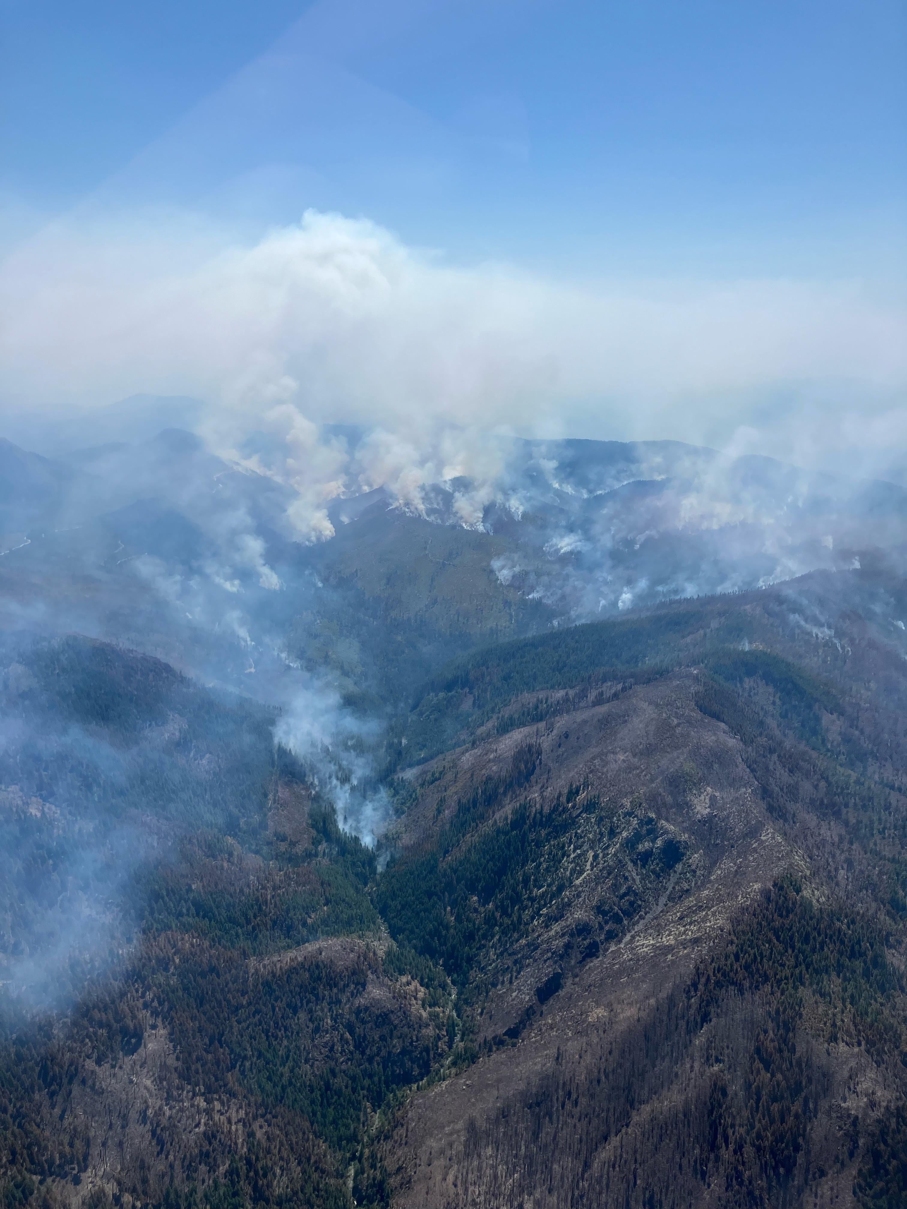
Sat, 08/05/2023 - 00:20
An aerial overview of the Flat Fire. Taken August 4, 2023 by PNW3.
Sourdough Fire Evening Update August 4 2023
Related Incident:
Publication Type: News
Sourdough Fire Evening Update August 4, 2023
At 3:00 PM, the fire inversion lifted, which caused an increase in fire activity (and growth) approximately one hour later. The fire growth included westward to along Stetattle Creek, upslope towards Bucket Creek, and crossing Stetattle Creek; eastward towards Sourdough Creek and Sourdough Creek drainage, and northward towards the top of Sourdough Mountain. Structure preparation, including wrapping, is complete at the historic Sourdough Lookout.
Structure protection efforts around the Diablo Community, were implemented successfully. The Sourdough Fire has backed down to Diablo Dam Road, most of the way to the Environmental Learning Center (ELC).
Structure protection measures continue at the Environmental Learning Center and eastward towards Buster Brown Boat-in Camp. Hose lays and sprinklers were set up and crews are monitoring the area. Diablo Dam Road and Diablo Road remain closed. Structure protection assessments from Diablo westward towards Newhalem, along State Road 20 started today and will continue tomorrow. Assessments from Ross Dam eastwards Big Beaver Creek started today and will continue tomorrow.
Aviation resources were used extensively to limit fire spread between 3:00 PM and sunset once the inversion lifted and it was safe for air operations.
Additional resources arrived on-scene to bolster the firefighting effort.
State Road 20 will be closed beginning at 10:00 PM Friday night, between Mile Markers 120-156.
The estimated size of the Sourdough Fire is estimated at 2,933 acres.
With the current dry conditions and anticipated weather, another active fire day is anticipated for tomorrow.
842023 Ridge Creek Fire Evening Update and Closure
Related Incident:
Publication Type: News
Ridge Creek Fire
Idaho Panhandle National Forests, Coeur d’Alene River Ranger District
Fire Information 208-557-8813
https://inciweb.nwcg.gov/incident-information/idipf-ridge-creek
August 4, 2023
Location: Approximately 3.5 miles east of the north tip of Hayden Lake, along the Hayden Creek Road (FSR 437) in the Ridge Creek drainage
Start Date: 8/3/2023
Cause: Under Investigation
Size: 300-400 acres
Containment: 0%
Total Personnel: 50
Engines: 3
Dozers: 2
Hand Crews: 1
A Type 3 Incident Management Team will take command of the fire at 6 AM tomorrow morning. The fire is burning in snags and dense vegetation, making construction of handline difficult. Crews have anchored off FSR437 and are working on the west side of the Ridge Creek drainage. Fire activity is most active on the eastern flank, in Hells Canyon, creating spot fires that have filled in. Air resources from Missoula and Coeur d’Alene assisted during much of the day. The fire is estimated at 300-400 acres; an IR flight tonight will confirm the exact acreage.
Fire managers and Kootenai County Emergency Management continue to assess the situation and will update the status as warranted. Follow Kootenai County Emergency Management Facebook Page for updates and sign up for automated Kootenai Alert for emergency alerts. https://www.kcsheriff.com/186/Emergency-Management
EVACTUATION STATUS
There have been no changes to this notification since last update. A message from the Kootenai County Emergency Management: Out of an abundance of caution, residents within the boundary (see attached map) are being provided with a GET READY notification. The Ridge Creek Fire is in your area and it would be wise to consider planning and or packing in the event an evacuation becomes necessary. Residents are urged to create and maintain a defensible space and harden their home against the potential for wildfire. More information will be forthcoming, as it becomes available. Please continue to monitor official sources and call 208-446-2292 for any questions regarding evacuations.
CLOSURES AND SPECIAL MESSAGES
The Idaho Panhandle National Forests issued an emergency closure (Closure Order #01-04-03-23-002) effective August 4, 2023. This Order is for public and firefighter safety due to heavy fire traffic on the area impacted on the Coeur d’Alene River Ranger District, and prohibits all methods of travel (foot, mechanized, motorized and stock) on Forest Service Roads 392, 428A, 437, 1511, 1530, 1552, 1587 and Forest Service Roads 206 and 406 north of their junction, Forest Service Trails 69, 78, 234, and 802 as well as within the described area.
Kootenai County Sheriff Office is advising Hayden Lake residents and all boaters to stay off the open water of Hayden Lake so firefighting aircraft can safely operate. Public access boat launches are closed. Please keep all boats off Hayden Lake until further notice. Thank you for your cooperation.
WEATHER AND FIRE BEHAVIOR
Southwest winds at 7 mph tonight. Minimum RH of 23 percent. A 20 percent chance of showers and thunderstorms after 2 AM. Widespread haze throughout the day. Tonight, will be mostly cloudy, with a low around 65.
Settings - change map background and toggle additional layers
Filter - control incident types displayed on map.
Zoom to your location
Reset map zoom and position
Could not determine your location.
Show Legend
 Wildfire
 Prescribed Fire
 Burned Area
Response
Burned Area
Response Other
Other
Sendero Fire
Unit Information
Incident Contacts
Settings - change map background and toggle additional layers
Filter - control incident types displayed on map.
Zoom to your location
Reset map zoom and position
Could not determine your location.
Show Legend
- Wildfire
- Prescribed Fire
- Burned Area
Response
- Other
Lost Horse Creek Fire
Unit Information
Incident Contacts
Actualizacin del Incendio Lowline Viernes 4 de Agosto 2023 900 pm
Related Incident: Lowline Fire
Publication Type: News
Equipo de Gestión de Incidentes del Complejo del área de las Montañas Rocosas 1
Dan Dallas, Comandante del Incidente
Teléfono de Información: 970-648-4470 (publico), 970-765-7123 (medios de comunicación)
Correo electrónico: 2023.lowline@firenet.gov
Horario: 8 a.m. – 8 p.m.
Nota Especial: Debido al aumento de la contención y la disminución de la actividad del fuego, esta noche será la última actualización de la noche a menos que cambien las condiciones del fuego. Las actualizaciones diarias de las 9:00 a. m. continuarán y se publicarán breves actualizaciones a lo largo del día en Facebook e InciWeb a medida que haya nueva información disponible.
Situación Actual: Los bomberos lograron aumentar la contención al 55 % en la actualidad. Las actividades de los bomberos se mantuvieron prácticamente sin cambios desde los últimos días. En los perímetros noroeste y norte, los equipos trabajaron para construir líneas de contingencia y fortalecer las líneas de fuego existentes. En los perímetros suroeste y sur, las líneas de fuego fueron patrulladas y limpiadas. Las operaciones de tiro no se produjeron y no están previstas para mañana. Los bomberos observaron el fuego quemando combustibles cerca de la línea a baja intensidad, equivalente al efecto deseado de una operación de quema. El patrullaje continuará con acciones adicionales tomadas si es necesario.
Mañana, los bomberos tendrán mayor conciencia de las condiciones climáticas ya que se esperan ráfagas de viento de cerca de 30 mph por la tarde. El domingo se pronostican vientos fuertes, posiblemente superiores a 30 mph, baja humedad y temperaturas cálidas. Estas condiciones cumplen con los requisitos para que se emita una Vigilancia Meteorológica de Incendios.
División A/Z: Las divisiones A y Z están contenidas y se combinaron en una división al final de hoy. Las patrullas de la línea de fuego y la limpieza continuaron. Las patrullas continuarán mañana, aunque muchos de los recursos que han estado trabajando en esta área apoyarán el trabajo en otras divisiones, serán liberados para viajar a su unidad de origen o serán asignados a un incendio diferente.
División Y: La cuadrilla siguió trabajando en el progreso de los días anteriores, asegurando y patrullando aún más las líneas de fuego.
División X: Esta división remota volvió a quedarse sin personal hoy. Los jefes de bomberos se reunieron para evaluar las estrategias de supresión e implementarán un plan de trabajo en los próximos días/
División W: Se redujeron los enganches y otros combustibles que aun posaban un peligro para las líneas de fuego. Se reforzaron las líneas de contingencia y se realizó vigilancia y patrullaje en toda la división.
Protección de Estructuras: La cuadrilla de protección de estructuras están trabajando en estructuras en el este y norte del incendio y continuaran evaluando mañana.
Condiciones Climáticas y de Combustible:
La actividad del fuego puede aumentar y ser más visible debido a que los combustibles más secos son más susceptibles a la ignición y propagación. Mañana, se pronostican condiciones similares con temperaturas a mediados de los 70, humedad cercana al 30% y vientos de 5 a 10 mph con ráfagas de viento aumentadas de hasta 30 mph.
Evacuaciones, Cierres, y Restricciones de Incendios:
Hay una orden de evacuación previa vigente para CR 727, Mill Creek. No hay otras evacuaciones o evacuaciones previas cerca del incendio. Para obtener información específica sobre evacuación, consulte Manejo de emergencias del condado de Gunnison en http://www.gunnisoncounty.org. Puede registrarse para recibir alertas de emergencia en sus teléfonos u otros dispositivos en: https://bit.ly/3QhZVZg.
Se ha implementado cierre de áreas, caminos y senderos en tierras del Sistema Forestal Nacional cerca del incendio. Para obtener detalles, consulte este enlace: https://www.fs.usda.gov/Internet/FSE_DOCUMENTS/fseprd1126172.pdf. BLM ha implementado un cierre temporal en la vecindad del incendio. Para obtener más información, consulte este enlace: www.blm.gov/programs/public-safety-and-fire/fire-and-aviation/regional-information/colorado/southwest-district. Las carreteras del condado en la vecindad del incendio están bloqueadas. En interés de la seguridad pública, los bomberos piden a los visitantes que estén atentos al tráfico de incendios y que eviten el área.
Actualmente no hay restricciones de incendios en el condado de Gunnison. Si se implementan restricciones, se publicarán en este sitio: https://westslopefireinfo.com/gunnison-county/.
Reportes diarios sobre la perspectiva de humo se encontrar en el siguiente enlace: https://outlooks.airfire.org/outlook/ed63b240.
Los incendios forestales son una zona de exclusión aérea para aeronaves no autorizadas, incluidos los drones. Si tu vuelas, nosotros no podemos. Para obtener más información, visite http://knowbeforeyoufly.org.
Estadísticas del Incendio Lowline:
Tamaño: 1776 acres
Contenido: 55%
Personal: 361
Locación: 14 mi. NNW de Gunnison, CO
Reportado: 8:00 am 26 de Julio, 2023
Causa: Relámpago
Para más Información:
Línea Telefónica: 970-648-4470 (publicó), 970-765-7123 (media)
Correo electrónico: 2023.lowline@firenet.gov
InciWeb: https://inciweb.wildfire.gov/incident-information/cogmf-lowline-fire
Facebook: www.facebook.com/GMUGFireInfo
West Hallett and West Anderson Fire Update 842023 Evening
Related Incident: West HallettWest Anderson
Publication Type: News
Cheney, WA, - The West Hallett Fire was reported at 1337 on Monday July 31st. It is located approximately 2 miles West of Highway 195 North of the Cheney Spokane Road.
Cheney, WA, - The West Anderson Fire was reported at 1708 on Wednesday August 2nd. It is located approximately ½ mile east of the city of Cheney North of Anderson Road.
Currently there are approximately 150 line and support personnel assigned to the fires. As we work towards full containment on West Hallett, we will be de-mobilizing crews to right size the number of personnel for the smaller West Anderson Fire.
The West Hallett fire is 90% contained and is sized at 126 acres. Evacuation levels are at level 1 (be ready to go) for residences within the fire perimeter. See attached map for clarification.
The West Anderson Fire is 25% contained and is sized at approximately 48 acres. Evacuation levels are at level 2 (Be set to go) for areas along Anderson road south of Cheney Spokane Road. See attached map for clarification.
Washington Department of Natural Resources and Spokane County Fire District 3 have assigned management of both fires to a Northeast Washington Interagency Type 3 Incident Management Team.
On West Hallett, firefighters continue to make progress toward the fire being 100% mopped up. Isolated hot areas are being extinguished as they are found.
On West Anderson, Firefighters worked to enhance control lines around the fire. They have established a perimeter of at least 25 feet around the entire fire. Crews put a hose lay around the fire and are utilizing it to provide water for mop-up as vehicle access is very limited.
The Fish lake/Columbia Plateau trail through the fires is closed to the public for safety concerns. We anticipate it re-opening Monday or Tuesday.
The incident command post is located at the Cheney middle School in Cheney WA. Fire information contact is Eric Keller at 509-481-7064.