
852023 Ridge Creek Update
Related Incident:
Publication Type: News
Ridge Creek Fire
Idaho Panhandle National Forests, Coeur d’Alene River Ranger District
Fire Information 208-557-8813
https://inciweb.nwcg.gov/incident-information/idipf-ridge-creek
August 5, 2023
Location: Approximately 3.5 miles east of the north tip of Hayden Lake, along the Hayden Creek Road (FSR 437) in the Ridge Creek drainage
Start Date: 8/3/2023
Cause: Human/Under Investigation
Size: 1,062 acres
Containment: 0%
Total Personnel: 60
Engines: 5
Heavy Equipment: 5
Water Tenders: 3
Hand Crews: 1
A Type 3 Incident Management Team took command of the fire at 6 AM this morning. Updates will continue from current sources. No changes to evacuation or closure statuses. Investigators have determined that the fire was human caused. An infrared flight conducted last night confirmed the fire has grown to 1,062 acres. Yesterday’s fire behavior was active backing, flanking, group torching, and spotting from noon onwards. Crews were able to make important progress with laying hose and conducting checking actions in the Hells Gulch area on the southeast flank. Today, handline construction will continue in the Ridge Creek drainage at the heel of the fire, holding an important piece from any westward growth. Applied in multiple layers by large air tankers, the retardant line from the 406 road down to Hells Gulch is holding as of this morning. Interagency air resources from across the northwest will continue their assistance today. Fire managers will be keeping a close eye on the weather today for any wind shifts that accompany the thunderstorms, but the elevated RH (relative humidity) and possible precipitation could provide some much-needed aid to suppression efforts.
Fire managers and Kootenai County Emergency Management continue to assess the situation and will update the status as warranted. Follow Kootenai County Emergency Management Facebook Page for updates and sign up for automated Kootenai Alert for emergency alerts. https://www.kcsheriff.com/186/Emergency-Management
EVACUATION STATUS
There have been no changes to this notification since last update. A message from the Kootenai County Emergency Management: Out of an abundance of caution, residents within the boundary (see attached map) are being provided with a GET READY notification. The Ridge Creek Fire is in your area and it would be wise to consider planning and or packing in the event an evacuation becomes necessary. Residents are urged to create and maintain a defensible space and harden their home against the potential for wildfire. More information will be forthcoming, as it becomes available. Please continue to monitor official sources and call 208-446-2292 for any questions regarding evacuations. CLOSURES AND SPECIAL MESSAGES The Idaho Panhandle National Forests issued an emergency closure (Closure Order #01-04-03-23-002) effective August 4, 2023. This Order is for public and firefighter safety due to heavy fire traffic on the area impacted on the Coeur d’Alene River Ranger District, and prohibits all methods of travel (foot, mechanized, motorized and stock) on Forest Service Roads 392, 428A, 437, 1511, 1530, 1552, 1587 and Forest Service Roads 206 and 406 north of their junction, Forest Service Trails 69, 78, 234, and 802 as well as within the described area.
Kootenai County Sheriff Office is advising Hayden Lake residents and all boaters to stay off the open water of Hayden Lake so firefighting aircraft can safely operate. Public access boat launches are closed. Please keep all boats off Hayden Lake until further notice. Thank you for your cooperation.
WEATHER AND FIRE BEHAVIOR
A chance of showers and thunderstorms between 2pm and 4pm, and again between 8pm and 5am. Mostly cloudy, with a high near 78. Minimum RH is 47 percent. Light and variable wind becoming west 5 to 8 mph in the morning. Chance of precipitation is 60%. New rainfall amounts of less than a tenth of an inch, except higher amounts possible in thunderstorms.
Bedrock Fire update for August 5 2023
Related Incident: Bedrock Fire
Publication Type: News
Bedrock Fire update for Saturday, August 5, 2023
Lowell, Ore. – The Bedrock Fire burned actively yesterday in Jones, Alder, and Hehe creek drainages, spurred by high temperatures, gusty winds, and steep slopes. Flames moved closer to Gibraltar Mountain and Symbol Ridge, and helicopters worked most of the day dropping water to slow the fire’s spread. Little rain fell on or near the fire. Cloud cover prevented an infrared flight, therefore there is no update to the acreage.
Wildland fire suppression requires different techniques and subject matter experts with specialized skills. With over 700 personnel on the fire including hand crews, engines, heavy equipment, emergency personnel and aviation assets, there are also several new technologies being used to get the Bedrock Fire under control and out.
A Sennebogen tree handler is working with other equipment to reopen the 18 road through the burned area. The Sennebogen has an adjustable boom which can extend over 60 feet from the cab. The operator in the cab can use the machine to reach out and cut hazardous trees near the road, including on steep slopes. This reduces risks to sawyers who normally need to work directly under hazard trees.
Other pieces of unique equipment being utilized are unmanned aerial systems (UAS) or drones. These high-tech UAS units are able to operate day and night. They are equipped with both regular and infrared cameras, allowing them to locate and map hot areas not visible to the human eye. Some UAS also have plastic sphere dispensers (PSD), which drop small spheres that ignite when they hit the ground. These can be used to conduct precision strategic firing operations to help secure fire lines in conditions that would be hazardous for firefighters or helicopters. This includes night ignitions, when limited visibility makes walking while using a drip torch difficult. The UAS can ignite fuels on rugged ground with limited access, reducing the danger to firefighters.
WEATHER: Today is expected to be warmer, with a 15% chance of thunderstorms. Temperatures are expected to remain moderate through Monday with a cold front due to arrive Tuesday night. Wednesday is expected to be the coolest day, with temperatures slowly beginning to increase towards the end of next week.
SAFETY: Watch out for heavy traffic this weekend. Be extra-careful with any source of open flames and equipment that may create sparks during hot, dry, and windy weather. Most wildfires are caused by humans, not lightning.
SMOKE: Smoke from the Bedrock Fire will continue to spread into central Oregon, causing some areas to experience “unhealthy” conditions. Smoke patterns may shift more to the south and east in the coming days.
Little Bear Fire Daily Update August 5 2023
Related Incident:
Publication Type: Announcement
“Percent completion” of objectives more accurately captures and reports the specific amount of work accomplished on the ground to manage fire spread and reduce the negative impacts to communities, infrastructure, and other identified values. By using percent completion of objectives, fire managers can illustrate how they are progressing with the accomplishment of objectives that have been identified and prioritized. As a comparison, “containment” implies firelines around the entire perimeter, directly next to the fire's active edge.
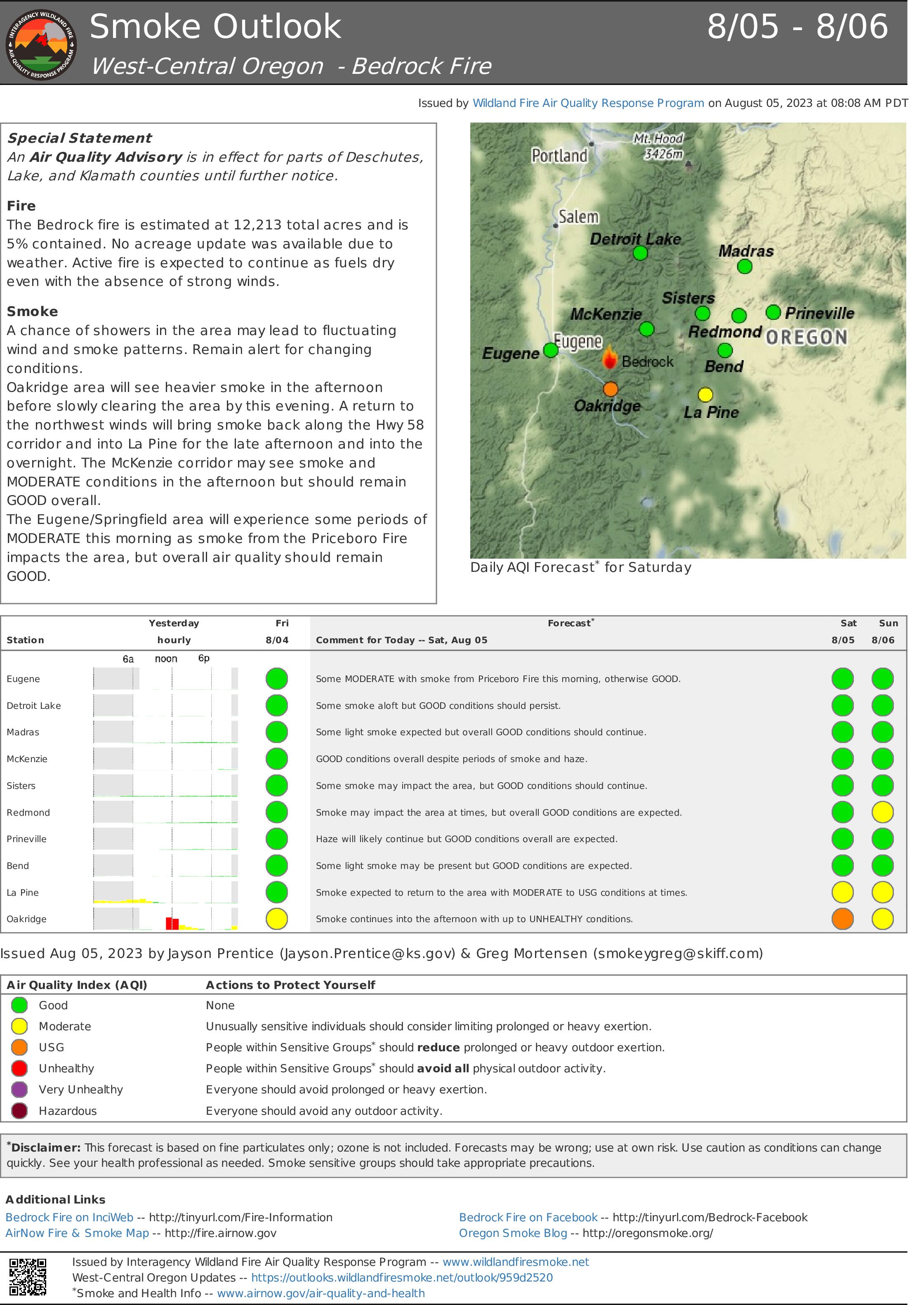
Smoke Outlook for August 5 6 2023
Related Incident: Bedrock Fire
Publication Type: News
The Bedrock fire is estimated at 12,213 total acres and is 5% contained. No acreage update was available. An increase in clouds and relative humidity may lead to decrease in fire behavior.
Brief smoke impacts are possible along the McKenzie this morning but primarily GOOD conditions are expected. Oakridge and La Pine will see periods of smoke today and into tonight with up to UNHEALTHY conditions at times although some periods of GOOD-MODERATE are also expected. Showers/storms in the area today may cause brief gusty winds and could push smoke in any direction - be alert for quickly changing conditions.
Smoke will be possible over the weekend in Eugene/Springfield during the morning, and McKenzie corridor for morning to midday, with brief MODERATE conditions expected. A majority of the smoke though will continue to be pushed to the southeast of the fire impacting Oakridge, La Pine, and into parts of Klamath and Lake Counties.
Dry Lake Fire News Release August 5
Related Incident:
Publication Type: News
Bayfield, CO, August 5, 2023 – Firefighters made progress during yesterday’s blacklining operations on the perimeter of the Dry Lake Fire. The 300-acre lightning-caused fire is burning in the First Notch area of the Columbine Ranger District. It ignited within a network of off-highway vehicle (OHV) trails and National Forest System roads that are being used as containment lines. The blacklining operation was completed around roughly 45% of the containment line, removing fuel along roads and trails to effectively make them wider. Today’s operations will focus on completing the blacklining operations, as well as burning out interior pockets of unburned vegetation using an unmanned aerial system (drone). This evening smoke may settle between Yellowjacket Pass and Chimney Rock on the Highway 160 corridor, and into the Piedra River drainage toward Arboles.
The fire is burning within an area that was treated by a prescribed fire in 2019 and was planned for a second prescribed fire this fall. Fire managers realized the fire could serve an important purpose in reducing future risk of catastrophic wildfire in the area. After a deliberate risk analysis, fire managers chose indirect suppression tactics for the incident so that fire could reduce hazardous fuels within established boundaries. This strategy is expected to reduce the risk to important values such as private residences, lands, and utility infrastructure serving local communities now and in the future by providing firefighters an advantage when conditions are less favorable.
Other benefits of this suppression strategy include reducing hazardous fuels, encouraging the growth of native plants, increasing species diversity in the understory, and restoring ecological balance. These efforts align with the Forest Service's 10-year Wildfire Crisis Strategy, which aims to increase the use of fire on the landscape as well as other treatments to improve forest resiliency for generations to come.
135 fire personnel are assigned to the Dry Lake Fire, which is under command of Incident Commanders Brad Pietruszka and Nate Christiansen (trainee) of the San Juan National Forest Incident Management Team (IMT).
Smoke will be visible to travelers along US Highway 160 between Bayfield and Pagosa Springs, and to some residents in Ignacio and Archuleta County. Please watch for extra fire traffic in the area and along First Notch Road (FR 620) this week and into this weekend.
Wildfire smoke may affect your health. For more information, please go to: https://www.colorado.gov/pacific/cdphe/wood-smoke-and-health
For information on the San Juan National Forest, call (970) 247-4874, visit the forest website, or follow us on social media (Twitter and Facebook).
-USDA-
USDA is an equal opportunity provider, employer, and lender.
August 5 2023 Daily Update
Related Incident:
Publication Type: News
Consalus Fire
Priest Lake Ranger District, Idaho Panhandle National Forests
Incident Commander: Jake Hirst
Fire Information 208-996-0980 | 2023.consalus@firenet.gov
https://tinyurl.com/consalusfire
August 5, 2023
Location: 10 miles west of Coolin, ID, in Pend Oreille County, WA
Start Date: 6/30/2023
Cause: Lightning
Size: 471 acres
Containment: 70%
Total Personnel: 64
Equipment: Dozer, Masticator, Excavator
Fire Modules: 5-person mod + a district mod
Engines: 1
Other: 4 Water Tenders
Updates will be produced as significant activity occurs.
The Consalus fire has stayed within its footprint for nearly two weeks and remains 70% contained, although fire officials are assessing uncontained portions of the perimeter and will likely increase containment in the next couple days. Crews continue to patrol and monitor the fire while working to complete the tasks outlined in the suppression repair plan.
Smoke continues to be visible at times from pockets of unburned fuels that are well with the perimeter of the fire. Heavy equipment will be working on the roads impacted by fire activity for the foreseeable future therefore, the Forest closure order will remain in effect until further notice.
Stage II Fire Restrictions will be going into effect at 12:01 a.m. on Wednesday, 8/9. To view the Idaho Fire Restrictions Plan and a statewide map with current information regarding fire restrictions, please visit https://www.idl.idaho.gov/fire-management/fire-restrictions-finder.
WEATHER AND FIRE BEHAVIOR
Chances of thunderstorm activity is predicted starting today (8/5) through next Wednesday (8/9). Increasing clouds and precipitation is expected this weekend with high temperatures in the low to mid 70’s and dropping to the mid 60’s early next week. Winds are forecasted to be light to moderate except potential gusty winds associated with thunderstorms.
CLOSURES AND SPECIAL MESSAGES
The Idaho Panhandle National Forests issued an emergency closure (Closure Order # 01-04-08-23-003) effective July 18, 2023. This replaced Closure Order #01-04-08-23-002. The emergency closure has been issued for public safety and prohibits all forms of travel on: Forest Service Road (FSR) #1108 from the junction with FSR #333 to the junction with FSR #659; FSR #1094 will remain open for the first 4.5 miles from the junction with FSR #312, but the remainder of FSR #1094 will be closed to the junction with FSR #1108. Additional road closures now include FSR #659 from the junction with FSR #312 to the junction with FSR #659B; FSR #333 from the junction with FSR #2730 to its terminus.
For firefighter and public safety, please avoid the following roads if possible: The remaining portion of FSR #1094 not part of the closure order; FSR #312 from the junction with FSR #333 to the junction with FSR #659; and FSR #333 from Highway 57 to the junction with FSR #1108. Please refer to the incident PIO map for a visual explanation.
West Hallett and West Anderson Fire Update 852023 Morning
Related Incident: West HallettWest Anderson
Publication Type: News
Cheney, WA, - The West Hallett Fire was reported at 1337 on Monday July 31st. It is located approximately 2 miles West of Highway 195 North of the Cheney Spokane Road.
Cheney, WA, - The West Anderson Fire was reported at 1708 on Wednesday August 2nd. It is located approximately ½ mile east of the city of Cheney South of West Anderson Road.
Currently there are approximately 150 line and support personnel assigned to the fires. As we work towards full containment on West Hallett, we will be de-mobilizing crews to right size the number of personnel for the smaller West Anderson Fire.
The West Hallett fire is 90% contained and is sized at 126 acres. Evacuation levels are at level 1 (be ready to go) for residences within the fire perimeter. See attached map for clarification.
The West Anderson Fire is 25% contained and is sized at approximately 48 acres. Evacuation levels are at level 1 (Be ready to go) for areas along West Anderson road south of Cheney Spokane Road. See attached map for clarification.
Washington Department of Natural Resources and Spokane County Fire District 3 have assigned management of both fires to a Northeast Washington Interagency Type 3 Incident Management Team.
On West Hallett, firefighters continue to make progress toward the fire being 100% contained. Isolated hot areas are being searched out and are being extinguished as they are found.
On West Anderson, Firefighters are still working to enhance control lines around the fire. They have established a perimeter of at least 25 feet around the entire fire. Crews put a hose lay around the fire and are utilizing it to provide water for mop-up as vehicle access is very limited.
The Fish lake/Columbia Plateau trail through the fires is closed to the public for safety concerns. We anticipate it re-opening Tuesday.
The incident command post is located at the Cheney middle School in Cheney WA. Fire information contact is Eric Keller at 509-481-7064.
York Fire Daily Update for August 5 2023
Related Incident: 2023 - York Fire
Publication Type: News
Location: San Bernardino County, CA & Clark County, NV
Start Date: Friday July 28, 2023, at 12:09pm
Cause: Under Investigation
Size: 93,078 acres including 9,127 acres in Clark County, NV
Percent Contained: 93%
Vegetation: Timber (litter and understory), tall grass, and brush
Number of Personnel Assigned: 325
As of this morning August 5, the York Fire is at 93,078 acres with 93% containment. 9,127 acres are in Clark County, NV. Today, management of the fire will transition from California Incident Management Team 13 to a local team.
Firefighters successfully continue to extinguish any remaining heat on the fire’s perimeter using Minimal Impact Suppression Techniques (MIST). Crews focused their efforts patrolling for hot spots and monitoring cooled areas.
Land managers and fire personnel continue to collaborate with natural and cultural resource specialists, known as “REsource ADvisors” or “READs,” to implement MIST. READs have many specialties, including wildlife biology, plant ecology, archaeology, and geology. They work closely with fire crews to minimize the impacts of wildfire and of suppression activities.
Demobilization of excess resources has begun. Sufficient resources will remain to complete all objectives. Dry air and falling humidity have filtered back into the region, bringing more challenging conditions for firefighters. Air support is available if needed.
The joint effort to suppress the York Fire is a testament to the abilities of wildfire emergency resources. The involvement of the National Park Service, Bureau of Land Management, USDA Forest Service, California Department of Forestry and Fire Protection (CAL FIRE), San Bernardino County Fire Protection District, and Clark County Fire highlights the scale of the fire and the need for extensive resources to tackle it effectively.
York Fire staff are working closely with Clark County Communications to provide timely and accurate information to the public. If you have any questions regarding the residential areas of Nipton and Searchlight, please reference Clark County Public Communications or their Twitter at Clark County Nevada
WEATHER: Sunny skies with hot and dry conditions persist across the region
EVACUATIONS: No current evacuations.
PARK & ROAD CLOSURES: Ivanpah Rd. between Morning Star Mine Rd and Cedar Canyon Rd., as well as all of Hart Mine Rd. are closed due to hazardous wildfire conditions and fire suppression operations. Mojave National Preserve is also under Extreme Fire Restrictions, please visit their website for more information on restrictions and closures: Alerts & Conditions - Mojave National Preserve . Please visit Road Conditions - Mojave National Preserve to view a detailed map of current park closures.
Stage 2 Fire Restrictions in Effect
Related Incident:
Publication Type: Announcement
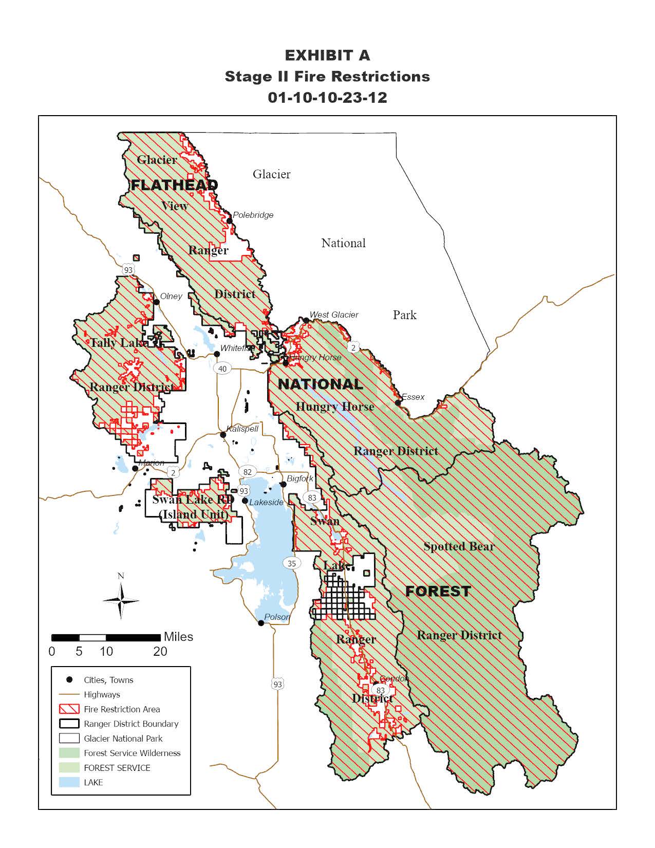
The following is prohibited on the National Forest System (NFS) lands in the Flathead National Forest described below and shown on the attached map incorporated into this Order as Exhibit A (the “Described Area”):
1. Igniting, building, maintaining, attending, or using a fire. (Including fires fueled by charcoal or briquettes).
a. Exception: A device solely fueled by liquid or gas that can be turned on and off used in an area barren or cleared of all flammable materials within three feet of the device; or
b. Exception: A fully enclosed metal stove with a chimney at least five feet in length and a mesh screen spark arrestor with a screen opening of a ¼ inch or less used in an area that is barren or cleared of all flammable materials within 10 feet of the device.
2. Smoking, except in an enclosed vehicle or building, a developed recreation site, or while stopped in an area at least three feet in diameter that is barren or cleared of all flammable materials.
3. Operating or using any internal or external combustion engine without a spark arresting device properly installed, maintained and in effective working order meeting either U.S. Department of Agriculture, Forest Service Standard 5100-1a; or appropriate Society of Automotive Engineers (SAE) recommended practice J335(b) and J350(a). For chainsaw use a chemical pressurized fire extinguisher (with a minimum 8 oz. capacity and rating of 2A) must be kept with the operator, and a round point shovel with an overall length of at least 35 inches readily available for use.
a. Operating generators with an approved spark arresting device is permitted only within an enclosed vehicle or building or in an area that is barren or cleared of all overhead and surrounding flammable materials within three feet of the generator.
4. Blasting, welding, or operating acetylene or other torch with open flame, except if in a cleared area of at least 10 feet in diameter and a chemical pressurized fire extinguisher (with a minimum 8 oz. capacity and rating of Class 2A) is kept with the operator.
5. Using an explosive. This includes but is not limited to fuses, blasting caps, fireworks, rockets, exploding targets, tracers, and incendiary ammunition.
6. Possessing or using a motor vehicle off NFS roads, except when parking in an area devoid of vegetation within 10 feet of the motor vehicle.
Stage 2 Fire Restrictions in Effect on Flathead National Forest
Related Incident:
Publication Type: Announcement
The following is prohibited on the National Forest System (NFS) lands in the Flathead National Forest described below and shown on the attached map incorporated into this Order as Exhibit A (the “Described Area”):
1. Igniting, building, maintaining, attending, or using a fire. (Including fires fueled by charcoal or briquettes).
a. Exception: A device solely fueled by liquid or gas that can be turned on and off used in an area barren or cleared of all flammable materials within three feet of the device; or
b. Exception: A fully enclosed metal stove with a chimney at least five feet in length and a mesh screen spark arrestor with a screen opening of a ¼ inch or less used in an area that is barren or cleared of all flammable materials within 10 feet of the device.
2. Smoking, except in an enclosed vehicle or building, a developed recreation site, or while stopped in an area at least three feet in diameter that is barren or cleared of all flammable materials.
3. Operating or using any internal or external combustion engine without a spark arresting device properly installed, maintained and in effective working order meeting either U.S. Department of Agriculture, Forest Service Standard 5100-1a; or appropriate Society of Automotive Engineers (SAE) recommended practice J335(b) and J350(a). For chainsaw use a chemical pressurized fire extinguisher (with a minimum 8 oz. capacity and rating of 2A) must be kept with the operator, and a round point shovel with an overall length of at least 35 inches readily available for use.
a. Operating generators with an approved spark arresting device is permitted only within an enclosed vehicle or building or in an area that is barren or cleared of all overhead and surrounding flammable materials within three feet of the generator.
4. Blasting, welding, or operating acetylene or other torch with open flame, except if in a cleared area of at least 10 feet in diameter and a chemical pressurized fire extinguisher (with a minimum 8 oz. capacity and rating of Class 2A) is kept with the operator.
5. Using an explosive. This includes but is not limited to fuses, blasting caps, fireworks, rockets, exploding targets, tracers, and incendiary ammunition.
6. Possessing or using a motor vehicle off NFS roads, except when parking in an area devoid of vegetation within 10 feet of the motor vehicle.