
Smoke Outlook August 6 2023
Related Incident: Lowline Fire
Publication Type: News
Special Statement
CRITICAL FIRE WEATHER WATCH : RED FLAG WIND WARNINGS TODAY. High winds in the afternoon with gusts into the evening.
Fire
The Lowline wildfire is currently at 1,816 acres and 55% containment.
Smoke
With cooler temperatures this morning we will see MODERATE air quality Sunday morning in Gunnison. With smoke clearing out mid-day when winds increase out of the west. Castleton area along County Road #730 will see GOOD air quality today in the area, with some possible MODERATE smoke in the afternoon with increasing west winds. Crested Butte will see GOOD air quality in the area today. Aspen will continue to see GOOD air quality throughout the day.
Air Quality Alert
Air Quality Health Advisory for Wildfire Smoke for central Gunnison County.
Lost Horse Creek Fire Update Saturday August 5 2023
Related Incident: Lost Horse Creek Fire
Publication Type: News
Incident Commander: Peter Butteri
Start Date: July 28, 2023
Location: 22 miles N of Fairbanks, AK
Cause: Undetermined
Fire Size: 1,946 acres
Containment: 0%
Total Personnel: 161
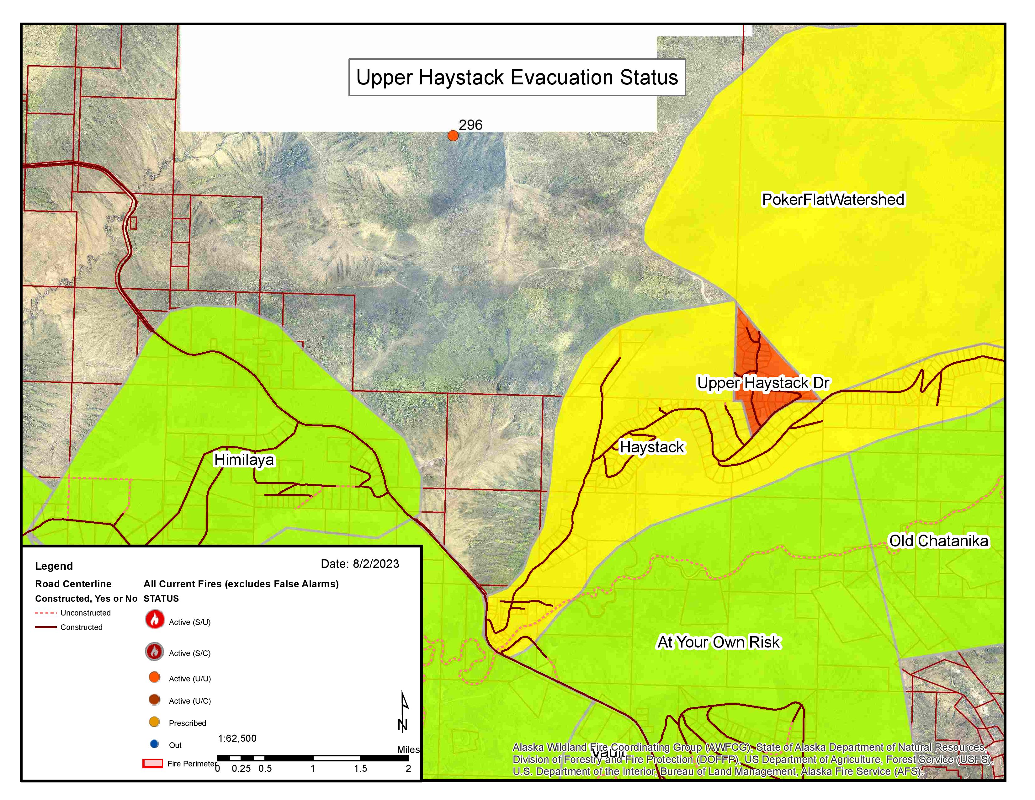
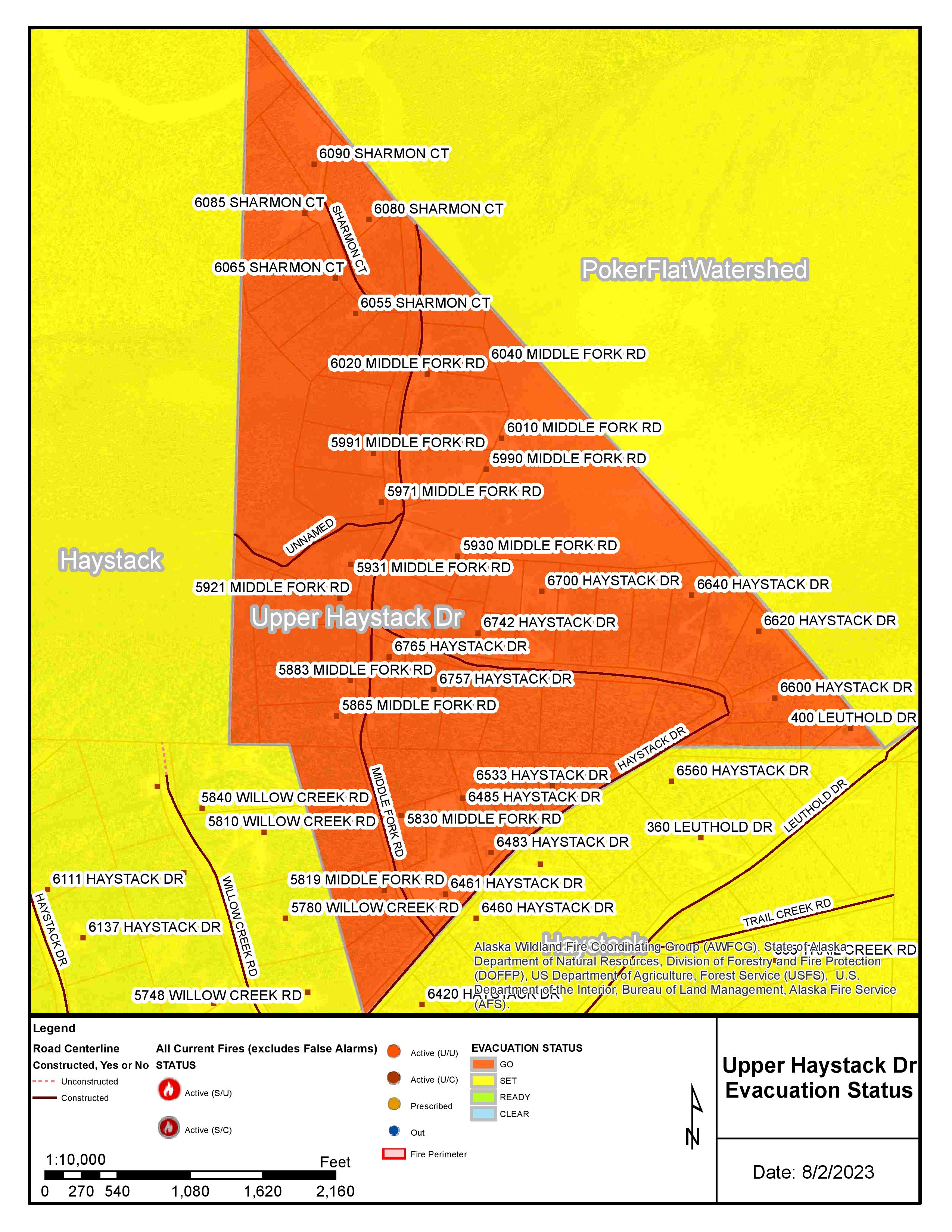
(Fairbanks, AK) – With favorable winds, crews on the Lost Horse Creek Fire (#296) made progress on a bulldozed containment line reinforced with fire retardant. This line is being extended to the east/southeast into the Caribou Creek drainage. Pumps, water tanks, and hose lays arrived on site as crews conduct structure assessment and protection in the Haystack Subdivision. Air tankers, Super Scoopers, and Fire Bosses support ground operations including the Big River Alaskan contract hand crew, a strike team of four engines, three dozers, and a water tender as they identify line placement to minimize fire spread.
Fire activity is expected to increase over the weekend as warm, dry weather continues. Public information boards can be found at the Haystack Subdivision entrance and Hilltop Truck Stop.
The Alaska Team is managing six additional fires: the Sargent Creek Fire (#255), Our Creek Fire (#271), Murphy Creek Fire (#320), Treasure Creek (#265), Olnes Pond (#250), and Hayes Creek (#266). These fires are currently in stages of mop up and monitoring and are expected to be contained by the end of next week.
EVACUATIONS: The “GO” level evacuation notice issued by the Fairbanks North Star Borough remains in effect for Upper Haystack Drive, including Sharmon Court and All of Middle Fork Road in the Haystack Subdivision.
AIR QUALITY ADVISORY: An air quality advisory is in effect for central and eastern Alaska until Sunday, August 6, 2023 at 10:00 am. Major smoke impacts within the Tanana Flats/Valley. Low level winds will continue to carry the smoke east until a wind shift Saturday. Winds on Saturday will be from the south and push more of the smoke into the Fairbanks North Star Borough. Air Quality will vary between Good and Very Unhealthy depending on the location relative to the fires and wind flow in/around the fires. For more information, see the Fairbanks North Star Borough air quality map.
TEMPORARY FLIGHT RESTRICTIONS (TFR) are in effect until September 1, 2023. For details, see: 3/6714 NOTAM Details (faa.gov)
Public Information: (907) 921- 2555
Media Inquiries: (907) 921- 2554
Email: 2023.LostHorseCreek@firenet.gov
www.facebook.com/AK.Forestry
Lost Horse Creek Fire Update Friday August 4 2023
Related Incident: Lost Horse Creek Fire
Publication Type: News
The Lost Horse Creek Fire spread an estimated 500 acres to the east/southeast into the Caribou Creek drainage behind the Haystack Subdivision yesterday. The east flank of the fire was burning towards the 2021 Haystack Fire scar. The fire is estimated to be 1,900 acres. With warm, dry weather expected through the weekend, fire activity is likely to continue.
Air tankers, Super Scoopers and Fire Bosses continued working to reduce spread as ground forces moved into place. Firefighters include the Big River Alaskan contract hand crew, a strike team of four engines, three dozers, and a water tender.
Dozers began constructing containment line from the saddle below the prominent holding ridge to Caribou Creek. Fire managers are using existing fuel breaks and two-track roads to attempt to contain the fire. Pumps, water tanks, and hose lays needed to implement the Haystack subdivision structure protection plan began arriving yesterday. Public Information boards can be found at the Haystack subdivision entrance and Hilltop Truck Stop.
Today at 8:00 am Alaska’s Type 2 Incident Management Team took command of the Lost Horse Creek Fire under the leadership of Incident Commander Peter Butteri.
EVACUATIONS: The “GO” level evacuation notice issued by the Fairbanks North Star Borough remains in effect for Upper Haystack Drive, including Sharmon Court and All of Middle Fork Road in the Haystack Subdivision.
Fairbanks North Star Borough Evacuation Notice
Related Incident: Lost Horse Creek Fire
Publication Type: Announcement
PUBLIC SERVICE ANNOUNCEMENT
Fairbanks North Star Borough
August 2, 2023, 10:00 pm
**ACTION IS REQUIRED!**
FNSB EMERGENCY OPERATIONS HAS ISSUED A LEVEL 3 EVACUATION NOTICE for the UPPER HAYSTACK DRIVE, INCLUDING SHARMON COURT and ALL OF MIDDLE FORK ROAD in the HAYSTACK subdivision, north of Fairbanks.
This means GO, evacuate, LEAVE NOW!
The wildfire danger in the area has increased and you must leave the area NOW! Do not delay leaving the area.
Residents are requested to assemble at the HAYSTACK LAUNDRY & SHOWER, located at 5100 Haystack Drive, for further instructions.
If you choose to ignore this notice, you are advised that emergency services may NOT be able to assist you. This is the last alert that you will receive. Re-entry to the evacuated area may be restricted until the area is safe.
The best map to identify your FNSB neighborhood and evacuation status is FNSB's Find My Neighborhood/Evac Neighborhood Status Map: https://bit.ly/3BCKi62
Read Fire News from multiple agencies: https://akfireinfo.com/
Alaska Wildland Fire Information Map Series: https://arcgis.is/OSaTe
This information will be updated as it becomes available.
Aug 5 2023 New Fire Start on the Carson National Forest
Related Incident: American Mesa Fire
Publication Type: News
Carson National Forest firefighters responded to a lightning-caused fire on the Jicarilla Ranger District this afternoon. The approximately 400-acre American Mesa Fire is located off Forest Road 310E, about 16 miles southwest of Dulce, N.M.
Firefighters, with the assistance of air resources, took suppression actions to limit the fire’s growth and protect nearby natural gas infrastructure. Incident command staff are ordering more resources and coordinating with local agencies.
Smoke was first called in around 1:30 p.m. and the fire rapidly grew from there. It burned with high intensity in predominantly piñon-juniper habitat and is expected to grow over the coming days. Weather continues to be hot and dry, with elevated to critical fire weather concerns on Monday.
The public can monitor smoke on the Smoke and Fire Map, which currently shows smoke moving east. Tips for protecting health are available on New Mexico Fire Information’s Smoke Management webpage.
As the fire develops, public information officers will continue to post fire updates on InciWeb, New Mexico Fire Information and Carson National Forest’s social media channels (Facebook, Twitter).
Elkhorn Fire River Rafting Management August 5 2023 800pm
Related Incident: Elkhorn Fire
Publication Type: Announcement
McCall, Idaho – Beginning August 6, 2023 boaters are required to stop at Hancock Campsite on river left at river mile 26.1 to receive further instruction from a Forest Service representative regarding passing through and camping in the area of the Elkhorn fire.
Camping and stopping through the area of fire activity is allowed beginning August 6 with some exceptions that will be explained at Hancock Camp.
Fire activity has significantly altered the landscape on both sides of the river in the area of the Elkhorn fire. Be on the lookout for falling rocks, logs, and other debris. Please exercise caution when floating through the fire area. Do not impede any firefighting operations - move out of the way of jetboats carrying firefighting personnel when possible. Follow instructions from Forest Service personnel. As your group passes through the fire area, stay together as a group with all boats in the party staying within close proximity to each other.
After checking in with Forest Service personnel at Hancock Camp (river left, river mile 26.1), and if you choose to camp or stop in the area of the fire, watch out for:
- Burned snags, trees, and limbs falling in or near the burn perimeter, especially in windy conditions.
- Rolling rocks or logs, especially near trails and river corridors
- Debris in rivers, streams, and trail
- Stump holes in and near the fire perimeter where roots and stumps have burned out underground.
- Increased risk of flash flooding
- Campsite and tent placement near standing burned trees.
- Consider the prevailing wind when establishing camps in burned areas.
For additional Elkhorn Fire Information:
- Elkhorn Fire Information - InciWeb the Incident Information System (nwcg.gov)
- Fire information at the Incident Command Post can be reached at 208-718-2234, and follow the Payette National Forest on Twitter at @PayetteForest, and on Facebook at U.S. Forest Service – Payette National Forest.
- For permit rollover information and other river information call the Salmon – Challis National Forest River Clerk at 208-756-5587 or 208-481-2625.
What you need to know to be prepared during fire season:
- Check the fire situation before your launch and heed safety warnings.
- Know that you are traveling at your own risk. There is will not be a Forest Service representative readily available to assist you if you get into a dangerous situation.
- Be prepared to evacuate if fire conditions change.
- Stay clear of active fire suppression activities and crews.
- Expect smokey conditions that may impact aircraft and satellite service.
- Access points such as airstrips and roads may be affected.
- Heavy rains on burned areas may create new river hazards and rapids.
- Expect conditions to change in this dynamic environment. Wildfires play an important role in shaping the landscape along the river corridor. They may also alter your itinerary while on the river.
- If encountering active fire, assess whether to eddy out or float through on the opposite side of the river; conditions are continually changing.
- Watch for roll-out; trees that have or are burning may roll into the river or trails, and heat can displace rocks.
- Helicopters may be working in the area and dipping from various water sources.
- When driving to/from launch/take-out, be aware of heavy vehicles and increased traffic due to fire support vehicles and closures.
- Smoke will impede visibility - travel with extra caution.
Fire Effects – Post Fire Information for Boaters:
- Fires have burned a significant number of acres within the wilderness, including several miles of the Salmon River corridor.
- Wildfire is a natural ecological agent and as such is allowed to play its natural role within the Frank Church--River of No Return Wilderness.
- During your trip, you will encounter areas that burned as a result of these fires, which can create varied effects on the landscape.
- Caution should be observed while traveling in or near a burned area. Also be aware that new fires can occur throughout the float season.
Check the Forest website for fire information, restrictions, and closures. Watch out for:
- Burned snags, trees, and limbs falling in or near the burn perimeter, especially in windy conditions.
- Rolling rocks or logs, especially near trails and river corridors.
- Debris in rivers, streams, and trail.
- Stump holes in and near the fire perimeter where roots and stumps have burned out underground.
- Increased risk of flash flooding.
- Campsite and tent placement near standing burned trees.
- Consider the prevailing wind when establishing camps in burned areas.
The Incident Management Team has a public wildfire information hotline for fire information – 208-718-2234. Visit InciWeb for information on large wildfires at https://inciweb.nwcg.gov , and follow the Payette National Forest on Twitter at @PayetteForest, and on Facebook at U.S. Forest Service – Payette National Forest.
###
West Hallett and West Anderson Fire Update 852023 Evening
Related Incident: West HallettWest Anderson
Publication Type: News
Cheney, WA, - The West Hallett Fire was reported at 1337 on Monday July 31st. It is located approximately 2 miles West of Highway 195 North of the Cheney Spokane Road.
Cheney, WA, - The West Anderson Fire was reported at 1708 on Wednesday August 2nd. It is located approximately ½ mile east of the city of Cheney South of West Anderson Road.
Currently there are approximately 150 line and support personnel assigned to the fires. As we work towards full containment on West Hallett, we will be de-mobilizing crews to right size the number of personnel for the smaller West Anderson Fire.
The West Hallett fire is 95% contained and is sized at 126 acres. Evacuation levels are at level 1 (be ready to go) for residences within the fire perimeter. See attached map for clarification.
The West Anderson Fire is 35% contained and is sized at approximately 48 acres. Evacuation levels are at level 1 (Be ready to go) for areas along West Anderson road south of Cheney Spokane Road. See attached map for clarification.
Washington Department of Natural Resources and Spokane County Fire District 3 have assigned management of both fires to a Northeast Washington Interagency Type 3 Incident Management Team.
On West Hallett, firefighters continue to make progress toward the fire being 100% contained. Isolated hot areas are being searched out and are being extinguished as they are found. There will be minimal personnel on this fire on 8/6/2023.
On West Anderson, Firefighters have established a perimeter around the entire fire and are utilizing a hose lay around the fire and are utilizing it to mop-up as vehicle access is very limited. Crews will continue to work inward toward complete extinguishment.
The Fish lake/Columbia Plateau trail through the fires is closed to the public for safety concerns. We anticipate it re-opening Tuesday.
The incident command post is located at the Cheney middle School in Cheney WA. Fire information contact is Eric Keller at 509-481-7064.
Turkey Fire update August 5 2023
Related Incident:
Publication Type: News
MIMBRES, NM, Aug. 5, 2023 – Increased activity on the Turkey Fire is producing smoke that is very visible from Gila, Cliff and Silver City. The wildfire was flown and mapped at 1,300 acres Saturday.
The wildfire was discovered on July 22 high on a ridge of the Pinos Altos Range on the edge of the Gila Wilderness. It is currently spreading in Shelly and Spring Canyon through ponderosa pine, pinyon-juniper, and brush. The fire is expected to make slope runs when fuels align with topography. To the west, the fire will run into very rugged, rocky, and steep terrain with less fuel continuity. Due to the rugged, inaccessible terrain, Forest Lookouts and aircraft will continue to monitor the fire.
A high-pressure system is in place over the region bringing warmer and drier conditions. The forecast calls for sunny skies, temperatures in the 90s with wind and humidity in the teens. There is a chance of thunderstorms on Monday.
Flathead National Forest Fire Update Press Release 832023
Related Incident:
Publication Type: News
Please see the attached press release regarding a fire update from the Flathead National Forest on 8/3/2023
Hungry Horse Ranger District Area Closure
Related Incident:
Publication Type: Closures
Order Number: # 01-10-06-23-16
U.S. Department of Agriculture, U.S. Forest Service
Flathead National Forest
Hungry Horse Ranger District
Area Closure
PROHIBITIONS
Pursuant to 16 U.S.C. § 551 and 36 C.F.R. § 261.50 (a) the following is prohibited on the National Forest System (NFS) lands, roads, and trails on the Hungry Horse Ranger District, Flathead National Forest described below and shown on the attached map incorporated into this Order as Exhibit A.
1. It is prohibited go into the areas, including to be upon any road or trail in the area, closed for the protection of: Public health or safety. 36 C.F.R. § 261.53(e).
EXEMPTIONS
Pursuant to 36 C.F.R. § 261.50(e), the following persons are exempt from this Order:
1. Persons with Forest Service Permit No. FS-7700-48 (Permit for Use of Roads, Trails, or Areas Restricted by Regulation or Order), specifically exempting them from this Order or a written determination by a Forest Service authorized officer that a permit is not required under 36 C.F.R. § 251.50(e)(1) or (2).
2. Any Federal, State, or Local Officer, or member of an organized rescue or firefighting resource in the performance of an official duty.
DESCRIBED AREAS
East Side Hungry Horse Area The northern boundary of the East Side closure area starts at the northeastern most corner of the Coram Experimental Forest boundary in section 26 T28N R19W and follows this boundary east to Desert Mountain and then due east to the Great Bear Wilderness boundary.
The eastern boundary then runs southeast along the Great Bear Wilderness boundary to Prospector Mountain and the Great Bear Wilderness boundary in section 9 T27N R16W.
The southern boundary runs from Prospector Mountain west along the Hungry Horse/Spotted Bear District boundary where it crosses to NFS Road 38. Continuing, the southern boundary is the waterline of Hungry Horse Reservoir north to the SW corner of section 23 T30N R19W, which is about 1 mile west of Abbot Bay Boat Launch.
The western boundary runs north along the west side of section 23 T30N R19W to the