
Big Knife Fire Update August 6 2023
Related Incident: Big Knife
Publication Type: News
Big Knife, Niarada, & Mill Pocket Fires
Daily Update August 6, 2023
Confederated Salish and Kootenai Tribes
Fire Information: 406-426-9595 | 2023.BigKnife@firenet.gov
https://tinyurl.com/BigKnifeFire | https://tinyurl.com/NiaradaMillPocketFires
Location: Big Knife - 5 miles east of Arlee, MT | Niarada - 12 miles west of Elmo, MT | Mill Pocket: 3 miles West of Hwy. 28
Start Date: Big Knife - 7/24/2023 | Niarada - 7/30/2023 | Mill Pocket – 7/30/2023 Cause: Lightning
Big Knife- 4,864 acres, 0% contained | Niarada – 17,514 acres, 0% contained | Mill Pocket – 2,135 acres, 0% contained
Total Personnel: 505 | Engines: 27 | Aircraft: 1 + others available as needed | Hand Crews: 8
Big Knife Fire
Fire Saturday's moisture over the Big Knife Fire area helped moderate fire behavior and growth, and the fire primarily burned in the heavy fuels- backing, flanking, and creeping. The fire is burning in extremely steep terrain, fueled by heavy timber and significant dead and down fuels. Heavy equipment operators completed a mastication line along the fire's southwestern edge to reduce fuels, and firefighters continued holding and improving a strategic firing operation they completed late Friday to keep the fire north of Agency Creek. Aircraft are aiding crews as conditions allow, although limited visibility has hindered some air operations.
Niarada Fire & Mill Pocket Fire
The Niarada Fire also received some very light precipitation Saturday, sufficient to help moisten fine (grassy) fuels but insufficient to be considered a “wetting rain.” Heavy fuels near the fire’s southeastern perimeter continued to torch Saturday. Fixed-wing scooper planes supported ground crews to help cool heavy fuels and catch the fire as it came into the grass west of White Earth Creek. Crews continued to assess and prepare structure protection measures northwest of Elmo if erratic winds push the fire in that direction again. Firefighters also continued holding and mopping up line north of Highway 28, along Cromwell Creek Road. This weekend’s moisture will allow crews to capitalize on reduced fire behavior. Firefighters will be working on a direct line along the fire’s southeastern fire edge where it is safe. Firefighters working the Mill Pocket Fire continue to hold and improve the fireline around the fire’s northwestern perimeter, which is hung up in scree fields.
WEATHER AND FIRE BEHAVIOR
Much-needed precipitation began occurring over all fire areas Saturday; however, amounts vary significantly between Arlee and Elmo. Humidity and fuel moistures around the Niarada and Mill Pocket fires continue to be drier than those around the Big Knife Fire. Meteorologists forecast increased potential for thunderstorms and precipitation Sunday, with a slight drying trend into next week. Although incoming moisture may help temporarily moderate potential fire behavior (lessening the chance of long runs and torching in the short term), thunderstorms also bring concerns about erratic, outflow winds. Weather conditions and trends show continued potential for active fire behavior in the coming week.
CLOSURES AND SPECIAL MESSAGES
The Lake County Sheriff has placed several areas near the base of the mountains west of the Big Knife Fire in PREEVACUATION status. See the map for those locations in yellow (Jocko, Canal, Francis). In the Tribal Primitive Area, Belmore Slough and Burnt Cabin Roads are closed.
Near the Niarada Fire, the Lake County Sheriff placed several residences in the following areas in-EVACUATION status Friday afternoon: Alexander Road, Early Dawn Road, Spring Lane Road, Walking Horse Lane, Windward Heights Road, Wildhorse View, Buffalo Bridge Road, Saddle Drive, Island Butte Lane, Bridle Path, Ten Deuce Way, Cliffview Drive, and Ricketts Road. The remainder of the town of Elmo is in READY status. The Flathead County Sheriff’s Office has issued a PRE-EVACUATION WARNING for Hubbart Dam Rd/NF-544 from the intersection of Crossover Rd South to Hwy 28.
A MANDATORY EVACUATION remains in place from the top of the Pass on Brown’s Meadow Road South to Hwy 28, Nirada. This mandatory evacuation also includes Kofford Ridge Rd.
Fire managers are working with the Lake and Flathead County sheriff’s offices to constantly address the current evacuation orders. The decision to lift or expand any evacuation areas or status is made based upon the current and predicted fire conditions, done in concert with all decision-making parties, and will be announced through official channels.
Use extreme caution when driving on Highway 28. Authorities reduced speed limits to 45 mph due to poor visibility, and firefighters and equipment are still working in the area.
Dry Lake Fire News Release August 6
Related Incident:
Publication Type: News
Bayfield, CO, August 6, 2023. The Dry Lake Fire is now 11 percent contained and firefighters have completed “blacklining” the control lines around the 1372-acre fire. 135 fire personnel are assigned to the fire, located on San Juan National Forest land northeast of Bayfield. In conjunction with blacklining, interior pockets of vegetation were burned with an Unmanned Aerial System (UAS), or drone. Firefighters are now patrolling the perimeter and no further growth is expected. Continued burning and smoldering of interior vegetation will continue, though fire activity and smoke production will decrease. This evening, smoke may settle between Bayfield and Chimney Rock in the Highway 160 corridor, and into the Piedra River drainage toward Arboles.
The lightning caused fire started August 1 and has given fire managers the opportunity to directly address the long-term risk of catastrophic wildfire in this fire footprint. The San Juan National Forest Type 3 Incident Management Team (IMT) managing firefighting efforts have been suppressing the fire utilizing the indirect tactics as described above. Benefits of this strategy include reducing hazardous fuels, encouraging native plant growth, increasing species diversity in the understory, and restoring ecological balance. The Dry Lake Fire is burning at the northeast edge of a Potential (wildfire) Operational Delineation (POD). PODs are developed by local wildland fire management specialists to pre-identify a network of best-available control features. The work previously done near the POD boundary northeast of the Dry Lake Fire is serving its purpose as a control feature.
The comprehensive risk analysis completed by fire managers and selected fire management strategy aligns directly with the Forest Service’s 10-year Wildfire Crisis Strategy. This strategy aims to increase the use of fire on the landscape as well as other treatments to improve forest resiliency for generations to come. Additionally, these fire management actions are expected to reduce the risk to important local values at risk such as private residences, lands, and utility infrastructure. In fact, firefighters carefully burned vegetation under and around a 1/2 mile stretch of the Tri-State power line, which serves the community of Pagosa Springs.
Smoke will continue to be visible to travelers along US Highway 160 between Bayfield and Pagosa Springs, and to some residents in Ignacio and Archuleta County. Please watch for extra fire vehicle traffic in the area and along First Notch Road (FR 620) through the weekend and early into the coming week.
Wildfire smoke may affect your health. For more information, please go to: https://www.colorado.gov/pacific/cdphe/wood-smoke-and-health
For information on the San Juan National Forest, call (970) 247-4874, visit the forest website, or follow us on social media (Twitter and Facebook).
Sourdough Fire Daily Update August 6 2023
Related Incident:
Publication Type: News
2023.Sourdough@firenet.gov
360-370-4169
https://inciweb.nwcg.gov/incident-information/warlp-sourdough-fire
Fire Size: 1,397 Containment: 0% Personnel: 331 Helicopters: 3
This is the final daily update from the Southern Area Incident Management Gray Team, led by Incident Commander Mitch Ketron. The Northwest Team 10 Incident Management Team takes command of the Sourdough Fire Monday August 7, at 6:00 AM.
This is a no-drone zone. Unauthorized drone flights (UAS) pose serious risks to firefighter and public safety and the effectiveness of wildfire suppression operations. Aerial firefighting is suspended when unauthorized UAS are in the area, allowing wildfire to grow larger.
Yesterday’s Activities: Assessments from Ross Dam eastwards to Big Beaver Creek were conducted, as well as assessments westward along State Road 20 towards Newhalem. Helicopters were used extensively, dropping water to slow fire spread after the morning inversion lifted. Fire personnel were actively engaged in structure protection, triage, and preparation based on fire location and behavior, which included setting up hose lays, sprinkler systems, and preparing structures in the town of Diablo and the Environmental Learning Center. Structure protection efforts around the Diablo community, were implemented successfully. Structure preparation, including wrapping, is complete at the historic Sourdough Lookout.
Today: Total Sourdough Fire acreage was adjusted down due to more accurate mapping with an infrared helicopter flight. Fire personnel will continue to scout and identify possible fire containment lines. Terrain is extremely steep, rugged, and inaccessible. Helicopter water drops will continue to slow fire spread. Although moisture is predicted through the area over the weekend the amount is not significant enough to slow the fire's progression.
Weather: Partly sunny (50-60 percent). Areas of smoke in the morning. Chance of showers throughout the day with a high near 82. West winds 5-10 mph increasing from the west-southwest in the afternoon to 12-15 mph. Gusty and erratic winds expected near thunderstorms in the afternoon. Humidity 55%. Take caution when recreating outdoors when smoke is present. Learn more at https://wasmoke.blogspot.com
Area/Road Closures & Evacuations EVACUATIONS - Evacuations are in effect for North Cascades Environmental Learning Center and the community of Diablo. There is no access across Diablo Dam until further notice. State Road 20 is closed between Mile Markers 120-156, Newhalem to Rainy Pass. Trail, area, and camp closures are in effect due to fire activity. Closure information can be found at https://www.nps.gov/noca/planyourvisit/fire-closures.htm.
Tin Soldier Complex Daily Update August 6th 2023
Related Incident:
Publication Type: News
The Tin Soldier Complex was originally made up of 4 fires burning in timber litter with heavy dead and down fuels. The Tin Soldier Complex is located on the Spotted Bear Ranger District of the Flathead National Forests, approximately 17 miles east of Swan Lake. The fires associated with the Tin Soldier Complex started by lightning on Saturday, July 30th. Past fire activity has included torching, spotting, and active consumption of heavy fuels.
Current Acres burned as of the morning of August 6th.
- Bruce Fire – 977 acres at 0% containment
- Kah Mtn Fire – 304 acres at 0% containment
- Sullivan Fire – 1,087 acres at 0% containment
- Con Kelly Fire – 0.25 acres – Out.
The Tin Soldier Complex is estimated at 2,368 a cres in size and remains 0% contained. Fire activity Saturday was low between the 3 fires. Data was collected yesterday afternoon with an unmanned aircraft system (UAS). The data is currently being processed and updated acreage on the fire perimeters will be updated later today.
The Bruce, Kah and Sullivan fires are being managed with point source protection to protect values at risk. Values at risk include Stony Communications Site, hydro-electric plant, Heinrude residential community, commercial guest ranches and the Spotted Bear Ranger Station compound. Fire personnel have conducted initial assessments and preparations for structure protection in the above identified areas.
PAST AND PLANNED ACTIONS
Fuel breaks have been established around the Wilderness Lodge and the hydro-electric facility. Hose line and sprinklers have been set up around the Wilderness Lodge. Exposed wood on the hydro-electric facility was wrapped and sprinklers were installed along Addition Bridge. Fire personnel are continuing structure protection efforts for the Spotted Bear Ranch, Diamond R Ranch and the Spotted Bear Ranger Station compound. A safety zone has been established on the Spotted Bear Ranger Station compound. Crews will continue installing hose line and sprinkler systems around the Spotted Bear Ranch, Diamond R Ranch and the Spotted Bear Ranger Station compound. Fire personnel are developing a structure plan for the Heinrude residential community. Those efforts will continue today and into tomorrow.
EVACUATIONS, CLOSURES AND RESTRICTIONS
Evacuation: An evacuation has been issued by the Flathead County Sheriff for Heinrude community.
Restrictions/Closures:
- Stage 2 fire restrictions are in effect as of August 5th.
- A road restriction is in effect for the East and West Side South Fork Roads.
- An area closure is in effect for the front country of the Spotted Bear district as well the Gorge Creek drainage within the Bob Marshall Wilderness area, including Feather, Inspiration, Gorge, Canyon Trickle, and Stadium Creeks.
- A Temporary Flight Restriction is in place for air space over the Tin Soldier Complex to provide a safe environment for firefighting aircraft operating in the area. This includes the Spotted Bear and Meadow Creek Airstrips! Remember that temporary flight restrictions also apply to UAS or drones. If you fly, we can’t!
WEATHER
Cloud cover will keep temperatures cooler today with max temperatures reaching between 70 -75F with increased relative humidities. Chance of rain and thunderstorms throughout the day.
Ridge Fire Daily Update August 6
Related Incident:
Publication Type: News
NORTHERN ROCKIES TEAM 9 INCIDENT COMMANDER: SHANE MARTIN
Ridge Fire
Flathead National Forest, Hungry Horse Ranger District
Fire Information 406-998-6074 2023.ridge@firenet.gov
inciweb.nwcg.gov/incident-information/mtfnf-ridge-fire
August 6, 2023
Location: 6 miles southeast of Hungry Horse, MT
Start Date: 7/30/23 Cause: Lightning Size: 2,584 acres Containment: 0%.
Total Personnel: 115 Dozers: 2 Hand Crews: 4 Water Tenders: 2
KEY MESSAGE
To provide for public and firefighter safety, FS Road 38 (East Side Road) is closed to all public traffic east of the junction of FS Road 497 (Desert Mountain Road) and FS Road 38. FS Road #895 (West Side South Fork Road) is closed to all public traffic starting at mile 15, near the Lid Creek Campground. Pre-evacuation notice in effect for private property along SF Abbot Creek on the west side of the fire.
CURRENT SITUATION
Fire behavior was low to moderate yesterday. Current acreage is at 2,584 acres, an increase of 350 acres. Indirect (away from the fire) suppression efforts are prioritized on the west sides of the fire to protect critical infrastructure and private property. This is a full suppression fire and firefighter and public safety is the top priority.
Yesterday, helicopters provided water bucket drops on the west side of the fire. Hand crews continued work on a fuel break by removing brush and timber to decrease potential fire intensity. Heavy equipment continued work on a fuel break north of the junction of Desert Mountain Road and the East Side Road. Structure protection assessments were being conducted for private property.
Today, hand crews continue implementing a fuel break along FS Road 38 near Emery Bay Campground to decrease potential fire intensity. Heavy equipment crews will scout and implement a fuel break on the west side of the fire to protect private property and the communities of Coram and Martin City. Crews will also implement structure protection measures on Desert Mountain communication sites by wrapping combustible materials. Structure protection assessments will continue for private property in Martin City.
WEATHER AND FIRE BEHAVIOR
Potential for easterly winds and chances of precipitation over the fire area have decreased through the weekend and into next week. Fire behavior is most active on the southeast side (away from private property) as it spreads north towards Hungry Horse Mountain and impacts FS Road 38 near the Emery Creek drainage. On the west side of the fire, fire behavior has been moderate with slow rates of spread.
CLOSURES AND SPECIAL MESSAGES
An area closure is in effect due to the Ridge Fire. A Temporary Flight Restriction is in effect over the fire area. The Flathead National Forest has moved to Stage 2 Fire Restrictions and is in Extreme Fire Danger. Residents should stay alert for changing conditions and visit ready.gov/wildfires for preparing for wildfires. For up-to-date information on the Ridge Fire, please visit Inciweb and follow the Flathead National Forest Facebook page.
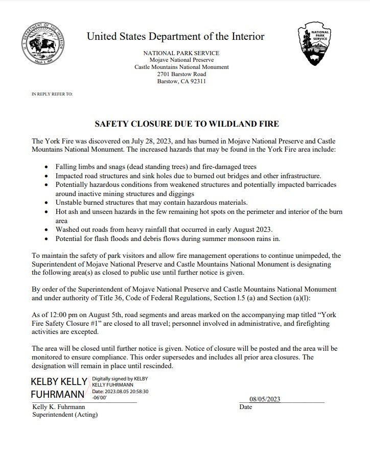
York Fire Area Closure August 6 2023
Related Incident: 2023 - York Fire
Publication Type: Closures
Mojave National Preserve has issued an official closure order for the York Fire area to protect visitors and other members of the public. The justification includes:
- Falling limbs and snags (dead standing trees) and fire-damaged trees
- Impacted road structures and sinkholes due to burned-out bridges and other infrastructure
- Potentially hazardous conditions from weakened structures and potentially impacted barricades around inactive mining structures and diggings
- Unstable burned structures that may contain hazardous materials
- Hot ash and unseen hazards in the few remaining hot spots on the perimeter and interior of the burn area
- Washed out roads from heavy rainfall that occurred in early August 2023
- Potential for flash floods and debris flows during summer monsoon rains
In the next few weeks as remaining fire crews mop up any remaining hot spots in the fire, the preserve will have outside help from other agencies and personnel to assess the region in a Burned Area Emergency Response (BAER).
For your safety, we ask the following:
- Watch out for fire crews, equipment, and helicopter operations in the area
- Watch for washed-out roads or missing culverts
- Stay clear of standing burned vegetation that may fall at any time
- Do not travel into upper Caruthers Canyon
- Drive at slow speeds (25 MPH Max) for avoiding any unexpected hazards in the roadway
- Private land in-holders, please follow the guidelines provided via email to access your property
- Report any unsafe road or other conditions to us at 760-252-6100 or moja_superintendent@nps.gov - if possible, include photos and GPS coordinates
Flat Fire Update 08062023
Related Incident: Flat Fire
Publication Type: News
Size: 33,246 acres
Start Date: July 15, 2023
Point of origin: 2 miles southeast of Agness, OR
Containment: 30%
Total personnel: 841
Resources: 41 engines l 16 crews l 2 bulldozers l 27 water tenders l 4 masticators l 9 helicopters
Highlights: Crews continue to make good progress on mop-up, assess areas for potential contingency lines, and perform aerial ignitions to remove unburned pockets of fuel within the fire perimeter. Weather patterns remain consistent; however, a slight warming and drying trend is anticipated throughout the week. Firefighters remain ready for any potential changes in fire activity.
Today’s Activities: Crews are securing and improving existing containment lines to keep the fire within the current footprint. Firefighters are conducting mop-up to secure lines and actively patrolling all divisions. Structure protection resources remain in place around Agness, actively surveying and conducting structure assessments. The alternate control lines on Forest System Roads (FSR) 1376 (to the south) and 1503, 3313, and 3680 (to the west) continue to be improved. Night-shift resources hold and patrol containment lines. Crews are ready to respond to any new fire starts in the area, if needed. Smoke created by helicopter aerial ignitions in the southwest corner of the fire near the headwaters of Lawson Creek and in the Game Lake area may be visible from surrounding areas.
With increased fire traffic, all motorists are asked to slow down, use headlights, and proceed cautiously, especially on Bear Camp Road.
Weather: Temperatures will be in the mid-80s to low-90s and humidity around 25-35%, with winds out of the northeast on ridges in the morning, transitioning to a northwest flow in the afternoon. The period of daily low humidity is increasing, resulting in drier fuels and increased fire behavior.
Smoke: Smoke may be visible from the surrounding areas. The Smoke Outlook is available at: https://outlooks.wildlandfiresmoke.net/outlook/b74901f7?
Closures: The Rogue River-Siskiyou National Forest (RRSNF) has issued a closure order for the fire area including trails, roads and a portion of the Illinois River. Oak Flat Campground, Game Lake and Wild Horse Campgrounds and Snow Camp Lookout Recreation Rentals are all closed. The Chetco River Road (FSR 1376) and Chetco/Pistol River Road (FSR 1407) are closed. The closure allows for public access to the Big Rock swimming hole on the Illinois River.
Evacuations: Level 1 “Get Ready” evacuation status in place for areas in the vicinity of the Flat Fire. Link to more information: https://tinyurl.com/currycountyem
Restrictions: Fire danger is currently extreme; the RRSNF is implementing Level 2 Public Use Restrictions. More information here: https://tinyurl.com/ueuznr6e
Please follow all fire restrictions to prevent wildfires. Know before you go. Check on whether there are any campfire restrictions at your recreation destination.
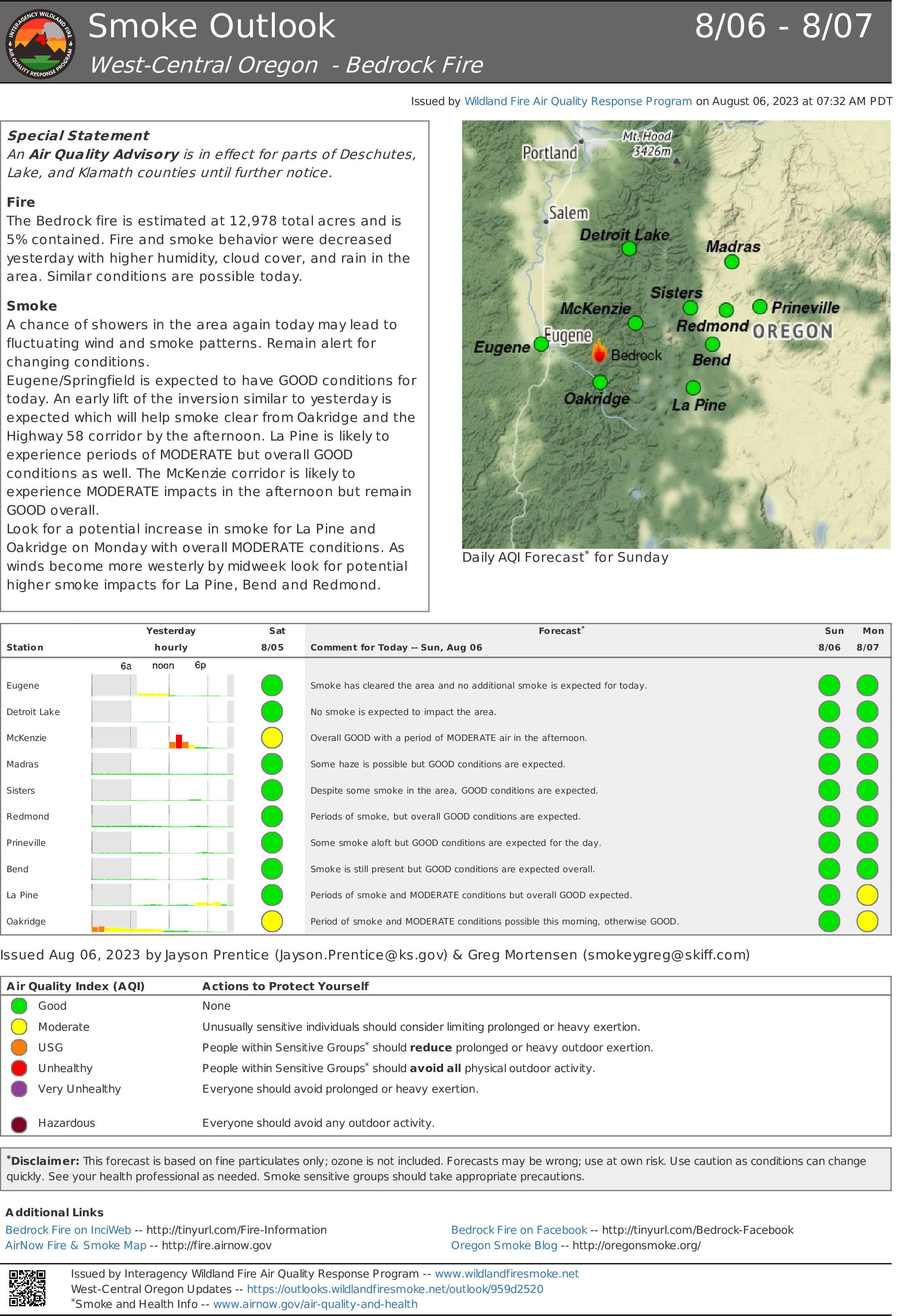
Smoke Outlook for August 6 7 2023
Related Incident: Bedrock Fire
Publication Type: News
Special Statement
An Air Quality Advisory is in effect for parts of Deschutes, Lake, and Klamath counties until further notice.
Fire: The Bedrock Fire is estimated at 12,978 total acres and is 5% contained. Fire and smoke behavior were decreased yesterday with higher humidity, cloud cover, and rain in the area. Similar conditions are possible today.
Smoke: A chance of showers in the area again today may lead to fluctuating wind and smoke patterns. Remain alert for changing conditions.
Eugene/Springfield is expected to have GOOD conditions for today. An early lift of the inversion similar to yesterday is expected which will help smoke clear from Oakridge and the Highway 58 corridor by the afternoon. La Pine is likely to experience periods of MODERATE but overall GOOD conditions as well. The McKenzie corridor is likely to experience MODERATE impacts in the afternoon but remain GOOD overall.
Look for a potential increase in smoke for La Pine and Oakridge on Monday with overall MODERATE conditions. As winds become more westerly by midweek look for potential higher smoke impacts for La Pine, Bend and Redmond.
Spoon Fire Update August 6 2023
Related Incident: Spoon Fire
Publication Type: News
Firefighters Remain on Alert for New Fires as Containment Increases
Cottonwood Ridge, Snake Ridge, Spoon and New Fire Starts – August 6, 2023, Daily Update
Spoon Fire Quick Facts
Acres: 4,560 acres
Cause: Lightning
Containment: 80%
Start Date: July 24, 2023
Location: 2.5 miles east of Highway 60 between Globe and Show Low, AZ. 11 miles southwest of Cedar Creek
Fuels: Piñyon- Juniper, Manzanita, Grass, Cedar
Total personnel for all incidents: 301
Continued hot, dry temperatures, and winds with gusts up to 30 mph occurred Saturday. Crews continued to reinforce containment lines by turning over dirt to make sure there were no hot spots near the perimeter of the fires. Crews were able to increase containment on the Spoon Fire to 80%, and the Cottonwood Ridge fire to 95%.
There was one new fire reported Saturday. The fire was reported two miles south of the old Rodeo-Chediski fire on Chediski Mountain. Crews were sent to the west side of the Fort Apache Reservation to assist with fire suppression operations. With the help of a dozer, crews were able to keep the fire to below 10 acres.
Cottonwood Ridge, Snake Ridge and Spoon fires: The excavators and hand crews continued repairing dozer lines and returning the land back to its natural state. The repair process will continue with the excavators pulling Junipers onto the dozer line and having firefighters cut them up, and then start spreading them across the dozer line, as well as spreading grass seed to help reduce run-off should the area receive rain. This will occur on both the Cottonwood Ridge and Spoon fires. Crews patrolled the perimeter of the Snake Ridge Fire and did not find any heat sources close to the fireline, so the fire has been declared 100% contained. Firefighters will continue to be ready to respond to any new starts.
Weather: Hot weather in the low 90s, dry fuels and wind gusts up to 30 miles per hour are a concern through the weekend. Firefighters will remain prepared to respond to any new fire starts.
Evacuations: None. For awareness regarding evacuations, familiarization with the Ready, Set, Go evacuation model is encouraged. Community members may also sign up for the Navajo County Alert System at https://tinyurl.com/y4vwrasw.
Smoke: Smoke may start to appear if winds stir up any heat sources inside the fire perimeter. For information on smoke and air quality, visit https://www.airnow.gov.
Closures: Highway 60 remains open. The southwest portion of Fort Apache is closed, including all Salt River sites within the closure area.
Fire Restrictions: There are several fire restrictions in place depending on location.
-
Fort Apache Agency: Stage 2 Fire Restrictions - No campfire, fireworks, outdoor smoking, debris burning or discharging of firearms. Power saws cannot be used between 10 am and 8 pm. All motorized travel is restricted to developed roads.
-
Show Low, Navajo County and Apache Sitgreaves National Forests: Stage 1 Fire Restrictions - No campfires (except in developed recreation sites), no smoking outdoors, no welding, no fireworks.
More Information:
Inciweb:
Actualizacin del Incendio Lowline Domingo 6 de Agosto 2023
Related Incident: Lowline Fire
Publication Type: News
Equipo de Gestión de Incidentes del Complejo del área de las Montañas Rocosas 1
Dan Dallas, Comandante del Incidente
Teléfono de Información: 970-648-4470 (publico), 970-765-7123 (medios de comunicación)
Correo electrónico: 2023.lowline@firenet.gov
Horario: 8 a.m. – 8 p.m.
Situación Actual: Ayer, los bomberos observaron un comportamiento de fuego moderado que incluyó la quema de árboles durante gran parte del día y se espera que este comportamiento continúe. El gran trabajo de la última semana se puso a prueba aún más por las condiciones climáticas, lo que brindó a los administradores de incendios una mayor confianza para las condiciones de bandera roja de hoy, seguida la Vigilancia meteorológica de incendios el lunes y martes. El trabajo de hoy reflejará el de ayer, con equipos de bomberos que permanecerán vigilantes, observando los efectos de las condiciones cambiantes en el comportamiento del fuego mientras realizan acciones de supresión de rutina. A medida que se reduzcan los requisitos del trabajo de supresión, algunas cuadrillas estarán posicionadas para el comportamiento del fuego y estarán listas para proporcionar capacidad adicional para el incendio Lowline o una respuesta rápida a un nuevo inicio de fuego.
División A/Z: Se patrullarán las líneas de fuego para garantizar que permanezcan seguras.
División Y: Se establecen líneas de fuego directas e indirectas y los bomberos patrullarán y asegurarán más las líneas según sea necesario. En gran parte de esta división, la actividad de incendios sigue siendo mínima debido a la gran arboleda de álamos. Mañana, los vientos soplarán del oeste y empujarán el fuego hacia sí mismo.
División X: los administradores de incendios continuarán evaluando opciones para confinar el incendio en esta división remota.
División W: Afortunadamente, los bomberos están encontrando fuentes de calor mínimas cerca de la línea de fuego, por lo que no se planean operaciones de disparo adicionales. Hoy, las patrullas de la línea de fuego continuarán.
Protección de Estructuras: Los equipos de protección de estructuras finalizarán las evaluaciones de estructuras y las empaquetarán en un informe que será útil para los administradores locales en caso de una futura emergencia en el área.
Condiciones Climáticas y de Combustibles:
Se espera que la actividad del incendio aumente como parte de la advertencia de bandera roja pronosticada. El secado de los combustibles se ha acelerado en los últimos días con un secado adicional hoy debido a la baja humedad en la mitad de la adolescencia, cielos soleados, temperaturas cálidas en los 70 superiores y condiciones de viento cercanas a las 30 mph.
Evacuaciones, Cierres, y Restricciones de Incendios:
Hay una orden de evacuación previa vigente para CR 727, Mill Creek. No hay otras evacuaciones o evacuaciones previas cerca del incendio. Para obtener información específica sobre evacuación, consulte Manejo de emergencias del condado de Gunnison en http://www.gunnisoncounty.org. Puede registrarse para recibir alertas de emergencia en sus teléfonos u otros dispositivos en: https://bit.ly/3QhZVZg.
Cierres del Sistema Forestal Nacional: https://www.fs.usda.gov/Internet/FSE_DOCUMENTS/fseprd1126172.pdf.
Cierres temporarios del BLM: https://tinyurl.com/5n8s7xee.
Restricciones de Incendios en el condado de Gunnison: ninguno.
Reportes sobre la perspectiva de humo: https://outlooks.airfire.org/outlook/ed63b240
Los incendios forestales son una zona de exclusión aérea para aeronaves no autorizadas, incluidos los drones. Si tu vuelas, nosotros no podemos. Para obtener más información, visite http://knowbeforeyoufly.org.
Estadísticas del Incendio Lowline:
Tamaño: 1816 acres
Contenido: 55%
Personal: 325
Locación: 14 mi. NNW de Gunnison, CO
Reportado: 8:00 am 26 de Julio, 2023
Causa: Relámpago
Para más Información:
Línea Telefónica: 970-648-4470 (publicó), 970-765-7123 (media)
Correo electrónico: 2023.lowline@firenet.gov
InciWeb: https://inciweb.wildfire.gov/incident-information/cogmf-lowline-fire
Facebook: www.facebook.com/GMUGFireInfo