
Golden Fire Daily Evening Update July 30 2023
Related Incident: Golden Fire
Publication Type: News
Last shift for night crews as firefighters look to transfer command Tuesday morning.
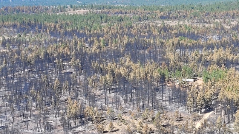
BONANZA, Ore. – Today marks day eight since the Oregon Department of Forestry Incident Management Team 2 (ODF IMT 2) took command of the fire. Deputy Incident Commander Craig Pettinger states, “The fire is in a much different state than when we arrived. The containment and confidence level grows more and more as crews continue to work hard.”
Day shift crews worked on the interior of the fire around the unburned islands of vegetation. Crews also began removing and hauling hose and other tools used for suppression and mopping up. Night shift will patrol the fire, seek hot spots, and continue backhauling hose and other equipment. This will be the last night shift. ODF IMT 2 will transfer command Tuesday morning to a local type 4 team.
The weather for tomorrow will be like today with temperatures in the 80s and light winds. Tuesday, hotter and drier weather will return but with light winds expected. There is a slight chance of thunderstorms on Thursday, with low certainty of precipitation.
Evacuations downgraded as of Thursday, July 27 at 11:00 a.m.:
Level 2 (BE READY)- all areas inside the fire perimeter.
For the most current evacuation information, call the Klamath County hotline at 541-205-9730, and sign up for Klamath County alerts at http://alerts.klamathcounty.org. The American Red Cross are handing out cleaning kits to those affected by the fire. They are located at Living Springs Church, 31601 Mission Street, Bonanza, Oregon 97623.
Recovery Contact Information:
Information for services and resources for those impacted by the community with unmet needs, residential cleanup guidance, disaster social services and donations are available here: https://tinyurl.com/bddatnxv.
Anderson Complex Daily Update for July 30 2023
Related Incident: Anderson Complex
Publication Type: News
Firefighters assigned to the Anderson Complex in the Anderson-Clear area worked Saturday to protect structures and allotments near the Teklanika River Fire (#257), which is now estimated at 3,000 acres. The primary areas of focus were protecting sites on both sides of the Teklanika River and assessing protection needs in the city of Anderson.
The BLM Alaska Fire Service Midnight Sun Hotshots were able to get into the area where the fire crossed to the north side of the river. They worked to protect a group of 8 to 10 structures threatened by the fire, laying hose and installing sprinklers. Large air tankers also dropped retardant to protect structures and allotments on the north side of the fire.
Protecting structures and allotments from the fire on both sides of the river remains a priority on Sunday.
In the city of Anderson, members of the Joint Base Elmendorf-Richardson (JBER) Task Force conducted structure assessments on Saturday. They inspected fuel breaks that have been established or are planned for construction. On Sunday, the JBER Task Force will return to Anderson to open up some of the fuel breaks and lay hose. These precautionary measures are being taken to protect the community from the fire should it move in that direction.
In addition to the Teklanika River Fire, the Anderson Complex includes the Kobe Road Fire (#297), Birch Creek Fire (#285), Nenana River Fire (#288), and Nenana River 2 Fire (#289). All fires in the complex are primarily burning in dense black spruce stands.
The Kobe Road Fire is now estimated at 2 acres. The more accurate acreage estimate is based on increased visibility and reconnaissance flights conducted Saturday evening. The fire showed minimal activity during the most recent reconnaissance flights. No new activity was reported on the Nenana River or Nenana River 2 fires.
The Birch Creek Fire is estimated at 250 acres and is pushing north. The area where it is burning is inaccessible to the engines currently assigned to the fire. Skidgens, which are tracked vehicles, have been ordered to give firefighters the access they need.
Great Basin Team 3, a Type 2 team, assumes command of the Anderson Complex at 8 a.m. Monday, July 31. A Type 2 team has additional personnel and resources tasked with managing complex incidents.
Evacuation Statuses Updated from GO to SET for Areas Impacted by the Diamond Fire Tonto
Related Incident:
Publication Type: Announcement
UPDATE 07/30 - 7:00 PM - Diamond Fire Sunflower, Cross F and Diamond Ranch - GO order lifted. It is OK to return home. Use Caution and follow public safety instructions. Remain in SET: Be Prepared to Take Action!
For public and firefighter safety, the Tonto National Forest closure order will remain in effect to prohibit general public access while fire resources are still actively engaged on the incident.
Lowline Fire Evening Update Sunday July 30 2023
Related Incident: Lowline Fire
Publication Type: News
Rocky Mountain Complex Incident Management Team 1
Dan Dallas, Incident Commander
Information Phone: 970-648-4470 (public), 970-765-7123 (media)
Email: 2023.lowline@firenet.gov
Information Staffing Hours: 8 a.m. to 8 p.m.
Special Note: Burnout operations are carefully planned and initiated only when the right conditions align allowing firefighters to suppress the fire on their terms. A considerable amount of preparation has occurred over the past several days using hand crews and dozers to construct indirect firelines.
The Lowline Fire has generated large amounts of smoke, which can be concerning to communities in the surrounding areas. Although the fire is burning in heavy timber, some of the smoke has been generated from suppression-related burnout operations to the southwest and northeast sides of the fire. This is accomplished by removing vegetation and debris to create a break in fuels.
Current Situation: A Multi-Mission Aircraft (MMA) flew over the fire area earlier today mapping it at 1288 acres. Containment increased to 15%. The fire burned actively in the mixed conifers during the early parts of the day, but heavy clouds and rising humidity subdued fire behavior during afternoon hours.
In Division A, burnout operations continued using hand crews and aerial ignitions. Firefighters continued work on indirect and direct firelines. Structure protection crews scouted and assessed structures within the Division.
Firefighters in Division Z conducted additional burnout operations today to secure the southern fire perimeter. Crews also continued securing the segment of fireline established by yesterday’s burnout operation by patrolling along the fireline and mopping up hot spots.
In Division Y, an engine crew continued to secure existing fireline from yesterday’s burnout operations and was able to continue burning along a small portion of the ridgeline moving westward.
A crew in Division W continued working its way west from Division A burning out some of the fuels from inside the constructed indirect fireline. Structure protection crews continued assessing structure north of the fire.
Weather & Fuel Conditions: There was more cloud cover than anticipated with some precipitation that didn’t impact the fire. Temperatures were lower and relative humidity higher than forecasted.
Evacuations, Closures, and Fire Restrictions:
Mandatory evacuations are in place in the Squirrel Creek and Mill Creek drainages. For specific evacuation information, see Gunnison County Emergency Management at www.gunnisoncounty.org. You may sign up to receive emergency alerts on your phones or other devices at: https://bit.ly/3QhZVZg .
An area, road, and trail closure has been implemented on National Forest System lands near the fire area. For specifics see this link: https://www.fs.usda.gov/Internet/FSE_DOCUMENTS/fseprd1126172.pdf . BLM has implemented a temporary closure in the fire vicinity. For details see this link: www.blm.gov/programs/public-safety-and-fire/fire-and-aviation/regional-information/colorado/southwest-district . County Roads in the fire vicinity are barricaded. In the interest of public safety, fire officials ask visitors to be aware of fire traffic and avoid the area.
There are currently no fire restrictions in Gunnison County. Should restrictions be implemented, they will be posted at this site: https://westslopefireinfo.com/gunnison-county/ .
Wildfires are a no-fly zone for unauthorized aircraft, including drones. If you fly, we can’t. For more information, visit http://knowbeforeyoufly.org.
Lowline Fire Statistics:
Size: 1288 acres
Containment: 15%
Total Personnel: 419
Location: 14 mi. NNW of Gunnison, CO
Reported: 8:00 am July 26, 2023
Cause: lightning
For More Information:
Information Phone: 970-648-4470 (public), 970-765-7123 (media)
Email: 2023.lowline@firenet.gov
InciWeb: https://inciweb.wildfire.gov/incident-information/cogmf-lowline-fire
Facebook: www.facebook.com/GMUGFireInfo
Flat Fire Evening Update 7302023
Related Incident: Flat Fire
Publication Type: News
July 30, 2023
Flat Fire Evening Update
Size: 25,572
Start Date: July 15, 2023
Point of origin: 2 miles southeast of Agness, OR
Containment: 14%
Cause: Human caused, Under Investigation
Total personnel: 1,941
Resources: 53 engines l 50 crews l 8 bulldozers l 35 water tenders l 8 masticators l 12 helicopters
Today’s Progress: In the southwest corner of the fire area, firefighters used aerial ignitions to burn vegetation interior of the fire line. Operations included using Unstaffed Aerial Systems (UAS) and ground-based tools to burn vegetation just interior of the fire line along Forest Service Road (FSR) 3680 south of Game Lake. Helicopters used Plastic Spherical Dispenser (PSD) for aerial firing operations further interior bringing the main fire area southwest towards the fire line. This strategy moves the main fire to the prepared fire line under more favorable and controlled conditions. Firing operations continued along the fire line near Game Lake reducing vegetation along the line closing the remaining gap of open fire line in that area. The northern line of the fire continues to be patrolled for any hot spots. Crews are working on improving the alternate containment lines west of the fire on FSR 3313, 1503, and 3680.
Community Meeting: A community meeting will take place on Monday, July 31st, at 6:00 p.m. at the Brookings-Harbor High School in the cafeteria. The address for the school is: 625 Pioneer Rd, Brookings, OR 97415. The meeting will also be livestreamed on the Flat Fire Facebook page: facebook.com/flatfireoregon2023
Evacuations: A Level 1 “Get Ready” evacuation notice is in effect for areas on the north side of the Rogue River in Agness up to Illahe Lodge and along the Rogue River Corridor from Quosatana Creek Campground to the Agness area. This includes the areas of Spud Road, Old House Creek Road and Oak Flat.
The area immediately east of Agness remains in a level 2 and the remainder of the areas around the fire are Level 2. The Curry County Sheriff’s Office will continue to coordinate with the Fire Incident Management Team and will notify all residents affected by the fire of any reasons to change evacuation levels.
Curry County is using Everbridge to send evacuation notices. You can sign up for notifications here: https://www.co.curry.or.us/departments/emergency_management/index.php.
Weather: The forecast calls for a small increase in temperatures and winds Monday.
Smoke: The Smoke Outlook is available at: https://outlooks.airfire.org/outlook/en/b74901f7
Closures: The Rogue-River Siskiyou National Forest issued an updated closure order on July 29th for the fire area including trails, roads and a portion of the Illinois River. Oak Flat Campground, Game Lake Campground, Wild Horse Campground and Snow Camp Lookout Recreation Rentals are all closed as part of the area closure. The Chetco River Road (FR 1376) and Chetco/Pistol River Road (FR 1407) are now closed. The updated closure also allows for public access to the Big Rock swimming hole on the Illinois River. More information can be found here: https://tinyurl.com/bdzbae69
Restrictions: Fire Restrictions are in place, to learn more visit: fs.usda.gov/rogue-siskiyou
Abnormally dry conditions and hot temperatures are forecast to persist across Oregon and Washington with vegetation already much drier than normal. Please follow all fire restrictions, especially as we are seeing a significant increase in human-caused fire starts across the region.
Use properly functioning spark arresters and stay on designated trails and roads. Do not park, idle or drive on dry, flammable vegetation. Your vehicle could start a wildfire.
York Fire Update 73023 330PM
Related Incident: 2023 - York Fire
Publication Type: News
The fire has crossed over into the State of Nevada.
For timely and accurate information please continue to monitor the York Fire InciWeb page.
Classic Canyon Fire Daily Update July 30 2023
Related Incident: Classic Canyon Fire
Publication Type: News
July 30, 2023
5:00 pm
Size: 235 acres
Containment: 85%
Date Started: July 27, 2023
Cause: Unknown
The Texas A&M Forest Service (TAMFS) in coordination with the Texas Intrastate Fire Mutual Aid System Strike Team (TIFMAS), McGregor Task Force (TF) and the Gatesville Volunteer Fire Department began work on July 27th to contain the Classic Canyon Fire. On July 28th, fire activity was low, dozer containment lines were completed and engine crews continued patrol and mop up. At end of shift, there was 65% containment.
Yesterday:
The McGregor TF dozer and operator were released from the Classic Canyon Fire at 9:00am on July 29th. The TIFMAS and McGregor TF engine crew continued patrolling and holding the fireline. By 11:00 am, the McGregor engine crew was released and the fire was transitioned to new Incident Commander K. Cole. The fire perimeter has been more accurately mapped and now shows fire size to be 235 Acres. 85% containment at end of shift.
Today:
At 9:00am on July 30th, Incident Commander K. Cole with the McGregor TF transferred command to D. Pennington with TAMFS. Three engines from the McGregor TF and three from the TAMFS Strike Team are patrolling the containment area and extinguishing any hot areas along the line. Containment still at 85%
Weather and Fire Behavior:
Hot and dry conditions are expected to continue through Monday with high temperatures near 103 and minimum humidity between 20-25%. Today, light winds from the southwest will shift to southeasterly later in the day and relative humidity recovery is expected to be around 60% by early Monday morning.
Wildfire potential will remain high for a broad area of Texas through the end of next week as the strong area of high pressure continues to assert its dominance over Texas. Temperatures of 100-105°F will continue to drive moisture out of live and dead fuel nearly statewide, increasing the scope of dry to critically dry fuel that can support wildfire activity. Periods of elevated fire weather combined with dry to critically dry fuel beds will support moderate potential for significant fires that are highly resistant to control efforts for the Western/Eastern Hill Country, Cross Timbers, Southeast Texas, Western Pineywoods, and Central Texas. Fuel dryness continues to build north and west across Texas, expanding the risk of increased wildfire activity into regions that have had limited wildfire activity in July.
Informe matutino para el incendio Flat 30 de Julio 2023
Related Incident: Flat Fire
Publication Type: News
30 de Julio, 2023
Informe matutino para el incendio Flat
Inicio:15-Julio-2023
Extension: 25,572
Localizacion: 2 millas Sureste de Agness, OR
Contención: 14%
Causa: Error Humano, bajo investigación
Personal: 1,941
Recursos: 53 camiones de bomberos l 50 escuadrillas de bomberos l 8 buldóceres l 35cisternas l 8 máquinas masticadoras l12 helicópteros
Situación Actual: Los bomberos están enfocándose en la seguridad de los trabajadores y del publico en general y en mantener el tamaño del incendio lo más pequeño posible. Las operaciones de incendio se dan dependiendo de las condiciones climáticas, tipo de vegetación y topografía. Además, son solamente una parte de la estrategia en general. Dichas operaciones han sido completadas al Sur de Game Lake sobre la carretera Forestal (FR) 3680 a lo largo del borde del camino. Una evaluación aérea infrarroja de alta resolución ha mostrado muy pocas zonas de emanación de calor sobre el flanco Noreste del incendio. Por esta razón, se ha realizado una pausa en las operaciones de incendio. Las evaluaciones en la infraestructura han sido concluidas en el área de Lobster Creek. Sobre el lado Oeste, las carreteras FR 3313, 1503 y 3680 se han preparado como líneas alternativas. Se continua con el trabajo en Burnt Ridge como una línea alternativa de contención.
Actividades en el día de hoy: En altas horas de la noche, fueron completadas las operaciones de quema sobre el lado Suroeste del fuego, a lo largo del borde de FR 3680. Lo esfuerzos para el día de hoy estarán enfocados en profundizarse mas en la misma área con el objetivo de fortalecer las líneas. Se ha dado comienzo al patrullaje y limpieza sobre las líneas Noreste de contención. Se utilizarán los recursos aéreos para localizar e inhibir cualquier espacio emanando calor sobre los flancos Noreste, Este y Sur. Hasta el momento, los esfuerzos realizados para proteger la infraestructura han dado buenos resultados. El día de hoy, se estará trabajando sobre al Norte de Agness. Se continua con la preparación de las líneas alternativas en el lado Oeste, utilizando las carreteras forestales FR 3313, 3680, y 1503. Así mismo, se continuará con el mismo tipo de labor al Este y usando Burnt Ridge.
Debido al tráfico vehicular de bomberos, se les pide a todos los motoristas atravesando la carretera de Bear Camp Road que manejen despacio, usando sus focos delanteros y conducir con precaución.
Reunión Comunitaria.
Se estará llevando a cabo una reunión para la comunidad el lunes 31 de Julio, en la cafetería de la escuela secundaria en Brookings, a las 6:00pm. La dirección es: 625 Pioneer Rd, Brookings, OR 97415.
Evacuaciones: Permanece en efecto el Nivel de Evacuación 1 “Listos” para las áreas en el lado Norte de Rogue River en Agness hacia Illahe Lodge y a lo largo del corredor de Rogue River desde el campamento de Quosatana Creek hasta el área de Agness. Incluyendo las zonas de Spud Road, Old House Creek Road y Oak Flat.
El área Este, cercana a Agness permanece a un Nivel de Evacuación 2 debido al peligro extremado que el incendio representa.
Ciertas áreas que se encuentran en las afueras de la zona quemada hacia el Suroeste permanecerán a un Nivel de Evacuación 2 mientras los bomberos continúen asegurando más las líneas de control. La Oficina del Alguacil para la ciudad de Curry continuara coordinándose con el Grupo para el Manejo de Incidente de Incendio y serán los responsables de notificar a los residentes afectados por el incendio acerca de las razones para cambiar los niveles de evacuación.
La ciudad de Curry está enviando noticias de evacuación utilizando el sistema Everbridge. Usted puede registrarse en:
https://www.co.curry.or.us/departments/emergency_management/index.php
Condiciones climáticas: El pronóstico del tiempo para el día de hoy, está avisando condiciones climáticas cálidas y secas con un incremento en la temperatura y en los vientos.
Impacto del humo: Pronósticos en la presencia del humo, puede encontrarse en la página web: https://outlooks.airfire.org/outlook/en/b74901f7
Cierres de áreas: El Bosque Nacional de Rogue River-Siskiyou, ha emitido una orden de cierre en el área del incendio la cual incluye senderos, carreteras y parte del rio Illinois. Esta orden de cierre abarca Oak Flat Campground, Game Lake Campground, Wildhorse Campground y el Lookout Recreacional de Snow Camp. Actualmente se encuentran cerradas la carretera forestal de Chetco River Road (FR 1376) y la de Chetco/Pistol River Road (FR 1407). Esta nueva orden de cierre permitirá al público el acceso a el área para nadar de Big Rock en el Rio Illinois.
Puede encontrar información actualizada en : https://tinyurl.com/bdzbae69
Orden de restricción: Se han establecido Restricciones en el área. Para más información:
Se pronostican condiciones climáticas anormalmente secas y temperaturas calientes en una manera persistente a través de Oregon y Washington. Estas áreas ya presentan vegetación más seca de lo normal. Por favor siga todas las restricciones de incendio, especialmente después de observarse a nivel regional un incremento significativo en incendios causados por humanos.
Utilice supresores de chispas que estén funcionando apropiadamente y permanezca en senderos y caminos designados. No se parquee, descanse o maneje sobre vegetación inflamable. Su vehículo podría iniciar un incendio forestal.
York Fire Update 73023 200pm
Related Incident: 2023 - York Fire
Publication Type: News
The York Fire is currently at 70,000 acres and 0% containment. The increased fire activity observed yesterday is also being seen today, as winds have begun to pick up and are starting to exacerbate the fire’s behavior. Dealing with constant and unpredictable wind patterns can pose significant challenges for firefighting crews attempting to establish containment lines.
These types of winds can cause the fire to spread more rapidly and unpredictably. South winds are pushing the fire north. And the changing speeds along with the shifting directions from east to west can result in erratic fire behavior, causing the fire to advance. Currently, the fire is moving toward the Nevada State border.
The collaborative effort to combat the York Fire by bringing together resources from various agencies is a testament to the response during wildfire emergencies. The involvement of the National Park Service, Bureau of Land Management, San Bernardino County Fire Protection District, and Clark County Fire highlights the scale and severity of the fire and the need for extensive resources to tackle it effectively.
The information staff of the York Fire is working closely with Clark County Communications to provide timely and accurate information to the public the fire effects. If you have any questions regarding what is occurring specifically with the residential areas of Nipton and Searchlight, please reference Clark County Social www.clarkcountynv.gov/government/departments/public_communications/index.phpcountynv.gov or their twitter at @clarkCountyNV.
WEATHER: Winds and high temperatures with thunder cells to the northwest of the fire.
EVACUATIONS: No current evacuations.
PARK CLOSURE: Ivanpah, Hart Mine Road, and Walking Box Ranch Roads CLOSED in Mojave and Castle Mountains due to hazardous wildfire conditions and fire suppression operations. Please stay clear of the area. Mojave National Preserve is also under Fire Restrictions, please visit their website for more information on restrictions and closures: https://www.nps.gov/moja/index.htm.
Settings - change map background and toggle additional layers
Filter - control incident types displayed on map.
Zoom to your location
Reset map zoom and position
Could not determine your location.
Show Legend
 Wildfire
 Prescribed Fire
 Burned Area
Response
Burned Area
Response Other
Other