
Flat Fire Evening Update 7292023
Related Incident: Flat Fire
Publication Type: News
July 29, 2023
Flat Fire Evening Update
Size: 24,951
Start Date: July 15, 2023
Point of origin: 2 miles southeast of Agness, OR
Containment: 14%
Cause: Human caused, Under Investigation
Total personnel: 1,941
Resources: 53 engines l 50 crews l 8 bulldozers l 35 water tenders l 8 masticators l
12 helicopters
Today’s Progress: Firing operations continued on the Flat Fire today where conditions allowed. On the southeast corner, firefighters made steady progress with tactical burning from Forest Road (FR) 420 down toward Snow Camp. In the fire’s interior between FR 3318 and FR 3680, South of Wildhorse Ridge, fireline was strengthened through interior burning using Unstaffed Arial Systems (UAS). The night shift plans to deepen fireline through burning operations in the northeast corner of the fire area.
With fire traffic on Bear Camp Road, all motorists on Bear Camp Road are asked to slow down, use headlights and proceed with caution.
Community Meeting: A community meeting will take place on Monday, July 31st, at 6:00 p.m. at the Brookings-Harbor High School in the cafeteria. The address for the school is: 625 Pioneer Rd, Brookings, OR 97415.
Evacuations: A Level 1 “Get Ready” evacuation notice is in effect for areas on the north side of the Rogue River in Agness up to Illahe Lodge and along the Rogue River Corridor from Quosatana Creek Campground to the Agness area. This includes the areas of Spud Road, Old House Creek Road and Oak Flat.
The area immediately east of Agness remains in a level 2, out of an abundance of caution. Some areas outside the burn area to the southwest will remain in Level 2 while fire crews continue to further secure control lines. The Curry County Sheriff’s Office will continue to coordinate with the Fire Incident Management Team and will notify all residents affected by the fire of any reasons to change evacuation levels. Curry County is using Everbridge to send evacuation notices. You can sign up for notifications here: https://www.co.curry.or.us/departments/emergency_management/index.php.
Weather: The forecast calls for continued warm and dry weather conditions into Sunday, with an increase in temperatures and winds Monday.
Smoke: The Smoke Outlook is available at: https://outlooks.airfire.org/outlook/en/b74901f7
Closures: The Rogue-River Siskiyou National Forest has issued an updated closure order for the fire area including trails, roads and a portion of the Illinois River. Oak Flat Campground, Game Lake Campground, Wild Horse Campground and Snow Camp Lookout Recreation Rentals are all closed as part of the area closure. The Chetco River Road (FR 1376) and Chetco/Pistol River Road (FR 1407) are now closed. The updated closure also allows for public access to the Big Rock swimming hole on the Illinois River. More information can be found here: https://tinyurl.com/bdzbae69
Restrictions: Fire Restrictions are in place, to learn more visit: fs.usda.gov/rogue-siskiyou
Abnormally dry conditions and hot temperatures are forecast to persist across Oregon and Washington with vegetation already much drier than normal. Please follow all fire restrictions, especially as we are seeing a significant increase in human-caused fire starts across the region.
Use properly functioning spark arresters and stay on designated trails and roads. Do not park, idle or drive on dry, flammable vegetation. Your vehicle could start a wildfire.
Fire Information:(541)216-4579 Media inquiries: (541)237-6369 Email: 2023.flat.or@firenet.gov
Golden Fire Daily Evening Update July 29 2023
Related Incident: Golden Fire
Publication Type: News
Fire remains in footprint despite multiple flare-ups.
BONANZA, Ore. – Firefighters were ready for critical fire weather conditions today with the expected Red Flag Warning over the fire area. Gusty winds, low relative humidity, and high temperatures tested the work that firefighters completed. There were some internal “flare-ups” well within the fire that crews managed quickly. Crews responded to and extinguished several flare-ups in brush and grass.
For the remainder of the fire, crews will focus on gridding and seek and destroy missions to extinguish any existing heat. Confidence in containment continues to grow as more depth is gained in mop up operations. Tonight, crews will use infrared cameras throughout the fire area identifying hot spots. Heat is not always seen with the naked eye, so having handheld heat detection tools helps locate problem areas.
The hot, dry weather is expected to ease tomorrow. The forecast calls for temperatures in the low 80s and minimal wind. Lightning is expected late next week with a small chance of showers. Higher nighttime relative humidity will complement the crews’ work. Evacuations downgraded as of Thursday, July 27 at 11:00 a.m.:
Level 2 (BE READY)- all areas inside the fire perimeter.
For the most current evacuation information, call the Klamath County hotline at 541-205-9730, and sign up for Klamath County alerts at http://alerts.klamathcounty.org. The American Red Cross is handing out cleaning kits to those affected by the fire. They are located at Living Springs Church, 31601 Mission Street, Bonanza, Oregon 97623.
Recovery Contact Information for services and resources for those impacted by the community with unmet needs, residential cleanup guidance, disaster social services and donations are available here: https://tinyurl.com/bddatnxv.
Actualizacin del Incendio Lowline Sbado 29 de Julio 2023
Related Incident: Lowline Fire
Publication Type: News
Equipo de Gestión de Incidentes del Complejo del área de las Montañas Rocosas 1
Dan Dallas, Comandante del Incidente
Teléfono de Información: 970-648-4470 (publico), 970-765-7123 (medios de comunicación)
Correo electrónico: 2023.lowline@firenet.gov
Horario: 8 a.m. – 8 p.m.
Nota Especial: Los bomberos suelen utilizar una táctica de supresión de incendios forestales conocida como "contrafuego". Los cortes de combustible o "líneas de fuego indirectas" se crean antes de la ignición. El trabajo se realiza utilizando uno o una combinación de recursos, como cuadrillas de mano, topadoras, caminos y senderos, y barreras naturales, como grandes afloramientos rocosos y cumbres. El trabajo preparatorio brinda a los bomberos la oportunidad de realizar un encendido controlado y combatir incendios forestales en sus términos mientras cumplen los objetivos operativos para reducir el riesgo para las estructuras y otros valores en riesgo.
Situación actual: Un vuelo infrarrojo anoche proporcionó una evaluación más precisa del incendio Lowline. El fuego ahora se encuentra a 996 acres y está 7% contenido. El fuego está ardiendo activamente en madera pesada con manchas y quema de árboles. Queda suficiente humedad en los combustibles ligeros para impedir que el fuego se propague por el pasto y la artemisa.
En División A, los bomberos realizaron una operación de quema en el lado este de la División A. Las técnicas de encendido incluyeron el uso de un helicóptero que arrojaba esferas en forma de ping pong, conocidas como ignición demorada aérea, sobre el área objetivo y bomberos con antorchas de goteo en el suelo. Un equipo estará en el lugar para patrullar el área durante la noche.
La cuadrilla de la División Z continuó con las operaciones de limpieza para reforzar y mantener la línea de fuego directa a lo largo del flanco sur. También realizaron evaluaciones de estructuras y comenzaron a planificar la implementación de protección de estructuras alrededor de las estructuras.
En la División Y, a lo largo de la cumbrera se está produciendo una combinación de construcción de línea indirecta manual y con topadora a lo largo de la cresta al oeste del incendio. Las cuadrillas hicieron algunos trabajos de preparación para una posible operación de quema mañana.
Los bomberos de la División W trabajaron en la construcción de una línea de fuego indirecta en preparación para futuras operaciones de quemado para reforzar esas líneas y evitar que el fuego se propague más.
Condiciones del Clima y Combustibles:
Mañana estará mayormente nublado con la posibilidad de lluvia y actividad de tormenta eléctrica sobre el área del incendio. Las temperaturas se mantendrán entre los medios y altos 80 con un pequeño aumento en la humedad relativa. Posibles ráfagas de viento pueden ocurrir durante la actividad de tormentas eléctricas.
Evacuaciones, Cierres, y Restricciones de Incendios:
Se han realizado evacuaciones obligatorias en los drenajes de Squirrel Creek y Mill Creek. Para obtener información específica sobre evacuación, consulte Manejo de emergencias del condado de Gunnison en www.gunnisoncounty.org. Puede registrarse para recibir alertas de emergencia en sus teléfonos u otros dispositivos en: https://bit.ly/3QhZVZg.
Se ha implementado cierre de áreas, caminos y senderos en tierras del Sistema Forestal Nacional cerca del incendio. Para obtener detalles, consulte este enlace: https://www.fs.usda.gov/Internet/FSE_DOCUMENTS/fseprd1126172.pdf. Las carreteras del condado en la vecindad del incendio están bloqueadas. Se le pide al público que se adhiera al cierre por salud pública y seguridad de nuestro personal de bomberos.
La oficina local de BLM Gunnison implementó una orden de cierre temporal para todos los usos públicos de 978 acres de terreno público, desde Cunningham Gulch hacia el norte hasta Mill Creek Road (Gunnison County Road 727) en respuesta al incendio Lowline, que arde activamente en el Bosque Nacional Gunnison alrededor de 14 millas al noroeste de Gunnison y 11 millas al suroeste de Crested Butte en el condado de Gunnison, CO. La orden, el mapa y otros avisos se publican en: https://www.blm.gov/.../regio.../colorado%20/distrito-suroeste.
Actualmente no hay restricciones de incendios en el condado de Gunnison. Si se implementan restricciones, se publicarán en este sitio: https://westslopefireinfo.com/gunnison-county/.
Los incendios forestales son una zona de exclusión aérea para aeronaves no autorizadas, incluidos los drones. Si tu vuelas, nosotros no podemos. Para obtener más información, visite http://knowbeforeyoufly.org.
Estadísticas del Incendio Lowline:
Tamaño: 996 acres
Contenido: 7%
Personal: 322
Locación: 14 mi. NNW de Gunnison, CO
Reportado: 8:00 am 26 de Julio, 2023
Causa: Relámpago
Para mas Informaccion:
Línea Telefónica : 970-648-4470 (public), 970-765-7123 (media)
Correo electrónico: 2023.lowline@firenet.gov
InciWeb: https://inciweb.wildfire.gov/incident-information/cogmf-lowline-fire
Facebook: www.facebook.com/GMUGFireInfo
FINAL Newell Road Fire Update July 29
Related Incident: NEWELL ROAD
Publication Type: News
Final Update, July 29, 2023
Newell Road Fire
Beginning Saturday, July 30, at 6:00 AM:
Fire Information Phone: 509-773-0570
Non-Emergency (to report smoke or fire activity) 509-773-4545
Email: emergencymanagement@klickitatcounty.org
Facebook: https://www.facebook.com/KlickitatDEM911
Inciweb: inciweb.wildlfire.gov/newellroad
Estimated size: 60,551 acres
Containment: 100%
Start Date: July 21, 2023
Area of Origin: Klickitat County near Newell Road
Cause: Under Investigation
Structures Damaged: Currently being assessed
Northwest Incident Management Team 8 (NWIMT8) would like to take this opportunity to thank the community, cooperators, and firefighters for the unwavering support during our management of the Newell Road Fire. This will be the last fire update from the NWIMT8.
Fire Update: The final shift focus was on suppression repair work addressing dozer lines, downed fences, and monitoring/patrol activities. All fire personnel deployed out of Goldendale today. Fire managers will continue to demobilize resources throughout the day.
Tomorrow’s planned activity: NWIMT8 will return management of the fire to local fire and agency resources at 6:00 AM. Each remaining agency will provide their own resources for their assigned section of the fire, which will include patrolling and monitoring. Some smoke will likely remain visible, but if you see active fire near the control lines in the coming days, call 911 or the area non-emergency line 509-773-4545 and local dispatchers will direct those calls as needed – IMT8 fire information phone lines will be disconnected at 8 PM tonight, and future Facebook and email communications will be distributed through the Klickitat DEM Facebook and website.
Evacuations: For the latest evacuation information, please see: https://www.klickitatcounty.org/249/Emergency-Management.
Road closure updates: Please refer to the Klickitat DEM Facebook and website for the most current closure information: https://www.klickitatcounty.org/249/Emergency-Management.
Temporary Flight Restriction (TFR): TFR has been released.
Lowline Fire Evening Update Saturday July 29 2023
Related Incident: Lowline Fire
Publication Type: News
Rocky Mountain Complex Incident Management Team 1
Dan Dallas, Incident Commander
Information Phone: 970-648-4470 (public), 970-765-7123 (media)
Email: 2023.lowline@firenet.gov
Information Staffing Hours: 8 a.m. to 8 p.m.
Special Note: Firefighters commonly use a wildland fire suppression tactic known as “burning out.” Fuel breaks or “indirect firelines” are created prior to ignition. The work is done by utilizing a combination of resources such as hand crews, dozers, roads, trails, and natural barriers such as large rock outcroppings and ridgetops. The preparatory work provides firefighters with an opportunity to conduct a controlled ignition and fight wildfires on their terms while meeting operational objectives reducing the risk to structures and other values at risk.
Current Situation: An infrared flight last night provided a more accurate size-up of the Lowline Fire. The fire now stands at 996 acres and is 7% contained. The fire is actively burning in heavy timber with spotting and tree torching. Enough moisture remains in the light fuels to hinder the fire from spreading in the grass and sagebrush.
In Division A, firefighters conducted a burnout operation on the east side of Division A. Ignition techniques included the use of a helicopter dropping ping pong shaped spheres, known as delayed aerial ignition devices, over the target area and firefighters with drip torches on the ground. A crew will be in place to patrol the area overnight.
Crews in Division Z continued mop up operations to reinforce and hold direct fireline along the southern flank. They also conducted structure assessments and started planning for implementing structure protection around structures.
In Division Y a mixture of indirect hand and dozer line construction is occurring along the ridge to the west of the fire. Crews did some preparation work for a possible burnout operation tomorrow.
Division W firefighters worked on constructing indirect fireline in preparation future burnout operations to reinforce those lines and hold the fire from spreading further.
Weather & Fuel Conditions:
It will be mostly cloudy tomorrow with a possibility of some wetting rain and thunderstorm activity over the fire area. Temperatures will remain in the mid to low 80s with a small rise in relative humidity. Potential gusty winds can occur during thunderstorm activity.
Evacuations, Closures, and Fire Restrictions:
Mandatory evacuations are in place in the Squirrel Creek and Mill Creek drainages. For specific evacuation information, see Gunnison County Emergency Management at www.gunnisoncounty.org. You may sign up to receive emergency alerts on your phones or other devices at: https://bit.ly/3QhZVZg .
An area, road, and trail closure has been implemented on National Forest System lands near the fire area. For specifics see this link: https://www.fs.usda.gov/Internet/FSE_DOCUMENTS/fseprd1126172.pdf . County Roads in the fire vicinity are barricaded. In the interest of public safety, fire officials ask visitors to be aware of fire traffic and avoid the area.
The BLM Gunnison Field office implemented a temporary closure order to all public use for 978 acres of public land, from Cunningham Gulch north to Mill Creek Road (Gunnison County Road 727) in response to the Lowline Fire, actively burning in Gunnison National Forest about 14 miles north-northwest of Gunnison and 11 miles southwest of Crested Butte in Gunnison County, CO. The order, map and other notices are posted at: https://www.blm.gov/.../regio.../colorado/southwest-district.
There are currently no fire restrictions in Gunnison County. Should restrictions be implemented, they will be posted at this site: https://westslopefireinfo.com/gunnison-county/ .
Wildfires are a no-fly zone for unauthorized aircraft, including drones. If you fly, we can’t. For more information, visit http://knowbeforeyoufly.org.
Lowline Fire Statistics:
Size: 996 acres
Containment: 7%
Total Personnel: 322
Location: 14 mi. NNW of Gunnison, CO
Reported: 8:00 am July 26, 2023
Cause: lightning
For More Information:
Information Phone: 970-648-4470 (public), 970-765-7123 (media)
Email: 2023.lowline@firenet.gov
InciWeb: https://inciweb.wildfire.gov/incident-information/cogmf-lowline-fire
Facebook: www.facebook.com/GMUGFireInfo
Bedrock Fire Emergency Closure Order July 29 2023
Related Incident: Bedrock Fire
Publication Type: Closures
The Willamette National Forest has announced an updated closure order for a portion of the Forest around the Bedrock Fire as of July 29, 2023. Please see the attached closure order and map for further details.
BLM issues Temporary Closure Order for public lands in Gunnison Field Office July 29 2023
Related Incident: Lowline Fire
Publication Type: Announcement
BLM issues Temporary Closure Order for public lands in Gunnison Field Office
GUNNISON, Colo. – The Bureau of Land Management has implemented a temporary closure to all public use for 978 acres of public land in Gunnison Field Office, from Cunningham Gulch north to Mill Creek Road (Gunnison County Road 727). Gunnison Field Manager Jon Kaminsky issued the Temporary Closure Order in response to the Lowline Fire, actively burning in Gunnison National Forest about 14 miles north-northwest of Gunnison and 11 miles southwest of Crested Butte in Gunnison County, CO. The BLM closure provides for increased public safety and enables firefighters to focus on suppression efforts, and will remain in effect until firefighting operations are completed and safe public access is ensured.
“While our hope is that the Lowline Fire is contained without spreading to BLM-managed lands, the safety of visitors, residents, and fire crews remains our top priority,” said Jon Kaminsky. “We are working closely with the U.S. Forest Service, Gunnison County, and the Incident Management Team to monitor and address the situation.”
The Lowline Fire is a lightning-ignited wildfire first reported on July 26. The fire has burned close to 800 acres along a ridge at about 9,400 feet, primarily in mixed conifer forest, including heavy dead and down fuels, along with grasses and shrubs. The U.S. Forest Service issued a Forest Closure Order on July 27. In addition, Gunnison County issued mandatory evacuations for residents in the Squirrel Creek and Mill Creek drainages. Rocky Mountain Complex Incident Management Team 1 assumed management responsibility for the fire under Incident Commander Dan Dallas. Firefighting resources are focused on minimizing impacts to structures and other values at risk. Containment is currently estimated at 1%.
Current information on the Lowline Fire is available online at https://inciweb.nwcg.gov/incident- information/cogmf-lowline-fire. BLM Southwest District fire notices are posted online at https://www.blm.gov/programs/public-safety-and-fire/fire-and-aviation/regional- information/colorado/southwest-district and on https://www.facebook.com/BLMMontroseFireUnit. The BLM reminds the public that wildfires are a no-fly zone for unauthorized aircraft, including drones. Remember—“if you fly, we can’t.” For more information, visit http://knowbeforeyoufly.org.
- BLM -
BLM Gunnison Field Office Temporary Order July 28 2023
Related Incident: Lowline Fire
Publication Type: Closures
The Bureau of Land Management has implemented a temporary closure to all public use for 978 acres of public land in Gunnison Field Office, from Cunningham Gulch north to Mill Creek Road (Gunnison County Road 727) in response to the Lowline Fire, actively burning in Gunnison National Forest about 14 miles north-northwest of Gunnison and 11 miles southwest of Crested Butte in Gunnison County, CO. The BLM closure provides for increased public safety and enables firefighters to focus on suppression efforts and will remain in effect until firefighting operations are completed and safe public access is ensured.
For complete information, download a copy of the order and map from the links below.
York Fire Update 72923 426pm
Related Incident: 2023 - York Fire
Publication Type: News
The York Fire is estimated around 30,000 acres and 0% containment. The fire continues to move in a northern direction. The wind-driven weather is having a significant impact on fire behavior. When strong winds interact with the fire, it can lead to extreme fire behavior, making the fire much more dangerous and challenging to control. The collaboration between ground crews and aerial resources is ongoing in the firefighting operations. Their combined efforts are essential in gaining control of the fire and mitigating its impact.
No currently closures or evacuations at this time.
2023 York Fire 7-29-23
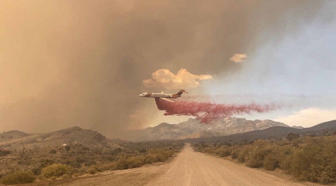
Sat, 07/29/2023 - 19:32
Aircraft dropping retardant on the York Fire North end of the fire. 7-29-23
Settings - change map background and toggle additional layers
Filter - control incident types displayed on map.
Zoom to your location
Reset map zoom and position
Could not determine your location.
Show Legend
 Wildfire
 Prescribed Fire
 Burned Area
Response
Burned Area
Response Other
Other