
Gunnison County Sheriff Evacuation Orders July 26 2023
Related Incident: Lowline Fire
Publication Type: Closures
Order of the Sheriff Regarding the Lowline Fire
7/26/2023 5:00 PM: A MANDATORY EVACUATION due to a WILDFIRE for residents in the Mill
Creek Drainage West of the intersection of County Road 730 and 727. LEAVE NOW. Call 970-641- 7607 for more information.
7/26/2023 6:30pm: A PRE-EVACUATION NOTICE for residents along CR 818 to the intersection with CR 730 (Ohio Creek) due to a WILDFIRE. Gather important items to be ready to evacuate if a notice is issued. Evacuate large animals to the Gunnison County Fairgrounds. Call 970-641-7607 for more information.
Respectfully,
/s/ Adam W. Murdie
Sheriff Adam W. Murdie
Rock Pile Fire Daily Update July 29 2023
Related Incident: Rock Pile Fire
Publication Type: News
July 29, 2023
4:00 pm
Size: 180 acres
Containment: 100%
Date Started: July 26, 2023
Cause: Unknown
On July 26th, Texas A&M Forest Service crews, air support and equipment began working with the Texas Intrastate Fire Mutual Aid System Strike Team (TIFMAS) and local fire departments to contain the Rock Pile Fire. Due to the rugged terrain in the area, a large air tanker arrived on July 27th to provide additional flame retardant and an Emergency Medical Technician Team with a Rapid Extraction Module arrived from Kerrville to assist with any injuries. No injures were reported and no structures were damaged.
Yesterday:
At 1:00pm, some heat was still visible within the fire containment area of the Rock Pile Fire. Engine crews continued patrolling the fire perimeter and extinguished all burning material near the containment lines. At end of shift, containment was estimated at 75% and most personnel were released from the fire.
Today:
Incident Commander (IC) K. Wolf and one engine returned to assess fire this morning. After finishing the fireline check at 11:57 am, the IC declared fire 100% contained. The Rock Pile Fire has been turned over to the local fire department, and it will remain open until end of shift on August 1st.
Weather and Fire Behavior:
Southeasterly wind gusts will continue through the evening, peaking around 30 mph in the 10 PM -midnight time frame and dropping off a few hours before sunrise. This afternoon it was slightly cooler with a high temperature of around 88 degrees. Skies mostly sunny today with increasing cloud coverage this evening. Humidity will fall to around 20 percent with fairly decent recovery tonight of around 64 percent. Tomorrow will have a similar forecast as today, with southeasterly winds becoming gusty in the afternoon and peaking late Sunday night. There is an increase in precipitation chances, with an isolated thunderstorm possible in the Davis Mountains late afternoon/early evening on Sunday. This storm may bring gusty and erratic winds, as well as the threat of lightning.
Blum Fire Daily Update July 29 2023
Related Incident: Blum Fire
Publication Type: News
Blum Fire Update July 29, 2023
July 29, 2023
11:30 am
Size: 300 acres
Containment: 50%
Date Started: July 26, 2023
Cause: Unknown
The Blum Fire started on July 26, 2023, and was responded to by multiple fire departments initially. Texas A&M Forest Service was requested for assistance at 3:15 p.m. and responded with aviation resources, heavy equipment, and engines from Texas A&M Forest Service and Texas Intrastate Fire Mutual Aid System (TIFMAS). Multiple departments from Hill, Johnson, and Bosque counties are working in Unified command with Texas A&M Forest Service, and Texas Division of Emergency Management (TDEM).
Yesterday: Aviation resources and heavy equipment were able to add additional containment lines and continue working on suppression of fire activity within the containment lines. Crews worked to suppress hot spots and improved structure protection within the fire area.
Today: Engine crews will be patrolling the perimeter of the fire and the interior roads, working to suppress any active flames, smoking areas and to conduct mop up operations. Heavy equipment from Texas A&M Forest Service is continuing to construct and improve the containment lines. As the day warms and dries, equipment will continue to be ready if fire activity increases. Aerial resources are standing by in case they are needed for suppression.
Weather and Fire Behavior: Moderate winds with higher gusts will continue today and through the weekend. High temperatures and low relative humidity, similar to yesterday’s conditions will continue for the next several days.
Structures: It was initially reported that five homes were destroyed by the Blum Fire in Hill County. After further assessment of the burned area, this was determined not to be true. No homes have been destroyed by the fire. One outbuilding, however, is confirmed to have been lost to the fire.
Evacuations: No evacuations are in effect.
Closures: There are no closures for the Blum Fire.
29 de Julio 2023 Informe Matutino para el Incendio Flat
Related Incident: Flat Fire
Publication Type: News
29 de Julio, 2023
Informe matutino para el Incendio Flat
Extensión: 24,951
Inicio: Julio 15, 2023
Origen: 2 millas Sureste de Agness, OR
Contención: 14%
Causa: Error humano-Bajo investigación
Personal: 1,736
Recursos: 51 camiones de bomberos l 42 escuadrillas de bomberos l 8 buldóceres l 32 cisternas l 8 máquinas masticadoras l12 helicópteros
Situación Actual: La supresión del Incendio está dándose en todas las áreas del incidente. Las operaciones de incendios sobre los flancos Noreste y Suroeste se están realizando de una manera continua. Se ha establecido una base móvil de retardadores de incendios para abastecer de retardantes a los helicópteros y así poder asistir a los bomberos trabajando arduamente en el terreno. Los bomberos con la ayuda de las detecciones infrarrojas han logrado localizar fuentes de calor sobre el terreno. El fuego no ha impactado el Rogue River y hasta el momento, se presenta una buena calidad del aire en la zona. Gold Beach y sus áreas aledañas permanecen normalmente abiertos. El Highway 101, Highway 199 y Bear Camp Road están abiertos para el público en general.
Actividades para el día de hoy: El día de hoy, se llevará a cabo una combinación de operaciones de incendio, limpieza, patrullaje y evaluación de infraestructuras. Los bomberos están progresando con las operaciones de incendios sobre el flanco Suroeste, trabajando hacia el Sur en las afueras de la Carretera Forestal (FR) 3680. Los bomberos están moviendo el fuego del Oeste de Game Lake, con la finalidad de unirse con el resto de las operaciones de quema ya existentes. Las operaciones de Incendio sobre el Noreste estarán en pie a lo largo de los próximos días en las cuales se utilizarán las carreteras forestales FR 3577 y FR 150 como líneas de control. Un grupo de trabajo de Contingencia el cual incluye cuadrillas de bomberos de Coos Forest Protective Association, se encuentra laborando sobre las líneas de contención alternativas y estarán trabajando sobre un cortafuego en la carretera forestal 1503. Se esta preparando la carretera Bear Camp Road como una línea de contención alternativa y en donde los bomberos estarán trabajando durante los próximos días. Debido a la dificultad en el terreno para la realización del trabajo de los bomberos, se están tomando en cuenta todo tipo de precaución para asegurar la vida de estos.
Reunión Comunitaria.
Se estará llevando a cabo una reunión para la comunidad el lunes 31 de Julio, en la cafetería de la escuela secundaria en Brookings, a las 6:00pm. La dirección es: 625 Pioneer Rd, Brookings, OR 97415.
Evacuaciones: Permanece en efecto el Nivel de Evacuación 1 “Listos” para las áreas en el lado Norte de Rogue River en Agness hacia Illahe Lodge y a lo largo del corredor de Rogue River desde el campamento de Quosatana Creek hasta el área de Agness. Incluyendo las zonas de Spud Road, Old House Creek Road y Oak Flat.
El área Este, cercana a Agness permanece a un Nivel de Evacuación 2 debido al peligro extremado que el incendio representa.
Ciertas áreas que se encuentran en las afueras de la zona quemada hacia el Suroeste permanecerán a un Nivel de Evacuación 2 mientras los bomberos continúen asegurando más
las líneas de control. La Oficina del Alguacil para la ciudad de Curry continuara coordinándose con el Grupo para el Manejo de Incidente de Incendio y serán los responsables de notificar a
los residentes afectados por el incendio acerca de las razones para cambiar los niveles de evacuación.
La Oficina del Alguacil para la ciudad de Curry continuara coordinándose con el Grupo para el Manejo de Incidente de Incendio y serán los responsables de notificar a
los residentes afectados por el incendio acerca de las razones para cambiar los niveles de evacuación.
La ciudad de Curry está enviando noticias de evacuación utilizando el sistema Everbridge.
Usted puede registrarse en:
https://www.co.curry.or.us/departments/emergency_management/index.php
Condiciones climáticas: Las condiciones climáticas permanecerán cálidas y secas para los próximos días. Los vientos provendrán del Noreste hacia el Noroeste, con ráfagas de hasta 20 mph.
Impacto del humo: Pronósticos en la presencia del humo, puede encontrarse en la página web: https://outlooks.airfire.org/outlook/en/b74901f7
Cierres de áreas: El Bosque Nacional de Rogue River-Siskiyou, ha emitido una orden de cierre en el área del incendio la cual incluye senderos, carreteras y parte del rio Illinois. Esta orden de cierre abarca Oak Flat Campground, Game Lake Campground, Wildhorse Campground y el Lookout Recreacional de Snow Camp. Para mayor information: bit.ly/RRSNFClosures
Orden de restricción: Se han establecido Restricciones en el área. Para más información:
Si se encuentra remolcando, por favor asegúrese que las cadenas no estén demasiado sueltas. El arrastre de cadenas sobre el pavimento podría producir chispas dando como resultado el inicio de un incendio forestal
Golden Fire Daily Morning Update July 29 2023
Related Incident: Golden Fire
Publication Type: News
The focus on hot spots pushes containment to 34%
Bonanza, Ore – As firefighters push to 34% containment, Red Flag conditions are set to test the fireline.
“In terms of weather, today’s the test,” said Incident Meteorologist James White. “Yesterday was drier than we expected. Today’s going to be drier and for longer. Dry, windy and hot – that all leads to critical fire weather.”
During today’s operational period, crews will focus on pushing towards the fire’s center to extinguish hot spots. Incident staff coordinate nightly flights with thermal-sensing aircraft to pinpoint hotspots and relay coordinates to ground crews. Cooler night temperatures allow for better contrast and highlight hotspots for detection.
“We have pockets of unburnt brush and trees within the fire’s footprint, and these weather conditions can reignite smoldering portions and create active fire,” said Deputy Incident Commander Craig Pettinger. “We’re ready for that. Our folks are alert and ready to knock down any flare up to keep the fire within its footprint.”
As Red Flag conditions persist, officials urge residents to be mindful of their mid-day activities and follow fire precautions. Crews will continue to patrol the fireline regularly and remain alert and respond to any new fire activity.
Spoon Fire Update July 29 2023
Related Incident: Spoon Fire
Publication Type: News
Crews Respond to New Lightning Fire Southwest of Cottonwood Ridge Fire
Spoon Fire Quick Facts
Acres: 4,531
Cause: Lightning
Containment: 0%
Start Date: July 24, 2023
Location: 2.5 miles east of Highway 60 between Globe and Show Low, 11 miles southwest of Cedar Creek
Fuels: Piñyon- Juniper, Manzanita, Grass, Cedar
Total personnel for all incidents: 250
Overview: Crews continue to build and reinforce fireline and utilize aircraft to wet down hot spots on the Cottonwood Ridge, Spoon, Mustang Ridge and Snake Ridge fires.
Spoon Fire Update: The fire was active on Friday, pushed toward the Salt River by outflow winds from thunderstorms that passed through the area. Crews worked to keep the fire from moving west toward Highway 60, supported by air tankers and helicopters. Fire managers are looking for roads and natural barriers to keep the fire from moving to the north and east, while starting to build fireline to the west side of the fire to protect Highway 60.
Weather: Temperatures on Saturday will remain in the 90s on the Cottonwood Ridge Fire and could reach 100 near the Spoon Fire. Thunderstorms, which brings gusty winds, remain in the forecast, along with a chance of afternoon/evening rain.
Evacuations: None. Residents and visitors should take time to become familiar with the Ready, Set, Go evacuation model. These steps help you to be READY in the event of an emergency by preparing now. Additionally, sign up for the Navajo County Alert System at https://tinyurl.com/y4vwrasw.
Smoke: Highway 60 will be impacted by smoke as the Spoon Fire continues to progress. Larger columns of smoke are more likely in the afternoon/evening. Please use caution when traveling along smokey roadways. For information on smoke and air quality visit https://www.airnow.gov.
Closures: Highway 60 remains open. The southwest portion of Fort Apache is closed, including all Salt River sites within the closure area.
Fire Restrictions: There are several fire restrictions in place depending on location.
-
Fort Apache Agency: Stage 2 Fire Restrictions - No campfire, fireworks, outdoor smoking, debris burning or discharging of firearms. Power saws cannot be used between 10 am and 8 pm. All motorized travel is restricted to developed roads.
-
Show Low, Navajo County and Apache Sitgreaves National Forest: Stage 1 Fire Restrictions - No campfires (except in developed recreation sites), no smoking outdoors, no welding, no fireworks.
Cottonwood Ridge Fire Update July 29 2023
Related Incident: Cottonwood Ridge Fire
Publication Type: News
Crews Respond to New Lightning Fire Southwest of Cottonwood Ridge Fire
Cottonwood Ridge Fire Quick Facts
Acres: 345
Cause: Lightning
Containment: 30%
Start Date: July 23, 2023
Location: 4 miles south of Show Low, AZ
Fuels: Timber, grass, brush
Total personnel for all incidents: 250
Overview: Crews continue to build and reinforce fireline and utilize aircraft to wet down hot spots on the Cottonwood Ridge, Spoon, Mustang Ridge and Snake Ridge fires.
Cottonwood Ridge Fire Update: The Cottonwood Ridge Fire stayed within the established firelines. Minimal smoke remains and firefighters were able to reinforce firelines, gaining 30% containment on the eastern edge of the fire. Saturday, firefighters will continue to construct and improve firelines working their way around the northern side of the fire, unless isolated thunderstorm activity forces firefighters to move away from the fire edge until the storm passes. Work to secure the south/southwest side of the fire will also continue.
Snake Ridge Fire: Friday afternoon an isolated thunderstorm passed over the Cottonwood Ridge area and a lightning strike started a new fire, named the Snake Ridge Fire. As of Friday evening, the fire is estimated at approximately 15 acres, and several air tankers and helicopters flew water and fire retardant to slow the spread. Crew will follow the air resources and begin to construct fireline to contain this new start. Light winds helped prevent significant fire growth.
Weather: Temperatures on Saturday will remain in the 90s on the Cottonwood Ridge Fire and could reach 100 near the Spoon Fire. Thunderstorms, which brings gusty winds, remain in the forecast, along with a chance of afternoon/evening rain.
Evacuations: None. Residents and visitors should take time to become familiar with the Ready, Set, Go evacuation model. These steps help you to be READY in the event of an emergency by preparing now. Additionally, sign up for the Navajo County Alert System at https://tinyurl.com/y4vwrasw.
Smoke: Highway 60 will be impacted by smoke as the Spoon Fire continues to progress. Larger columns of smoke are more likely in the afternoon/evening. Please use caution when traveling along smoky roadways. For information on smoke and air quality visit https://www.airnow.gov.
Closures: Highway 60 remains open. The southwest portion of Fort Apache is closed, including all Salt River sites within the closure area.
Fire Restrictions: There are several fire restrictions in place depending on location.
-
Fort Apache Agency: Stage 2 Fire Restrictions - No campfire, fireworks, outdoor smoking, debris burning or discharging of firearms. Power saws cannot be used between 10 am and 8 pm. All motorized travel is restricted to developed roads.
-
Show Low, Navajo County and Apache Sitgreaves National Forest: Stage 1 Fire Restrictions - No campfires (except in developed recreation sites), no smoking outdoors, no welding, no fireworks.
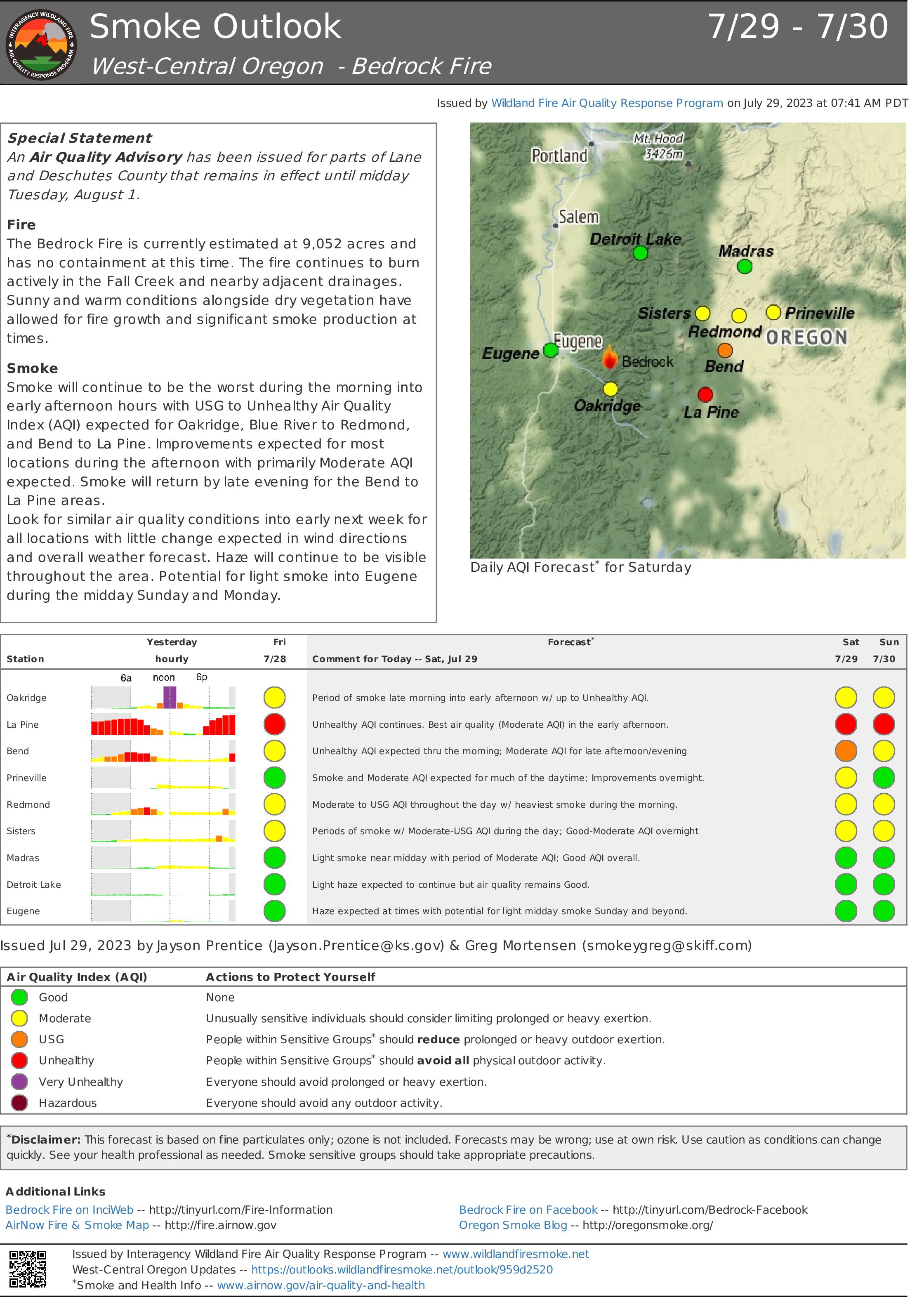
Smoke Outlook for July 29 July 30 2023
Related Incident: Bedrock Fire
Publication Type: News
Air Resource Advisors for the Bedrock Fire have issued a Smoke Outlook for July 29 - July 30, 2023. Please see the attached files.
Bowles Creek Fire Update for July 29 2023
Related Incident: Bowles Creek Fire
Publication Type: News
Bedrock Fire Update for July 29 2023
Related Incident: Bedrock Fire
Publication Type: News
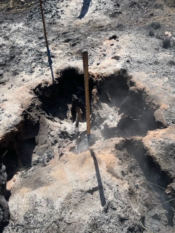
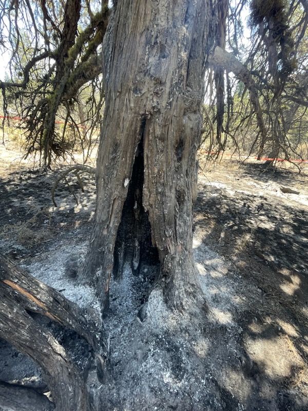
Lowell, Ore. – The Bedrock Fire continued to spread yesterday, with much of the growth in the Hehe and Andy creek drainages, and along Fall Creek toward the east. The fire progressed slower where there is less fuel, including in the 2021 Gales Fire perimeter. Similar growth and fire activity is expected today.
Additional personnel and equipment continue to arrive at the Bedrock Fire. These reinforcements, which include both engines and hand crews, have allowed fire managers to insert resources into areas east of the fire. Firefighters are identifying locations where fire lines can be established with both a likelihood of success and a low risk of serious injury to firefighters.
Firefighters are constructing fire line along ridges which offers a greater chance of stopping the fire while reducing risk and hazards. Ridgelines often have less vegetation and may have ground gentle enough for bulldozers and other heavy equipment. A line across the middle of a steep slope is much more likely to have fire push across it than one along a ridgeline. The hazards of falling trees and rolling or sliding logs are much greater when constructing a fire line across a steep slope, endangering personnel.
WEATHER: Saturday will be another sunny, dry day, with high temperatures around 80 degrees and relative humidity dropping to 30 to 35 percent. Similar weather conditions are expected into next week.
SAFETY: Willamette National Forest has issued a Forest Closure Order for the area around the Bedrock Fire. Please stay out of the closure area for your safety and the safety of fire personnel. Unmanned aerial systems (AES or drones) are not permitted within the Temporary Flight Restriction.
SMOKE: Smoke from the Bedrock Fire will continue to spread into central Oregon, causing some areas to experience “unhealthy” conditions. Individuals with respiratory issues may find themselves affected by the smoke.