
28 de Julio 2023 Informe Matutino para el Incendio Flat
Related Incident: Flat Fire
Publication Type: News
8 de Julio, 2023
Informe Matutino para el Incendio Flat
Extensión: 24,329
Inicio: 15-Julio-23
Origen: 2 millas Sureste de Agness, OR
Contencion: 10%
Causa: Error humano, bajo investigación
Personal: 1,643
Recursos: 51 camiones de bomberos l 38 escuadrillas de bomberos l 8 buldóceres l 33 cisternas l 8 máquinas masticadoras l 11 helicópteros
Situación Actual: Las actividades para la supresión del incendio, se están dando las 24 horas del día. Se han establecido completamente las líneas primarias de control en el lado Norte del fuego; las escuadrillas de bomberos continuaran con su tarea ardua de limpieza y patrullaje.
Los trabajadores se encuentran preparando líneas de contención para realizar operaciones de incendio hacia las afueras del lado Oeste y utilizando la carretera forestal (FR) 2308 (Burn Ridge) y FR 150. Los aviones cisterna y los helicópteros han estado aplicando retardantes de fuego para reforzar líneas de contención al Este de Game Lake. Se seguirá avanzando en las operaciones de incendio sobre la carretera FR 3318 (Wildhorse Ridge Road) y la carretera FR 3680.
Actividades diurnas: Los bomberos continúan evaluando las estructuras a lo largo de Lobster Creek y Wildhorse Ridge, tratando de identificar residencias aisladas en el lado Oeste del área cumbre en la montaña. Una vez completada esta tarea, las evaluaciones de las estructuras seguirán en pie en el corredor de Rogue River. Estas evaluaciones se realizan con el objetivo de ofrecer servicios de inteligencia si llegara a ser necesario. Si las condiciones lo permiten, se llevarán a cabo operaciones de incendio en los lados Suroeste, Sur y Noreste del incendio. Los bomberos trabajando a mano y los trabajadores utilizando maquinarias coordinaran la labor sobre las líneas alternativas de contención al lado Oeste y Noreste en donde el fuego está progresando.
Evacuaciones: Permanece en efecto el Nivel de Evacuación 1 “Listos” para las áreas en el lado Norte de Rogue River en Old Agness hacia Illahe Lodge y a lo largo del corredor de este rio desde el campamento de Quosatana Creek hasta el área de Agness. Incluyendo las zonas de Spud Road, Old House Creek Road y Oak Flat. El área Este, cercana a Agness permanece a un Nivel de Evacuación 2 debido al peligro extremado que el incendio representa. Ciertas áreas que se encuentran en las afueras de la zona quemada hacia el Suroeste permanecerán a un Nivel de Evacuación 2 mientras los bomberos continúen asegurando más las líneas de control. La Oficina del Alguacil para la ciudad de Curry continuara coordinándose con el Grupo para el Manejo de Incidente de Incendio y serán los responsables de notificar a los residentes afectados por el incendio acerca de las razones para cambiar los niveles de evacuación.La ciudad de Curry está enviando noticias de evacuación utilizando el sistema Everbridge. Usted puede registrarse en: https://www.co.curry.or.us/departments/emergency_management/index.php.
Condiciones climáticas: Se pronostican condiciones climáticas calientes y secas para los próximos días. Los vientos provendrán del Noreste hacia el Noroeste, con ráfagas de hasta 20 mph.
Impacto del humo: Pronósticos en la presencia del humo, puede encontrarse en la página web: https://outlooks.airfire.org/outlook/en/b74901f7
Cierres de áreas: El Bosque Nacional de Rogue River-Siskiyou, ha emitido una orden de cierre en el área del incendio la cual incluye senderos, carreteras y parte del rio Illinois. Esta orden de cierre abarca Oak Flat Campground, Game Lake Campground, Wildhorse Campground y el Lookout Recreacional de Snow Camp. Para mayor information: bit.ly/RRSNFClosures
Orden de restricción: Se han establecido Restricciones en el área. Para más información: fs.usda.gov/rogue-siskiyou
Si esta remolcando, por favor asegúrese que las cadenas no estén demasiadas sueltas. Arrastrando cadenas en el pavimento, podría producir chispas dando como resultado un incendio forestal.
Golden Fire Daily Morning Update July 28 2023
Related Incident: Golden Fire
Publication Type: News
Containment grows to 27% as crews focus on mop up and residents begin to return to homes.
Bonanza, OR – Firefighters continue mop-up operations as they achieve 27% containment and cool burnt areas 100 feet within the fire’s edge.
Today, firefighters will focus on expanding containment and working in unburnt areas, or “islands,” within the fire’s perimeter. Hand crews are securing those areas and cooling portions of the line that are still smoldering and burning.
Elsewhere, hand crews are using infrared sensors to find and extinguish hot spots along the fire’s outer edges. The National Weather Service has declared a Fire Weather Watch over the fire area due to low humidity and gusty winds. Officials urge residents to be mindful of their midday activities and follow fire precautions. Crews will continue to patrol the fireline regularly and remain alert and respond to any new fire activity.
Evacuation changes: The Klamath County Sheriff’s Office reduced evacuation levels for the Golden Fire to Level 2 (be ready) for all areas within the fire perimeter east of highway 140. All other evacuations were lifted. Incident officials urge residents to be cautious while driving around or within affected areas as firefighters and utility workers work in the area.
Additional updates can be found at: https://www.facebook.com/goldenfire2023/.
Weather: The fire area is currently under Red Flag and Fire Weather Watch conditions. Today’s weather will generate potential for active fire behavior. Wind and lowering relative humidity (RH) will produce critical fire weather over the fire area. High temps, low RH, and windy afternoon conditions will persist for the next several days. Winds will continue to increase in speed as over the next few days.
Evacuations: American Red Cross and Klamath County Community Emergency Response Team (CERT) have established an evacuation shelter at: Bonanza School, 31601 Mission Street, Bonanza, OR 97623. For the latest evacuation information call the Klamath County hotline (541) 205-9730. To sign up for Klamath County alerts, visit http://alerts.klamathcounty.org.
Recovery Contact Information: Information for services and resources for those impacted by the community with unmet needs, residential cleanup guidance, disaster social services and donations are available, see flyer attached.
Actualizacin del Incendio Lowline Viernes 28 de Julio 2023 900 am
Related Incident: Lowline Fire
Publication Type: News
Equipo de Gestión de Incidentes del Complejo del área de las Montañas Rocosas 1
Dan Dallas, Comandante del Incidente
Teléfono de Información: 970-648-4470 (publico), 970-765-7123 (medios de comunicación)
Correo electrónico: 2023.lowline@firenet.gov
Horario: 8 a.m. – 8 p.m.
Nota Especial: Esta mañana a las 6:00 am, el Equipo 1 de Manejo de Incidentes del Complejo de las Montañas Rocosas (CIM) asumió la responsabilidad del manejo del Incendio Lowline. El equipo es uno de los tres equipos de CIM en el área geográfica de las Montañas Rocosas. El equipo agradece a los medios terrestres y aéreos que han estado manejando el fuego hasta el momento. Su buen trabajo nos ha preparado para extinguir el fuego con éxito mientras protegemos hogares, otras estructuras, infraestructura y otros recursos. Al igual que con todos los incendios forestales, la seguridad pública y de los bomberos es nuestra máxima prioridad.
Las actualizaciones, fotos y videos del incendio Lowline se publicarán durante todo el día en Facebook en este enlace: www.facebook.com/GMUGFireInfo.
Situación Actual: El incendio Lowline mide 730 acres y está 0% contenido. Ayer, los equipos avanzaron en la creación de una línea de fuego a través de combustibles defendibles en el hábitat de salvia/pradera de césped antes del borde del fuego. Hoy, el plan es vincularse con esas líneas existentes y continuar moviéndose hacia el norte creando un cortafuego de combustible donde sea posible a través de la madera, integrando aeronaves para enfriar el borde del fuego, ralentizando la propagación y permitiendo que los bomberos y otro personal trabajen de manera segura en el suelo. El enfoque principal continúa siendo la protección de la estructura.
Condiciones del Clima y Combustibles: Hoy y el sábado es probable que haya lluvias y tormentas eléctricas por la tarde y por la noche, siendo las principales preocupaciones ráfagas de viento y relámpagos. Las posibilidades de lluvias húmedas probablemente se mantendrán por debajo del 20 % hasta el sábado y aumentarán del 40 al 60 % el domingo hasta la próxima semana.
Los combustibles principales en el área del incendio son coníferas mixtas con un componente pesado de muerte y caído, al igual que pasto y arbustos. La actividad del fuego se moderó ayer debido a la nubosidad de la mañana y la alta humedad relativa de la tarde. Sin embargo, el pronóstico de hoy es de menos nubosidad y menor humedad, con potencial para ráfagas de viento de hasta 20 mph esta tarde. Estas condiciones favorecerían el comportamiento activo del fuego, por lo que se prevé un aumento de la actividad del fuego esta tarde dentro de la madera, incluidos los flancos, el retroceso, las carreras cortas cuesta arriba con potencial para la quema de árboles individuales y grupales, y la detección de corto alcance.
Evacuaciones, Cierres, y Restricciones de Incendios: Se han realizado evacuaciones obligatorias en los drenajes de Squirrel Creek y Mill Creek. Para obtener información específica sobre evacuación, consulte Manejo de emergencias del condado de Gunnison en www.gunnisoncounty.org. Puede registrarse para recibir alertas de emergencia en sus teléfonos u otros dispositivos en: https://bit.ly/3QhZVZg.
El Sendero del sistema Forestal Nacional #438 - Lowline Trail está cerrado. El camino del condado 730 Ohio Pass Road está bloqueada desde Kebler Pass Road hasta el marcador de la milla 5 en Redden Ranch. Las actualizaciones del cierre se publicarán en la página de Facebook de información sobre incendios de GMUG en www.facebook.com/GMUGFireInfo. En interés de la seguridad pública, los bomberos piden a los visitantes que estén atentos al tráfico de incendios y que eviten el área.
Actualmente no hay restricciones de incendios en el condado de Gunnison. Si se implementan restricciones, se publicarán en este sitio: https://westslopefireinfo.com/gunnison-county/.
Los incendios forestales son una zona de exclusión aérea para aeronaves no autorizadas, incluidos los drones. Si tu vuelas, nosotros no podemos. Para obtener más información, visite http://knowbeforeyoufly.org.
Estadísticas del Incendio Lowline:
Tamaño: 730 acres
Contenido: 0%
Personal: 133
Locación: 14 mi. NNW de Gunnison, CO
Reportado: 8:00 am 26 de Julio, 2023
Causa: Relámpago
Para mas Informaccion:
Línea Telefónica : 970-648-4470 (public), 970-765-7123 (media)
Correo electrónico: 2023.lowline@firenet.gov
InciWeb: https://inciweb.wildfire.gov/incident-information/cogmf-lowline-fire
Facebook: www.facebook.com/GMUGFireInfo
Blum Fire Daily Update for July 28 2023
Related Incident: Blum Fire
Publication Type: News
July 28, 2023
8:30 am
Size: 300 acres
Containment: 40%
Date Started: July 26, 2023
Cause: Unknown
Structures: It was initially reported that five homes were destroyed by the Blum Fire in Hill County. After further assessment of the burned area, this was determined not to be true. No homes have been destroyed by the fire. One outbuilding, however, is confirmed to have been lost to the fire.
Evacuations: No evacuations are in effect.
The Blum Fire started on July 26, 2023, and was responded to by multiple fire departments initially. Texas A&M Forest Service was requested for assistance at 3:15 p.m. and responded with aviation resources, heavy equipment, and engines from Texas A&M Forest Service and Texas Intrastate Fire Mutual Aid System (TIFMAS). Multiple departments from Hill, Johnson, and Bosque counties are working in Unified command with Texas A&M Forest Service, and Texas Division of Emergency Management (TDEM).
Closures: FM Road 933 is now open. Please use caution when traveling along this roadway as fire crews are still working along this road to suppress the Blum Fire.
Yesterday: Aviation resources and heavy equipment were able to add additional containment lines and continue working on suppression of fire activity within the containment lines. Equipment crews and engines spent the night working to construct and improve containment lines around the perimeter of the fire and continue the process of mopping-up, putting out any areas of heat within the first 100 feet of the containment lines.
Today: Engine crews will be patrolling around the perimeter of the fire and the interior roads, working to suppress any active flames and smoking areas. Heavy equipment from Texas A&M Forest Service and Hill County are continuing to construct and improve the containment lines. As the day warms and dries, engines will continue to be ready in the event that the fire does jump outside of its containment lines. Additional resources will be coming back on scene later today in preparation for this afternoon. Aerial resources are standing by in case they are needed for suppression.
Weather and Fire Behavior: Moderate winds with higher gusts will continue today and through the weekend. High temperatures and low relative humidity, similar to yesterday’s conditions will continue for the next several days.
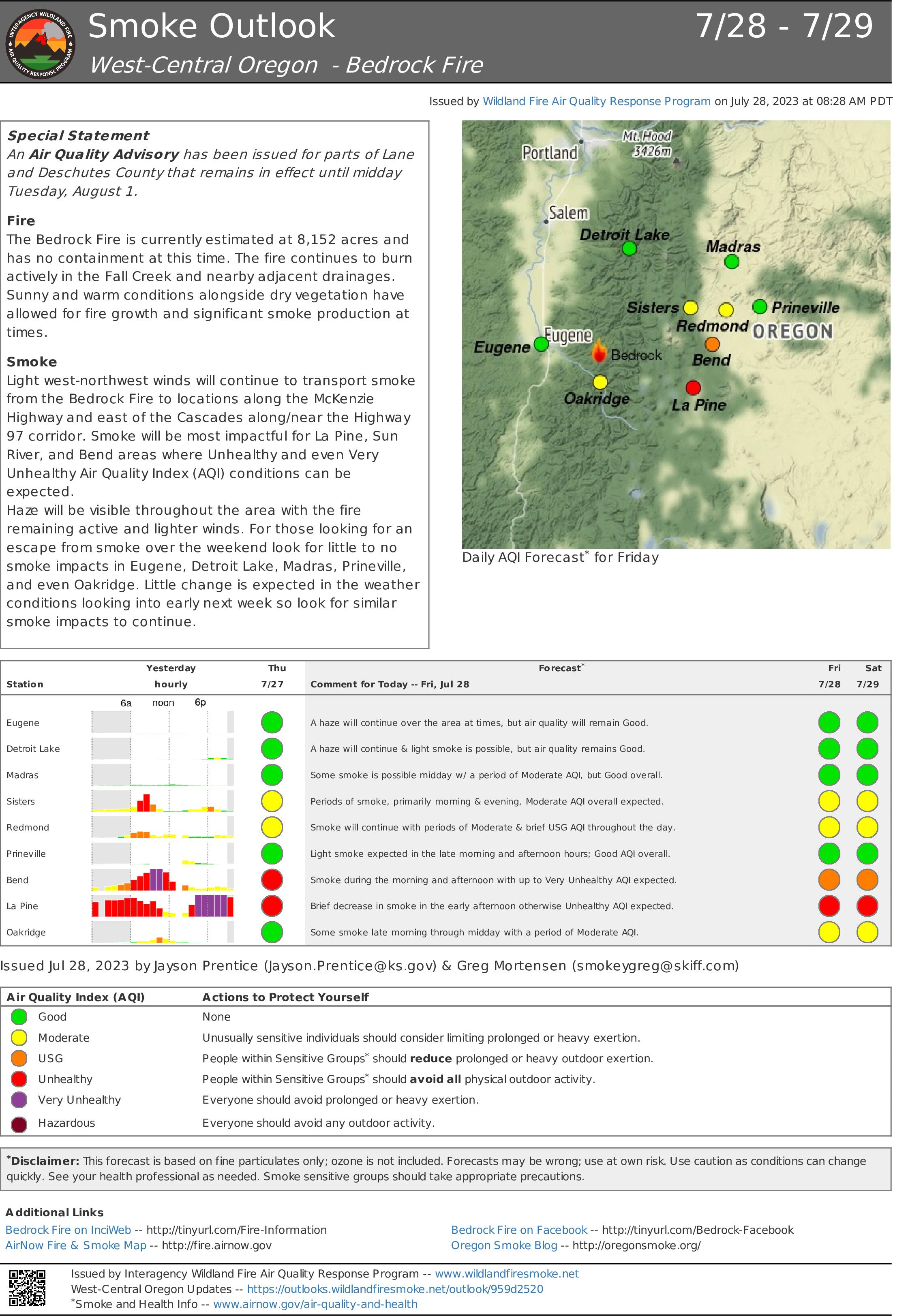
Smoke Outlook for July 28 July 29 2023
Related Incident: Bedrock Fire
Publication Type: News
Air Resource Advisors for the Bedrock Fire have issued a Smoke Outlook for July 28 - July 29, 2023. Please see the attached files.
Bedrock Fire update for July 28 2023
Related Incident: Bedrock Fire
Publication Type: News
Bedrock Fire update for Friday, July 28, 2023
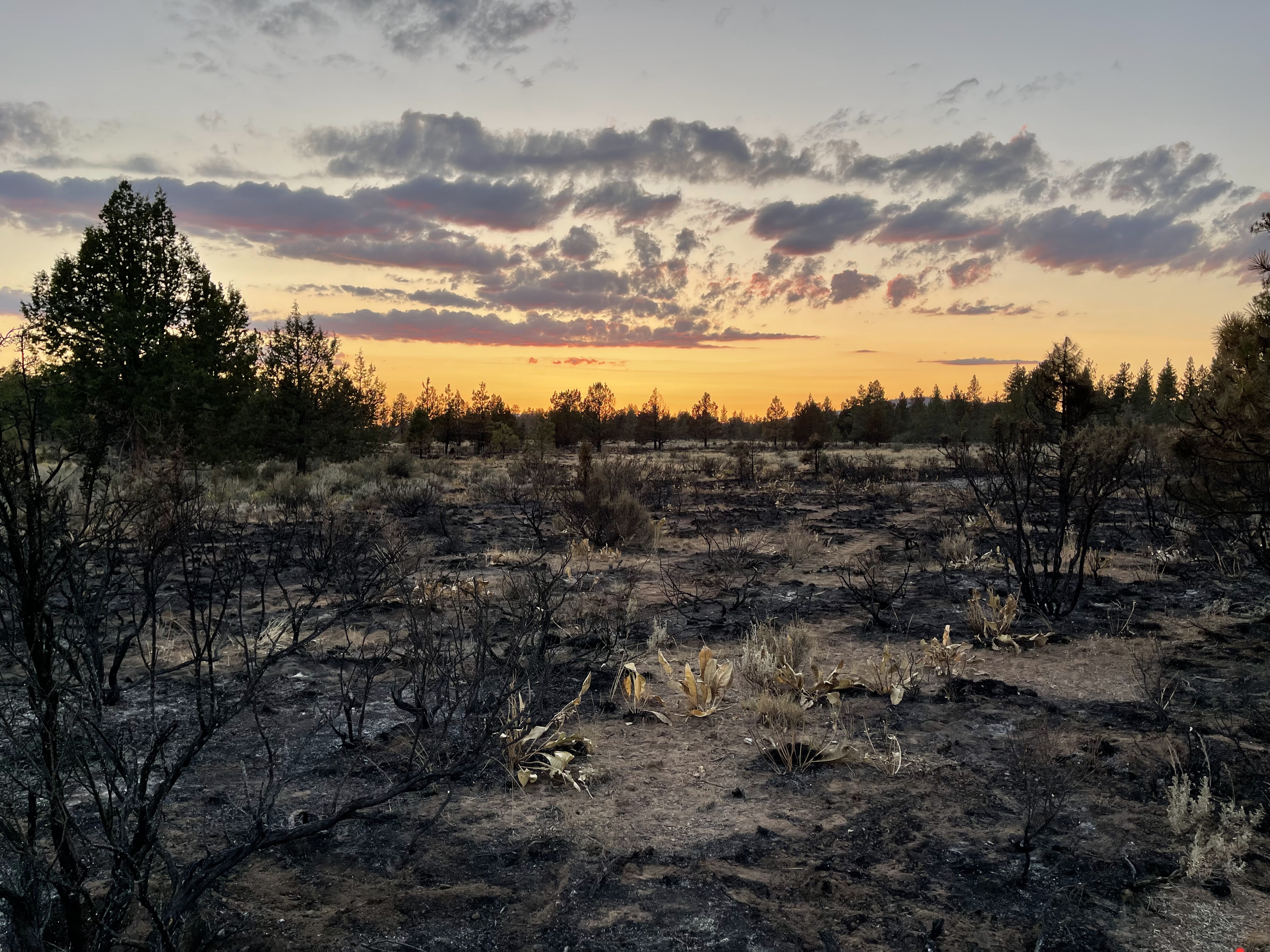
Lowell, Ore. – The Bedrock Fire continued to burn actively yesterday after the inversion lifted. Much of the growth was to the north in the Hehe Creek drainage and to the south near Andy Creek. Similar growth is expected today. Fire progression is largely driven by topography, with flames spreading uphill within steep drainages. Unusually dry fuels are contributing to the fire’s growth.
There has been no measurable precipitation in the Bedrock Fire vicinity since mid-May. Unusually hot weather has baked the moisture out of vegetation. As a result, the moisture content in both green vegetation and dead wood is much lower than normal for this time of year, closer to the levels usually found in late August.
These dry fuels ignite easily, burn intensely, and require a lot of water and effort to extinguish. In addition, embers carried by the wind have greater potential to land on fuels dry enough to ignite, creating spot fires. These spot fires may be as far as one mile ahead of the main fire, creating extra hazards for fire personnel working in the vicinity, which increases difficulty of providing containment.
Masticators are operating along roads and old fire lines cutting vegetation and creating fuel breaks. Fire crews are working to create fire lines in remote areas and on ground too steep for the heavy equipment
WEATHER: Friday’s temperatures are expected to reach the upper 70s, with relative humidity dropping to 35 percent. Weather conditions should be similar this weekend, with winds from the northwest and no chance of rain.
SAFETY: Willamette National Forest has issued a Forest Closure Order for the area around the Bedrock Fire. Please stay out of the closure area for your safety and the safety of fire personnel. Unmanned aerial systems (AES or drones) are not permitted within the Temporary Flight Restriction.
SMOKE: Smoke from the Bedrock Fire is spreading into central Oregon, causing some areas to experience “unhealthy” conditions. Individuals with respiratory issues may find themselves affected by the smoke. Smoke levels can change rapidly depending on weather.
Flat Fire Morning Update 7282023
Related Incident: Flat Fire
Publication Type: News
July 28, 2023
Flat Fire Morning Update
Size: 24,329
Start Date: July 15, 2023
Point of origin: 2 miles southeast of Agness, OR
Containment: 10%
Cause: Human caused, Under Investigation
Total personnel: 1,643
Resources: 51 engines l 38 crews l 8 bulldozers l 33 water tenders l 8 masticators l 11 helicopters
Current Situation: Fire suppression activities are taking place 24 hours a day on the Flat Fire. Primary control lines on the north side of the fire are well established; crews will continue to mop up and patrol. Out to the east, firefighters are preparing containment lines for firing operations using Forest Road (FR) 2308 (Burnt Ridge) and FR 150. Air tankers and helicopters have been applying retardant to reinforce containment lines east of Game Lake. Firing operations will continue down FR 3318 (Wildhorse Ridge Road) and FR 3680.
Today’s activities: Firefighters continue to assess structures along Lobster Creek and Wildhorse Ridge, identifying remote buildings on the west side of the ridge. Once that is completed, structure assessment will continue down the Rogue River corridor. Structure assessment is done to provide intelligence should there be a need. If conditions allow, firing operations will take place on the southwest, south, and northeast sides of the fire. Handcrew and machinery work on alternate containment lines on the west and northeast sides of the fire is progressing.
Evacuations: A Level 1 “Get Ready” evacuation notice is in effect for areas on the north side of the Rogue River in Agness up to Illahe Lodge and along the Rogue River Corridor from Quosatana Creek Campground to the Agness area. This includes the areas of Spud Road, Old House Creek Road and Oak Flat.
The area immediately east of Agness remains in a level 2, out of an abundance of caution. Some areas outside the burn area to the southwest will remain in Level 2 while fire crews continue to further secure control lines. The Curry County Sheriff’s Office will continue to coordinate with the Fire Incident Management Team and will notify all residents affected by the fire of any reasons to change evacuation levels. Curry County is using Everbridge to send evacuation notices. You can sign up for notifications here: https://www.co.curry.or.us/departments/emergency_management/index.php.
Weather: Weather conditions will likely remain warm and dry over the next few days. Winds are predicted from the northeast to northwest, with gusts up to 20 mph.
Smoke: The Smoke Outlook is available at: https://outlooks.airfire.org/outlook/en/b74901f7
Closures: The Rogue-River Siskiyou National Forest has issued a closure order for the fire area including trails, roads and a portion of the Illinois River. Oak Flat Campground, Game Lake Campground, Wild Horse Campground and Snow Camp Lookout Recreation Rentals are all closed as part of the area closure. More information can be found here: bit.ly/RRSNFClosures.
Restrictions: Fire Restrictions are in place, to learn more visit: fs.usda.gov/rogue-siskiyou
Ensure your tow chains do not have excess slack. Dragging tow chains on pavement can create sparks which can start wildland fires.
Fire Information:(541)216-4579 Media inquiries: (541)237-6369 Email: 2023.flat.or@firenet.gov
Bowles Creek Fire Update for July 28 2023
Related Incident: Bowles Creek Fire
Publication Type: News
Lowline FIre Morning Update July 28 2023
Related Incident: Lowline Fire
Publication Type: News
Lowline Fire Update
Friday, July 28, 2023 – 9:00 a.m.
Rocky Mountain Complex Incident Management Team 1
Dan Dallas, Incident Commander
Information Phone: 970-648-4470 (public), 970-765-7123 (media)
Email: 2023.lowline@firenet.gov
Information Staffing Hours: 8 a.m. to 8 p.m.
Special Notes: This morning at 6:00 am, Rocky Mountain Complex Incident Management (CIM) Team 1 assumed management responsibility for the Lowline Fire. The team is one of three CIM teams in the Rocky Mountain geographic area. The team thanks the ground and aerial resources who have been managing the fire to date. Their good work has set us up to successfully suppress the fire while protecting homes, other structures, infrastructure, and other resources. As with all wildland fires, public and firefighter safety is our highest priority.
Lowline Fire updates, photos, and videos will be posted throughout the day on Facebook at this link: www.facebook.com/GMUGFireInfo .
Current Situation: The Lowline Fire now stands at 730 acres and is 0% contained. Yesterday, crews made progress creating fire line through defendable fuels in sage/grass habitat in advance of the fire edge. Today, the plan is to tie into those existing lines and continue moving North creating a fuel break where possible through the timber, integrating aircraft to cool the fire edge, slowing spread and allowing firefighters and other personnel to work safely on the ground. The primary focus continues to be structure protection.
Weather & Fuel Conditions:
Afternoon and evening showers and thunderstorms are likely today and Saturday, with gusty outflow winds and lightning being the primary concerns. Chances for wetting rains will likely stay under 20% through Saturday, increasing to 40 to 60% Sunday into next week.
The primary fuels in the fire area are mixed conifer with a heavy dead and down component, as well as grass and shrubs. Fire activity was moderated yesterday due to cloud cover in the morning and high relative humidity in the afternoon. However, today’s forecast is for less cloud cover and lower humidity, with potential for gusty outflow winds up to 20 mph this afternoon. These conditions would favor active fire behavior, so increased fire activity is anticipated this afternoon within the timber including flanking, backing, short uphill runs with potential for single tree and group torching, and short-range spotting.
Evacuations, Closures, and Fire Restrictions:
Mandatory evacuations are in place in the Squirrel Creek and Mill Creek drainages. For specific evacuation information, see Gunnison County Emergency Management at www.gunnisoncounty.org. You may sign up to receive emergency alerts on your phones or other devices at: https://bit.ly/3QhZVZg .
National Forest System Trail #438 - Lowline Trail is closed. County Road 730 Ohio Pass road is barricaded from Kebler Pass road to mile marker 5 at Redden Ranch. Closure updates will be posted to the GMUG Fire Information Facebook page at www.facebook.com/GMUGFireInfo . In the interest of public safety, fire officials ask visitors to be aware of fire traffic and avoid the area.
There are currently no fire restrictions in Gunnison County. Should restrictions be implemented, they will be posted at this site: https://westslopefireinfo.com/gunnison-county/ .
Wildfires are a no-fly zone for unauthorized aircraft, including drones. If you fly, we can’t. For more information, visit http://knowbeforeyoufly.org.
Lowline Fire Statistics:
Size: 730 acres
Containment: 0%
Total Personnel: 133
Location: 14 mi. NNW of Gunnison, CO
Reported: 8:00 am July 26, 2023
Cause: LIghtning
For More Information:
InciWeb: https://inciweb.wildfire.gov/incident-information/cogmf-lowline-fire
Facebook: www.facebook.com/GMUGFireInfo
(Note: Set page size to legal if you print the attached PDF)