
Grapevine Fire Area Closure July 282023
Related Incident:
Publication Type: Closures
Order Number: # 03-09-05-23-04
![]()
U.S. Department of Agriculture, U.S. Forest Service
Prescott National Forest
Verde Ranger District
Area/Road Closure
PROHIBITIONS
Pursuant to 16 U.S.C. § 551 and 36 C.F.R. § 261.50 (a) and (b) the following are prohibited on the National Forest System (NFS) lands, and roads in the Verde Ranger District, Prescott National Forest, described below and shown on the attached map incorporated into this Order as Exhibit A (Described Area/Roads):
- Going into or being upon the Described Area. 36 C.F.R. § 261.53(e) and
- Being on the Described Roads. 36 CFR 261.54(e)
EXEMPTIONS
Pursuant to 36 C.F.R. § 261.50(e), the following persons are exempt from this Order:
- Private property owners and residents within the closure area.
- Any Federal, State, or Local Officer, or member of an organized rescue or firefighting resource in the performance of an official duty.
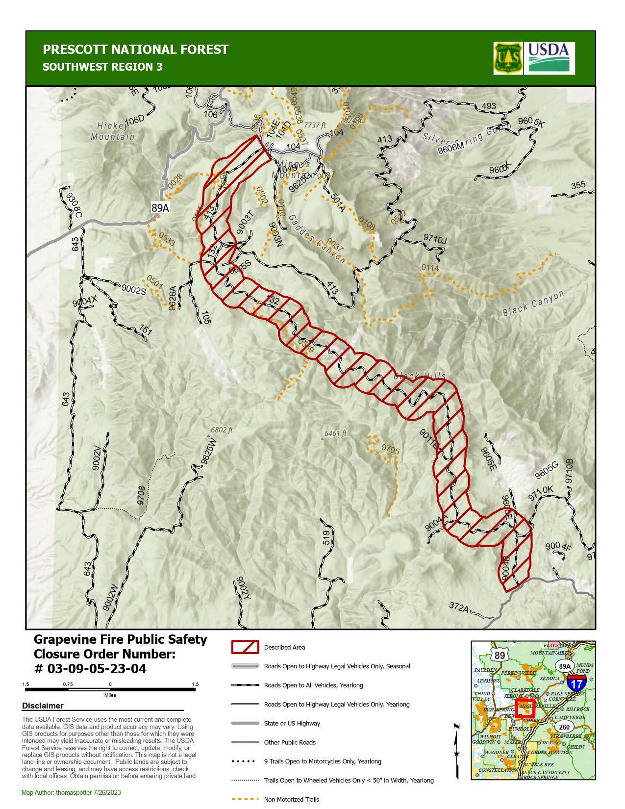
DESCRIBED AREA/ROADS
The following area closure is established within the specific areas of the Prescott National Forest, Verde Ranger District on all Forest Service lands as described below:
Along the route beginning at the junction of FR104 and FR413 and extending ¼ mile on either side of FR413 to junction of FR132 then along FR132 to the junction of County Rd 75, Cherry Creek Road.
PURPOSE
The purpose of this Order is to provide the public’s health and safety due to the Grapevine Fire on the Prescott National Forest.
IMPLEMENTATION
- This Order shall be in effect from July 27, 2023, at 0600 through August 30, 2023, at 2400, unless rescinded.
- A map identifying the Described Area/Roads is attached and made part of this Order as Exhibit A. For a digital version of this Order and Exhibit A, go to https://fs.usda.gov/alerts/prescott.
- Unless otherwise expressly defined in this Order, the terms used in this Order are defined by the regulations of the Secretary of Agriculture, 36 C.F.R. Chapter II, Parts 200-299. If there are terms in this Order that are not expressly defined in the Order or 36 C.F.R. Chapter II, Parts 200-299, their meaning shall be determined by their plain language definitions.
- A violation of the above prohibitions is punishable as a Class B misdemeanor by a fine of not more than $5,000 for individuals and $10,000 for organizations, or by imprisonment for not more than six months, or both. 16 U.S.C. § 551; 18 U.S.C. §§ 3559, 3571, and 3581.
- Contact the Verde Ranger District in Camp Verde, (928) 567-4121, and Prescott National Forest Supervisor’s Office in Chino Valley, (928) 777-2200, for more information about this Order.
- This Order supersedes any previous Orders prohibiting the same or similar acts on the same Described Area/Road.
Midnight Fire July 28 Update
Related Incident:
Publication Type: News
Midnight Fire
Nez Perce-Clearwater National Forest
Salmon River Ranger District
Fire Information Line - 208-935-6134
https://inciweb.nwcg.gov/incident-information/idncf-midnight-fire
July 28, 2023
Location: Forest Service Road (FSR) #284 (Elk City Wagon Road) 1 mile east of China Point, 3 miles Northwest of Pilot Knob near Mountain House Site
Start Date: 7/10/23 Cause: Lightning Size: 179 acres Completion/Containment: 25%
Total Personnel: 190 Engines: 2 Wildland Engines and 5 Tactical Water Tenders Dozers: 2 Forest Masticators: 2 Helicopters: 1 Retardant Tankers: As Needed Hand Crews: 4 on scene including 2 Interagency Hotshot Crews
CURRENT SITUATION
Heavy firefighting traffic is still expected to continue through the week on Forest Service Roads (FSR) #244, #284, and #1852 as resources continue to contribute to the suppression effort. Heavy equipment is being utilized to construct contingency line on FSR #1853 and #1855, and in Peasley Creek drainage area FSR #469 to #648. A fire camp is still established near McComas Meadows (Camp 58) to support the ongoing suppression efforts.
PLANNED ACTIONS
Direct attack, hand line and suppression efforts around perimeter of fire continues. Continued assessment of existing road and trail systems for heavy equipment use for construction of contingency line.
WEATHER AND FIRE BEHAVIOR
Sunny skies will prevail the next 48 hours. Winds will be slope/terrain driven in the late morning and afternoon hours. Expect moderate temperatures. Fire behavior is moderate with torching, group torching, and creeping. Fire growth has been minimal over the last few days but could change with weather conditions. Air quality information can be found at: AirNow Interactive Map (epa.gov)
CLOSURES AND SPECIAL MESSAGES
There are currently no closures in place, but firefighting traffic is expected to be heavy along FSR # 244 (Lighting Creek Road) and FSR# 284 (Elk City Wagon Road) between China Point and Lytle Cow Camp, while suppression operations are taking place. Fire Management Officials urge the traveling public to please avoid this area both on the ground and in the air. There is a Temporary Flight Restriction (TFR) in place over the Midnight Fire area for the safety of the aviation resources on scene.
Colt Fire Daily Update Friday July 28
Related Incident:
Publication Type: News
Colt Fire Fact Sheet
Montana Department of Natural Resources and Conservation Fire Protection
Lolo National Forest and Flathead National Forest Land Management
NORTHERN ROCKIES TEAM 1 INCIDENT COMMANDER: BRENT OLSON
Fire Information: 406-247-0922 2023.Colt@firenet.gov Facebook: https://www.facebook.com/ColtFire
https://inciweb.wildfire.gov/incident-information/mtmts-colt-fire
Friday, July 28, 2023 at 9:00 am
Location: 15 miles northwest of Seeley Lake, Montana
Start Date: 7/17/2023 Cause: Lightning Size: 5,252 acres Containment: 3%
Total Personnel: 538 Engines: 15 Helicopters: 5 Hand Crews: 12
KEY MESSAGE
A Temporary Flight Restriction (TFR) has been implemented over the fire area and the Condon airstrip has been closed for general aviation. This allows for firefighting aircraft to safely work over the fire area and the Condon airstrip is being used as a firefighting helicopter base. Pilots in the area should check these NOTAMs and follow all directions for both public and firefighter safety.
CURRENT STATUS
Yesterday, fire activity was observed as moderate while temperatures continued to trend a few degrees warmer and relative humidity levels dropping lower. The overnight infrared flight mapped the fire at approximately 5,252 acres in size, increasing by 315 acres.
Yesterday, on the east side of the fire along Forest Road 646 (Colt/Uhler Road) burning operations progressed well. The intent of this operation is to further secure the road’s use as a primary fire control line. Crews continued working to secure the spot fires in the area that ignited east of Forest Road 646 earlier in the week. On the fire’s north side, a Heavy Equipment Task Force and hand crews continued work reducing vegetation along Forest Road 906 (Beaver Creek Road) in preparation for burning operations. Personnel also searched the west flank for opportunities to construct fire line in locations that have a high probability of success to contain the fire. On the south side, crews worked directly on the fire edge, anchoring from constructed dozer and hand lines. Additionally in this area, two spot fires were discovered and secured. South Structure Protection worked on structure assessments on the east side of Lake Inez. North Structure Protection engines assisted in operations along Forest Road 646 (Colt/Uhler Road). Helicopter bucket water drops were effectively used to cool hots spots as needed.
PLANNED ACTIONS
Crews will continue burning operations along Forest Road 646 (Colt/Uhler Road) to secure the north and east flanks of the fire. On the south side, crews will continue to secure the spot fires, construct direct hand line towards the west, and assess road systems for potential control features near the West Fork of the Clearwater River. A Heavy Equipment Task Force and crews will continue working on vegetation removal and control line preparation along the Beaver Creek Road on the north side of the fire. South Structure Protection will continue structure assessments and protection work at Lake Inez. A night shift of engines and personnel will patrol and monitor fire conditions. Helicopters will be used to drop water on the fire as needed and where they can be most effective.
WEATHER AND FIRE BEHAVIOR
The high temperatures in the fire area on Friday will range from 71-81 degrees, with relative humidity levels 20-30%. Winds will be from the south at 5-9 mph with gusts up to 12 mph. There is a 20% chance of thunderstorms over the area and thunderstorm outflow winds could potentially gust to 25-30 mph. Fire behavior is expected to be low to moderate and with the active fire edge moving through the heavy dead and down surface vegetation. Torching and spotting are possible in the subalpine fir and lodgepole pine.
EVACUATIONS AND CLOSURES
The Missoula County Sheriff’s Office Evacuation Warning and Order summary:
-Residents on Beaver Creek Road (near the summit) are under an Evacuation Warning.
-Mile marker 31 (Beaver Creek Road at the intersection of Hwy 83) south towards Seeley Lake to mile marker 27, and including residences in Rovero Flats, are under an Evacuation Order.
-Residences beginning at mile marker 27, south end of Rovero Flats, to mile marker 25.5 (the intersection of the West Fork of the Clearwater Road and Hwy 83) are under an Evacuation Warning.
-Residences on the north and south ends of Lake Inez are under an Evacuation Warning. The east side of Lake Inez, along Hwy 83, is not under any Warning or Order.
If conditions rapidly change an Evacuation Order may be issued with no prior notice or warning. Home and property owners in the surrounding area should remain vigilant and prepared. Have an evacuation plan for family, pets, and livestock; sign up for emergency alerts at Smart911.com; and be familiar with the Missoula County evacuation process and what an order and warning means by clicking on the following link: https://www.missoulacounty.us/government/public-safety/office-of-emergency-management/evacuation-information. For evolving Evacuations and Warnings please visit the Missoula County Sheriff’s Office Facebook page at https://www.facebook.com/MissoulaCountySheriffsOffice .
The Lolo and Flathead National Forests have closed several forest roads, areas, and campgrounds near the fire area for public safety. The list of current closures includes:
-Forest Road 906 (closed at Highway 83)
-Rainy Lake Campground access road 4357 (closed at Highway 83)
-Rainy Lake Campground
-Alva Lake Campground access road (closed by gate at Highway 83)
-Alva Lake Campground
-Lakeside Campground access road (closed by gate at Highway 83)
-Lakeside Campground
-Lake Inez Campground
-Forest Road 646 (closed at the junction of FSR 552; FSR 4354; Forest Road 552 (beyond the turn off to west side Lake Inez access
-Forest Road 5407 and 463 closed beyond the West Side snowmobile trailhead (these roads access the Montana Fish, Wildlife, and Parks Marshall Wildlife Management Area and Lake Marshall)
-Temporarily closing the Forest System Road loops of the Clearwater (FSR 4370 and 4353) and Richmond (FSR 667 and 720)
TEMPORARY FLIGHT RESTRICTIONS
A Temporary Flight Restriction is in place for air space over the Colt Fire (FDC 03/0291) to provide a safe environment for firefighting aircraft operating in the area. An airport closure is in place for the Condon Airstrip (FDC 07/110) for firefighting helicopter operations. Remember that temporary flight restrictions also apply to unmanned aircraft systems (UAS) or drones. If you fly, we can’t!
July 28 2023 Daily Update
Related Incident:
Publication Type: News
NORTHERN ROCKIES TYPE 3 TEAM
INCIDENT COMMANDER: DAN BROWN
Consalus Fire
Priest Lake Ranger District, Idaho Panhandle National Forests
Fire Information 208-996-0980 | 2023.consalus@firenet.gov
https://tinyurl.com/consalusfire
July 28, 2023
Location: 10 miles west of Coolin, ID, in Pend Oreille County, WA
Start Date: 6/30/2023
Cause: Lightning
Size: 475 acres
Containment: 50%
Total Personnel: 190
Equipment: 1 Dozers, 2 Masticators, Excavator
Hand Crews: 3 + a district module
Engines: 1
Aircraft: 1 helicopter
Other: 2 Faller Modules, 5 Water Tenders, Ambulance, 2 REMs
The Consalus fire has not had any significant growth in over a week and remains at 475 acres and 50% contained. Firefighters continue to use sprinklers to cool the fires edge on the east and southeast perimeters, especially in the Consalus Creek area. The western side of the fire is being patrolled and monitored throughout the day by fire crews while they remove and backhaul unneeded equipment from the area.
Heavy equipment is working to clear and repair the roads that were affected by the fire and/or utilized by fire operations. These repairs are part of the suppression repair plan of which the intent is to minimize soil erosion, restore impacted ecological functions to their previous conditions, and repair trail and road systems to their original condition.
We ask the public to please recreate responsibly this weekend, and always. The public plays a valuable role in wildfire prevention. On average, 87% of all wildfires are caused by humans each year. Many of these wildfires occur near roads, communities, and recreation areas, threatening public safety. One Less Spark – One Less Wildfire
WEATHER AND FIRE BEHAVIOR
Warm and dry conditions will continue into Saturday with light terrain driven winds. A week cold front is expected to push across the fire area on Sunday. A slight potential for isolated dry lightning will be possible ahead of the front Friday night through Sunday. Today's max temperature is 88 degrees, with a minimum humidity of 21 percent. Winds are forecasted out of the north-northwest 4 to 6 mph.
CLOSURES AND SPECIAL MESSAGES
The Idaho Panhandle National Forests issued an emergency closure (Closure Order # 01-04-08-23-003) effective July 18, 2023. This replaced Closure Order #01-04-08-23-002. The emergency closure has been issued for public safety and prohibits all forms of travel on: Forest Service Road (FSR) #1108 from the junction with FSR #333 to the junction with FSR #659; FSR #1094 will remain open for the first 4.5 miles from the junction with FSR #312, but the remainder of FSR #1094 will be closed to the junction with FSR #1108. Additional road closures now include FSR #659 from the junction with FSR #312 to the junction with FSR #659B; FSR #333 from the junction with FSR #2730 to its terminus.
For firefighter and public safety, please avoid the following roads if possible: The remaining portion of FSR #1094 not part of the closure order; FSR #312 from the junction with FSR #333 to the junction with FSR #659; and FSR #333 from Highway 57 to the junction with FSR #1108. Please refer to the incident PIO map for a visual explanation.
We will still be using aircraft as needed therefore, for the safety of our aerial resources and firefighters on the ground, please do not fly unmanned aircraft (drones) in the fire vicinity. If you fly, we can't.
Grapevine Daily Update July 28 2023
Related Incident:
Publication Type: News
Grapevine Fire
July 28, 2023 – Daily Update
Fire Crews Continue to Protect Properties as Residents Return
Location: Mingus Mountain, Verde Ranger District (T14N, R2E, SEC 4), Approximately 10 miles east of Prescott Valley; 2 miles south of Mingus Spring Ranch
Start Date: July 21, 2023
Size: Approximately 1049 acres
Percent Contained: 0%
Cause: Lightning
Vegetation: Brush, Timber and Short Grass
Resources: 3 Type 1 Crews, 5 Type 2 Crews, 16 Engines, 2 Dozers, 4 Helicopters and additional support personnel
Number of Personnel Assigned: 359
Update: Fire crews will be continuing the process of monitoring the western side of the fire while holding and improving existing control lines with fire equipment, including dozers and helicopters, to protect the repopulated communities. Construction of barrier lines between the fire and properties will be constructed utilizing ground crew resources and heavy equipment. Crews will be conducting assessments on the eastern side of the fire for potential control line construction. Due to terrain and limited access; firefighters continue to identify hazards as they begin to safely suppress the fire.
Even without visible smoke there exists a potential of fire activity due to the heavy unburned fuels inside the interior of the Grapevine Fire. Flames could be pushed outside of the interior by drying conditions and monsoon winds.
Smoke: Smoke may be visible from multiple locations including Prescott Valley, Dewey, Prescott and along Highway 169.
Closures: Prescott National Forest Roads along the route beginning at the junction of FR104 and FR143 and extending ¼ mile on either side of FR413 to junction of FR132 then along FR132 to the junction of County Rd 75, Cherry Creek Road.
Fire Restrictions: The entire Prescott National Forest is under Stage 1 Fire Restrictions which prohibits building, maintaining, attending, or using a fire, campfire, or stove fire, including charcoal and briquettes, outside a structure that is provided by the Forest Service within designated areas for portions of the forest. Under these restrictions, discharging a firearm, air rifle or gas gun, except for persons engaged in legal hunting activities, is prohibited on the Prescott National Forest. Fireworks and the use of exploding targets are always prohibited year-round on national forests.
Yesterday, a repopulation of the Whitehorse community was conducted by the Yavapai County Sheriff’s Office due to the reduced threat of fire burning towards the area. Residents will remain in SET Status.
For current evacuation information contact the Yavapai County Sheriff’s Office at 928-771-3260 or follow them at https://www.facebook.com/YavapaiCountySheriff.
Recreationists on Mingus Mountain should avoid camping and hiking near the fire and utilize caution while driving the roads as firefighters will be traveling to and from the fire.
For fire information please call (928) 925-1111; or stay up to date on Prescott National Forest news by checking the Prescott NF website and following us on Facebook and Twitter.
Racetrack Fire Update July 28 2023
Related Incident: 2023 Racetrack Fire
Publication Type: News
Racetrack Fire Update - July 28, 2023
The next Racetrack Update will be on Sunday, July 30, 2023
Location: North of Highway 169, south of Crater Mountain near the community of Cherry
Start Date: July 23, 2023
Size: 405 acres
Cause: Lightning
Containment: 60%
Resources: 1 Type-1 Crew, 2 Type-2 Crews, 4 Engines, 1 Dozer and additional support personnel.
Fire behavior: Low fire behavior
Types of vegetation in the area (aka fuels): Grass, Brush
SUMMARY: Southwest Area Type 4 Team led by Incident Commander Andrew Giralt, assumed command of the Racetrack fire this morning, Friday July 28, 2023. Firefighters have made progress strengthening and improving the perimeter of the Racetrack Fire, preventing growth during afternoon thunderstorms. Crews and heavy equipment will continue to patrol the fire, mop up remaining hot spots near control lines, repair and rehabilitate areas where suppression actions were taken, and clear hazardous snags and debris. in and around the fire area. Light smoke may be visible at times, as interior fuels continue to burn and smolder.
Over the next few days, the Incident Management Team will begin to release resources. This process is known as right-sizing the organization. Crews will be released from the fire as objectives are met and made available to assist with other wildfires in the southwest. Remaining resources will patrol and hold the fire perimeter to ensure the fire remains within the planning area.
Today monsoon moisture is expected to start increasing in the region. This will result in greater coverage of showers and storms in the area.
Evacuations – Please follow Yavapai County Sheriff’s Office Facebook page for current evacuation information at: https://www.facebook.com/YavapaiCountySheriff or call their non-emergency number at 928-771-3260.
FIRE RESTRICTIONS: The entire Prescott National Forest is under Stage 1 Fire Restrictions which prohibits building, maintaining, attending, or using a fire, campfire, or stove fire, including charcoal and briquettes, outside a structure that is provided by the Forest Service within designated areas for portions of the forest. Under these restrictions, discharging a firearm, air rifle or gas gun, except for persons engaged in legal hunting activities, is prohibited on the Prescott National Forest. Fireworks and the use of exploding targets are always prohibited year-round on national forests.
For fire information please call (928) 925-1111.
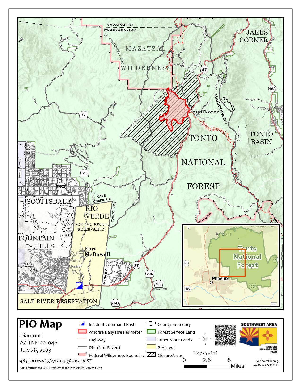
Diamond Fire Tonto Daily Update 07282023
Related Incident:
Publication Type: News
Location: Southwest of Sunflower Start Date: 07/22/2023 Cause: Under investigation
Size: 4,635 acres Containment: 0% Total Personnel: 344
Resources Successful in Holding Diamond Fire After Thunderstorm Activity
OPERATIONAL UPDATE
Yesterday was largely a calm day regarding fire activity on the Diamond Fire. The bulk of activity occurred on the northern portion of the fire where resources managed a slop over and a few spot fires in the Alder Creek drainage as the result of thunderstorm activity from the previous night. However, groundcrews were successful in securing these areas of concern. Additionally, managers began staffing some areas that are difficult to access on the northwest and west portions of the fire. There was minimal fire progression on the east to southeast portions of the fire and crews employed aircraft late in the shift to boost overnight humidities along the fire’s edge.
For today’s operational shift, ground resources will utilize aerial resources to continue holding the fire around the community of Sunflower, as well as along Hwy 87. Crews on the southern and southeastern section of the fire will monitor fire behavior and continue with fuel removal along the 1333 road for potential future use as a holding feature. Additional resources will be mobilized to the western area of the fire, with a Type 1 helicopter assisting to keep the fire in place.
Although not planned at this time, there is the possibility there will be a need to close State Road 87. If you plan on traveling in the area, pay close attention to https://az511.gov/ and our Facebook page for the most up to date road closure information.
WEATHER AND FIRE BEHAVIOR
Temperatures are expected to remain in the triple digits today with relative humidities remaining below 20 percent. Winds will generally be less than 20 miles per hour out of the west in the morning with a shift to a more northerly direction in the late afternoon and evening. An increase in thunderstorm activity can be expected in the afternoon with an increase in monsoonal convection progressing northward. These afternoon thunderstorms may bring stronger and erratic outflow winds. Where winds align with steep topography and vegetation, fire activity is expected to increase with the possibility for rapid growth.
CLOSURES AND SPECIAL MESSAGES
The National Forest has issued a closure order for the fire area to provide public health and safety due to firefighting operations and fire danger associated with the Diamond Fire. Forest Road 627, west of State Route 87, remains closed to the general public per the Forest Area Closure.
Lastly, there was a recent drone intrusion within the Diamond Fire temporary flight restriction area. The Diamond Fire would like to remind people that there is a temporary flight restriction over the fire area, which includes the use of drones (UAS). Flying a drone over a fire area is dangerous to pilots and will cause air operations to shut down. Flying a drone within the restricted area is illegal.
Hayden Fire Update July 28 2023
Related Incident:
Publication Type: News
Acres: 14, 745
Containment: 0%
Personnel: 689
Summary: The Hayden Fire started on Wednesday, July 19th, 2023, at approximately 11:30 am. The fire is located in the Lemhi Range, 18 miles west of Leadore, Idaho. The fire is burning in steep and difficult terrain with spruce/subalpine fir containing a heavy dead/down timber component. Fire cause is undetermined. The Hayden Fire is a full suppression fire. Firefighters are working long hours every day working to contain the fire as quickly as they can, impacting the fewest acres possible.
Weather: THERE IS A RED FLAG WARNING FOR GUSTY WINDS & LOW RELATIVE HUMIDITY. Southwesterly winds with gusts up to 20 miles per hour will persist over the fire today. Combined with low relative humidity, critical fire weather conditions are once again predicted.
Actions: Crews on the northern flank continue to improve the primary containment line by conducting burnout operations in the evening into the nighttime hours due to more favorable conditions. Personnel on the east flank of the fire have been working diligently to ensure both primary and alternate containment lines which are a mix of dozer line and hand constructed line are completely reinforced. Aviation played a significant role in supporting the operations being conducted on the north and east flanks of the Hayden Fire as visibility has improved.
Important Information: The Lemhi County Sheriff’s Department in coordination with the Salmon‐Challis National Forest and Great Basin Team 7 has pre‐identified evacuation zones. They will be implemented using the “Ready, Set, Go” terminology, for more information on the evacuation zones please visit the Lemhi County website at lemhicountyidaho.org. Information on “ready, set, go” is available on the Hayden Fire Inciweb page.
The U.S. Forest Service, Idaho Department of Lands, and Bureau of Land Management in east‐central Idaho began Stage 1 fire restrictions, just after midnight (12:01 am) this morning. For more information, please visit the Salmon‐Challis National Forest’s webpage listed in the “online links” section.
The Salmon‐Challis National Forest has a revised closure order in place to help protect firefighter and public safety. Maps and additional information are available on the Alerts and Notices section of the SCNF website. Risk to responders and public safety remains the highest priority for the incident management team.
27 de Julio 2023 Informe vespertino del Incendio Flat
Related Incident: Flat Fire
Publication Type: News
27 de Julio, 2023
Informe vespertino del Incendio Flat
Extensión: 23,678
Inicio: 15-Julio-23
Origen: 2 millas al Sureste de Agness, OR
Contención: 10%
Causa: Error humano, bajo investigación
Personal: 1,644
Recursos: 50 camiones de bomberos l 38 escuadrillas de bomberos l 8 buldóceres l 34 cisternas l 8 máquinas masticadoras l 11 helicópteros
Situación actual: Los recursos aéreos ayudaron en el reforzamiento de las características avanzadas de control a lo largo del perímetro Sureste lanzando retardantes de incendio en el área al Este de Game Lake. También los helicópteros irrigaron el perímetro Sureste con el objetivo de lograr moderar el comportamiento del incendio y detener un poco su progresión hacia el Este. Los bomberos aprovecharon las condiciones favorables del clima y utilizaron operaciones de incendio para asegurar líneas adicionales de control a lo largo de la carretera forestal (FR) 3680 dirigida hacia el área de Snow Camp. Cuatro bomberos aéreos fueron desplegados sobre un espacio pequeño que se encuentra en llamas y el cual todavía muestra una mínima actividad en las afueras del eje Sureste del centro del incendio.
Actividades para la noche de hoy: Los bomberos aéreos iniciaran la supresión y la limpieza del área quemándose directamente en el eje del incendio. Si las condiciones climáticas lo permiten, los bomberos continuaran con las operaciones de quema a lo largo de la carretera forestal (FR) 3680 moviéndose hacia el camino forestal FR 402. Los recursos de ayuda también limpiaran el área que fue previamente quemada extinguiendo espacios de emanación de calor más profundos y desde las líneas de control a través del incendio.
Evacuaciones: Permanece en efecto el Nivel de Evacuación 1 “Listos” para las áreas en el lado Norte de Rogue River en Old Agness hacia Illahe Lodge y a lo largo del corredor de este rio desde el campamento de Quosatana Creek hasta el área de Agness. Incluyendo las zonas de Spud Road, Old House Creek Road y Oak Flat. El área Este de Agness permanece a un Nivel de Evacuación 2 debido al peligro extremado que este representa. Ciertas áreas que se encuentran en las afueras de la zona quemada hacia el Suroeste permanecerán a un Nivel de Evacuación 2 mientras los bomberos continúen asegurando más las líneas de control. La Oficina del Alguacil para la ciudad de Curry continuara coordinándose con el Grupo para el Manejo de Incidente de Incendio y serán los responsables de notificar a los residentes afectados por el incendio acerca de las razones para cambiar los niveles de evacuación. La ciudad de Curry está enviando noticias de evacuación utilizando el sistema Everbridge. Usted puede registrarse en:https://www.co.curry.or.us/departments/emergency_management/index.php
Condiciones climáticas: Se pronostican condiciones climáticas calientes y secas en los próximos días. Los vientos provendrán del Noreste hacia el Noroeste, con ráfagas de hasta 20 mph.
Impacto del humo: Pronósticos en la presencia del humo, puede encontrarse en la página web:
https://outlooks.airfire.org/outlook/en/b74901f7
Cierres de áreas: El Bosque Nacional de Rogue River-Siskiyou, ha emitido una orden de cierre en el área del incendio la cual incluye senderos, carreteras y parte del rio Illinois. Esta orden de cierre abarca Oak Flat Campground, Game Lake Campground, Wildhorse Campground y el Lookout Recreacional de Snow Camp. Para mayor information: bit.ly/RRSNFClosures
Orden de restricción: Se han establecido Restricciones en el área. Para más informacion:
Las fogatas están permitidas únicamente en campamentos designados y dichos campamentos tienen que proveer una base de metal que rodee el fuego. Por favor asegúrese de que su fogata este completamente apagada antes de salir del campamento.
Fire Information:(541)216-4579 Media inquiries: (541)237-6369 Email: 2023.flat.or@firenet.gov