
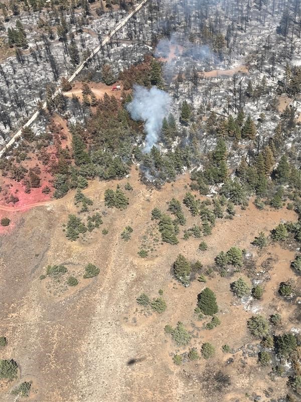
Fire crews suppressing Noonday Fire on Gila National Forest
Related Incident:
Publication Type: News
MIMBRES, NM, July 26, 2023 – Fire managers on the Wilderness Ranger District of the Gila National Forest are working a new lightning-caused fire called the Noonday Fire. The fire was reported in the evening July 22 very near the boundary between the Silver City and Wilderness Ranger District. It is approximately 366 acres and 0% contained.
The fire is situated within the 2013 Silver Fire area, on difficult terrain. Due to the location and terrain, the strategy will be to confine the fire to a pre-determined area and provide protection around structures and range infrastructure.
Resources assigned to the incident include one crew, one engine, and a hot shot crew expected later today, for a total of about 50 personnel. Crews will be assessing and reinforcing the Rabb Park trail today as the primary containment feature to keep the fire from progressing to the west toward the Mimbres Valley.
The fire weather forecast is showing the temperature in the high 90s with thunderstorms likely. Smoke is highly visible from the entire Mimbres Valley and Silver City area. Please check www.airnow.gov for air quality information.
For more information please visit the Gila National Forest at www.fs.usda.gov/gila and Facebook https://www.facebook.com/GilaNForest.
27 de Julio 2023 Reporte matutino del Incendio Flat
Related Incident: Flat Fire
Publication Type: News
27 de Julio, 2023
Reporte matutino del Incendio Flat
Extension: 23,678
Inicio: 15-Julio-23
Origen: 2 millas al Sureste de Agness, OR
Contención: 4%
Causa: Error humano, bajo investigación
Personal: 1,644
Recursos: 50 camiones de bomberos l 38 escuadrillas de bomberos l 8 buldóceres l 34 cisternas l 8 máquinas masticadoras l 11 helicópteros
Situación Actual: Los recursos continúan avanzando positivamente en la lucha para extinguir el incendio. Los bomberos han estado incendiando el flanco suroeste, con el objetivo de prevenir que el fuego aumente de tamaño hacia el lado Sur. En algunas áreas, los bomberos han tenido que hacer una pausa en los planes de operaciones de quema para asegurar la dirección ventajosa del viento. Los trabajadores continúan limpiando y trabajando en líneas alternativas en el área Noreste del fuego. En las zonas Oeste y Noreste, también se sigue trabajando tenazmente en las líneas alternativas. Los bomberos encargados de proteger la infraestructura han estado evaluando los edificios situados a lo largo de los ríos Illinois y Rogue River, así como también a lo largo de Cougar Lane.
Actividades para el día de hoy: El día de hoy se continuará con el trabajo exitoso que fue realizado el día de ayer. En el área Suroeste, se planean llevar a cabo operaciones de Incendio. Se estará trabajando al Sur de la carretera forestal (FR) 3318 y al Oeste de Game Lake. Se hará uso de los helicópteros y del sistema Aéreo sin personal (UAS) para profundizarse más en dichas operaciones. Dicha acción, da como resultado un almacenamiento intermedio entre las líneas de control y el área central del fuego. En la sección Noreste, los bomberos se encuentran preparando líneas de fuego en el terreno para las operaciones incendiarias que potencialmente se llevaran a cabo el viernes. Las líneas de control para el área Noreste han estado siendo limpiadas y patrulladas. Los bomberos continuaran trabajando en las líneas alternativas en las zonas Oeste y Noreste. Por el momento, contamos con una cantidad significativa de recursos aéreos disponibles para asistir a nuestros bomberos en cualquier momento.
Evacuaciones: El 26 de Julio, 2023, se logró reducir el Nivel 2 de Evacuación “Listos”, a lo largo del Corredor de Rogue River que se extiende desde el campamento de Quosatana Creek hasta el área de Agness, a un Nivel de Evacuación 1 “Prepárese”. Este Nivel de Evacuación 1 incluye las áreas de Spud Road, Old House Creek Road y Oak Flat. Se estará emitiendo un Nivel de Evacuación 1 para las áreas del lado Norte de Rogue River en Old Agness hasta Illahe Lodge.
El área inmediata al Este de Agness mantendrá un Nivel de Evacuación 2, especialmente para futuras operaciones de incendios. Algunas áreas que se encuentran fuera de la zona quemada en el Suroeste permanecerán a un Nivel de Evacuación 2, mientras los bomberos continúen trabajando en esa área asegurando más las líneas de control. La oficina del Alguacil para la ciudad de Curry en coordinación con el
Grupo de Manejo de Incidente de Incendios, serán los responsables de notificar a los residentes afectados por el incendio acerca de las razones por las cuales se hacen cambios en los niveles de evacuación.
La ciudad de Curry está enviando noticias de evacuación utilizando el sistema Everbridge. Usted puede registrarse en: https://www.co.curry.or.us/departments/emergency_management/index.php
Condiciones climáticas: Se pronostican temperaturas entre los 80 grados para el área de Agness. Se pronostican temperaturas entre los 70 grados en las áreas montañosas y en las partes más elevadas de las mismas. El porcentaje de la humedad relativa se ha pronosticado dentro de un 30-45% sobre las áreas menos elevadas y oscilando entre 40-55% en mayor altitud.
Se pronostican vientos provenientes del Noreste por la mañana y cambiando hacia el Noroeste en horas de la tarde, presentándose entre 8 – 13 mph con ráfagas alcanzando las 19 mph.
Impacto del humo: Pronósticos en la presencia del humo, puede encontrarse en la página web: https://outlooks.airfire.org/outlook/en/b74901f7
Cierres de áreas: El Bosque Nacional de Rogue River-Siskiyou, ha emitido una orden de cierre en el área del incendio la cual incluye senderos, carreteras y parte del rio Illinois. Esta orden de cierre abarca Oak Flat Campground, Game Lake Campground, Wildhorse Campground y el Lookout Recreacional de Snow Camp. Para mayor informacion: bit.ly/RRSNFClosures
Orden de restricción: Se han establecido Restricciones en el área. Para más información: fs.usda.gov/rogue-siskiyou
Las fogatas están permitidas únicamente en campamentos designados y dichos campamentos tienen que proveer una base de metal que rodee el fuego. Por favor asegúrese de que su fogata este completamente apagada antes de salir del campamento.
July 27 2023 Daily Update
Related Incident:
Publication Type: News
NORTHERN ROCKIES TYPE 3 TEAM
INCIDENT COMMANDER: DAN BROWN
Consalus Fire
Priest Lake Ranger District, Idaho Panhandle National Forests
Fire Information 208-996-0980 | 2023.consalus@firenet.gov https://tinyurl.com/consalusfire
July 27, 2023
Location: 10 miles west of Coolin, ID, in Pend Oreille County, WA
Start Date: 6/30/2023
Cause: Lightning
Size: 475 acres
Containment: 50%
Total Personnel: 196
Equipment: 1 Dozers, 2 Masticators, Excavator
Hand Crews: 5 + a district module Engines: 2 Aircraft: 1 helicopter
Other: 2 Faller Modules, 5 Water Tenders, Ambulance, 2 REMs
Thanks to all the hard work of all our firefighters the Consalus fire has reached 50% containment. Specialized tree faller modules continue to remove snags and hazard trees from the eastern edge of the fireline. Fire crews continue to utilize sprinklers to cool the fires edge on the southeastern perimeter of the fire while they search for and extinguish any remaining hotspots within the perimeter.
As containment rises and tasks are completed, we will continue to release resources to be available for other incidents around the nation. We will say goodbye to two more crews at the end of shift today and would like to take this opportunity to thank all the firefighters and support staff that have come to help battle this lightning-caused fire.
The draft fire suppression repair plan has been approved and will be shared with field operations today. They will work to implement all the tasks that are outlined in the plan.
As another warm and sunny weekend nears, we ask the public to please plan to recreate responsibly. The public plays a valuable role in wildfire prevention. On average, 87% of all wildfires are caused by humans each year. Many of these wildfires occur near roads, communities, and recreation areas, threatening public safety. One Less Spark – One Less Wildfire
WEATHER AND FIRE BEHAVIOR
Warm and dry conditions will continue into Friday with light terrain driven winds. Possible atmospheric instability is predicted for this weekend which could increase the chance for dry lightning followed by a significant warming trend into mid next week. Today's high temperature will be around 80 degrees, with a minimum humidity of 25 percent. Winds are forecasted out of the west around 5 mph.
CLOSURES AND SPECIAL MESSAGES
The Idaho Panhandle National Forests issued an emergency closure (Closure Order # 01-04-08-23-003) effective July 18, 2023. This replaced Closure Order #01-04-08-23-002. The emergency closure has been issued for public safety and prohibits all forms of travel on: Forest Service Road (FSR) #1108 from the junction with FSR #333 to the junction with FSR #659; FSR #1094 will remain open for the first 4.5 miles from the junction with FSR #312, but the remainder of FSR #1094 will be closed to the junction with FSR #1108. Additional road closures now include FSR #659 from the junction with FSR #312 to the junction with FSR #659B; FSR #333 from the junction with FSR #2730 to its terminus.
For firefighter and public safety, please avoid the following roads if possible: The remaining portion of FSR #1094 not part of the closure order; FSR #312 from the junction with FSR #333 to the junction with FSR #659; and FSR #333 from Highway 57 to the junction with FSR #1108. Please refer to the incident PIO map for a visual explanation.
Although the TFR is no longer in place, we will still be using aircraft when needed. For the safety of our aerial resources and firefighters on the ground, please do not fly unmanned aircraft (drones) in the fire vicinity. If you fly, we can't.
Golden Fire Daily Morning Update July 27 2023
Related Incident: Golden Fire
Publication Type: News
Containment grows to 18%, and crews remain vigilant amid hotter, windier weather.
Bonanza, OR – Overnight, firefighters caught and quelled fire activity within the fire’s perimeter along the southeast fireline. Due to warmer and drier weather, smoldering materials in the thick duff layers around trees store heat into the evenings and sometimes reignite. To mitigate this, firefighters use handheld and aerial heat-sensing infrared cameras to detect hot spots.
Today, crews will continue to improve lines, mop-up into the interior, reassess structures and clear obstacles for utility workers. Crews also patrol the fireline regularly and monitor the interior and exterior of the fire to ensure it remains contained during mop-up operations.
Information boards: Information boards can be found at the following locations:
• Bonanza General Store - 31919 OR-70 Bonanza, OR 97623
• Bonanza Post Office - 2899 Market Street Bonanza, OR 97623
• Cactus J Restaurant - 31771 Oregon 70’Bonanza, OR 97623
• Dairy Diner - 22121 Hwy 140 Dairy, OR 97625
• Fire Camp - 25844 Petersteiner Rd. Bonanza, OR 97623
• Longhorn Saloon & Restaurant - 2857 Hwy 70, Market St. Bonanza, OR 97623
• Red Cross Evacuation Shelter 31610 Mission St., Bonanza, OR 97623
Information boards contain daily updates and current maps.
Additional updates can be found at: https://www.facebook.com/goldenfire2023/.
Weather: Today’s weather will generate potential for active fire behavior. Wind and low relative humidity (RH) will produce critical fire weather over the fire area. High temps, low RH, and windy afternoon conditions will persist for the next several days. Winds will continue to increase in speed over the next few days.
Evacuations: Evacuation orders remain in place, but levels have decreased.
American Red Cross and Klamath County Community Emergency Response Team (CERT) have established an evacuation shelter at: Bonanza School, 31601 Mission Street, Bonanza, OR 97623. For the latest evacuation information call the Klamath County hotline (541) 205-9730. To sign up for Klamath County alerts, visit http://alerts.klamathcounty.org.
Diamond Fire Daily Update 07272023
Related Incident:
Publication Type: News
Location: Southwest of Sunflower Start Date: 07/22/2023 Cause: Under investigation
Size: 3,657 acres Containment: 0% Total Personnel: 283
Southwest Area Type 2 Team Assumes Command of the Diamond Fire
OPERATIONAL UPDATE
Yesterday the fire continued to be active where topography, vegetation and wind aligned. On the east side, crews worked to hold the previous night’s burnout along Hwy 87 and the Sunflower fuel break utilizing aircraft as needed. On the northern side of the fire, firefighters also focused on holding the burnout from the previous night west of Sunflower and removing fuels along the 344 road to improve its use as a containment feature. Dozers and handcrews also worked to remove fuels along the 1333 road and the Old Beeline Hwy. Last night the dust storm and subsequent high winds pushed the fire north to the 344 road and the area of Alder Creek Spring, however all the lines held around the community of Sunflower.
Today, firefighters will focus on holding the fire along Hwy 87, the Sunflower fuel break, and the 344 road. Helicopters and single engine air tankers are available for water drops to assist ground resources. On the southern side of the fire, removal of fuels will continue to prepare the 1333 road to be used as a holding feature if needed. The west side of the fire will continue to be monitored by air and scouted for future action as the rugged terrain and excessive heat continue to make it difficult to safely access on the ground.
WEATHER AND FIRE BEHAVIOR
Temperatures are expected to remain in the triple digits today. Relative humidity will drop below 20% despite the anticipated 30% cloud cover that is forecasted. West winds will be sustained at 5-12 miles per hour but can gust up to 20 miles per hour. Isolated thunderstorms are possible in the afternoon and may bring stronger and erratic outflow winds. Where the winds align with steep topography and vegetation, fire activity is expected to increase with the possibility for rapid growth.
CLOSURES AND SPECIAL MESSAGES
The National Forest has issued a closure order for the fire area to provide public health and safety due to firefighting operations and fire danger associated with the Diamond Fire. The roads into Orogrande remain closed to the general public, as this area is within the Forest Area Closure. State Route 87 northbound has reopened. Southbound is reduced to one lane at mile post 218.
There is a temporary flight restriction over the fire area. This includes the use of drones (UAS). Flying a drone over a fire area is dangerous to pilots and will cause air operations to shut down. Flying a drone within the restricted area is illegal.
Bedrock Fire update for Thursday July 27 2023
Related Incident: Bedrock Fire
Publication Type: News
Bedrock Fire update for Thursday, July 27, 2023
Lowell, Ore. – Yesterday, the Willamette National Forest issued a Forest Closure Order for the area around the Bedrock Fire. All lands, roads, trails, and other recreation sites within the designated area are closed to the public. This closure is to protect the public from the fire as it continues to grow. This also protects fire personnel by reducing traffic on roads and trails which may be in use by equipment and crews working to control the fire.
Information about the closure can be found on the Willamette National Forest website at https://www.fs.usda.gov/detail/willamette/alerts-notices/?cid=fseprd552029 and their Facebook page.
The Bedrock Fire had slow progression early Wednesday due to a smoke inversion. As smoke lifted, activity increased and fire continued to spread primarily on the northeast and southwest flanks. Fire is following the terrain, spreading uphill and up drainages. Similar fire behavior is expected to continue today.
Work continues on developing fire lines along the ridges from Little Cowhorn Mountain to Symbol Rock. On the south and west edges of the fire, heavy equipment and Interagency Hotshot Crews are clearing fuels along roads and old fire lines. As more personnel and equipment arrive at Bedrock Fire, line preparation work will expand to other areas around the fire.
The Temporary Flight Restriction (TFR) has been expanded to the northeast due to growth of the Bedrock Fire. Unmanned aerial systems (AES or drones) are not permitted within the TFR.
WEATHER: Thursday’s temperatures are expected to reach the upper 70s, with relative humidity dropping to 30 percent. Weather conditions the rest of the week should be similar, with no chance of rain.
SAFETY: Members of the public are encouraged to know the Ready, Set, Go levels and make appropriate preparations. READY your belongings; SET your things at the door or prepack them in your car; GO and leave immediately.
SMOKE: Smoke from the Bedrock Fire is spreading into central Oregon, causing some areas to experience “unhealthy” and possibly “hazardous” conditions. Individuals with respiratory issues may find themselves affected by the smoke. Smoke levels can change rapidly depending on weather.
Bowles Creek Fire Update for July 27 2023
Related Incident: Bowles Creek Fire
Publication Type: News
Flat Fire Morning Update 7272023
Related Incident: Flat Fire
Publication Type: News
July 27, 2023
Flat Fire Morning Update
Start Date: July 15, 2023
Size: 23,678
Point of origin: 2 miles southeast of Agness, OR
Containment: 4%
Cause: Human caused, Under Investigation
Total personnel: 1,644
Resources: 50 engines l 38 crews l 8 bulldozers l 34 water tenders l 8 masticators l 11 helicopters
Current Situation: Fire resources continue to make progress on the Flat Fire. Crews have been firing out the southwestern flank of the fire, to prevent fire growth to the south. In some areas crews paused burning operations due to ensure advantageous wind direction. Control lines on the northern side of the fire continue to be mopped up and work on alternate lines is ongoing. Alternate lines on the west and northeast are being worked on. Structure protection groups have been assessing structures along the Illinois and Rogue Rivers, as well as along Cougar lane.
Today’s activities: Activities for today will build off successes from yesterday. Firing operations are planned on the southwestern side of the fire, working south off Forest Road (FR) 3318 and west from Game Lake. Helicopters and Unstaffed Aerial Systems (UAS) will be used to add depth to the firing operations. Firing depth gives a buffer between control lines and the main fire. Firefighters on the northeastern section of the fire are preparing firelines for firing operations, potentially on Friday. Northern control lines are being mopped up and patrolled. Work on alternate lines in the west and northeast will continue. Significant air resources are available to assist firefighters.
Evacuations: The Level 2 “Get Set” evacuation notice for areas along the Rogue River Corridor from Quosatana Creek Campground to the Agness area was reduced to Level 1 “Get Ready” on July 26, 2023. This includes the areas of Spud Road, Old House Creek Road and Oak Flat. The areas on the north side of the Rogue River in Old Agness up to Illahe Lodge will also all be at a Level 1.
The area immediately east of Angess remains in a level 2, primarily due to future firing operations. Some areas outside the burn area to the southwest will remain in Level 2 while fire crews continue to further secure control lines. The Curry County Sheriff’s Office will continue to coordinate with the Fire Incident Management Team and will notify all residents affected by the fire of any reasons to change evacuation levels.
Curry County is using Everbridge to send evacuation notices. You can sign up for notifications here: https://www.co.curry.or.us/departments/emergency_management/index.php.
Weather: Temperatures in Agness are expected to be in the high 80s. On mountains and ridgetops temperatures are forecasted to be in the mid-70s. Relative humidities are predicted to be in the 30-45% range at lower elevations and 40-55% at higher elevations. Winds are anticipated to be out of the northeast in the a.m. and shift to the northwest in the p.m. 8-13 mph with gusts to 19.
Smoke: The Smoke Outlooks are available at: https://outlooks.airfire.org/outlook/en/b74901f7
Closures: The Rogue River Siskiyou National Forest has issued a closure order for the fire area including trails, roads and a portion of the Illinois River. Oak Flat Campground, Game Lake Campground, Wild Horse Campground and Snow Camp Lookout Recreation Rentals are all closed as part of the area closure. More information can be found here: bit.ly/RRSNFClosures.
Restrictions: Fire Restrictions are in place, to learn more visit: fs.usda.gov/rogue-siskiyou
Campfires are only permitted in designated campgrounds that have metal fire rings. Ensure your campfire is thoroughly extinguished before leaving.
Colt Fire Daily Update Thursday July 27
Related Incident:
Publication Type: News
Colt Fire Fact Sheet
Montana Department of Natural Resources and Conservation Fire Protection
Lolo National Forest and Flathead National Forest Land Management
NORTHERN ROCKIES TEAM 1 INCIDENT COMMANDER: BRENT OLSON
Fire Information: 406-247-0922 2023.Colt@firenet.gov Facebook: https://www.facebook.com/ColtFire
https://inciweb.wildfire.gov/incident-information/mtmts-colt-fire
Thursday, July 27, 2023 at 9:00 am
Location: 15 miles northwest of Seeley Lake, Montana
Start Date: 7/17/2023 Cause: Lightning Size: 4,937 acres Containment: 0%
Total Personnel: 522 Engines: 13 Helicopters: 5 Hand Crews: 13
KEY MESSAGE
Smoke may be visible from locations along Highway 83 northeast of the fire as crews conduct burning operations along the west side of Forest Road 646 (Colt/Uhler Road). This road is being used as a fire control line and a safe location for firefighters to work on securing the fire edge.
CURRENT STATUS
Fire activity remained moderate on Wednesday even as temperatures started trending a few degrees warmer and relative humidity levels started dropping a few points lower. The overnight infrared flight mapped the fire at approximately 4,937 acres in size. The fire size increased by 547 acres since July 25.
On the east side of the fire crews continued to work on securing the spot fires located east of Forest Road 646 (Colt/Uhler Road). Burning operations were conducted along the west side of Forest Road 646 to secure segments of the fire’s edge. On the south side, the fire edge remained held up just north of the river. Crews continued to search for locations to work on direct fire line along the West Fork of the Clearwater River. On the north side, crews and heavy equipment continued to work on reducing vegetation along Forest Road 906 (Beaver Creek Road) and looked for access routes and opportunities to work on fire line construction in locations that have a high probability of success to contain the fire. The Structure Protection groups continued to work on structure assessments and preparation work along the Highway 83 corridor, Inez Lake, Lake Alva, Pierce Lake, Rovero Flats, Beaver, and Lake Lindbergh areas. Helicopters were effectively used to drop water and cool hots spots when needed.
PLANNED ACTIONS
Crews will continue to secure the spot fires on the east flank of the fire and continue to burn ground vegetation in select locations between the fire’s edge and Forest Road 646 (Colt/Uhler Road). On the south side, crews will work to hold fire spread by constructing direct hand line where appropriate and continue to assess road systems as potential control features near the West Fork of the Clearwater River. On the north side of the fire a Heavy Equipment Task Force and crews will continue working on vegetation removal and control line preparation along the Beaver Creek Road. The north and south Structure Protection Groups will conduct structure assessments, remove fuels, and install water handling equipment where needed. Helicopters will be used to drop water on the fire and have been very effective when needed. As fire suppression work continues, firefighter and public safety remain the number one priority.
WEATHER AND FIRE BEHAVIOR
The temperatures on Thursday will range from 64-69 to 73-78 degrees depending on the location on the fire, with relative humidity levels as low as 20%. Winds will be from the northwest at 10 mph with gusts up to 15 mph. There is a 20% chance of thunderstorms over the area. Fire behavior is expected to be moderate and will move along the active fire edges through the heavy dead and down surface vegetation. Torching and spotting are possible in the subalpine fir and lodgepole pine.
EVACUATIONS AND CLOSURES
The Missoula County Sheriff’s Office Evacuation Warning and Order summary:
-Residents on Beaver Creek Road (near the summit) are under an Evacuation Warning.
-Mile marker 31 (Beaver Creek Road at the intersection of Hwy 83) south towards Seeley Lake to mile marker 27, and including residences in Rovero Flats, are under an Evacuation Order.
-Residences beginning at mile marker 27, south end of Rovero Flats, to mile marker 25.5 (the intersection of the West Fork of the Clearwater Road and Hwy 83) are under an Evacuation Warning.
-Residences on the north and south ends of Lake Inez are under an Evacuation Warning. The east side of Lake Inez, along Hwy 83, is not under any Warning or Order.
For evolving Evacuations and Warnings please visit the Missoula County Sheriff’s Office Facebook page at https://www.facebook.com/MissoulaCountySheriffsOffice .
Please be aware that due to the possibility of rapidly changing conditions, an Evacuation Order may be issued with no prior notice or warning. Home and property owners in the surrounding area should remain vigilant and prepared. Have an evacuation plan for family, pets, and livestock; sign up for emergency alerts at Smart911.com; and be familiar with the Missoula County evacuation process and what an order and warning means https://www.missoulacounty.us/government/public-safety/office-of-emergency-management/evacuation-information.
The Lolo and Flathead National Forests have closed several forest roads, areas, and campgrounds near the fire area for public safety. The list of current closures includes:
-Forest Road 906 (closed at Highway 83)
-Rainy Lake Campground access road 4357 (closed at Highway 83)
-Rainy Lake Campground
-Alva Lake Campground access road (closed by gate at Highway 83)
-Alva Lake Campground
-Lakeside Campground access road (closed by gate at Highway 83)
-Lakeside Campground
-Lake Inez Campground
-Forest Road 646 (closed at the junction of FSR 552; FSR 4354; Forest Road 552 (beyond the turn off to west side Lake Inez access
-Forest Road 5407 and 463 closed beyond the West Side snowmobile trailhead (these roads access the Montana Fish, Wildlife, and Parks Marshall Wildlife Management Area and Lake Marshall)
-Temporarily closing the Forest System Road loops of the Clearwater (FSR 4370 and 4353) and Richmond (FSR 667 and 720)
TEMPORARY FLIGHT RESTRICTIONS
A Temporary Flight Restriction is in place for air space over the Colt Fire (FDC 3/0291) to provide a safe environment for firefighting aircraft operating in the area. Remember that temporary flight restrictions also apply to unmanned aircraft systems (UAS) or drones. If you fly, we can’t!
Settings - change map background and toggle additional layers
Filter - control incident types displayed on map.
Zoom to your location
Reset map zoom and position
Could not determine your location.
Show Legend
 Wildfire
 Prescribed Fire
 Burned Area
Response
Burned Area
Response Other
Other