
Flat Fire Morning Update 726
Related Incident: Flat Fire
Publication Type: News
July 26, 2023
Flat Fire Morning Update
Size: 23,104
Start Date: July 15, 2023
Point of origin: 2 miles southeast of Agness, OR
Containment: 3%
Cause:Human caused, Under Investigation
Total personnel:1,593
Resources: 46 engines l 37 crews l 8 bulldozers l 30 water tenders l 8 masticators l 11 helicopters
Current Situation: Crews have been successful bringing fire down the Wildhorse Road on the western side of the fire. A combination of burn out operations and mop up will take place on the northern flank of the fire. On the west and northeast side of the fire, alternate firelines are being established as a protective measure if primary control lines do not hold. Fire managers are monitoring a small spot fire with minimal fire behavior off the southeastern edge of the fire. Structure protection groups will remain in the communities of Oak Flat, Spud Road, and Agness.
Today’s activities: On the north side of the fire, firefighters continue to mop up and secure the fire line edge. Resources will continue to reduce vegetation off Forest Road (FR) 3318 (Wildhorse Road). Coos Forest Protective Association and South Coast Lumber Company will establish alternate control lines west of FR 3318. Crews are preparing to carry the firing operation further south, along FR 3680. Forces working west from Game Lake are readying for firing operations to tie together the southwestern side of the fire. On the eastern side of the fire, work is being done off FR 2308 (Burnt Ridge Road) utilizing machinery. Unstaffed Aerial Systems (UAS) and helicopters will be assisting with firing operations. Fire managers continue to look at options to suppress the fire directly and keep the fire as small as possible.
Evacuations: A Level 2 “Get Set” evacuation notice remains in effect from Agness to Quosatana Creek and for the areas of Oak Flat, Old House Creek Road and Spud Road. Curry County is using Everbridge to send evacuation notices. You can sign up for notifications here: https://www.co.curry.or.us/departments/emergency_management/index.php.
Weather: Slightly warming temperatures and lower humidities are expected over the fire the next few days. Winds are predicted from the northeast to northwest, with gusts around 20 mph.
Smoke: The Smoke Outlooks are available at: https://outlooks.airfire.org/outlook/en/b74901f7
Closures: The Rogue River Siskiyou National Forest has issued a closure order for the fire area including trails, roads and a portion of the Illinois River. Oak Flat Campground, Game Lake Campground, Wild Horse Campground and Snow Camp Lookout Recreation Rentals are all closed as part of the area closure. More information can be found here: bit.ly/RRSNFClosures.
Restrictions: Fire Restrictions are in place, to learn more visit: fs.usda.gov/rogue-siskiyou
Campfires are permitted in designated areas only that have metal fire rings. Ensure your campfire is thoroughly extinguished before leaving.
Fire Information:(541)216-4579 Media inquiries: (541)237-6369 Email: 2023.flat.or@firenet.gov
Bedrock Fire daily update for July 26 2023
Related Incident: Bedrock Fire
Publication Type: News
Bedrock Fire update for Wednesday, July 26, 2023
Lowell, Ore. – The Bedrock Fire continues to burn actively in the Fall Creek drainage. Most fire spread has been to the east and north, but a flare-up along the southwest edge of the fire created a small plume of smoke Tuesday afternoon.
Smoky conditions restricted the use of aircraft early Tuesday. When conditions allowed, helicopters resumed bucket work on the Bedrock Fire. In addition, two CL-415 Superscooper airplanes assigned to the fire collected water out of Lookout Point Lake. More aircraft have been ordered to assist with fire suppression.
Fire personnel are working to establish fire lines along ridgelines between Little Cowhorn Mountain and Fawn Peak. In other areas, they are evaluating previous fire lines from past fires to see if any are suitable to reuse for Bedrock Fire.
Fire Behavior Analyst Dean Warner noted that the fire has been burning more actively than normal for late July. “Fuels are abnormally dry for this time of the season due to drought. Drier fuels take less energy to ignite, and burn more rapidly and intensely than wetter fuels.”
For the safety of firefighting personnel, please avoid areas near the fire and stay out of all closed areas. A Temporary Flight Restriction (TFR) has been issued for the Bedrock Fire area. Unmanned aerial systems (AES or drones) are not permitted within the TFR.
WEATHER: Wednesday’s temperatures are expected to be in the 80s, with relative humidity dropping to 30 percent. Weather conditions the rest of the week should be similar, with no chance of rain.
SAFETY: Members of the public are encouraged to know the Ready, Set, Go levels and make appropriate preparations. READY your belongings; SET your things at the door or prepack them in your car; GO and leave immediately.
SMOKE: Smoke from the Bedrock Fire is spreading into central Oregon, causing some areas to experience “unhealthy” and possibly “hazardous” conditions. Individuals with respiratory issues may find themselves affected by the smoke. Smoke levels can change rapidly depending on weather.
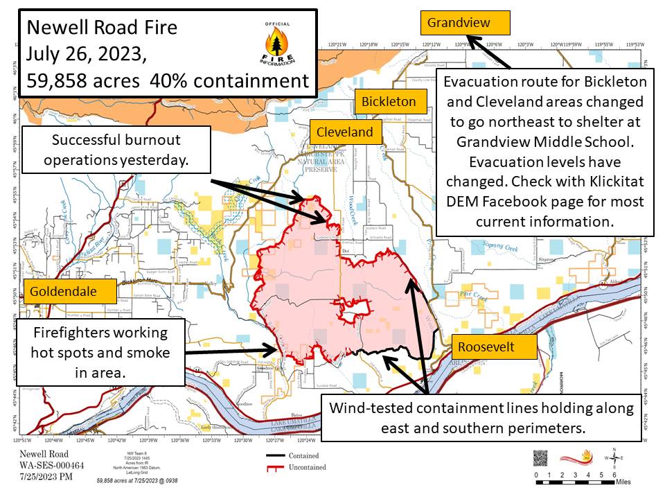
Newell Road Fire Morning Update Wed July 26 2023
Related Incident: NEWELL ROAD
Publication Type: News
Newell Road Fire
Incident Commander: Kevin Stock
Fire Information Phone: 208-713-2740
Media Fire Information Phone: 208-891-7491
Email: 2023.NewellRoad@firenet.gov
Facebook: facebook.com/NewellRoadFire
Inciweb: inciweb.wildlfire.gov/newellroad
Morning Update, July 26, 2023
Estimated size: 59,858 acres
Containment: 40%
Start Date: July 21, 2023
Area of Origin: Klickitat County near Newell Road
Cause: Under Investigation
Structures Damaged: Currently being assessed
Total people assigned: 564
Engines: 48
Dozers: 9
Handcrews: 11
Water Tenders: 10
Skidgen: 3
Overhead: 126
Type 1 Helicopter: 2
Type 2 Helicopter: 2
Air Tankers: As Needed
Thank You to the community members and speakers who attended last night’s Newell Road Fire Community Meeting! A recording of the meeting is available on the Newell Road Fire Facebook page.
Fire Update: Containment of the Newell Road Fire has increased to 40%. Yesterday, firefighters were able to stop forward progression of the spot fire on the east side of Dot Road. Fire personnel took advantage of the overnight conditions (lower temperatures, higher moisture levels and easing winds) to conduct firing operations that will strengthen the northern containment lines. Burnout operations are a tactic used by firefighters to eliminate fuel between the fire’s edge and containment line. Air resources, engines, handcrews and dozers supported the burnout operations.
There was a vehicle accident yesterday on the fire involving a rollover of a water tender. The driver of the water tender has been released from the hospital after receiving medical attention.
Today’s activity: Fire personnel will be working an area on the southwest corner of the fire that is continuing to burn and showing more smoke than the last couple of days. Burnout activity as needed, and mop-up will take place on the northern side of the fire, including the eastern side of Dot Road. Crews will continue to cold trail, mop-up and patrol the eastern and southern edges of the fire to ensure the wind-tested lines continue to hold.
Evacuations and Road Closures: The fire spotting over Dot Road yesterday increased evacuations levels – Bickleton residents are advised to evacuate north and east. For the latest evacuations, please see: http://www.facebook.com/klickitatDEM911
Road closures include: Roosevelt Grade Road, Old Highway 8 north to and including Dot Road. Also closed is Rock Creek Road, Bikelton Highway between Old Mountain Road and the county line, Highway 14 is closed except for local traffic, and Hoctor Road is closed east of Oak Flat.
Temporary Flight Restriction (TFR): TFR is in place over the Newell Road Fire. Please review the Notice to airmen in its entirety.
Sheltering: The American Red Cross has a shelter established at the Goldendale Middle School 520 E. Collins Street, Goldendale, WA. Due to the spotting across Dot Road, a second shelter has opened at Grandview Middle School: 1401 W 2nd St, Grandview, WA
Bowles Creek Fire Update Map for July 26 2023
Related Incident: Bowles Creek Fire
Publication Type: News
Bowles Creek Fire Update for July 26 2023
Related Incident: Bowles Creek Fire
Publication Type: News
Colt Fire Daily Update Wednesday July 26
Related Incident:
Publication Type: News
Colt Fire Fact Sheet
Montana Department of Natural Resources and Conservation Fire Protection
Lolo National Forest and Flathead National Forest Land Management
NORTHERN ROCKIES TEAM 1
INCIDENT COMMANDER: BRENT OLSON
Fire Information: 406-247-0922
Wednesday, July 26, 2023 at 9:00 am
Location: 15 miles northwest of Seeley Lake, Montana
Start Date: 7/17/2023 Cause: Lightning Size: 4,390 acres Containment: 0%
Total Personnel: 467 Engines: 14 Helicopters: 7 Hand Crews: 12
KEY MESSAGE
A Community Meeting has been scheduled for today, July 26 from 7-8pm at the Condon Community Center. Fire personnel will provide updates and be available for questions. We are planning to livestream this public meeting. However, if internet strength makes it difficult to livestream, we will record the meeting and post the video.
CURRENT STATUS
Following the passage of a dry cold front on Monday, Tuesday’s temperatures were cooler, and winds were lighter resulting in moderate fire activity. The overnight infrared mapping flight was unable to obtain an updated size of the fire due to cloud cover over the fire area.
Yesterday, on the east side of the fire, crews worked to contain the spot fires east of Forest Road 646 (Colt/Uhler Road). On the south side, crews looked for opportunities to work on direct fire line along the West Fork of the Clearwater River. The fires edge is currently held up just north of the river. On the north side, crews and equipment started working to reduce vegetation along Forest Road 906 (Beaver Creek Road) and look for access routes and opportunities to work on fire line construction in locations that have a high probability of success to contain the fire. The Structure Protection group has completed numerous structure assessments and continued preparation work in the areas along Highway 83 and around the lakes south and east of the fire. Structure protection efforts include cutting vegetation to create defensible space and setting up pumps, hoses, and sprinklers. Helicopters were effectively used throughout the day to drop water and cool hots spots on the fire.
PLANNED ACTIONS
Personnel will continue to work on securing the spot fires on the east flank and begin to burn ground vegetation in select locations between the fires edge and Forest Road 646 (Colt/Uhler Road). On the south side, crews will construct direct hand line where appropriate and continue to assess road systems as potential control features near the West Fork of the Clearwater River. Crews and a Heavy Equipment Task Force will continue working on vegetation removal and control line preparation along the Beaver Creek Road on the north side of the fire. The north and south Structure Protection Groups will continue structure assessments, remove fuels, and install water handling equipment as needed. Helicopters will be used to drop water on the fire and have been very effective when needed. Firefighter and public safety remain the number one priority as fire suppression work progresses.
WEATHER AND FIRE BEHAVIOR
The temperatures on Wednesday will be as high as 80 degrees and relative humidity levels as low as 20-30%. Light west winds will increase from 9-14 mph in the morning. Winds could gust as high as 21 mph in the afternoon. Fire behavior is expected to be moderate and will move along the active fire edges through the heavy dead and down surface vegetation. Torching and spotting are possible in the subalpine fir and lodgepole pine.
EVACUATIONS AND CLOSURES
The Missoula County Sheriff’s Office Evacuation Warning and Order summary:
-Residents on Beaver Creek Road (near the summit) are under an Evacuation Warning.
-Mile marker 31 (Beaver Creek Road at the intersection of Hwy 83) south towards Seeley Lake to mile marker 27, and including residences in Rovero Flats, are under an Evacuation Order.
-Residences beginning at mile marker 27, south end of Rovero Flats, to mile marker 25.5 (the intersection of the West Fork of the Clearwater Road and Hwy 83) are under an Evacuation Warning.
-Residences on the north and south ends of Lake Inez are under an Evacuation Warning. The east side of Lake Inez, along Hwy 83, is not under any Warning or Order.
For evolving Evacuations and Warnings please visit the Missoula County Sheriff’s Office Facebook page at https://www.facebook.com/MissoulaCountySheriffsOffice .
Please be aware that due to the possibility of rapidly changing conditions, an Evacuation Order may be issued with no prior notice or warning. Home and property owners in the surrounding area should remain vigilant and prepared. Have an evacuation plan for family, pets, and livestock; sign up for emergency alerts at Smart911.com; and be familiar with the Missoula County evacuation process and what an order and warning means https://www.missoulacounty.us/government/public-safety/office-of-emergency-management/evacuation-information.
The Lolo and Flathead National Forests have closed several forest roads, areas, and campgrounds near the fire area for public safety. The list of current closures includes:
-Forest Road 906 (closed at Highway 83)
-Rainy Lake Campground access road 4357 (closed at Highway 83)
-Rainy Lake Campground
-Alva Lake Campground access road (closed by gate at Highway 83)
-Alva Lake Campground
-Lakeside Campground access road (closed by gate at Highway 83)
-Lakeside Campground
-Lake Inez Campground
-Forest Road 646 (closed at the junction of FSR 552; FSR 4354; Forest Road 552 (beyond the turn off to west side Lake Inez access
-Forest Road 5407 and 463 closed beyond the West Side snowmobile trailhead (these roads access the Montana Fish, Wildlife, and Parks Marshall Wildlife Management Area and Lake Marshall)
-Temporarily closing the Forest System Road loops of the Clearwater (FSR 4370 and 4353) and Richmond (FSR 667 and 720)
TEMPORARY FLIGHT RESTRICTIONS
A Temporary Flight Restriction is in place for air space over the Colt Fire (FDC 3/0291) to provide a safe environment for firefighting aircraft operating in the area. Remember that temporary flight restrictions also apply to unmanned aircraft systems (UAS) or drones. If you fly, we can’t!
July 26 2023 Daily Update
Related Incident:
Publication Type: News
NORTHERN ROCKIES TYPE 3 TEAM
INCIDENT COMMANDER: DAN BROWN
Consalus Fire
Priest Lake Ranger District, Idaho Panhandle National Forests
Fire Information 208-996-0980 | 2023.consalus@firenet.gov
https://tinyurl.com/consalusfire
July 26, 2023
Location: 10 miles west of Coolin, ID, in Pend Oreille County, WA
Start Date: 6/30/2023
Cause: Lightning
Size: 475 acres
Containment: 40%
Total Personnel: 205
Equipment: 2 Dozers, 2 Masticators, Excavator, Feller Buncher
Hand Crews: 5 + a district module
Engines: 2
Aircraft: 1 helicopter
Other: 3 Faller Modules, 6 Water Tenders, Ambulance, 2 REMs
The Consalus fire has remained within its existing footprint and 40% contained after a second day of winds testing its perimeters. Firefighters continue to find and extinguish areas of heat in the no name drainage and Consalus Creek areas, which are on the south and southeast sides of the fire. Specialized tree fallers are working to clear the remaining hazard trees and snags in Consalus Creek as well.
Crews have begun backhauling unneeded equipment such as sprinklers, hose, and pumps from the western side of the fire. Fire officials continue to demobilize heavy equipment and overhead that are no longer needed.
The helicopter assigned to the fire has been assisting fires in the surrounding areas while remaining available for our use as needed.
The fire suppression repair plan, outlining all needed repairs on areas affected by fire suppression activities, is in the review process and should soon be ready to guide firefighters while they work to repair the affected areas.
WEATHER AND FIRE BEHAVIOR
Warmer and drier weather is expected to return today with near seasonal temperatures persisting through the weekend. Today's high temperature will be 78 degrees, with a minimum humidity of 32 percent. Winds are predicted from the southwest 3 to 6 mph.
CLOSURES AND SPECIAL MESSAGES
The Idaho Panhandle National Forests issued an emergency closure (Closure Order # 01-04-08-23-003) effective July 18, 2023. This replaced Closure Order #01-04-08-23-002. The emergency closure has been issued for public safety and prohibits all forms of travel on: Forest Service Road (FSR) #1108 from the junction with FSR #333 to the junction with FSR #659; FSR #1094 will remain open for the first 4.5 miles from the junction with FSR #312, but the remainder of FSR #1094 will be closed to the junction with FSR #1108. Additional road closures now include FSR #659 from the junction with FSR #312 to the junction with FSR #659B; FSR #333 from the junction with FSR #2730 to its terminus.
For firefighter and public safety, please avoid the following roads if possible: The remaining portion of FSR #1094 not part of the closure order; FSR #312 from the junction with FSR #333 to the junction with FSR #659; and FSR #333 from Highway 57 to the junction with FSR #1108. Please refer to the incident PIO map for a visual explanation.
The Temporary Flight Restriction (TFR) over the fire area was released last night (7/25) at 6 p.m. Even though the TFR is no longer in place we will still be using aircraft when needed. Therefore, for the safety of our aerial resources and firefighters on the ground, please do not fly unmanned aircraft (drones) in the fire vicinity. If you fly, we can't.
072623 Fire containment increases Oregon State Fire Marshal resources begin demobilization
Related Incident: Golden Fire
Publication Type: News
Fire containment increases, Oregon State Fire Marshal resources begin demobilization
Bonanza, Ore – Crews have made significant progress on the Golden Fire. Containment has increased to 15% and the fire perimeter is now fully lined. Crews continued mop-up operations through the night and checked for hot spots. Today, crews will continue to secure, improve, and hold control lines. Mop-up operations will continue, working toward the goal of 100% containment. Due to successful mop-up operations, electric utility contractors and fiber optic employees now have access to safely restore connectivity to residents in the coming days.
Oregon State Fire Marshal (OSFM) resources will wrap up their work, expanding mop-up to 50 feet around structures and assisting wildland partners. OSFM resources will begin demobilizing three task forces this morning, leaving three structural task forces assigned to the fire. All remaining OSFM task forces and the Incident Management Blue Team will head back to their home agencies tomorrow.
Klamath County Sherriff’s Office has released a statement ruling out a marijuana grow as the cause of the fire. The cause remains under investigation.
Last night, fire officials held a meeting at Bonanza School, with approximately 125 attendees. The Incident Management Teams appreciate the impressive community participation and support. Attendees expressed their gratitude for the rapid response and hard work of local agencies, OSFM and Oregon Department of Forestry (ODF) resources, and wildland fire partners.
Oregon Department of Forestry IMT 2, Oregon State Fire Marshal, Blue Team
Matt Howard, ODF Incident Commander
Scott Magers, OSFM Incident Commander
Email contact— Goldenfireinfo2023@gmail.com
Public Information Line: (541) 887-0928
Facebook—www.facebook.com/GoldenFire2023/
Grapevine Daily Update July 26 2023
Related Incident:
Publication Type: News
Grapevine Fire
July 26, 2023 – Daily Update
Firefighters Provide Suppression to Protect Communities
Location: Mingus Mountain, Verde Ranger District (T14N, R2E, SEC 4), Approximately 10 miles east of Prescott Valley; 2 miles south of Mingus Spring Ranch
Start Date: July 21, 2023
Size: Approximately 998 acres
Percent Contained: 0%
Cause: Lightning
Vegetation: Brush, Timber and Short Grass
Resources: 1 Type 1 Crew, 5 Type 2 Crews, 12 Engines, 1 Dozer, 2 Helicopters and additional support personnel
Number of Personnel Assigned: 236
Update: Today firefighters will continue to monitor the fire along the western perimeter control lines. Crews continue hand pre that includes removing of vegetation and exposing bare ground along Forest Road 132 and the perimeter of the 4H Camp. Construction of containment features utilizing ground resources and heavy equipment; scout the eastern side of the fire for potential control lines with highest probability of success to contain the fire. Utilize gained knowledge of fire conditions, weather over the fire area and current fire behavior to ensure safety of firefighters. Due to terrain and limited access; firefighters continue to identify hazards as they begin to safely suppress the fire.
Possible afternoon showers are predicted for today, along with associated strong gusty winds and lightning.
Smoke: Smoke may be visible from multiple locations including Prescott Valley, Dewey, Prescott and along Highway 169.
Fire Restrictions: The entire Prescott National Forest is under Stage 1 Fire Restrictions which prohibits building, maintaining, attending, or using a fire, campfire, or stove fire, including charcoal and briquettes, outside a structure that is provided by the Forest Service within designated areas for portions of the forest. Under these restrictions, discharging a firearm, air rifle or gas gun, except for persons engaged in legal hunting activities, is prohibited on the Prescott National Forest. Fireworks and the use of exploding targets are always prohibited year-round on national forests.
Yesterday, an evacuation of the Whitehorse community was conducted by the Yavapai County Sheriff’s Office due to the threat of fire burning towards the area.
For current evacuation information contact the Yavapai County Sheriff’s Office at 928-771-3260 or follow them at https://www.facebook.com/YavapaiCountySheriff.
Recreationists on Mingus Mountain should avoid camping and hiking near the fire and utilize caution while driving the roads as firefighters will be traveling to and from the fire.
For fire information please call (928) 925-1111; or stay up to date on Prescott National Forest news by checking the Prescott NF website and following us on Facebook and Twitter.
Racetrack Fire Update July 26 2023
Related Incident: 2023 Racetrack Fire
Publication Type: News
Racetrack Fire Update - July 26, 2023
Location: North of Highway 169, south of Crater Mountain near the community of Cherry
Start Date: July 23, 2023
Size: 405 acres
Cause: Lightning
Containment: 20%
Resources: 1 Type-1 Crew, 7 Type-2 Crews, 4 Engines, 1 Dozer and additional support personnel.
Fire behavior: Moderate fire behavior
Types of vegetation in the area (aka fuels): Grass, Brush
SUMMARY: Fire activity declined Monday over the Racetrack Fire increasing containment to 20%. Although area thunderstorms to date have not supplied significant rain on the fire, they have been a daily event in the surrounding area and have increased humidity levels. The effect has been diminished fire activity as lighter fuels absorb moisture associated with higher humidity and quickly becoming less flammable and unavailable to ignite larger fuels. Unburned heavy fuels in the interior of the Racetrack Fire continue to burn; some smoke may be visible as these fuels burn. Resources will continue working on reinforcing the control line on the northern perimeter.
Fire managers are crediting the slowing of forward progression into the community of Cherry to previous prescribed fire prepping where firefighters put in control lines strategically located south of Cherry. This gave firefighters the upper hand in stopping the fire from moving into the community.
Possible afternoon showers are predicted for today, along with associated strong gusty winds and lightning.
Evacuations – Please follow Yavapai County Sheriff’s Office Facebook page for current evacuation information at: https://www.facebook.com/YavapaiCountySheriff or call their non-emergency number at 928-771-3260.
FIRE RESTRICTIONS: The entire Prescott National Forest is under Stage 1 Fire Restrictions which prohibits building, maintaining, attending, or using a fire, campfire, or stove fire, including charcoal and briquettes, outside a structure that is provided by the Forest Service within designated areas for portions of the forest. Under these restrictions, discharging a firearm, air rifle or gas gun, except for persons engaged in legal hunting activities, is prohibited on the Prescott National Forest. Fireworks and the use of exploding targets are always prohibited year-round on national forests.
For fire information please call (928) 925-1111; or stay up to date on Prescott National Forest news by checking the Prescott NF website and following us on Facebook and Twitter.