
Golden Fire Daily Evening Update July 27 2023
Related Incident: Golden Fire
Publication Type: News
Winds will test holding lines tomorrow and Saturday.
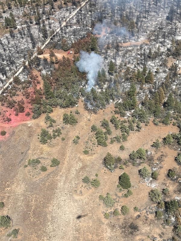
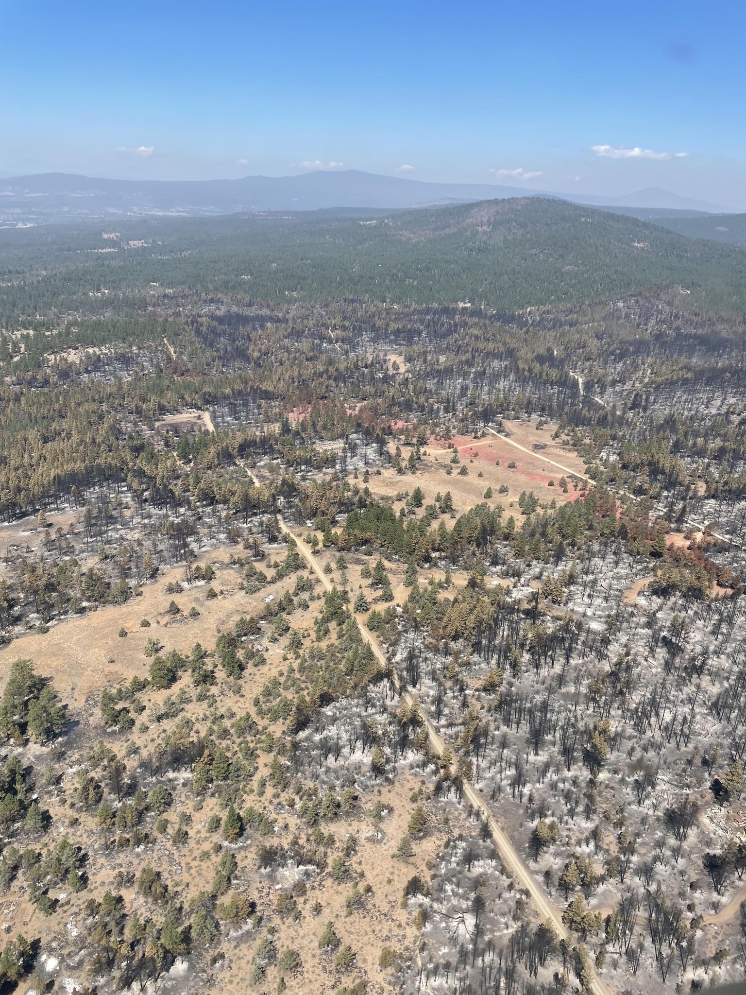
BONANZA, Ore. – Firefighters have done an outstanding job of keeping the fire in check. The winds and high temperatures expected on Friday and Saturday will test the existing holding lines. In the meantime, day and night shift crews will continue to gain depth in mop-up operations.
Crews will assess the unburned areas within and along the fire’s perimeter using infrared cameras to detect heat signatures. This will help the night and day resources during mop-up as the camera detects heat that may be unseen by the naked eye. Heat is known to linger in the duff layer under juniper trees. Removing the heat now will reduce the risk of flare ups later.
Contractors for Pacific Power and Lumen Technologies completed their line work on the main line through the fire area. The next step will be to restore power to individual houses from the main line. Trees Inc. is working to remove hazard trees along powerline easements.
There is currently a red flag warning issued for Klamath County. This will not affect the fire as it is issued just outside the area. It is expected to be hot, dry, and windy through the weekend. Temperatures will continue to increase into next week.
Evacuations downgraded as of Thursday, July 27 at 11:00 a.m.:
- Level 2 (BE READY)- all areas inside the fire perimeter.
All other evacuations have been lifted. While evaluations are reduced, it is always a good idea to stay vigilant and prepared during fire season. For public and firefighter safety, we urge the public to drive slow in the fire area and watch out for overhead hazards.
For the most current evacuation information, call the Klamath County hotline at 541-205-9730, and sign up for Klamath County alerts at
http://alerts.klamathcounty.org. American Red Cross and Klamath County Community Emergency Response Team (CERT) have established an evacuation shelter at Bonanza School, 31601 Mission Street, Bonanza, OR 97623.
Tomorrow the local fire district of the South-Central Oregon Fire Management Partnership will increase the fire danger to extreme for Klamath and Lake counties. During these conditions fires may spread rapidly. Be sure to prevent anything that can spark a wildfire. For more information on the release and other restrictions visit: http://scofmp.org/
Newell Road Fire morning update Thurs July 28 2023
Related Incident: NEWELL ROAD
Publication Type: News
Morning Update, July 28, 2023
Estimated size: 61,313 acres
Containment: 71%
Start Date: July 21, 2023
Area of Origin: Klickitat County near Newell Road
Cause: Under Investigation
Structures Damaged: Currently being assessed
Fire Update: Fire activity has remained minimal with only a few interior smokes and hotspots to extinguish. Firefighters continue to take advantage of favorable weather conditions (higher humidity, lower temperature, lighter winds) to improve and secure control lines. Fire containment is now at 71% and is expected to continue to increase as suppression work continues. Although the strength of containment is increasing, smoke coming from the interior of the fire (sometimes miles inside containment lines) is likely to be visible.
Today’s planned activity: Firefighters will continue to mop-up and secure containment lines along the entire perimeter of the fire. Air operations will be conducting an aerial reconnaissance over the fire this morning to provide ground operations information in support of suppression efforts, including identification of areas for future suppression repairs. If needed, firefighters will use air resources to conduct water drops on interior hotspots. The fire spike (remote) camp at Bickleton School will be closing at the end of shift today and all resources staying there will be reporting to Goldendale this evening.
Transfer of command of the fire operation planned for Sunday: The overall objective for future management of the fire suppression efforts is to have the fire sufficiently secured and contained to allow for the transfer of management back to local fire and agency resources on Sunday morning. Fire resources no longer required to meet containment objectives are being demobed (released) so they can be reassigned to other fires or return to their home bases. Northwest Incident Management Team 8 wishes to thank all of the fire resources for their efforts!
Evacuations: Bickleton and Cleveland area residents are advised that the evacuation route is now to the northeast to Grandview. For the latest evacuation information, please see: https://www.klickitatcounty.org/249/Emergency-Management .
Road closure updates: As of 5 PM yesterday, Klickitat County Department of Emergency Management (DEM) updated the road closure conditions related to the Newell Road Fire. Please refer to the Klickitat DEM Facebook and Website for the most current closure information: https://www.klickitatcounty.org/249/Emergency-Management .
Temporary Flight Restriction (TFR): TFR is in place over the Newell Road Fire.
Sheltering: The American Red Cross in Goldendale is on standby. If needed, a second shelter has opened at Grandview Middle School: 1401 W 2nd St, Grandview, WA.
Flat Fire Evening Update 7272023
Related Incident: Flat Fire
Publication Type: News
July 27, 2023
Flat Fire Evening Update
Size: 23,678
Start Date: July 15, 2023
Point of origin: 2 miles southeast of Agness, OR
Containment: 10%
Cause: Human caused, Under Investigation
Total personnel: 1,644
Resources: 50 engines l 38 crews l 8 bulldozers l 34 water tenders l 8 masticators l 11 helicopters
Current Situation: Aerial resources helped reinforce control features along the southern perimeter by dropping retardant east of the Game Lake area. Helicopters also dropped buckets of water along the southeast perimeter to moderate fire behavior and slow its progression to the east. Firefighters took advantage of favorable weather conditions and used firing operations to secure additional control lines along Forest Road (FR) 3680 down to the Snow Camp area. Four rappellers were deployed to the small spot fire which is still displaying minimal fire activity off the southeastern edge of the main fire.
Tonight’s activities: Rappellers will begin suppressing and mopping up the spot fire directly along the fire’s edge. If weather conditions allow, firefighters will continue burnout operations along FR 3680 working south towards FR 402. Resources will also mop up previously burned areas and extinguish sources of heat further in from control lines across the fire.
Evacuations: A Level 1 “Get Ready” evacuation notice remains in effect for areas on the north side of the Rogue River in Old Agness up to Illahe Lodge and along the Rogue River Corridor from Quosatana Creek Campground to the Agness area. This includes the areas of Spud Road, Old House Creek Road and Oak Flat.
The area immediately east of Agness remains in a Level 2 due to an abundance of caution. Some areas outside the burn area to the southwest will remain in Level 2 while fire crews continue to further secure control lines. The Curry County Sheriff’s Office will continue to coordinate with the Fire Incident Management Team and will notify all residents affected by the fire of any reasons to change evacuation levels. Curry County is using Everbridge to send evacuation notices. You can sign up for notifications here: https://www.co.curry.or.us/departments/emergency_management/index.php.
Weather: Weather conditions will likely warm and dry over the next few days. Winds are predicted from the northeast to northwest, with gusts around 20 mph.
Smoke: The Smoke Outlook is available at: https://outlooks.airfire.org/outlook/en/b74901f7
Closures: The Rogue River Siskiyou National Forest has issued a closure order for the fire area including trails, roads and a portion of the Illinois River. Oak Flat Campground, Game Lake Campground, Wild Horse Campground and Snow Camp Lookout Recreation Rentals are all closed as part of the area closure. More information can be found here: bit.ly/RRSNFClosures.
Restrictions: Fire Restrictions are in place, to learn more visit: fs.usda.gov/rogue-siskiyou
Campfires are only permitted in designated campgrounds that have metal fire rings. Ensure your campfire is thoroughly extinguished before leaving.
Fire Information:(541)216-4579 Media inquiries: (541)237-6369 Email: 2023.flat.or@firenet.gov
Blum Fire Structure Loss Update July 27 2023
Related Incident: Blum Fire
Publication Type: Announcement
It was initially reported that five homes were destroyed by the Blum Fire in Hill County. After further assessment of the burned area, this was determined not to be true. No homes have been destroyed by the fire. One outbuilding, however, is confirmed to have been lost to the fire.
Spoon Fire Closures
Related Incident: Spoon Fire
Publication Type: Closures
There are no road closures associated with the Spoon Fire. Highway 60 is open. For more information on road conditions visit https://azdot.gov/maps.
Fire Restrictions Begin July 28th on the Eldorado National Forest July 27 2023
Related Incident:
Publication Type: News
Fire Restrictions Begin July 28th on the Eldorado National Forest
Placerville, Calif, July 27, 2023 - Due to drier conditions increasing, seasonal fire restrictions will go into effect Friday, July 28, 2023 on the Eldorado National Forest under Forest Order 03-23-11. Under these restrictions, wood and charcoal fires are only allowed in metal fire rings and grills at designated developed recreation sites listed in the order.
“We appreciate the cooperation of residents and visitors who help prevent human caused wildfires by following these fire restrictions,” said Forest Fire Management Officer Nickie Johnny. “We have already encountered some abandoned campfires this year, so if you see an abandoned or illegal fire, call 911."
To protect public safety, the following acts are prohibited on the Eldorado National Forest:
- Building, maintaining, attending, or using a fire, campfire, or stove fire, except within stoves, charcoal grills or fire rings provided in the Developed Recreation Sites, as shown on Exhibit A. 36CFR 261.52(a).
- Smoking, except within an enclosed vehicle or building, a Developed Recreation Site as shown on Exhibit A, or while stopped in an area at least three feet in diameter that is barren or cleared of all flammable material. 36 CFR 261.52(d).
- Welding, or operating an acetylene or other torch with an open flame. 36 CFR 261.52(i).
- Operating or using any internal or external combustion engine without a spark arresting device that is properly installed, maintained, and in effective working order in accordance with U.S. Forest Service standard 5100-1. 36 CFR 261.52(j).
Having a valid California Campfire Permit does not exempt a person from the prohibitions listed above. However, persons with a valid California Campfire Permit may use a portable propane campfire pit, stove, or lantern that uses gas, kerosene, jellied petroleum, or pressurized liquid fuel, with a shut-off valve, in an area at least three feet from any flammable materials.
Persons with a valid Forest Service special use authorization for a recreation residence, or a resort or organizational camp listed as an exempted facility in this order are exempt from Prohibition No. 1, while at their permitted location. See exhibit A.
The fire restrictions and forest order can be found on the forest website at www.fs.usda.gov/eldorado under the regulations section. California Campfire Permits are available online at www.readyforwildfire.org/prevent-wildfire/campfire-safety/.
Picture of Fire Restrictions Letter for ENF 7-28-23
Cottonwood Ridge Fire Update July 27 2023
Related Incident: Cottonwood Ridge Fire
Publication Type: News
Size: 411 acres
Containment: 0%
Road Closures: None
Total Personnel: 52
Jurisdiction: Fort Apache Agency
Reservation: Fort Apache Indian Reservation
Start Date: July 23, 2023
Fire Cause: Lightning
Operational Update: Yesterday, there was no growth on the Cottonwood Ridge Fire and the acreage remains the same. The firelines are holding well and crews will continue to strengthen and secure them over the next few days. The northwest flank remains a priority as firefighters continue efforts to secure that side of the fire.
Mark Bernal, Incident commander Type 2 and his Incident Management Team will assume command of the Cottonwood Ridge, Spoon and Mustang Ridge fires on the Fort Apache Indian Reservation at 600 p.m. on Thursday, July 27, 2023.
Management Objective: Reduce fire size using aircraft, giving firefighters time to assess the fire landscape. Firefighters are working on full suppression tactics for this fire.
Safety: The health and safety of firefighters and the public are always the priority. Members of the public should avoid the fire area.
Values at risk: Potential communities at risk include Linden to the north of the Cottonwood Ridge Fire, but it’s NOT an immediate threat at this time. Citizens should always be “Ready” for any emergency by having a kit, being on the Ready Navajo County Alert System (sign up here: https://member.everbridge.net/453003085612436/login) and watch Fort Apache Facebook page, https://www.facebook.com/BIAFAAFireMgt for accurate information. Should the need arise to go into “SET”, an alert will be sent, as well as posts added to our social media and on www.311info.net. Highway 60 may be impacted and is located east of the fire.
Smoke: Go to https://fire.airnow.gov/ to see the latest smoke conditions in your community. Smoke may be visible from the surrounding communities and along Highway 60.
Primary and Cooperating Agencies: Bureau of Indian Affairs, White Mountain Apache Tribe, Navajo County, and US Forest Service.
Cottonwood Ridge Fire Update July 26 2023
Related Incident: Cottonwood Ridge Fire
Publication Type: News
Quick Facts
Size: 411 acres
Containment: 0%
Road Closures: None
Total Personnel: 52
Jurisdiction: Fort Apache Agency
Reservation: Fort Apache Indian Reservation
Start Date: July 23, 2023
Fire Cause: Lightning
Operational Update
Yesterday, there was a 10-acre slop over along Cottonwood Canyon on the east flank of the fire. Firefighters lined and secured the slop over. The retardant lines are holding the west and north flank of the fire.
This morning, fire mangers flew the fire and observed that the fire was active in the northwest flank. Firefighters will work today to secure the fire and continue line construction where necessary. Air resources will continue to support the fire.
A Type 2 Incident Management Team is on order to assume command of the Cottonwood Ridge, Spoon and Mustang Ridge fires on the Fort Apache Indian Reservation at 0600 a.m. on Thursday, July 27, 2023.
Management Objective: Reduce fire size using aircraft, giving firefighters time to assess the fire landscape. Firefighters are working on full suppression tactics for this fire.
Safety: The health and safety of firefighters and the public are always the priority. Members of the public should avoid the fire area.
Values at risk: Potential communities at risk include Linden to the north of the Cottonwood Ridge Fire, but it’s NOT an immediate threat at this time. Citizens should always be “Ready” for any emergency by having a kit, being on the Ready Navajo County Alert System (sign up here: https://member.everbridge.net/453003085612436/login) and watch Fort Apache Facebook page, https://www.facebook.com/BIAFAAFireMgt for accurate information. Should the need arise to go into “SET”, an alert will be sent, as well as posts added to our social media and on www.311info.net. Highway 60 may be impacted and is located east of the fire.
Smoke: Go to https://fire.airnow.gov/ to see the latest smoke conditions in your community. Smoke may be visible from the surrounding communities and along Highway 60.
Primary and Cooperating Agencies: Bureau of Indian Affairs, White Mountain Apache Tribe, Navajo County, and US Forest Service.
Hutchinson Fire July 27 2023 Update Magdalena Ranger District
Related Incident:
Publication Type: News
Hutchinson Fire – July 27 Update
Magdalena Ranger District
Reported fire start date / time: July 23, 2023 / 1300. Cause: Lightning Strike Size: 425 acres.
Location: Remote mountainous terrain of central west San Mateo Mts. on the Magdalena Ranger District – New Mexico on the Cibola National Forest & National Grasslands.
Strategy: Fire managers are managing the Hutchinson Fire using a confine and contain strategy.
Update: Crews will continue constructing control lines along Forest Roads 94, 96 and 478 to be utilized as part of the containment line, keeping the fire within the identified planning area. Additional use of hand and aerial ignition may occur to remove available fuels between the active fire and containment features. Firefighters continue to actively monitor the fire and are strategically initiating burnout operations.
On Scene: Type 3 Incident Commander, Magdalena RD Crew 3 & Engine 631, Wallowa-Whitman NF Engine 653, Lewis & Clark NF Engine 661, Firestorm 5 Type 2IA Crew, NMFD Type 2IA Crew, Cochiti Pueblo Water Tender 83 and Sandia Helitack Type 3 Helicopter.
Fuels: Grass, timber and brush.
Containment: 0%.
Values at risk: The Hutchinson Fire is not a threat to any values at risk or communities, and there are no evacuations in effect.
Safety: The health and safety of firefighters and the public are always the first priority. There are no road closures at this time related to the Hutchinson Fire, but members of the public should avoid the area to allow for fire operations.
Drones pose a serious risk to firefighting and can cause air operations to cease. The public is reminded that “If you fly, we can’t!”
Smoke may be visible from NM 107 south of Magdalena, NM 52 south, Community of Dusty and within a 50-mile radius of the Hutchinson Fire. Smoke-sensitive individuals and people with respiratory problems or heart disease are encouraged to take precautionary measures. Information on air quality and protecting your health can be found online at the New Mexico Department of Health (NMDOH) Environmental Public Health Tracking (EPHT) website nmtracking.org. An interactive smoke map is available at https://fire.airnow.gov/, which allows you to zoom into areas to see the latest smoke conditions.
Weather for Magdalena NM: Today: Scattered showers and thunderstorms after noon. Increasing clouds, with a high near 92. Northwest wind 5 to 15 mph becoming east in the afternoon. Chance of precipitation is 50%. New rainfall amounts of less than a tenth of an inch, except higher amounts possible in thunderstorms. Tonight: Scattered showers and thunderstorms, mainly before 9 pm. Cloudy, then gradually becoming partly cloudy, with a low around 65. West wind 10 to 15 mph becoming southeast 5 to 10 mph after midnight. Chance of precipitation is 50%. New precipitation amounts of less than a tenth of an inch, except higher amounts possible in thunderstorms. https://www.weather.gov/
Hutchinson Fire updates will be posted on the Cibola NF & NGs website, New Mexico Fire Information website, inciweb.nwcg.gov and the Cibola NF & NGs Facebook & Twitter pages.
Midnight Fire Daily Update July 27 2023
Related Incident:
Publication Type: News
Daily Update July 27, 2023
Location: Forest Service Road (FSR) #284 (Elk City Wagon Road) 1 mile east of China Point, 3 miles Northwest of Pilot Knob near Mountain House Site
Start Date: 7/10/23 Cause: Lightning Size: 179 acres Completion/Containment: 25%
Total Personnel: 192
Engines: 3 Wildland Engines and 4 Tactical Water Tenders
Dozers: 2 Forest Masticators: 2 Helicopters: 1
Retardant Tankers: As Needed
Hand Crews: 5 on scene including 3 Interagency Hotshot Crews
CURRENT SITUATION
A Wyoming Type 3 Team has assumed command of the Midnight Fire. Heavy firefighting traffic is still expected to continue through the week on Forest Service Roads (FSR) #244, #284, and #1852 as resources continue to contribute to the suppression effort. Heavy equipment is being utilized to construct contingency line on FSR #1853 and #1855, and in Peasley Creek drainage area FSR #469 to #648. A fire camp is still established near McComas Meadows (Camp 58) to support the ongoing suppression efforts.
PLANNED ACTIONS
Direct attack, hand line and suppression efforts around perimeter of fire continues. Continued assessment of existing road and trail systems for heavy equipment use for construction of contingency line.
WEATHER AND FIRE BEHAVIOR
Partly cloudy with a chance of thunderstorms in the morning. Cooler temperatures in the afternoon with terrain driven winds increasing in the afternoon. Minimal precipitation over the fire is expected. Fire behavior is moderate with torching, group torching, and creeping. Fire growth has been minimal over the last few days but could change with weather conditions. Air quality information can be found at: AirNow Interactive Map (epa.gov)
CLOSURES AND SPECIAL MESSAGES
There are currently no closures in place, but firefighting traffic is expected to be heavy along FSR # 244 (Lighting Creek Road) and FSR# 284 (Elk City Wagon Road) between China Point and Lytle Cow Camp, while suppression operations are taking place. Fire Management Officials urge the traveling public to please avoid this area both on the ground and in the air. There is a Temporary Flight Restriction (TFR) in place over the Midnight Fire area for the safety of the aviation resources on scene.