
Bedrock Fire Update for July 29 2023
Related Incident: Bedrock Fire
Publication Type: News
Lowell, Ore. – The Bedrock Fire continued to spread yesterday, with much of the growth in the Hehe and Andy creek drainages, and along Fall Creek toward the east. The fire progressed slower where there is less fuel, including in the 2021 Gales Fire perimeter. Similar growth and fire activity is expected today.
Additional personnel and equipment continue to arrive at the Bedrock Fire. These reinforcements, which include both engines and hand crews, have allowed fire managers to insert resources into areas east of the fire. Firefighters are identifying locations where fire lines can be established with both a likelihood of success and a low risk of serious injury to firefighters.
Firefighters are constructing fire line along ridges which offers a greater chance of stopping the fire while reducing risk and hazards. Ridgelines often have less vegetation and may have ground gentle enough for bulldozers and other heavy equipment. A line across the middle of a steep slope is much more likely to have fire push across it than one along a ridgeline. The hazards of falling trees and rolling or sliding logs are much greater when constructing a fire line across a steep slope, endangering personnel.
WEATHER: Saturday will be another sunny, dry day, with high temperatures around 80 degrees and relative humidity dropping to 30 to 35 percent. Similar weather conditions are expected into next week.
SAFETY: Willamette National Forest has issued a Forest Closure Order for the area around the Bedrock Fire. Please stay out of the closure area for your safety and the safety of fire personnel. Unmanned aerial systems (AES or drones) are not permitted within the Temporary Flight Restriction.
SMOKE: Smoke from the Bedrock Fire will continue to spread into central Oregon, causing some areas to experience “unhealthy” conditions. Individuals with respiratory issues may find themselves affected by the smoke.
York Fire Update 72923 950am
Related Incident: 2023 - York Fire
Publication Type: News
July 29, 2023 - Update - The York Fire is at 4,200 acress and 0% contained. It remained active throughout the night and is burning in brush and timber. These fuels can be particularly difficult due to the abundance of dry fuel and can lead to long fire runs and high flames. The Fire management team is employing a well-coordinated approach to combat the fire in brush and timber.
The focus today is on containment and suppression efforts, this is critical to limit the fire's spread and protect nearby areas and communities. Establishing control lines through natural barriers or firebreaks can help create boundaries that the fire cannot easily cross, aiding in its confinement.
Crews will be using aircraft for fire retardant drops, which is an important strategy to assist in slowing down the fire's progression and create containment lines. The fire retardant helps to reduce the fire's intensity and limit its ability to spread further.
Meanwhile, the efforts of firefighters on the ground will work to establish more direct access to the fire, to increase their effectiveness in suppressing it. Their dedication and bravery in tackling the flames at close range significantly enhance the effectiveness of firefighting operations.
Dealing with wildfires is a challenging and hazardous task, but the coordinated efforts of the fire management team and the commitment of firefighters are instrumental in mitigating the impact of the fire.
As always, it's important to stay updated on official information and follow safety instructions given by local authorities. If you're in the vicinity of the fire, please take necessary precautions to ensure your safety and the safety of those around you.
No Evacuations at this time.
No Closures at this time.
Colt Fire Daily Update Saturday July 29
Related Incident:
Publication Type: News
Colt Fire Fact Sheet
Montana Department of Natural Resources and Conservation Fire Protection
Lolo National Forest and Flathead National Forest Land Management
NORTHERN ROCKIES TEAM 1
INCIDENT COMMANDER: BRENT OLSON
Fire Information: 406-247-0922 2023.Colt@firenet.gov Facebook: https://www.facebook.com/ColtFire
https://inciweb.wildfire.gov/incident-information/mtmts-colt-fire
Saturday, July 29, 2023 at 9:00 am
Location: 15 miles northwest of Seeley Lake, Montana
Start Date: 7/17/2023 Cause: Lightning Size: 5,475 acres Containment: 3%
Total Personnel: 570 Engines: 16 Helicopters: 5 Hand Crews: 14
KEY MESSAGE
Structure protection preparation begins before the wildfire starts. Homeowners can prepare by cleaning needles and leaves from roofs and gutters, stacking firewood away from buildings and decks, and reducing close vegetation around their structures to create defensible space.
CURRENT STATUS
Crews conducted burning operations on the southeast corner and north side of the fire yesterday. Fire activity was observed as moderate under slightly warmer and drier weather conditions. The overnight infrared flight mapped the fire at approximately 5,475 acres in size, increasing by 223 acres.
Yesterday, crews continued to secure the fires edge along Forest Road 646 (Colt/Uhler Road) while additional personnel conducted burning operations on the north side and southeast corner of the fire. The intent of these operations is to eliminate the unburned fuel between the fires edge and the road allowing crews and engines to be able to mop up in an area of reduced risk that has a high probability of stopping any additional fire movement to the east. Firefighters responded to a 2-acre spot fire north of Colt Lake and were successful in containing it. A Heavy Equipment Task Force continued work reducing vegetation along Forest Road 906 (Beaver Creek Road) in case the road needs to be used as a control line to stop northerly fire spread. On the southwest corner aircraft retardant drops were done to check fire spread while personnel searched for opportunities to construct fire line in locations that have a high probability of success to contain the fire. South Structure Protection worked on structure assessments on Lake Inez. North Structure Protection assisted in operations along Forest Road 646 (Colt/Uhler Road) while being prepared to respond if conditions changed. Helicopter bucket water drops were effectively used to cool hots spots.
PLANNED ACTIONS
Crews will hold and secure the eastern control lines along Forest Road 646 (Colt/Uhler Road) as well as on the north side of the fire where burning operations have taken place. On the southeast corner, crews will continue burning operations and work on securing that area and tying in with Road 646. On the south side, crews will look for potential control features north of the West Fork of the Clearwater River. To the north, the Heavy Equipment Task Force will continue working on control line preparation along the Beaver Creek Road. South Structure Protection will conduct structure assessments and protection work at Lake Inez. A night shift of engines and personnel will patrol and monitor fire conditions. Helicopters and airplanes will be used to drop water and retardant on the fire as needed.
WEATHER AND FIRE BEHAVIOR
The high temperatures in the fire area on Friday will range from 71-81 degrees, with relative humidity levels at 20-30%. Winds will be from the south at 5-9 mph with gusts up to 12 mph. There is a 30% chance of thunderstorms over the area and thunderstorm outflow winds could potentially gust to 30 mph. Fire behavior is expected to be moderate with the active fire edge moving through the heavy dead and down surface vegetation. Torching and spotting are possible in the subalpine fir and lodgepole pine.
EVACUATIONS AND CLOSURES
The Missoula County Sheriff’s Office Evacuation Warning and Order summary:
-Residents on Beaver Creek Road (near the summit) are under an Evacuation Warning.
-Mile marker 31 (Beaver Creek Road at the intersection of Hwy 83) south towards Seeley Lake to mile marker 27, and including residences in Rovero Flats, are under an Evacuation Order.
-Residences beginning at mile marker 27, south end of Rovero Flats, to mile marker 25.5 (the intersection of the West Fork of the Clearwater Road and Hwy 83) are under an Evacuation Warning.
-Residences on the north and south ends of Lake Inez are under an Evacuation Warning. The east side of Lake Inez, along Hwy 83, is not under any Warning or Order.
If conditions rapidly change an Evacuation Order may be issued with no prior notice or warning. Home and property owners in the surrounding area should remain vigilant and prepared. Have an evacuation plan for family, pets, and livestock; sign up for emergency alerts at Smart911.com; and be familiar with the Missoula County evacuation process and what an order and warning means by clicking on the following link: https://www.missoulacounty.us/government/public-safety/office-of-emergency-management/evacuation-information. For evolving Evacuations and Warnings please visit the Missoula County Sheriff’s Office Facebook page at https://www.facebook.com/MissoulaCountySheriffsOffice .
The Lolo and Flathead National Forests have closed several forest roads, areas, and campgrounds near the fire area for public safety. The list of current closures includes:
-Forest Road 906 (closed at Highway 83)
-Rainy Lake Campground access road 4357 (closed at Highway 83)
-Rainy Lake Campground
-Alva Lake Campground access road (closed by gate at Highway 83)
-Alva Lake Campground
-Lakeside Campground access road (closed by gate at Highway 83)
-Lakeside Campground
-Lake Inez Campground
-Forest Road 646 (closed at the junction of FSR 552; FSR 4354; Forest Road 552 (beyond the turn off to west side Lake Inez access
-Forest Road 5407 and 463 closed beyond the West Side snowmobile trailhead (these roads access the Montana Fish, Wildlife, and Parks Marshall Wildlife Management Area and Lake Marshall)
-Temporarily closing the Forest System Road loops of the Clearwater (FSR 4370 and 4353) and Richmond (FSR 667 and 720)
TEMPORARY FLIGHT RESTRICTIONS
A Temporary Flight Restriction is in place for air space over the Colt Fire (FDC 03/0291) to provide a safe environment for firefighting aircraft operating in the area. An airport closure is in place for the Condon Airstrip (FDC 07/110) for firefighting helicopter operations. Remember that temporary flight restrictions also apply to unmanned aircraft systems (UAS) or drones. If you fly, we can’t!
July 29 2023 Daily Update
Related Incident:
Publication Type: News
NORTHERN ROCKIES TYPE 3 TEAM
INCIDENT COMMANDER: DAN BROWN
Consalus Fire
Priest Lake Ranger District, Idaho Panhandle National Forests
Fire Information 208-996-0980 | 2023.consalus@firenet.gov
https://tinyurl.com/consalusfire
July 29, 2023
Location: 10 miles west of Coolin, ID, in Pend Oreille County, WA
Start Date: 6/30/2023
Cause: Lightning
Size: 475 acres
Containment: 50%
Total Personnel: 154
Equipment: 2 Feller Bunchers, Skidgen, Dozer, Masticator, Excavator
Hand Crews: 3 + a district module
Engines: 1
Other: 2 Faller Modules, 5 Water Tenders, Ambulance, 2 REMs
Yesterday, crews continued to utilize sprinklers on the south and southeastern edge of the Consalus Fire while they worked to mop up any heat found along the edges. Fire officials reported that the area from no name creek to Consalus Creek is “looking really good”. On the western perimeter, firefighters pulled hose lays and backhauled unneeded equipment while patrolling and monitoring the fires edge. Heavy equipment including a dozer, masticator and processor are working to clear and improve roads that were impacted by fire activity.
The objectives for today remain the same as yesterday with firefighters continuing to secure and monitor the perimeter while working on suppression repair and backhauling equipment that’s no longer needed.
The helicopter that was assigned to the fire has been released but aviation resources are still available in the district if the need arises. For the safety of our aerial resources and firefighters on the ground, please do not fly unmanned aircraft (drones) in the fire vicinity. If you fly, we can't.
We ask the public to please recreate responsibly. The public plays a valuable role in wildfire prevention. On average, 87% of all wildfires are caused by humans each year. If you have a campfire, keep it small, be sure to always attend to it and extinguish it completely prior to leaving. Always have a hose, bucket of water, or shovel and dirt or sand nearby to put the fire out. One Less Spark – One Less Wildfire
WEATHER AND FIRE BEHAVIOR
A weak cold front is expected to push towards the fire tonight. Lower levels of the atmosphere will remain very dry with isolated dry lightning possible Saturday night into Sunday. Today's max temperature is 89 degrees, with a minimum humidity of 24 percent. Today, winds will be light, and terrain driven but an increase in winds is forecasted tomorrow.
CLOSURES AND SPECIAL MESSAGES
The Idaho Panhandle National Forests issued an emergency closure (Closure Order # 01-04-08-23-003) effective July 18, 2023. This replaced Closure Order #01-04-08-23-002. The emergency closure has been issued for public safety and prohibits all forms of travel on: Forest Service Road (FSR) #1108 from the junction with FSR #333 to the junction with FSR #659; FSR #1094 will remain open for the first 4.5 miles from the junction with FSR #312, but the remainder of FSR #1094 will be closed to the junction with FSR #1108. Additional road closures now include FSR #659 from the junction with FSR #312 to the junction with FSR #659B; FSR #333 from the junction with FSR #2730 to its terminus.
For firefighter and public safety, please avoid the following roads if possible: The remaining portion of FSR #1094 not part of the closure order; FSR #312 from the junction with FSR #333 to the junction with FSR #659; and FSR #333 from Highway 57 to the junction with FSR #1108. Please refer to the incident PIO map for a visual explanation.
Flat Fire Morning Update 7292023
Related Incident: Flat Fire
Publication Type: News
July 29, 2023
Flat Fire Morning Update
Start Date: July 15, 2023
Size: 24,951
Point of origin: 2 miles southeast of Agness, OR
Containment: 14%
Cause: Human caused, Under Investigation
Total personnel: 1,736
Resources: 51 engines l 42 crews l 8 bulldozers l 32 water tenders l 8 masticators l
12 helicopters
Current Situation: Fire suppression work is taking place on all sides of the incident. Firing operations on the southwest flank are ongoing. A mobile retardant base is supplying retardant to helicopters to assist firefighters on the ground. Infrared detection is assisting firefighters to locate heat sources. The fire has not impacted the Rogue River and the air quality has been good thus far. Gold Beach and the surrounding area are open for business. Highway 101, Highway 199, and Bear Camp Road are open.
Today’s activities: A combination of firing operations, mop up, patrolling and structure assessment will take place today. Crews are progressing with firing operations on the southwestern flank, working south off Forest Road (FR) 3680. Firefighters are bringing fire west from Game Lake, in order to tie together existing burnout operations. Firing operations on the northeast will be taking place over the next few days, using FR 3577 and FR 150 as control lines. A contingency group that includes Coos Forest Protective Association firefighters is working on alternate containment lines and will be working on a fuel break on FR 1503. Bear Camp Road is being prepared as a alternate line and crews will be working along the road over the next few days. The terrain is very difficult for firefighters to work in, and every precaution is taken to ensure their safety.
Community Meeting: A community meeting will take place on Monday, July 31st, at the Brookings High School in the cafeteria at 6:00 p.m. The address for the school is: 625 Pioneer Rd, Brookings, OR 97415.
Evacuations: A Level 1 “Get Ready” evacuation notice is in effect for areas on the north side of the Rogue River in Agness up to Illahe Lodge and along the Rogue River Corridor from Quosatana Creek Campground to the Agness area. This includes the areas of Spud Road, Old House Creek Road and Oak Flat.
The area immediately east of Agness remains in a level 2, out of an abundance of caution. Some areas outside the burn area to the southwest will remain in Level 2 while fire crews continue to further secure control lines. The Curry County Sheriff’s Office will continue to coordinate with the Fire Incident Management Team and will notify all residents affected by the fire of any reasons to change evacuation levels.
Curry County is using Everbridge to send evacuation notices. You can sign up for notifications here: https://www.co.curry.or.us/departments/emergency_management/index.php.
Weather: Weather conditions will likely remain warm and dry over the next few days. Winds are predicted from the northeast to northwest, with gusts up to 20 mph.
Smoke: The Smoke Outlook is available at: https://outlooks.airfire.org/outlook/en/b74901f7
Closures: The Rogue-River Siskiyou National Forest has issued a closure order for the fire area including trails, roads and a portion of the Illinois River. Oak Flat Campground, Game Lake Campground, Wild Horse Campground and Snow Camp Lookout Recreation Rentals are all closed as part of the area closure. More information can be found here: bit.ly/RRSNFClosures.
Restrictions: Fire Restrictions are in place, to learn more visit: fs.usda.gov/rogue-siskiyou
Ensure your tow chains do not have excess slack. Dragging tow chains on pavement can create sparks which can start wildland fires.
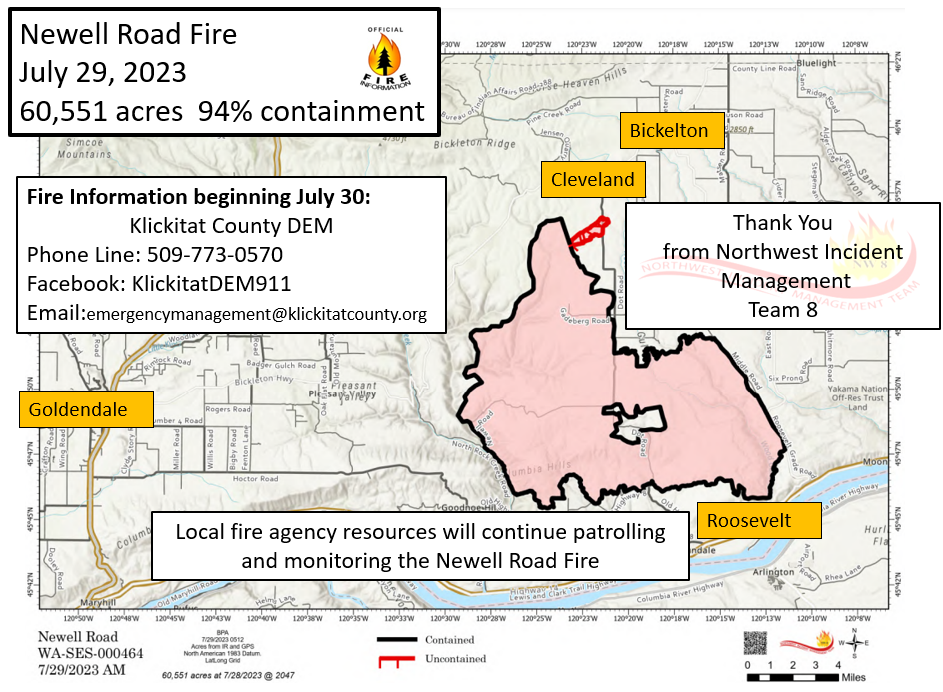
Newell Road Fire Morning Update Saturday July 29th 2023
Related Incident: NEWELL ROAD
Publication Type: News
Incident Commander: Kevin Stock
Fire Information Phone: 208-713-2740
Media Fire Information Phone: 208-891-7491
Email: 2023.NewellRoad@firenet.gov
Facebook: facebook.com/NewellRoadFire
Inciweb: inciweb.wildlfire.gov/newellroad
Total people assigned: 234
Engines: 7
Dozers: 2
Handcrews: 4
Water Tenders: 3
Skidgen: 2
Overhead: 82
Type 1 Helicopter: 2
Type 2 Helicopter: 2
Air Tankers: As needed
Morning Update, July 29, 2023
Estimated size: 60,551 acres
Containment: 94%
Start Date: July 21, 2023
Area of Origin: Klickitat County near Newell Road
Cause: Under Investigation
Structures Damaged: Currently being assessed
Fire Update: The Northwest Incident Management Team 8 (IMT8) will be turning over management of the fire to local fire and agency resources tomorrow morning. Each remaining agency will be providing their own resources for their assigned section of the fire, which will include patrolling and monitoring. Some smoke will likely remain visible, but if you see active fire in the coming days call 911 or the local area non-emergency line 509-773-4545 and local dispatchers will direct those calls as needed. For general enquiries about the Newell
Road Fire call 509-773-0570. The NW IMT8 fire information phone lines will be disconnected at 8 PM tonight, and future Facebook and email communications will be distributed through the Klickitat DEM Facebook and website.
Evacuations: Evacuation levels were adjusted by the Klickitat County Sheriff’s Office yesterday, including reduced levels in many areas. For the latest evacuation information, please see: https://www.klickitatcounty.org/249/Emergency-Management.
Road closure updates: As of 12:00 PM yesterday, Klickitat County Department of Emergency Management (DEM) updated the road closure conditions related to the Newell Road Fire. Please refer to the Klickitat DEM Facebook and website for the most current closure information:
https://www.klickitatcounty.org/249/Emergency-Management.
Temporary Flight Restriction (TFR): TFR remains in place over the Newell Road Fire and will be released at end of shift today.
Sheltering: The American Red Cross in Goldendale is on standby. A second shelter, at Grandview Middle School, has been closed in response to evacuation level changes.
Update to NorthSouth Road CLOSED 72923
Related Incident:
Publication Type: News
***UPDATE 7-29-23: Closure Location Moving (7-31-23 thru 8-11-23)***
Starting Monday, July 31, 2023, through August 10th, a 0.7th -mile segment of the North-South Road (10N83) on Placerville Ranger District will be temporarily closed to facilitate the cutting and removal of hazardous trees associated with the Caldor Fire. For your safety and the safety of others, please plan your travel accordingly, it is advisable to seek alternative routes.
This temporary road closure will be a “HARD” closure to the extent that the equipment being used to extract the felled timber from the adjacent slopes must be positioned on the travel way of the North-South Road. For safety reasons, the logging equipment must be “guy-wired” to the adjacent slopes and is quite large and not readily mobile, thus traffic will not be able to pass thru the closed area either day or night during the temporary closure period.
Details:
The current closure on the North-South Road between Capps Crossing Road intersection and the Plummer Ridge Road intersection will end on Saturday afternoon on July 29th.
A NEW CLOSURE of the North-South Road will be established on the North-South Road between the intersection of the North-South Road and Leoni Road (09N73) thru to the intersection of the North-South Road and the Cat Creek Road (09N17). The new closure will start on Monday, July 31st and extend thru August 11th. Access to PiPi Campground will continue to be available via the Omo Ranch Road or the Cat Creek Road. Access to PiPi Campground on the North-South Road via the Leoni Road out of Grizzly Flat or via the North-South Road from the Mormon Emigrant Road will not be possible during this temporary closure.
Informational signs will be placed at the following major intersections advising of the road closure:
1. Mormon-Emigrant Road and the North-South Road intersection.
2. Cat Creek Road and the North-South intersection
3. Leoni Road and North-South Road intersection.
4. Omo Ranch Road and North-South Road intersection.
5. Leoni Road and Leoni Meadows Camp intersection.
In addition to the informational signs mentioned above, barricades will be placed across the full road width::
1. On the North-South Road at the Leoni Road intersection
2. On the North-South Road at the Cat Creek Road intersection.
At the location of the barricades, there is plenty of room for large vehicles, including vehicles with large trailers to turn around.
Detour signs will be placed at the following locations to direct drivers on alternative routes around the temporarily closed segment of the North-South Road:
1. On the North-South Road at the Leoni Road intersection there will be detour signs directing drivers to Grizzly Flat.
The above temporary closures will not affect access to the Capps Campground area, however, access to the PiPi Campground will not be available from the Grizzly Flat area or via the North-Sot. Please note that Capps Campground is CLOSED.
Additional areas along the Leoni Road, the North-South Road, and the Capps Crossing Road will have future short-term closures or delays to allow for additional hazard trees to be cut and removed. It is expected that these additional closures or delays will be of short duration and affect only short segments of the affected roads. These additional closures or delays will be announced and appropriately signed when they go into effect in August.
Grapevine Fire Daily Update July 29 2023
Related Incident:
Publication Type: News
Grapevine Fire
July 29, 2023 – Daily Update
Weather Still Not Enough to Extinguish Fire Completely
Location: Mingus Mountain, Verde Ranger District (T14N, R2E, SEC 4), Approximately 10 miles east of Prescott Valley; 2 miles south of Mingus Spring Ranch
Start Date: July 21, 2023
Size: Approximately 1049 acres
Percent Contained: 0%
Cause: Lightning
Vegetation: Brush, Timber and Short Grass
Resources: 3 Type 1 Crews, 5 Type 2 Crews, 16 Engines, 3 Dozers, 4 Helicopters and additional support personnel
Number of Personnel Assigned: 374
Update: Fire crews are helped by the current weather lessening the ignitability of light fuels while the heavy fuels are still showing heat in the interior of the fire area. Continued efforts by fire personnel on the ground are being focused on the structures being threatened if the fire were to breach the existing control lines. Dozer lines have been established along the northern edge of the Whitehorse community while lines have been constructed along the northwestern side; heavy equipment is being deployed along the northeastern areas along with Hot Shot Crews. The Brindle Pup Mine area is being treated by moving fuels with heavy equipment and support personnel. Due to terrain and limited access; firefighters continue to identify hazards as they begin to safely suppress the fire.
Community Response: When Whitehorse residents received the Go Status on July 25, 2023, from the Yavapai County Sheriff’s Office, the Equine Emergency Evacuation organization (EEE) stepped up to transport residents’ animals to a safe shelter and helped them return their animals home on July 27, 2023. Twenty-four EEE-trained rescue volunteers assisted in this rescue. Not only did EEE transport 10 horses, 6 goats, and 33 birds safely to shelters using 7 two-member volunteer teams while they also had 60 communications with animal owners during the Whitehorse evacuation incident. The effort of the EEE directly contributed to the life safety of these animals. In addition to EEE we have many volunteer organizations that help during emergency situations including Large Animal Shelters and Emergency Readiness (LASER), Red Cross, Sheriff’s Jeep Posse, and Animal Disaster Services.
Smoke: Smoke may be visible from multiple locations including Prescott Valley, Dewey, Prescott and along Highway 169.
Closures: Prescott National Forest Roads along the route beginning at the junction of FR104 and FR143 and extending ¼ mile on either side of FR413 to junction of FR132 then along FR132 to the junction of County Rd 75, Cherry Creek Road.
Fire Restrictions: The entire Prescott National Forest is under Stage 1 Fire Restrictions which prohibits building, maintaining, attending, or using a fire, campfire, or stove fire, including charcoal and briquettes, outside a structure that is provided by the Forest Service within designated areas for portions of the forest. Under these restrictions, discharging a firearm, air rifle or gas gun, except for persons engaged in legal hunting activities, is prohibited on the Prescott National Forest. Fireworks and the use of exploding targets are always prohibited year-round on national forests.
For current evacuation information contact the Yavapai County Sheriff’s Office at 928-771-3260 or follow them at https://www.facebook.com/YavapaiCountySheriff.
Recreationists on Mingus Mountain should avoid camping and hiking near the fire and utilize caution while driving the roads as firefighters will be traveling to and from the fire.
For fire information please call (928) 925-1111
Actualizacin del Incendio Lowline Sbado 29 de Julio 2023
Related Incident: Lowline Fire
Publication Type: News
Equipo de Gestión de Incidentes del Complejo del área de las Montañas Rocosas 1
Dan Dallas, Comandante del Incidente
Teléfono de Información: 970-648-4470 (publico), 970-765-7123 (medios de comunicación)
Correo electrónico: 2023.lowline@firenet.gov
Horario: 8 a.m. – 8 p.m.
Nota Especial: Los oficiales de bomberos aprecian el apoyo y la generosidad mostrados por la comunidad a nuestros bomberos. Nuestros bomberos están bien atendidos mientras trabajan. Se les alimenta con una dieta alta en calorías para mantenerse durante el trabajo arduo, y reciben el equipo que necesitan para realizar sus trabajos a la capacidad más alta. Si desea donar de una manera que ayude tanto a las familias locales afectadas por el incendio como a los bomberos, considere donar a Gunnison Food Pantry o a la Fundación de Bomberos Forestales (https://wffoundation.org/), un grupo sin fines de lucro que proporciona apoyo a los bomberos heridos y caídos y sus familias.
Situación Actual: El incendio Lowline ahora mide 798 acres y esta 1% contenido. Los equipos de bomberos, la maquinaria pesada y los recursos de extinción de incendios aéreos continúan enfocando los esfuerzos tácticos en limitar la propagación del fuego al este hacia County Road 730, mientras aseguran la línea de fuego directa alrededor del flanco sur y planifican operaciones estratégicas para el lado occidental más remoto del incendio donde los combustibles son los más pesados.
En incendios grandes y complejos, los supervisores dividen el perímetro del incendio en subdivisiones geográfica llamadas "divisiones" para brindar una mejor gestión y operaciones más seguras. Nuestras actualizaciones diarias describirán las actividades del incendio y nuestras acciones de supresión dentro de estas divisiones, que se muestran en los mapas de incendios adjuntos. Tenga en cuenta que las letras de división no siempre se ejecutan secuencialmente para permitir la expansión si el fuego crece.
En División A, la cuadrilla de protección de estructuras realizó trabajos de mitigación de combustibles para limitar los daños potenciales en caso de que el fuego se acerque a las estructuras. El objetivo es evitar que el fuego avance al este hacia el camino del condado 730. En busca del objetivo, se construyó una línea de fuego indirecta alrededor de los largueros de madera donde los combustibles cambian de coníferas a pasto y arbustos. Las operaciones de tiro quemarán de manera segura estos largueros, posiblemente comenzando hoy, para evitar incendios hacia el este, propagar y proteger recursos valiosos, incluyendo hogares, pastizales, hábitat de urogallos y muchos otros valores en riesgo. La quema en condiciones controladas elimina los combustibles entre el fuego y los valores en riesgo, evitando una mayor propagación del fuego
La cuadrilla en División Z trabajó ayer en la línea de fuego directa alrededor de un foco secundario y el perímetro principal del incendio y lograron un buen progreso. Ese trabajo continuará hoy y es posible que se dispare un larguero de madera en el extremo sur del incendio. Antes de que ocurra la ignición, se monitorearán las condiciones climáticas y el trabajo se coordinará de cerca con una variedad de otras agencias para garantizar que se cumplan los objetivos mutuos para la protección de los recursos.
División Y es una nueva División que salió de Divisiones W. El área ha sido explorada y se desarrollaron planes para construir una línea de fuego indirecta en una cresta que corre hacia el oeste desde la esquina suroeste del incendio.
División W estarán explorando hoy para determinar la mejor estrategia para extinguir el fuego en esta área remota y densamente arbolada. El incendio permaneció activo esta tarde con humo que afectó la calidad del aire en las áreas al este del incendio.
Condiciones del Clima y Combustibles:
Hoy es probable que haya lluvias y tormentas eléctricas por la tarde y la noche, siendo las principales preocupaciones ráfagas de viento y relámpagos. Las posibilidades de lluvias húmedas probablemente se mantendrán por debajo del 20% hoy, aumentando de 40 a 60% el domingo hasta la próxima semana.
Los combustibles en el área del incendio son coníferas mixtas con un componente pesado de caído y muerto, al igual que pasto y arbustos. El fuego estuvo activo ayer, propagándose en combustibles pesados de coníferas, pero reteniéndose en el pasto. Se espera una actividad similar hoy. Cualquier lluvia recibida podría amortiguar temporalmente el comportamiento del fuego, pero probablemente solo brevemente.
Evacuaciones, Cierres, y Restricciones de Incendios:
Se han realizado evacuaciones obligatorias en los drenajes de Squirrel Creek y Mill Creek. Para obtener información específica sobre evacuación, consulte Manejo de emergencias del condado de Gunnison en www.gunnisoncounty.org. Puede registrarse para recibir alertas de emergencia en sus teléfonos u otros dispositivos en: https://bit.ly/3QhZVZg.
Se ha implementado cierre de áreas, caminos y senderos en tierras del Sistema Forestal Nacional cerca del incendio. Para obtener detalles, consulte este enlace: https://www.fs.usda.gov/Internet/FSE_DOCUMENTS/fseprd1126172.pdf. Las carreteras del condado en la vecindad del incendio están bloqueadas. Se le pide al público que se adhiera al cierre por salud pública y seguridad de nuestro personal de bomberos.
Actualmente no hay restricciones de incendios en el condado de Gunnison. Si se implementan restricciones, se publicarán en este sitio: https://westslopefireinfo.com/gunnison-county/.
Los incendios forestales son una zona de exclusión aérea para aeronaves no autorizadas, incluidos los drones. Si tu vuelas, nosotros no podemos. Para obtener más información, visite http://knowbeforeyoufly.org.
Estadísticas del Incendio Lowline:
Tamaño: 798 acres
Contenido: 1%
Personal: 166
Locación: 14 mi. NNW de Gunnison, CO
Reportado: 8:00 am 26 de Julio, 2023
Causa: Relámpago
Para mas Informaccion:
Línea Telefónica : 970-648-4470 (public), 970-765-7123 (media)
Correo electrónico: 2023.lowline@firenet.gov
InciWeb: https://inciweb.wildfire.gov/incident-information/cogmf-lowline-fire
Facebook: www.facebook.com/GMUGFireInfo
Settings - change map background and toggle additional layers
Filter - control incident types displayed on map.
Zoom to your location
Reset map zoom and position
Could not determine your location.
Show Legend
 Wildfire
 Prescribed Fire
 Burned Area
Response
Burned Area
Response Other
Other