
Wapiti and Frog Fires Update 10 09 2024
Related Incident:
Publication Type: News
Wapiti Fire and Frog Fire Quick Facts
Wapiti Fire
Fire Size: 127,261 Acres
Containment: 80%
Total Personnel: 175
Frog Fire
Fire Size: 3,020 Acres
Containment: 100%
Total Personnel: 28 (firefighting resources will be removed this evening and the incident will be placed into monitor status)
Great Basin IMT 3 will be transitioning the incident back to the local unit for management this evening at 6 P.M.
Line Fire Daily Update for 10 09 2024
Related Incident: Line Fire
Publication Type: News
Some smoke will continue to be visible south of Angelus Oaks for a few days as an interior island of fuels is consumed. Crews are working in the area, and there is no concern. Demobilization of some crews and resources will be happening over the next few days. Crews that remain will be working on monitoring, backhauling equipment, suppression repair, as well as direct and indirect line construction.
Yesterday’s gusty winds provided wind testing to Siberian Creek and No Name Creek areas. Containment lines continued to be reinforced. Crews were inserted to continue to improve and reinforce around the interior island. On the fire’s eastern edge, helicopters continued to drop water on interior islands.
Temperatures are slowly falling, but remain well above normal for this time of year. Relative humidity values are remaining low during the day with only poor to moderate recoveries at night. Slightly stronger afternoon winds out of the southwest continue, with gusts between 20 and 25 mph. With the continued dry heat, the fire area is under a Fuels and Fire Behavior Advisory, with low overnight humidity further drying out fuels. The main challenge in these conditions continues to be focused around Angelus Oaks off Highway 38, with additional concerns south of Big Bear near Mile Creek and in the Santa Ana River drainage. Inaccessible areas at the confluence of Bear and Siberia Creeks are susceptible to slope reversals due to the continuing dry, hot weather patterns.
Evacuation warnings remain in place for the Barton Flats, Pinezanita and Seven Oaks communities. Highway 330 remains closed from Highland Avenue to Highway 18 as CalTrans performs repairs to the road and guardrails.
The closure orders for the San Bernardino National Forest remain in place.
Public information line: 909.220.4292
Media Line: 925.542.9164
Line Fire Fact Sheet
9 October 2024
San Bernardino National Forest
Red Rock Fire Update 10 09 2024
Related Incident:
Publication Type: News
Red Flag Warning today
Highlights: Southwest Area Complex Incident Management Team 3 led by Incident Commander, Ken Watkins, assumed command of the Red Rock Fire this morning at 7 a.m.
Operations: Yesterday was another day of assessment and planning after high winds from a few days ago spread fire in multiple directions. Crews continued to remove dead trees along 112 road. Sprinkler systems were being installed around structures near Cobalt and other communities. Dozer line along the 055 road was completed.
Today, gusty winds are expected with red flag conditions. Firefighters are looking at options to hold the east side of the fire on the 020 road. Structure protection efforts will continue on the north and south sides of the fire and crews are working to construct both direct containment line on along the fire’s edge as well as indirect line with hand tools and dozers. Heavy air tankers will work with ground crews to lay retardant lines to reinforce the protection of the fire camp in Yellowjacket Campground.
Weather: A weak disturbance is moving through the ridge beginning today and tomorrow which is forecast to bring an increase in southwest winds to the area. Conditions continue to remain warm and dry with high temperatures today in the mid-60s and humidity around 20%. Conditions will continue to be warm and dry on Wednesday with high temperatures again in the mid-60s and humidity 15% to 18%. As a result of the low humidity and gusty winds, a Red Flag Warning is in effect for the Red Rock Fire and Fire Weather Zone ID475 from 12 p.m. to 9 p.m. on Wednesday.
Smoke: No smoke report is being produced for the Red Rock Fire area at the time. Additional smoke information. For smoke information, please go to AirNow or Idaho DEQ.
Closures: The forest closure order was updated and expanded October 5, 2024. View the latest forest closure information.
Evacuations: Go evacuation orders are currently in place for Zones 1 through 5. Ready evacuation notice in place for US-93 corridor from Williams Creek to Elk Bend (Zone 6).
If the fire becomes established on the east side of the Ridge Road, Williams Lake and the west side of the Salmon River will advance to evacuation level Set.
For evacuation information in Lemhi County regarding these fires please go to: Emergency Management Department | Lemhi County, ID (lemhicountyidaho.org).
Safety: Please stay out of the fire area. There is still active fire behavior in the fire area, including group torching and crown runs. There are multiple roads and bridges that have been destroyed or are impassable. Entry into evacuation zones that are in “Go” status is prohibited. The updated forest closure notice that encompasses both the Red Rock Fire and Garden Fire areas includes multiple road and area closures. Barricade closures will be posted at road intersections and forest boundaries.
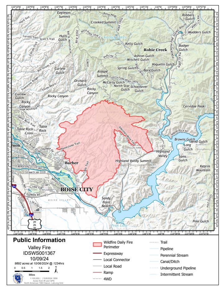
Valley Fire Update 10 09 2024
Related Incident: 2024 Valley Fire
Publication Type: News
Incident Activity: Crews gained ground on the Valley Fire thanks to light winds that favored firefighting efforts Tuesday. Crews remain focused on the most active area of the fire in the north and northeast portion where the fire is burning in timber with smoke visible in the Robie Creek community. Dozers continue to work on indirect containment line today while hotshot crews further establish direct line close to the fire edge. Extinguishing hot spots and securing the fire edge is a priority as strong winds are anticipated. Fire containment has been successful on the south and west portions of the fire visible from Boise. Those areas remain carefully monitored. The fire is under the jurisdiction of the Idaho Department of Lands and is a full fire suppression effort.
Weather: Wind gusts could reach around 20 miles per hour over the Valley Fire Wednesday and could impact fire behavior. Temperatures continue to be near 80 and fire fuels remain very dry and receptive to fire. Rain is not expected until next week.
Evacuations and Closures: No primary residences have been lost. The Robie Creek area is still in a "Ready" or Stage 1 evacuation status. Visit https://www.facebook.com/boisecountysheriff for updates. There is a Boise National Forest Valley Fire Area, Road and Trail Closure. Visit https://www.fs.usda.gov/alerts/boise/alerts-notices or contact the Mountain Home Ranger District at 208-587-7961. Idaho Department of Parks and Recreation has an interactive map that shows trails impacted by the Valley Fire. Visit https://arcg.is/10maj91
Valley Fire Overview: The fire was reported Friday, October 4, 2024, about 1 mile east of Boise on the north side of Idaho State Highway 21. The fire was very visible from East Boise as it burned in mostly grassy fuels in the Boise Foothills. Quick work on initial attack stopped the fire from reaching nearby homes. The Bureau of Land Management, Boise District, along with the Boise Fire Department and other local agencies led initial firefighting efforts. Resources include hotshot crews, engines, dozers, and aerial resources. No injuries have been reported.
Safety Message:
Avoid burning during windy conditions. Wind can cause embers to spread quickly, igniting dry vegetation.
Wind increases the risk of fire-damaged trees falling. Please avoid fire-impacted areas when recreating. Public and firefighter safety are the top priorities.
Honor closure areas. Closures are carefully considered due to fire damage, erosion, or firefighting activities.
Dollar PostFire BAER Soil Burn Severity Map Released 10 09 2024
Related Incident: Boise NF Post-Fire BAER 2024
Publication Type: News
Dollar Post-Fire BAER Soil Burn Severity Map Released
October 8, 2024
USDA Forest Service Burned Area Emergency Response (BAER) specialists recently completed their data gathering and analysis for the Dollar Fire burned area to produce a post-fire Soil Burn Severity (SBS) map.
The BAER assessment team used initial remote sensing imagery with their field-validated soils data, to develop and produce a map showing soil burn severity levels for the burned area. The SBS is broken into four different classes: unburned/very low (green), low (blue), moderate (yellow), and high (red). For more information on these different SBS classifications, see the BAER Information Brief at: Idbof Boise Nf Postfire Baer 2024 - | InciWeb (wildfire.gov).
The BAER SBS map and data display categories of unburned/very low, low, moderate, and high soil burn severity in different colors for the different categories. Approximately 84% of the 4,461 acres analyzed by the BAER team are either unburned/very low or low soil burn severity, while 14% sustained a moderate soil burn severity, and about 2% were identified as having high soil burn severity.
There are several types of fire severity and intensity maps that you may see. Although the maps look different for the same fire, they are accurate. This is because fire severity or intensity are different metrics of the fire effects on a specific resource such as soils, tree canopies, vegetation or wildlife habitat. Burned Area Emergency Response (BAER) maps are primarily measures of fire effects on soils. See also Fire Intensity vs. Soil Severity Effects BAER Information Brief at: Idbof Boise Nf Postfire Baer 2024 - | InciWeb (wildfire.gov).
The BAER team relies on their final soil burn severity map to produce data, which they are using in their subsequent modeling and determination of post-fire runoff, erosion, and sedimentation. The BAER team, and the US Geological Survey (USGS) utilize the soil burn severity map as an analysis tool to estimate post-fire watershed response to precipitation events. In specific areas that experienced moderate to high burn severity, there could be increased runoff from steep hillslopes which could result in increases of post-fire soil erosion, sedimentation, and potential debris flows.
The Dollar Fire SBS map can be downloaded at the Boise NF Post-Fire BAER 2024 InciWeb site: Idbof Boise Nf Postfire Baer 2024 Information | InciWeb (wildfire.gov) under the “Maps” tab.
BAER SAFETY MESSAGE: Everyone near and downstream from the burned areas should remain alert and stay updated on weather conditions that may result in heavy rains and increased water runoff. Flash flooding may occur quickly during heavy rain events--be prepared to act. Current weather and emergency notifications can be found at the National Weather Service website: www.weather.gov/boi/.
###
Snag PostFire BAER Soil Burn Severity Map Released 10 09 2024
Related Incident: Boise NF Post-Fire BAER 2024
Publication Type: News
Snag Post-Fire BAER Soil Burn Severity Map Released
October 8, 2024
USDA Forest Service Burned Area Emergency Response (BAER) specialists recently completed their data gathering and analysis for the Snag Fire burned area to produce a post-fire Soil Burn Severity (SBS) map.
The BAER assessment team used initial remote sensing imagery with their field-validated soils data, to develop and produce a map showing soil burn severity levels for the burned area. The SBS is broken into four different classes: unburned/very low (green), low (blue), moderate (yellow), and high (red). For more information on these different SBS classifications, see the BAER Information Brief at: Idbof Boise Nf Postfire Baer 2024 - | InciWeb (wildfire.gov).
The BAER SBS map and data display categories of unburned/very low, low, moderate, and high soil burn severity in different colors for the different categories. Approximately 67% of the 33,335 acres analyzed by the BAER team are either unburned/very low or low soil burn severity, while 28% sustained a moderate soil burn severity, and about 5% were identified as having high soil burn severity.
There are several types of fire severity and intensity maps that you may see. Although the maps look different for the same fire, they are accurate. This is because fire severity or intensity are different metrics of the fire effects on a specific resource such as soils, tree canopies, vegetation or wildlife habitat. Burned Area Emergency Response (BAER) maps are primarily measures of fire effects on soils. See also Fire Intensity vs. Soil Severity Effects BAER Information Brief at: Idbof Boise Nf Postfire Baer 2024 - | InciWeb (wildfire.gov).
The BAER team relies on their final soil burn severity map to produce data, which they are using in their subsequent modeling and determination of post-fire runoff, erosion, and sedimentation. The BAER team, and the US Geological Survey (USGS) utilize the soil burn severity map as an analysis tool to estimate post-fire watershed response to precipitation events. In specific areas that experienced moderate to high burn severity, there could be increased runoff from steep hillslopes which could result in increases of post-fire soil erosion, sedimentation, and potential debris flows.
The Snag Fire SBS map can be downloaded at the Boise NF Post-Fire BAER 2024 InciWeb site: Idbof Boise Nf Postfire Baer 2024 Information | InciWeb (wildfire.gov) under the “Maps” tab.
BAER SAFETY MESSAGE: Everyone near and downstream from the burned areas should remain alert and stay updated on weather conditions that may result in heavy rains and increased water runoff. Flash flooding may occur quickly during heavy rain events--be prepared to act. Current weather and emergency notifications can be found at the National Weather Service website: www.weather.gov/boi/.
###
Middle Fork Complex Update Oct 9th 2024 10 09 2024
Related Incident:
Publication Type: News
Middle Fork Complex Fire Update
October 9, 2024
Middle Fork Complex Fire Information: 208-992-3045 (8 a.m. - 8 p.m.)
Email: 2024.middleforkcomplex@firenet.gov
Middle Fork Complex: 61,495 acres, 90% completed, 138 personnel
Snag Fire: 33,437 acres, 90% completed, 26 personnel
Goat Fire: 33,450 acres, 24% completion, 211 personnel
Weather for today is expected to remain warm and dry with winds from the southwest. There is a possibility of gusts up to 25mph or more in the fire areas. The forecast for Thursday and Friday is to be a little cooler.
On the southeast flank of the Goat Fire, firefighters will continue conducting a burnout operation to reduce fuels between the fire and the contingency line near Silver and Bridge Creeks. The operations have been very successful. Firefighters will continue working in this area today, weather permitting.
On the northeast end of the Goat Fire, firefighters have built several layers of contingency line and have strategically located hose and pump equipment that can be quickly put to use if fire activity starts to move closer to the Warm Lake community. The Goat fire behavior remains to be mainly flanking and backing with limited tree torching and little short-range spotting. Firefighters are continuing to assess structure protection needs for values at risk in the Warm Lake area as well as the Silver Creek area.
On the Snag Fire, fire activity yesterday was minimal. Crews are working to evaluate the northern most part of the burn area to be sure there aren’t any areas of activity that need to be addressed. Because of the difficult terrain in that area, much of that work must be performed by hiking the perimeter and will be ongoing for the next few days. Aircrew flying over the area have reported seeing little to no visible activity.
In the Middle Fork Complex, a few isolated hot spots saw increased activity in the middle of the burn area, but activity along the perimeter remained relatively low. The potential remains for some areas that still hold heat to become more active with surface fire and isolated torching especially from wind gusts. Firefighters assigned there are closely monitoring the area and are ready to respond should that occur.
Night shift crews continue to patrol and monitor the fire areas, watching for any increases in fire activity.
Closures: The Boise National Forest has issued a revised Area, Road, and Trail Closure Order for the Middle Fork Complex, and Snag and Goat fires. The newly revised closure order and map can be found at the following link:
https://www.fs.usda.gov/alerts/boise/alerts-notices.
Please check the Valley County Idaho Facebook page for any updates on evacuation readiness level changes. Residents are encouraged to sign up for Code Red Emergency Alerts to stay informed. For any questions or updates on evacuation readiness, please contact the Valley County Dispatch Center at 208-382-5160. Currently, Warm Lake Road remains open for travel without restrictions.
###
Operations Update October 8 2024 10 08 2024
Related Incident:
Publication Type: Announcement
Rail Ridge Evacuation Notice 10 09 2024
Related Incident:
Publication Type: Announcement
Due to an increase in fire activity on the Northwest side of the fire this afternoon, Wheeler County has increased their evacuation levels.
For current evacuation levels on the Rail Ridge Fire use RAPTOR (Real-Time Assessment and Planning Tool for Oregon)
Prescribed Fire Update Ignitions Nearly Finished on One Project and Begin on Another 10 09 2024
Related Incident:
Publication Type: News
After nearly completing ignitions today on the 2,365-acre Sotano Prescribed Fire to the north of El Rito (Rio Arriba County), fire crews are close to wrapping up a major step on the project. They plan to finish treatment on the remaining 115 acres tomorrow, when smoke production will be minimal compared to the last two days.
On the other side of the forest, near Angel Fire, crews took a methodical approach as they began ignitions on the La Jara and Apache Prescribed Fire, where 100 acres were treated directly adjacent to the Taos Pines community.
“With this part of the unit directly next to homes, we’re going low and slow,” said District Ranger Michael Lujan. “We plan to continue ignitions along the neighborhood boundary on Wednesday.”
Teamwork
Partnerships are key to completing this work. Carson National Forest crews were joined today by personnel from State of N.M., Bureau of Land Management and U.S. Fish and Wildlife Service on the Sotano Prescribed Fire and Taos County, Taos Pueblo, State of N.M. and Latir Volunteer Fire Department on the La Jara and Apache project.
Drones
Personnel also used uncrewed aerial systems, or drones, outfitted with infrared sensors to monitor both prescribed fires by air. Operators use infrared to see heat signatures and focus on the edges of the prescribed fire to identify any spot fires that slopped over control lines.
Smoke and Community Notifications
Prescribed fire treatments will produce smoke that can drift near and far from project sites. Fire managers coordinate with the New Mexico Environment Department to conduct ignitions on days when smoke impacts are minimized.
Unlike large wildfires, prescribed fires are short-term in duration and planned with advance notice. Residents and visitors are encouraged to keep updated with prescribed fire and other Carson National Forest news by joining the forest news release list, among other options like following on social media and using NMFireInfo.com.
More information about prescribed fires, including smoke-readiness tips, are available online.