
Railroad Daly Fire Update October 10 2024 10 10 2024
Related Incident:
Publication Type: News
Type 3 Incident Command Team, Incident Commander Matt Young
Location: From the Bitterroot NF: Railroad Creek/ Skalkaho Creek confluence, 26 miles southeast of Hamilton
From the Beaverhead-Deerlodge NF: 20 Miles northwest of Georgetown Lake Dam off Skalkaho Hwy
Start Date: 7/25/2024
Cause: Undetermined
Daly Fire Acres: 9,161 Railroad Fire Acres: 1,429 Completion: 56%
Total Personnel: 182
Current Status
Yesterday the fire showed an increase in acres with active uphill runs, single tree torching and short-range spotting. The fire was very active near the Skalkaho Falls and continued progression towards Dam Lake. Helicopters and Air Tankers were utilized to preform water and retardant drops in support of constructing control features.
In Daly Creek area, fire crews will work towards keeping the fire South of Gird Ridge, North of Hwy 38, East of FS Rd #75 as well as east of private property on the north side of Hwy 38. Today crews will prepare for additional structure protection in the Stoney creek drainage, Cornish Gulch and along the west side of the Rock Creek corridor in efforts to minimize impacts of wildfire to private lands.
Weather and Fire Behavior
Cooler temperatures along with higher relative humidity is expected today. There is an increase in cloud cover and a slight chance for rain showers today; however little to any precipitation is expected.
Fire activity and potential will remain high in the near future due to current and forecasted weather. In the West, burn periods will be longer than usual, especially during wind events. Other areas are likely to see increased fire potential as leaf fall rises, with little precipitation expected. Anomalously dry conditions in the West will heighten fire activity in October, with significant fire behavior during wind events potentially resembling August's intensity, including long burn periods.
EVACUATIONS
Ravalli County Sheriff Steve Holton said Evacuation Warnings have been issued for residents of the 1700 to 2500 blocks of Skalkaho Highway due to the Railroad-Daly Fire on October 9, 2024. For more information on evacuations visit the Ravalli County Sheriff Facebook page. To register your phone number for emergency notifications in Ravalli County visit, http://hyper-reach.com/mtravallisignup.html.
CLOSURES
Montana Department of Transportation has closed Highway 38 at mile marker 14 to mile marker 26 due to fire activity.
The Beaverhead-Deerlodge National Forest has issued an Area/Road/Trail Closure (Closure #01020824-19) effective October 4, 2024. This Order is for public and firefighter safety during fire suppression efforts of the Fire. Closure information and maps are posted on the Bitterroot and Beaverhead-Deerlodge National Forests’ website www.fs.usda.gov/alerts/bdnf/alerts-notices and www.fs.usda.gov/alerts/bitterroot/alerts-notices.
Rail Ridge Daily Update 10 10 2024
Related Incident:
Publication Type: Announcement
Rail Ridge Fire Update
October 10, 2024
Central Oregon Wildfire Information: centraloregonfire.org
Email: 2024.railridge@firenet.gov – Phone: 541-208-7111
Social Media, Evacuation and Closure Information: https://linktr.ee/RailRidgeFire
Acres: 173,530 – Containment: 89% – Detection: 09/02/24 – Cause: Lightning – Personnel: 575
Operational Update – Yesterday, the moderated weather over the Rail Ridge Fire area was a welcome change for firefighters. Increased humidity, lower temperatures, and increased cloud coverage limited the overall fire activity. The moderated weather provided the opportunity for the tactical burning on the western containment line of the Black Canyon Wilderness to be completed. Last night firefighters used an Unmanned Aircraft System (UAS) with Plastic Sphere Dispensers (PSD) for aerial ignition operations. Lighting the unburned fuel pockets within the containment lines of the fire, much like a prescribed fire. Managing when and how these unburned pockets of fuels burn is a beneficial tactic used to control the severity that may occur if they were to burn uncontrolled.
The spot fire on the northwestern edge of the fire is currently estimated to be around 1600 acres and grew very little yesterday. The southern portion has burned into the main fires edge and firefighters scouted for opportunities for containment lines using existing roads, trail systems and natural barriers. Air tankers were utilized to protect values at risk and helicopters supported ground resources with water bucket drops.
Today, crews will continue to work diligently on the northwest section of the fire and aviation resources will continue to be used as needed. Facing very heavy fuel loads and rugged terrain in this area, equipment has been ordered to prepare containment lines using roadways and natural barriers as much as possible. Opportunities to construct dozer line or handline adjacent to the fires edge will be used if it is safe to do so. Fire activity is expected to be similar to yesterday, with decreased fire behavior due to increased cloud cover, better humidity recovery overnight, and decreased winds. Crews will continue to mop-up and strengthen the containment lines that were blacklined yesterday around the western side of the wilderness. The Unmanned Aircraft System (UAS) is available to continue lighting the unburned fuel pockets within the containment lines of the fire if needed. Suppression repair continues across the fire area, the fire team continues to work with landowners and local agency administrators to find what suppression repair remains to be accomplished.
Weather – Cooler temperatures in the low 60s are expected over the region today with light terrain driven winds. Minimum relative humidity this afternoon will be in the mid to upper 30% range and strong humidity recovery is again expected over night at around 60%.
Forest & BLM Closures / Evacuation Information / Fire Restrictions for the Rail Ridge Fire area can be found at: https://linktr.ee/RailRidgeFire.
Fire Closure Davis Fire Update 09 17 2024
Related Incident: Davis Fire
Publication Type: Announcement
Any National Forest System lands within the Davis Fire burned area remains closed. This includes Forest Service roads 41040, 41041, and 41727, as well as the Ophir Creek Trail.
For detail information on the Davis Fire:
• Inciweb: https://inciweb.wildfire.gov/incident-information/nvhtf-davis-fire
Elk Fire Update Thursday October 10 2024 10 10 2024
Related Incident: Elk Fire 2024
Publication Type: News
Elk Fire Update – October 10, 2024
Rocky Mountain Area Complex Incident Management Team 3
Casey Cheesbrough, Incident Commander
Size: 76,378 acres (409-acre increase)
Total Personnel: 902
Containment: 15 percent
Cause: Lighting
Resources: 10 helicopters, 21 crews, 63 engines, 8 dozers, 12 water tenders, 5 masticators, 1 skidder
Key Messages: The recording of last night’s community meeting at Big Horn High School can be viewed on the Elk Fire YouTube channel (www.youtube.com/@2024ElkFire/videos) and the Bighorn National Forest’s Facebook Page (Facebook.com/bighornnf).
The percent containment reported decreased from 16 percent to 15 percent because of recent fire growth. Percent containment measures how much of the fire’s perimeter is surrounded by a control line. The perimeter of the fire is 225 miles, with 34 of those miles being contained firelines.
Overnight, the fire crossed the Big Goose River on the southern end of the fire. The night crew was ready and anticipating this forward progression. They completed firing operations to introduce low-intensity fire on the landscape to reduce the fuel load before the active fire got there. The day shift will continue to work in this area, patrolling and mopping up residual hotspots.
Current Situation:
Residents in Sheridan, Beckton, Bighorn, or Story may have noticed more fire activity and smoke yesterday. The fire was very active, particularly on the west side, due to high winds, high temperatures, low humidity. The fire is expected to be active again today, potentially producing abundant smoke. Additionally, the Rocky Mountain Incident Management Team has been implementing strategic firing operations along the northern and southern edges of the fire perimeter, consisting of adding low- to moderate-intensity fire to the ground in targeted areas to remove fuels from the fire and limit its intensity. Firing operations will continue today if weather conditions permit.
On the fire’s northern side, a hotshot crew conducted additional firing operations, and air operations dropped fire retardant yesterday off the 144 Road. Today, the crews will continue to prepare the 144 Road to protect the Little Bighorn Canyon. The established containment line along the northeastern side of the fire perimeter is holding, and there is minimal heat detected in the area.
On the southeastern and southern parts of the fire, mopup and patrolling continues. Firefighting crews will continue to build additional control lines and prepare areas for potential firing and aerial operations that would protect the watershed and associated water-treatment plant structures. Road graders are working alongside firefighting resources to prepare the Red Grade Road.
On the western side of the fire in the Burgess Junction area, structure protection is in place, and more pumps and sprinklers will be installed today. Firefighters remain on scene to protect structures and conduct defensive firing operations if needed.
Weather & Fire Behavior: A cold front is moving in today, dropping temperatures, increasing humidity, and shifting wind direction to the northwest. The shifting, gusty winds will likely increase fire activity and smoke production, particularly on the fire’s west side, directing growth into the Bighorn National Forest. Vegetation remains extremely dry and receptive to burning. The cooler, moister conditions are not expected to reduce fire behavior in areas with timber. For air-quality and smoke information, refer to the AirNow website: airnow.gov.
Evacuations and Closures: Sheridan County evacuation levels did not change Wednesday. For detailed information, view the evacuation map and all news releases on the Sheridan County Emergency Management website: tinyurl.com/2s38bcc5 or call either the Sheridan County Sheriff’s Office (307-672-3455) or Sheridan County Emergency Management (307-752-2174).
Bighorn National Forest lands around the Elk Fire are closed under Order 02-02-06-24-08. The order and map can be viewed on the forest’s alerts web page: fs.usda.gov/alerts/bighorn/alerts-notices.
US Highway 14 is closed at Granite Pass/Hunt Mountain Road/FS 10 (milepost 38.3). US Highway 14A is closed at Hunt Mountain Road/FS10 (milepost 85.6). View the Wyoming Department of Transportation road-closure map here: wyoroad.info. Sheridan County road closures have been modified. The following roads remain closed to allow fire personnel to travel the roads safely, ranchers in those areas to move cattle safely, and the residents who live in those areas to travel safely as well.
Soft Closures (roads are closed to the public except local residents):
All of Pass Creek Road to the Wyoming/Montana state line
All of Beckton Road
Slack Road at the Wyoming/Montana state line
Soldier Creek Road West from the Wolf Creek and Soldier Creek Road Intersection
Little Horn Canyon Road
Big Goose Road from the Intersection of Big Goose Road and Beckton Road
Twin Creek Road at the Parkman Access
Rapid Creek Road
Columbus Creek Road
Beckton Hall Road
Smith Creek Road
Big Horn Road
Tongue Canyon Road
Little Goose Canyon Road
Hard Closures (no public access):
All of Red Grade Road
Evacuation Shelter:
An emergency shelter has been established at the fairgrounds in Sheridan and can accommodate numerous people, campers, and animals. To plan for people or animals, call 307-752-2174 or 307-683-6965.
Elk Fire Information:
Phone: 307-303-7642 (8 am to 8 pm)
Email: 2024.Elk@firenet.gov
Linktree: linktr.ee/2024ElkFire
![]()
Middle Fork Complex Daily Update Oct 10th 2024 10 10 2024
Related Incident:
Publication Type: News
Middle Fork Complex Fire Update
October 10, 2024
Middle Fork Complex Fire Information: 208-992-3045 (8 a.m. - 8 p.m.)
Email: 2024.middleforkcomplex@firenet.gov
Middle Fork Complex: 61,495 acres, 90% completed, 137 personnel
Snag Fire: 33,437 acres, 90% completed, 24 personnel
Goat Fire: 34,595 acres, 23% completion, 255 personnel
Weather: Temperatures today are expected to be five degrees cooler than yesterday with less wind and much more cloud cover. The forecast is showing a continued cooling trend for Thursday and Friday with temperatures in the low to mid-60s and humidity in the 30% to 40% range. In addition, the models are showing reduced fire behavior. All of this is a big change in the weather pattern in a positive direction.
Goat Fire: Given the modest winds yesterday, there was no movement on the northeast section of the Goat Fire. Firefighters are continuing to work in the area near the Yellow Jacket Trail. Crews are putting in contingency and control lines to make sure the fire does not impact the residents in the Warm Lake area and will remain in the area watching for activity late into the night.
On the southeast flank of the Goat Fire, approximately 90% of the burn operations were completed yesterday. The objective was to keep the fire contained between the Silver Creek drainage and the Middle Fork Road. There is still a small section on the west side of Silver Creek that firefighters are working on finishing today. Firefighters will resume work in this area today working to complete the burnout operation and begin mop up of hot spots.
Snag Fire: The Snag Fire saw no significant activity in the past couple days. Given the rugged terrain, crews are hiking the perimeter to ensure the containment lines are holding.
Middle Fork Complex: Fire behavior on the Nellie and Bulldog is limited to creeping and smoldering with no expected growth. Fire crews will continue to patrol and monitor fire lines and mop-up as necessary as well as continue suppression repair. There is a small patch of intense heat on Nellie, southeast of Scott Mountain that had minimal growth. There is no intense or scattered heat on Bulldog near the perimeter. There is potential for some areas that still hold heat to become more active with surface fire and isolated torching.
Notice: General deer hunting season starts today. Please be aware of additional fire traffic in the area.
Closures: The Boise National Forest has issued a revised Area, Road, and Trail Closure Order for the Middle Fork Complex, and Snag and Goat fires. The newly revised closure order and map can be found at the following link: https://www.fusda.gov/alerts/boise/alerts-notices.
Please check the Valley County Idaho Facebook page for any updates on evacuation readiness level changes. Residents are encouraged to sign up for Code Red Emergency Alerts to stay informed. For any questions or updates on evacuation readiness, please contact the Valley County Dispatch Center at 208-382-5160. Currently, Warm Lake Road remains open for travel without restrictions.
###
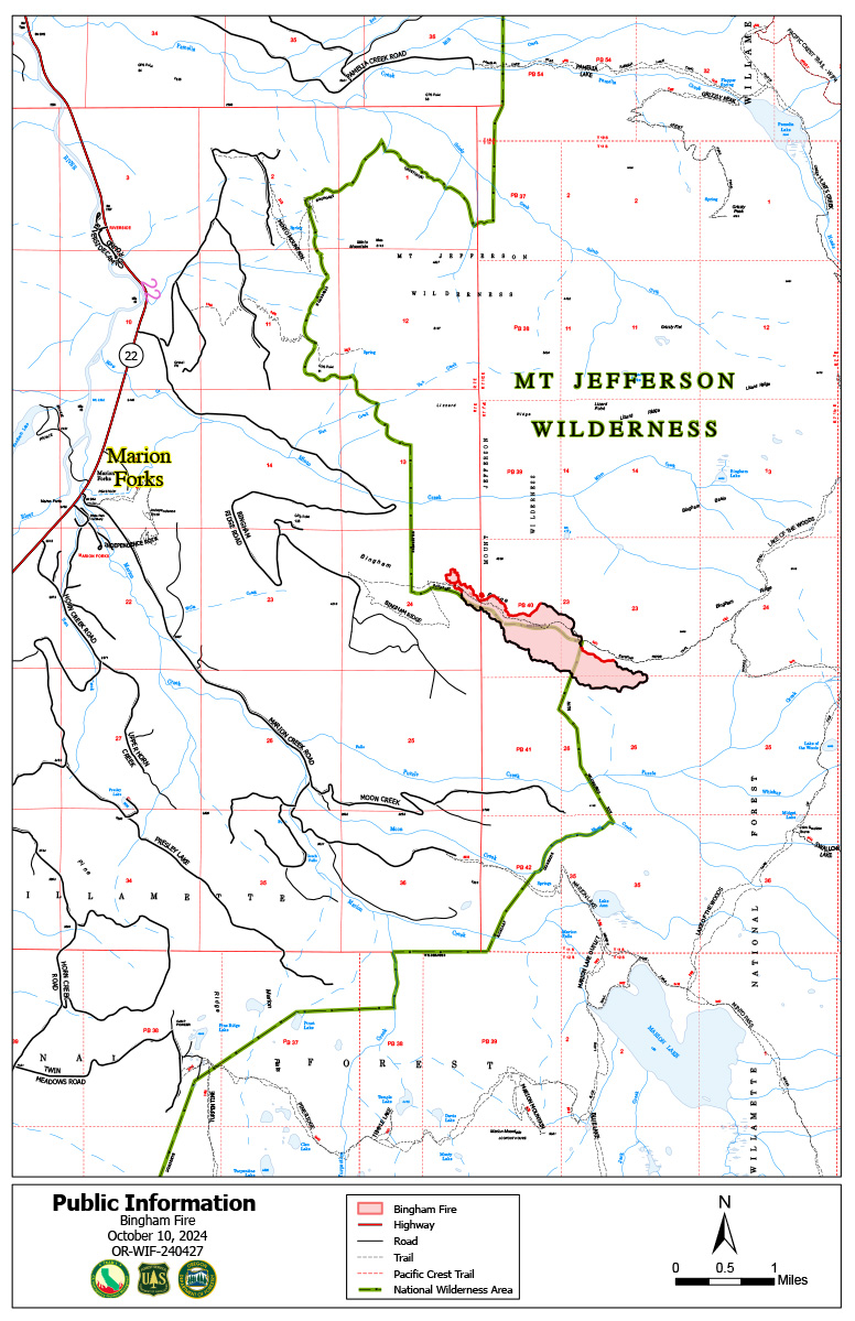
Bingham Fire Daily Update for Thursday October 10 2024 10 10 2024
Related Incident: Bingham Fire
Publication Type: News
Bingham Fire containment increases to 65%
Daily Update: October 10, 2024
Fire Information Phone: 503-854-3366 (8 a.m.-8 p.m.)
Email: 2024.Bingham@firenet.gov
Acres: 199 Containment: 65%
Location: Areas of the Mount Jefferson Wilderness, east of Marion Forks.
Start Date: September 30,2024 Personnel: 356
Resources: 12 crews | 2 engines | 1 bulldozer | 3 water tenders | 1 masticator
Highlights: Light rain fell Wednesday, Oct. 9, over the Bingham Fire as crews had another productive day on the fire line. The fire remained within its existing perimeter at 199 acres, while containment rose to 65 percent.
The delivery of portable water pumps and cooler temperatures in mid-50s to lower 60s allowed crews to extinguish a number of isolated heat sources off the perimeter, widening containment lines up to 100 feet in a number of areas. Firefighters will continue patrolling containment lines and extinguishing hot spots, while also monitoring a wind shift forecast out of the east.
Evacuations: LEVEL 3: GO NOW! Evacuation alerts have been issued by the Linn County Sheriff’s Office for a large area of the Mount Jefferson Wilderness. Additionally, LEVEL 2: GET SET evacuation alerts have been issued for the area around Marion Forks Campground and Marion Forks Fish Hatchery. The Level 2 evacuation area also extends along Highway 22, to a ½-mile west of Highway 22, from Pamelia Road (NFS Road 2246) south to Parrish Lake Road (NFS Road 2266). Please refer to the Linn County Wildfire Map for more information: https://tinyurl.com/LinnCoFireMap. Highway 22 remains open.
The Willamette National Forest issued a closure order Oct. 4 within the same footprint as the Level 3 evacuation zone. Details of the closure order can be found here: https://tinyurl.com/26jpr9a6. The Pacific Crest Trail through the Mount Jefferson Wilderness is expected to remain open. Trails and roads west of the highway are closed from Pamelia to the Big Meadows Loop/Turpentine Loop area. With hunting season started, Forest Service staff will work with the Linn County Sheriff’s Office to reduce closure areas as soon as it is safe to do so.
Weather: A forecast wind shift out of the east today will mark a change from the predominantly westerly winds that have blown since the fire’s start Sept. 30. Wind speeds are expected to be minimal—5 to 10 miles an hour—with gusts likely no greater than 15 miles an hour. Temperatures should remain in the upper 50s to lower 60s for the next few days.
GARDEN FIRE UPDATE OCTOBER 10 2024 10 10 2024
Related Incident:
Publication Type: News
https://inciweb.wildfire.gov/incident-information/idscf-garden-fire
Date of Detection: September 8, 2024
Fire Size: 9,533 acres
Completion: 0%
Cause: lightning
Location: approximately two (2) miles southwest of the confluence of Panther Creek and the Main Salmon River on the North Fork Ranger District in the Frank Church River of No Return Wilderness.
Fuels: grass, brush, dead and down fuels, and timber
Resources: 177 people
Engines: 14
Type I Helicopters: 1
Type I Crew: 1
Type II Crew :4
Special Notes: The Salmon River Road and the Salmon River to float boating will remain open. NO stopping from SPRING CREEK to LONG TOM PICNIC AREA. Expect delays from the confluence of the Main Salmon River and Panther Creek and Cove Creek due to firefighting activity to allow the firefighters to do their job safely and efficiently. The Salmon River Road could be closed due to fire behavior at any time. Be prepared to stay downriver.
Current situation: Firefighter and public safety is the number one priority for the Garden Fire. Fire managers are using a combination of full suppression and a point protection strategy (a wildfire response strategy, which protects specific assets or highly valued resources from the wildfire without directly halting the continued spread of the wildfire) to minimize exposure to fire personnel while protecting identified values, including private property and Forest Service infrastructure.
The fire continues to grow in the Garden Creek drainage and to the ridge to the north, towards the Salmon River. Fire is currently holding in the upper reaches of Clear Creek; fire has backed down to Panther Creek between Bear Gulch and Clear Creek. In this area, the fire has moved into the grass and is holding. Between Lime Gulch and Garden Creek, the fire is holding in the bottom of the drainage. Small scale firing operations using an unmanned aircraft system (UAS) were used in Panther Creek to bring fire to the grass. The fire did not spot across the Salmon River.
Presence of firefighters, primarily in the Panther Creek and Salmon River areas on both a day and night shift, continues. There will be a heavy presence of firefighters along the Salmon River Road today and are ready to respond in case the fire spots over the Salmon River. Aircraft, both fixed wing and helicopters, will be used if weather and smoke conditions allow. Fire managers are continuing to look for opportunities to engage the fire direct as fuels and weather conditions change and it is safe to do so.
Evacuations: Lemhi County Law Enforcement, Emergency Management, and the Salmon-Challis National Forest have established three (3) evacuation zones for the Garden Fire.
Zone 1: From Cove Creek to Ebeneezer Bar, downriver along the Salmon River Road #030.
Zone 2: On Panther Creek Rd #055, a half mile south of Beaver Creek Rd #057 to the Salmon River Rd #030 confluence.
Zone 3: Panther Creek to Spring Creek to include private land up Spring Creek
- ZONE 1 is in “GO” status
- ZONE 2 is in “GO” status
- ZONE 3 IS IN "SET" STATUS
Information on evacuation status can be found on Lemhi County’s website, https://www.lemhicountyidaho.org/, under ‘News and Notices.’
Weather: Dry and seasonably warm conditions with light winds will continue into early next week under the persistent influence of high pressure overhead. Long-range models continue to indicate a pattern change starting midweek next week with increasing chances of precipitation and a return to seasonably cool temperatures.
Closures: There are two closures associated with the Garden Fire. The Red Rock/Black Eagle and Garden Fire Closure #004-13-24-024 and the Garden Fire Closure #04-13-24-025 can be found at on the Salmon-Challis National Forest Website at https://www.fs.usda.gov/alerts/scnf/alerts-notices. Closure #04-13-24-025 was put in place due to fire behavior and current and predicted weather, with these conditions, the Garden Fire has the potential to spot across the Salmon River to the north. If the fire spots across the river, with current fuel conditions and predicted winds, the fire has a potential to make a large run.
Visit our website at: www.fs.usda.gov/scnf/, ‘Like Us’ on Facebook @salmonchallisnf, and ‘Follow Us’ on X @salmonchallisnf.
####
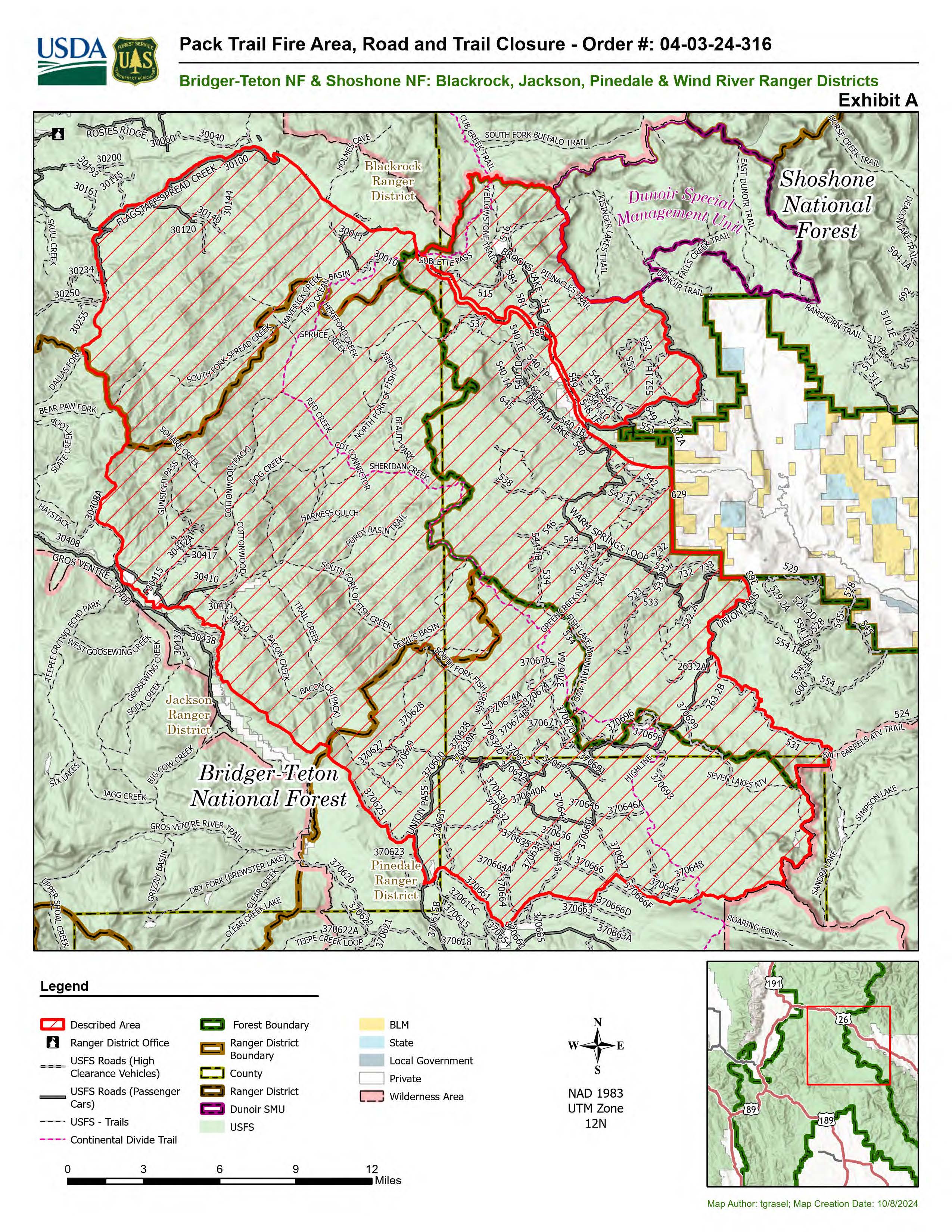
Pack Trail Daily Update October 10 2024 10 10 2024
Related Incident:
Publication Type: News
Pack Trail Daily Update October 10, 2024
Total Acres: 67,376 Confined: 60%
Total Personnel: 571
Community Meeting TODAY, October 10, 2024 at 6 P.M. at Museum of Military Vehicles in Dubois
Operations – Yesterday, the Pack Trail Fire pushed into the area of Cowboy Camp, Strawberry Warming Hut and Fish Creek Guard Station near Union Pass Road. In addition to the sprinklers already in the area, retardant was dropped from aircraft to protect structures and slow the fire’s spread. Today crews will continue to build primary and secondary holding lines near the 553 road, and scout for natural and indirect holding features. The west side continues to slowly back down Burnt Ridge. Firefighters continue to install structure protection at Elk Track Ranch and in the Gros Ventre area. On the east side, firefighters reported calm fire behavior overnight. They continue to clean up and cool down the successful small tactical firing operation completed to protect the 540 road. Sprinklers and structure protection continue to be implemented in the Long Valley, Teton Youth Camp and Union Pass Subdivision areas. On the north side, there was no new fire activity, but some heat remains in the interior and smoke may be visible. Crews continue to patrol the area checking for new smoke and growth.
Safety - Drivers on US-26 may experience periods of smoke today due to high winds. Please use caution while driving, use headlights, and expect to encounter fire vehicles along the road. If planning travel on US-26 across the Continental Divide monitor WY-DOT for possible closures due to fire activity.
Teton Interagency Fire managers are maintaining the Very High Fire Danger Rating for Grand Teton National Park, the Bridger-Teton National Forest, and the National Elk Refuge. Due to excessively dry fuels, any spark can ignite fire which can spread rapidly, becoming a large fire and exhibit extreme fire intensity. Residents and visitors are urged to exercise extreme caution with fire or possible ignition sources. Always build your campfires away from dry grass, leaves, and overhanging branches to reduce the risk of spreading wildfire. Clear at least a 10-foot perimeter around your fire, removing any flammable material, and make sure your fire is dead out and cool to touch before you go to sleep, or leave the area.
Weather – Last night the winds were calm, humidity recovered to 70% and the temperature was between 30-43 degrees. Today will be smoky, partly cloudy, and windy with wind gusts up to 32 MPH. Temperature in the mid 60s, humidity 19-24% and wind speeds from 10-14MPH from the west/southwest. To learn more about air quality, visit Fire.AirNow.Gov.
Road Closures – Union Pass Road is closed from 531 Road to 370625 Road for firefighter safety.
Evacuations – The Upper Gros Ventre area (Goosewing and Elk Track Ranches) in Teton County have been put into a Level 2 “Set” Evacuation Warning. Evacuations and evacuation alerts for several subdivisions and ranches in Fremont County, WY remain in place. See the Fremont County Emergency Management Facebook Page for alerts and updates. See the Teton County Emergency Management website updates and to sign up for emergency alerts through Everbridge.
Forest Closures - Closure Order #04-03-24-316 is in effect from October 9, 2024 at 12:00 p.m. through November 1, 2024 at 6:00 a.m. unless rescinded. This order supersedes previous orders, including #04-03-24-315, prohibiting the same or similar acts in the same described area.
For more information, visit: Facebook: USDA Forest Service - Bridger-Teton National Forest, USDA Forest Service - Shoshone National Forest Pack Trail Inciweb: https://inciweb.wildfire.gov/incident-information/wybtf-pack-trail-fire
Red Rock Fire Daily Update 10 10 2024
Related Incident:
Publication Type: News
New start – Napias Fire
Highlights: A new fire was detected northeast of the Red Rock Fire, fire behavior is anticipated to moderate today.
Operations: Red flag conditions yesterday continued to challenge firefighters. While there continued to be little fire growth on the west side in the Wilderness, other areas of the fire remained active. On the north side engines continued providing point protection and installing watering systems around Colbalt. On the south end, dozer line was reinforced near Moyer. A new fire start was discovered northeast of the Red Rock Fire in Napias Creek. Firefighters and aircraft responded until increased winds made it too dangerous for aircraft to fly in the late afternoon. The fire was last estimated to be around 15 acres.
Today dozers and equipment will continue to scout containment line placement on the east side heading south. Crews will also be securing and improving lines in Fourth of July Creek on the south side. Engines will finish installing sprinkler systems in Colbalt and other areas on the north side. As aircraft is able, it will be used to address the new fire in Napias Creek.
Weather: A weak disturbance is moved through ridge that has been over the fire bringing an increase in the gusty winds today. The afternoon winds at Ridge Rock Peak were southwest 10 to 13 mph with gusts 24 mph to 30 mph. Temperatures again climbed to the mid-60s, and the humidity dipped down below 20%. The system will bring in more clouds and Thursday looks to be one of the first mostly cloudy days so far this month. No precipitation is anticipated with this system as it makes it way through the area this weekend. Thursday look to be cooler with highs in the upper 50s and humidity in the 30-38% range. Winds are predicted to be out of the southwest at 8 mph with gusts to 19 mph.
Smoke: A smoke outlook is available for the area of the Red Rock Fire.
Closures: The forest closure order was updated and expanded October 5, 2024.
Evacuations: Go evacuation orders are currently in place for Zones 1 through 5. Ready evacuation notice in place for US-93 corridor from Williams Creek to Elk Bend (Zone 6).
If the fire becomes established on the east side of the Ridge Road, Williams Lake and the west side of the Salmon River will advance to evacuation level Set.
Evacuation information in Lemhi County.
Safety: Please stay out of the fire area. There is still active fire behavior in the fire area, including group torching and crown runs. There are multiple roads and bridges that have been destroyed or are impassable. Entry into evacuation zones that are in “Go” status is prohibited. The updated forest closure notice that encompasses both the Red Rock Fire and Garden Fire areas includes multiple road and area closures. Barricade closures will be posted at road intersections and forest boundaries.
Line Fire Daily Update for 10 10 2024
Related Incident: Line Fire
Publication Type: News
Location: San Bernardino County, CA Start Date: September 5, 2024
Size: 43,978 acres Percent Contained: 93%
Cause: Human Personnel: 942
As of 7:00 AM, California Interagency Incident Management Team 4 has taken command of the Line Fire, and Team 11 is returning home.
CURRENT SITUATION:
Yesterday, the fire experienced a wind test greater than the days prior, and all lines held well. Firefighters continued to reinforce containment lines and utilized aircraft where appropriate to address interior hotspots.
In addition, crews continued to monitor, backhaul equipment, implement the suppression repair plan.
Today, crews will continue suppression repair on both the north and south of the incident. On the west side of the fire, patrol and mop up will continue. To the north, firefighters will construct direct line on the fire’s edge where possible and continue to monitor the area in Bear Creek as well as Siberia Creek to ensure it stays within the current footprint. On the east side, crews will continue to patrol and mop up and backhaul excess equipment. In the southeastern area, firefighters will continue to patrol and mop up and monitor any hotspot within the fire perimeter.
WEATHER:
Mainly high clouds will begin to move over the Line Fire today and continue to increase through the day Friday. High temperatures today will be similar to yesterday, before falling another 5 degrees by Saturday. Even so, temperatures will remain well above normal for this time of year. The gradual cooling will continue through early next week. We will only experience very slow improvements to relative humidity, remaining low during the day with only poor to moderate recoveries at night. After another breezy afternoon today, winds will start to weaken Saturday and Sunday.
CLOSURES:
The forest has issued a closure order in the area of the Line Fire; To view the closure order and map of closure area visit the following link https://www.fs.usda.gov/detail/sbnf/?cid=FSEPRD1181411.
Highway 330 remains closed from Highland Avenue to Highway 18 as Caltrans performs repairs to the road and guardrails.
EVACUATIONS:
Evacuation warnings remain in place for the Barton Flats, Pinezanita, and Seven Oaks communities. For current updates on evacuations, visit https://www.facebook.com/sbcountysheriff.