
Lemhi County Adds an Additional Evacuation Zone for the Garden Fire 10 09 2024
Related Incident:
Publication Type: Announcement
Zone 3 has been added
Zone 1: From Cove Creek to Ebeneezer Bar, downriver along the Salmon River Road #030.
Zone 2: On Panther Creek Rd #055, a half mile south of Beaver Creek Rd #057 to the Salmon River Rd #030 confluence.
Zone 3: Panther Creek to Spring Creek to include private land up Spring Creek
ZONE 1 AND 2 ARE IN "GO" STATUS
ZONE 3 IS IN "READY" STATUS
Lemhi County Adjusts Evacuation Zone Status 10 09 2024
Related Incident:
Publication Type: Announcement
ZONE 3 had been moved to "SET" status
ZONES 1 and 2 remain in "GO" status
Zone 1: From Cove Creek to Ebeneezer Bar, downriver along the Salmon River Road #030.
Zone 2: On Panther Creek Rd #055, a half mile south of Beaver Creek Rd #057 to the Salmon River Rd #030 confluence.
Zone 3: Panther Creek to Spring Creek to include private land up Spring Creek
_0.jpg?VersionId=cw8ZUBIFYsTyuQUD82XeGPv0WGziiUd9)
RailroadDaly Fire Evacuation Notices 10 09 2024
Related Incident:
Publication Type: Announcement
Ravalli County Sheriff Steve Holton said Evacuation Warnings have been issued for residents of the 1700 to 2500 blocks of Skalkaho Highway due to the Railroad-Daly Fire. The warnings were issued after consultation with the Darby-Sula Ranger District of the Bitterroot National Forest. Sheriff Holton said the warnings are given in an abundance of caution with a wind event and weather conditions forecast over the next several days.
Residents in an evacuation warning status should prepare to evacuate, but no evacuation orders have been issued at this time. Residents should locate important paperwork, medications and possessions, and locations to move livestock should evacuations become necessary. People with health problems or mobility issues should consider evacuating during the warning phase.
Information will be posted on the Ravalli County Sheriff's app for smart devices as it becomes available, as well as the Ravalli County Sheriff and Discover the Bitterroot Facebook pages.
Using drones on wildfires 10 09 2024
Related Incident:
Publication Type: Announcement
A short video talking about why drones increase firefighter safety on wildfires by reducing exposure to ground personnel.
https://youtu.be/8OSwnRpnPck
RailroadDaly Fires Daily Update 10 09 2024
Related Incident:
Publication Type: News
Fire Information: 406-360-4587
2024.dalyrailroad@firenet.gov
https://linktr.ee/sharrottjohnsondalyrailroad
Type 3 Incident Command Team, Incident Commander Matt Young
Location: Railroad Creek/ Skalkaho Creek confluence, 26 miles southeast of Hamilton
Start Date: 7/25/2024
Cause: Undetermined
Daly Fire Acres: 8,377 Railroad Fire Acres: 1,300 Completion: 56%
Total Personnel: 175
Current Status
Yesterday’s fire progression showed minimal growth to the east; however, the fire was active and progressed to the north in the Skalkaho Falls area towards Dam Lake. In Daly Creek, the fire continued progressing down drainage below Gird. Helicopters and Air Tankers were utilized to preform drops in support of constructing control features.
Crews will continue to establish a shaded fuel break along Coal Creek Road and will continue progressing to the Stony Creek area. Structure protection will be enhanced in Stony Creek and crews will closely monitor fire activity in the upper Stony Creek area. Crews will continue constructing and improving hand and dozer lines from Gird Creek Road to Highway 38. Aerial resources will remain actively engaged.
Weather and Fire Behavior
Near critical fire weather conditions are anticipated this afternoon. A warming trend is expected to continue today accompanied by low humidity and wind gusts of 25-35 mph.
Fire activity and potential will remain high in the near future due to current and forecasted weather. In the West, burn periods will be longer than usual, especially during wind events. Other areas are likely to see increased fire potential as leaf fall rises, with little precipitation expected. Anomalously dry conditions in the West will heighten fire activity in October, with significant fire behavior during wind events potentially resembling August's intensity, including long burn periods.
Closures
All areas along State Highway 38 (Skalkaho Highway) beginning at the top of Skalkaho Pass near mile marker 26.5 along State Hwy 38 to the East and turning to the north at the junction of State Hwy 38 and Rock Creek Road. From State Highway 38 and Rock Creek Road (County Road 102) turning north to the junction of State Highway 348 and Rock Creek Road and proceeding northwesterly on Rock Creek Road (County Road 102) to the junction of USFS Road 241. Following USFS Road 241 (Stony Creek Road) moving southwesterly to the junction of Little Stony Creek and Stony Creek. Following Little Stony Creek west to the ridge where Trail 313 (Bitterroot Rock Creek Divide Trail) begins and continuing south along Trail 313 to the intersection and ending at mile marker 14 on western side of State Highway 38.
Elkhorn Fire Update 10 09 2024
Related Incident: Elkhorn Fire
Publication Type: News
Elkhorn Fire Update – October 9, 2024
We are working to produce an updated map that shows containment and acreage. It will be shared as soon as it is finalized.
Firefighters are working to continue towards an increased containment of the fire with the anticipation of a cold front arriving on Thursday. The cold front may bring 12 to 16mph winds with gusts around 23mph. Additional resources have arrived to assist with the fire today. We would like to thank all the local, federal, and state agencies that have supported this effort.
Yesterday, the USDA Forest Service Dakota Prairie Grasslands issued a National Forest System Area and Roads closure order for affected areas by the Elkhorn Fire; effective immediately to protect public health and safety. The full closure can be found at https://www.fs.usda.gov/alerts/dpg/alerts-notices/?aid=91424 This closure order will remain in effect through December 31, 2024, or until rescinded.
Most of the smoke from the Elkhorn Fire is coming from woody interior draws. While smoke may have not been prominent over the last two days, the fire is still active and ongoing. If you see smoke is coming from within the fire area, please do not report it.
NDResponse has shared Wildfire Recovery Resources for those who have been impacted. Please visit Wildfire Recovery | ND Response to learn more.
Community Radio Interview with Incident Meteorologist 10 09 2024
Related Incident:
Publication Type: Announcement
Watch highlights of an interview with Incident Meteorologist Ryan Leach on YouTube:
https://youtu.be/xQ-i8PE0df4?si=SsxlFqLOL96890xW
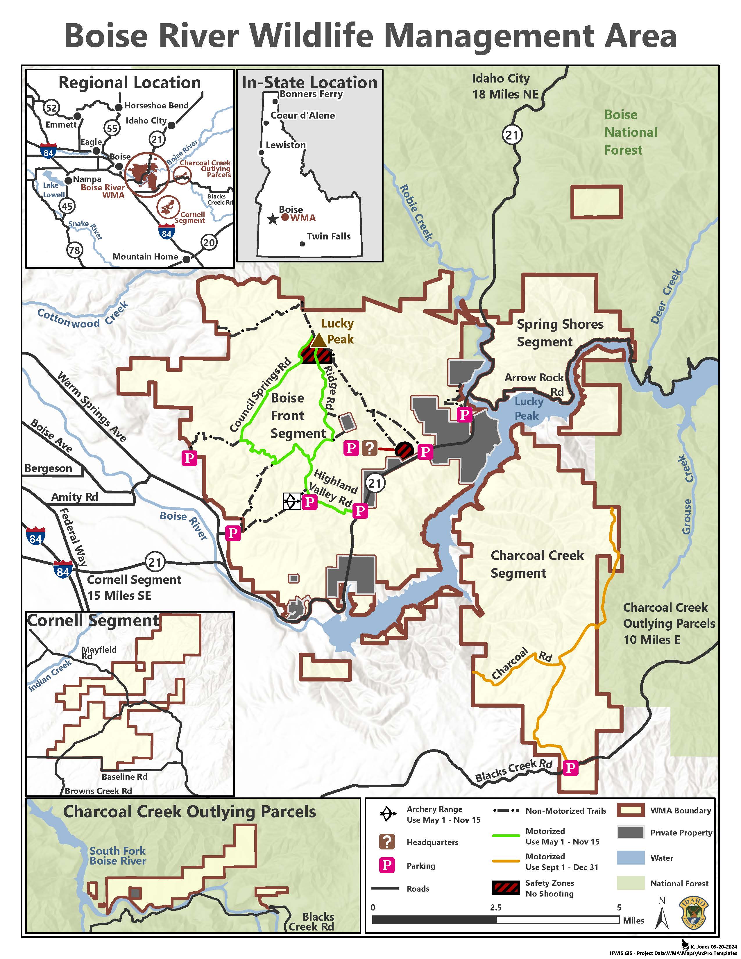
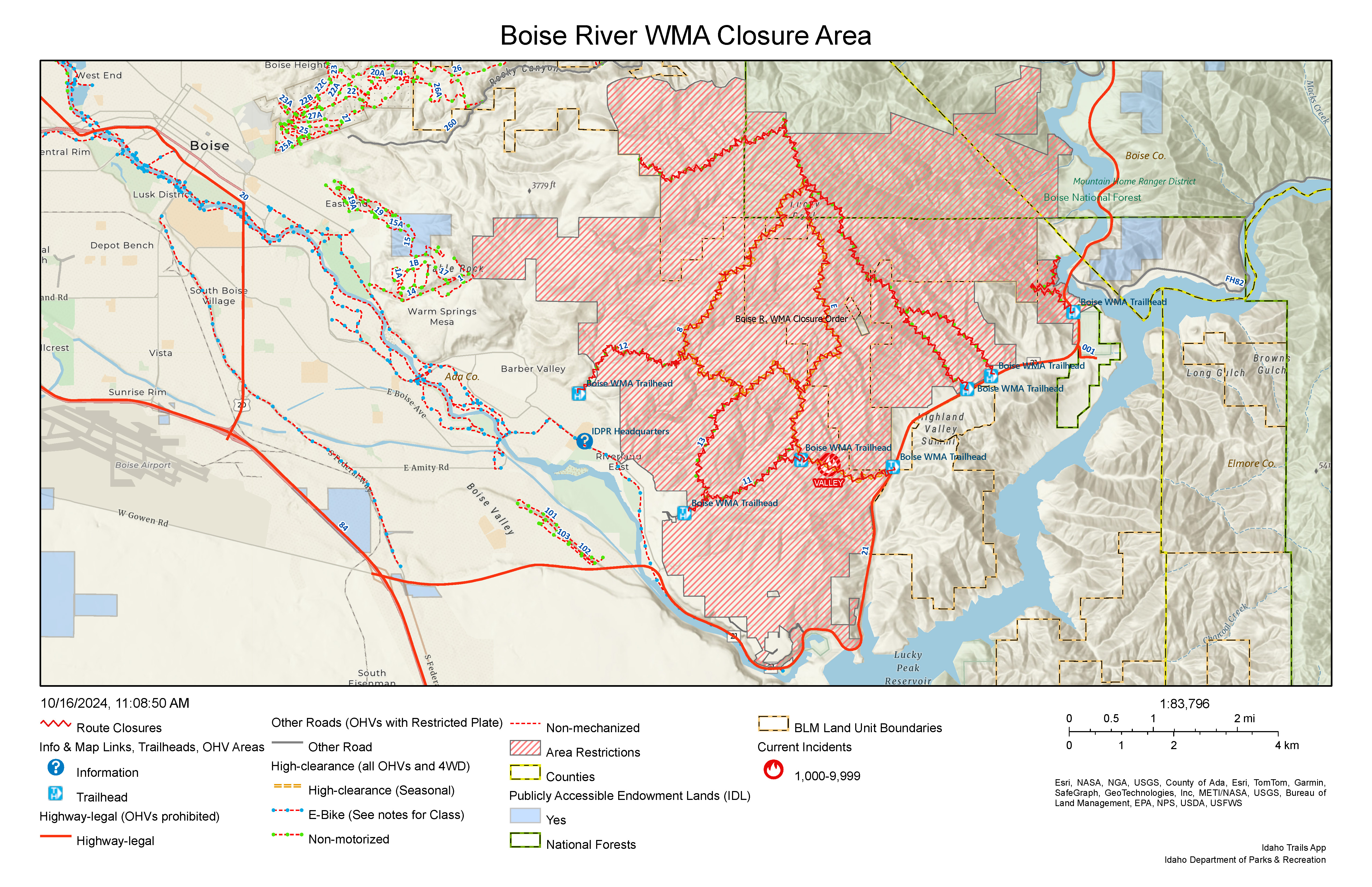
Boise River WMA Closure 10 18 2024
Related Incident: 2024 Valley Fire
Publication Type: Closures
For the safety of the public and the efficiency of firefighting crews, all roads and trails on the Boise Front segment of the Boise River WMA west of Highway 21 and north of Warm Spring Avenue are closed to all entry until further notice. This closure also extends to all travel off roads and trails.
Yellow Lake Fire Daily Update 10 09 2024
Related Incident: Yellow Lake Fire
Publication Type: News
Please see attached file for update.
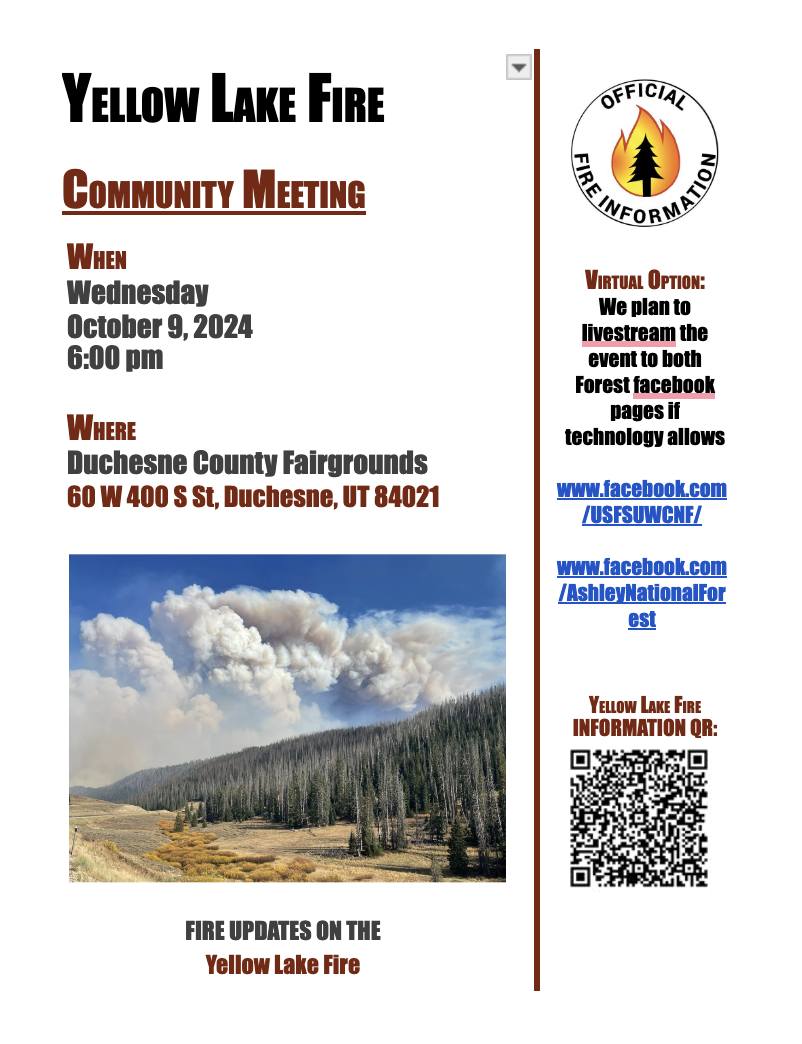
Yellow Lake Fire Community Meeting 10 08 2024
Related Incident: Yellow Lake Fire
Publication Type: Announcement
Yellow Lake Fire Community Meeting
Wednesday, October 9th
6:00 PM
Duchesne County Fairgrounds, 60 W 400 S, Duchesne, UT 84021
This meeting will be streamed, if technology allows, on both the Ashley and Uinta-Wasatch-Cache National Forest's Facebook pages.