
Tiger Creek Fire Daily Update 10 09 2024
Related Incident: Tiger Creek Fire
Publication Type: News
Current Situation: The Tiger Creek Fire is currently 573 acres, and is eleven percent contained with 484 firefighting resources assigned. Crews continue to work toward full suppression of the fire.
A community meeting will be hosted on Wednesday, October 9 at 6:30 p.m. at Walla Walla Fire District 4 Station 5. The fire station is located at, 6531 Mill Creek Road.
Firefighters have been able to contain the fire to the east of Tiger Creek. The Umatilla Veterans Crew and Greyback Crew will be setup in spike camps with full overhead and medical support. Spike camps allow for more time on the ground and cuts travel time to and from their work area. With the dry cold front moving in, crews will monitor for spot fires.
An unmanned aviation system (UAS), otherwise known as a drone, will continue to fly over the area to assist in finding spot fires so they can be quickly addressed. Other aviation resources include three type 1 as well as type 2 and 3 aircraft.
Closures and Restrictions: Access through Forest Service Road (FSR) 65 up through FSR 64 to the junction with Indian Camp is closed. Government Mountain Road/FSR 6511 is closed from North Fork Walla Walla trailhead to the junction with FSR 65 at Tiger Saddle. Government Mountain Rd/FSR 6511 is open from the west to North Fork Walla Walla trailhead. The current fire danger rating is MODERATE and public use restrictions phase A for Umatilla National Forest are in effect. For more information regarding restrictions, please contact Umatilla National Forest Toll-free Information Hotline: 1.877.958.9663.
Weather: A cold front moves in today, which will bring clouds, higher wind speeds, and a rise in humidity. These conditions will limit fire activity and growth. Cloudy today with highs mid 60s to mid 70s with afternoon humidity 45-55%. West-Northwest winds 10-15 mph with gusts around 20-25 mph in the afternoon. Tomorrow will be mostly cloudy with some sun in the afternoon but temperatures around 40-50 degrees.
Smoke: Walla Walla’s air quality for today is good to moderate, some residents along Mill Creek may experience smoke as the fire continues to burn. Check out https://wasmoke.blogspot.com/?m=1 for more information.
Rail Ridge Daily Update 1092024 10 09 2024
Related Incident:
Publication Type: Announcement
Rail Ridge Fire Update
October 9, 2024
Central Oregon Wildfire Information: centraloregonfire.org
Email: 2024.railridge@firenet.gov – Phone: 541-208-7111
Social Media, Evacuation and Closure Information: https://linktr.ee/RailRidgeFire
Acres: 171,087 – Containment: 89% – Detection: 09/02/24 – Cause: Lightning – Personnel: 555
An increase in fire activity was seen yesterday across the entire Pacific Northwest. Poor humidity recovery over night, low daytime relative humidity, high temperatures, and increased winds caused many fires to become more active than days past. Due to fire activity on the northwest side of the Rail Ridge Fire, evacuation levels in Wheeler County were elevated.
Operational Update - Yesterday, the 89% of contained fire edge on the Rail Ridge fire were tested by the weather and held in place. There was an increase in fire activity in the interior portion of the northwest section of the fire in the Black Canyon Wilderness. Multiple spot fires, which occurred from the main fire in Black Canyon, were detected to the northwest of the wilderness, and with the intense fire weather yesterday, there was a spot detected on Cougar Ridge in the afternoon. Firefighters called for assistance from air resources but due to heavy smoke in the area aircraft were unable to drop retardant to stop forward progression on the ridge. On the southern edge of the Black Canyon Wilderness, crews used the winds to their advantage to strengthen the containment line moving to the west.
Today, crews will continue to work on containing the spot fire on Cougar Ridge. Three helicopters are available to support the firefighters on the ground with bucket drops as needed. If deemed necessary and conditions allow, fire retardant will be used to slow the fire growth on Cougar Ridge. Winds are expected to shift today, coming from the west/northwest which will push active fire back towards the interior of the containment lines. Higher humidity and lower temperatures are expected to slow down fire growth and decrease the overall fire activity. Firefighters will evaluate weather conditions to determine if they can continue planned tactical burning operations around Bear Skull.
Weather - Cooler and more moist conditions will finally take hold today. A weak cold front will cross the area, and winds will turn to come from the northwest for this afternoon. Winds may gust as high as 20 mph on ridges and exposed aligned drainages. Relative humidity will moderate today and through the remainder of the week, with minimum relative humidity of 30-35% this afternoon, but strong recovery at over 60% is forecast overnight.
Closures - Forest closures are in place around the Rail Ridge and Crazy Creek Fires. For your safety and the firefighters, please respect closure areas. A map with the ODFW hunting management unit areas overlayed with the closure area and fire footprint can be found at: https://linktr.ee/RailRidgeFire.
For Current Evacuation Levels for all affected counties, please visit: https://linktr.ee/RailRidgeFire.
You can help our firefighters by doing your part, and remember it only takes one spark! The majority of human starts are accidental, know the current fire regulations in your area, be prepared with a fire extinguisher, water and a shovel when out recreating.
Pack Trail Daily Update October 9 2024 10 09 2024
Related Incident:
Publication Type: News
Total Acres: 60,676 (IR Information is delayed – no updated acreage)
Confined: 60% Total Personnel: 571
Community Meeting Thursday October 10, 2024 at 6 P.M. at Museum of Military Vehicles in Dubois
Operations – Yesterday, the Pack Trail Fire pushed southeast into Leeds Creek. Last night, fire crews implemented structure protection in the Cowboy Camp area. Today crews will continue to scout for natural and indirect holding features and build an indirect line along 553 Road. Road crews are beginning work on Union Pass to improve road safety for firefighter vehicles and enhance the fuel break. The west side continues to back down Burnt Ridge. Firefighters will implement structure protection at Elk Track Ranch and Gros Ventre area. Last night, firefighters accomplished a small tactical firing operation to improve control lines and reduce dry, flammable fuels near the 540 Road on the east side. Crews continue to improve indirect holding lines in this area. Sprinklers and structure protection are being implemented in the Long Valley, Teton Youth Camp and Union Pass Subdivision areas. On the north side, there was no new fire activity, but some heat remains in the interior and smoke may be visible. Road crews completed repairs and grading on Flagstaff Road, where crews will continue to patrol.
Safety - Drivers on US-26 may experience periods of smoke today due to high winds. Please use caution while driving, use headlights, and expect to encounter fire vehicles along the road. If planning travel on US-26 across the Continental Divide monitor WY-DOT for possible closures due to fire activity.
Teton Interagency Fire managers are maintaining the Very High Fire Danger Rating for Grand Teton National Park, the Bridger-Teton National Forest, and the National Elk Refuge. Due to excessively dry fuels, any spark can ignite fire which can spread rapidly, becoming a large fire and exhibit extreme fire intensity. Residents and visitors are urged to exercise extreme caution with fire or possible ignition sources. Always build your campfires away from dry grass, leaves, and overhanging branches to reduce the risk of spreading wildfire. Clear at least a 10-foot perimeter around your fire, removing any flammable material, and make sure your fire is dead out and cool to touch before you go to sleep, or leave the area.
Weather – Last night the winds were calm, humidity recovered to 75% and the temperature was between 27-40 degrees. Today will be sunny, temperature in the mid 60s, 10 degrees higher than average, humidity 17-22% and wind speeds from 6-10MPH from the west/southwest with gusts to 24. To learn more about air quality, visit Fire.AirNow.Gov.
Road Closures – Union Pass Road is closed from Union Pass to Buffalo Meadow for firefighter safety.
Evacuations – The Upper Gros Ventre area (Goosewing and Elk Track Ranches) in Teton County have been put into a Level 2 “Set” Evacuation Warning. Evacuations and evacuation alerts for several subdivisions and ranches in Fremont County, WY remain in place. See the Fremont County Emergency Management Facebook Page for alerts and updates. See the Teton County Emergency Management website updates and to sign up for emergency alerts through Everbridge.
Forest Closures - Closure Order #04-03-24-315 is in effect from October 7 at 12:00 p.m. through November 1, 2024 at 6:00 a.m. unless rescinded. This order supersedes previous orders, including #04-03-24-314, prohibiting the same or similar acts in the same described area.
For more information, visit: Facebook: USDA Forest Service - Bridger-Teton National Forest, USDA Forest Service - Shoshone National Forest Pack Trail Inciweb: https://inciweb.wildfire.gov/incident-information/wybtf-pack-trail-fire
GARDEN FIRE UPDATE OCTOBER 9 2024 10 09 2024
Related Incident:
Publication Type: News
GARDEN FIRE UPDATE OCTOBER 9, 2024
https://inciweb.wildfire.gov/incident-information/idscf-garden-fire
...RED FLAG WARNING IN EFFECT FROM NOON TO 9 PM MDT TODAY FOR GUSTY WINDS AND LOW RELATIVE HUMIDITY…
Fire Size: 8,379 acres
Cause: lightning
Location: approximately two (2) miles southwest of the confluence of Panther Creek and the Main Salmon River on the North Fork Ranger District in the Frank Church River of No Return Wilderness.
Fuels: grass, brush, dead and down fuels, and timber
Resources: 173 people with additional resources arriving today.
Fire situation: Firefighter and public safety is the number one priority for the Garden Fire. Fire managers are using a combination of full suppression and a point protection strategy (a wildfire response strategy, which protects specific assets or highly valued resources from the wildfire without directly halting the continued spread of the wildfire) to minimize exposure to fire personnel while protecting identified values, including private property and Forest Service infrastructure.
The fire continues to grow in the Garden Creek drainage and to the ridge to the north, towards the Salmon River. Fire is currently holding in the upper reaches of Clear Creek, however between lower Clear Creek and Dry to Bear Gulch, the fire is backing down towards Panther Creek. Fire managers were able to use an Unmanned Aircraft System (UAS) for small scale fire operations yesterday to help secure the fire’s edges. While visibility is improving, use of the UAS continues for infrared flights so fire managers can continue to monitor fire movement.
Presence of firefighters, primarily in the Panther Creek and Salmon River areas on both a day and night shift, will continue today. Crews are preparing for the anticipated winds and are strategically placed to respond in case the fire spots over the Salmon River. Aircraft, both fixed wing and helicopters, will be used if weather and smoke conditions allow. Fire managers are continuing to look for opportunities to engage the fire direct as fuels and weather conditions change and it is safe to do so.
Evacuations: Lemhi County Law Enforcement, Emergency Management, and the Salmon-Challis National Forest have established three (3) evacuation zones for the Garden Fire.
Zone 1: From Cove Creek to Ebeneezer Bar, downriver along the Salmon River Road #030.
Zone 2: On Panther Creek Rd #055, a half mile south of Beaver Creek Rd #057 to the Salmon River Rd #030 confluence.
Zone 3: Panther Creek to Spring Creek to include private land up Spring Creek
ZONE 1 is in “GO” status
ZONE 2 is in “GO” status
ZONE 3 IS IN "READY" STATUS
Information on evacuation status can be found on Lemhi County’s website, https://www.lemhicountyidaho.org/, under ‘News and Notices.’
Weather: ...RED FLAG WARNING IN EFFECT FROM NOON TODAY TO 9 PM MDT THIS EVENING FOR GUSTY WINDS AND LOW RELATIVE HUMIDITY...As a dry cold front passes overhead today, look for an increase in winds and cloud cover with gusts peaking around 25-35 mph and RH in the teens. Under the continued influence of a broad region of a high pressure overhead, look for seasonably warm and dry conditions to continue into early next week.
Closures: There are two closures associated with the Garden Fire. The Red Rock/Black Eagle and Garden Fire Closure #004-13-24-024 and the Garden Fire Closure #04-13-24-025 can be found at on the Salmon-Challis National Forest Website at https://www.fs.usda.gov/alerts/scnf/alerts-notices. Closure #04-13-24-025 was put in place due to current fire behavior and predicted winds of 18-23 mph with gusts to 30-35 mph, with a 0% chance of wetting rain in the next seven (7) days. With these conditions, the Garden Fire has the potential to spot across the Salmon River to the north. If the fire spots across the river, with current fuel conditions and predicted winds, the fire has a potential to make a large run.
Visit our website at: www.fs.usda.gov/scnf/, ‘Like Us’ on Facebook @salmonchallisnf, and ‘Follow Us’ on X @salmonchallisnf.
####
HomesteadDiamond Complexes Daily Fire Update 10 09 2024
Related Incident: Lane 1 Fire
Publication Type: News
Homestead/Diamond Complexes Fire Update
Oct. 9, 2024
Fire Information: 541-208-7100, 8 AM - 5 PM
InciWeb-Homestead: https://t.ly/syeHa and InciWeb-Diamond: https://bit.ly/4gCfLsp
Northwest Team 12 will be transitioning command of the fires today to a local Umpqua National Forest Type 3 team at 6 PM. This will be the final daily fire update for the Homestead and Diamond Complex Fires. For further fire and closure updates, please contact the Umpqua National Forest at 541-440-4930. Northwest Team 12 would like to thank the community of Glide for hosting the fire team for the duration of the fires.
The Oregon Department of Transportation is resuming normal speed limits on Hwy 138 in front of the fire Incident Command Post tomorrow. Public safety closures will remain in effect due to heavy equipment working on roads and active fire behavior.
Homestead Complex: 11,297 acres, 35% contained │ Diamond Complex: 11,141 acres, 90% contained │ Total personnel: 276
Cooler temperatures and higher humidity moderated fire behavior yesterday, however due to lack of precipitation over the past few weeks, fuels remain dry and continue to consume.
The Horse Heaven Fire saw minor growth over the past 24 hours, with spot fires establishing to the north of the main fire perimeter. Two heavy helicopters dropped a total of approximately 32,000 gallons of water to slow fire activity. Firefighters continue to patrol and monitor fire activity to determine the need for helicopter water drops today. Engine crews continue seeding and spreading straw over dozer lines as part of fire suppression repair to prevent erosion. Grading will resume along Forest Service Road (FSR) 2212.
Numerous spot fires north of FSR 3810 on the Fuller Lake Fire challenged firefighters yesterday. Crews will continue to monitor spot fire growth and will utilize aerial water drops if necessary to keep the fires in check. On the Bullpup Fire, crews will be cutting stumps lower to the ground and an excavator will continue working FSR 380.
Smoldering continues to pose no threat on the No Man Fire, but firefighters will continue to patrol for flare ups as underground smoldering in deep duff layers can go undetected.
Road work continues on the Diamond Complex. Graders are being moved around to assist with suppression repair on roads within the complex, including those adjacent to the Brodie and Lemolo Fires.
Closures: The Umpqua National Forest revised the fire closure area on Friday. Please respect area closure orders for your safety as well as the safety of our firefighters. The updated Umpqua National Forest closure and map can be found at https://tinyurl.com/bmtfvvz6. The BLM Roseburg District closure order also remains in place https://t.ly/uWX6l. A Temporary Flight Restriction remains in effect https://bit.ly/3XJL0cD.
Weather: Temperatures today will be 60-70 degrees in the valleys today. There is a slight chance of showers this morning.
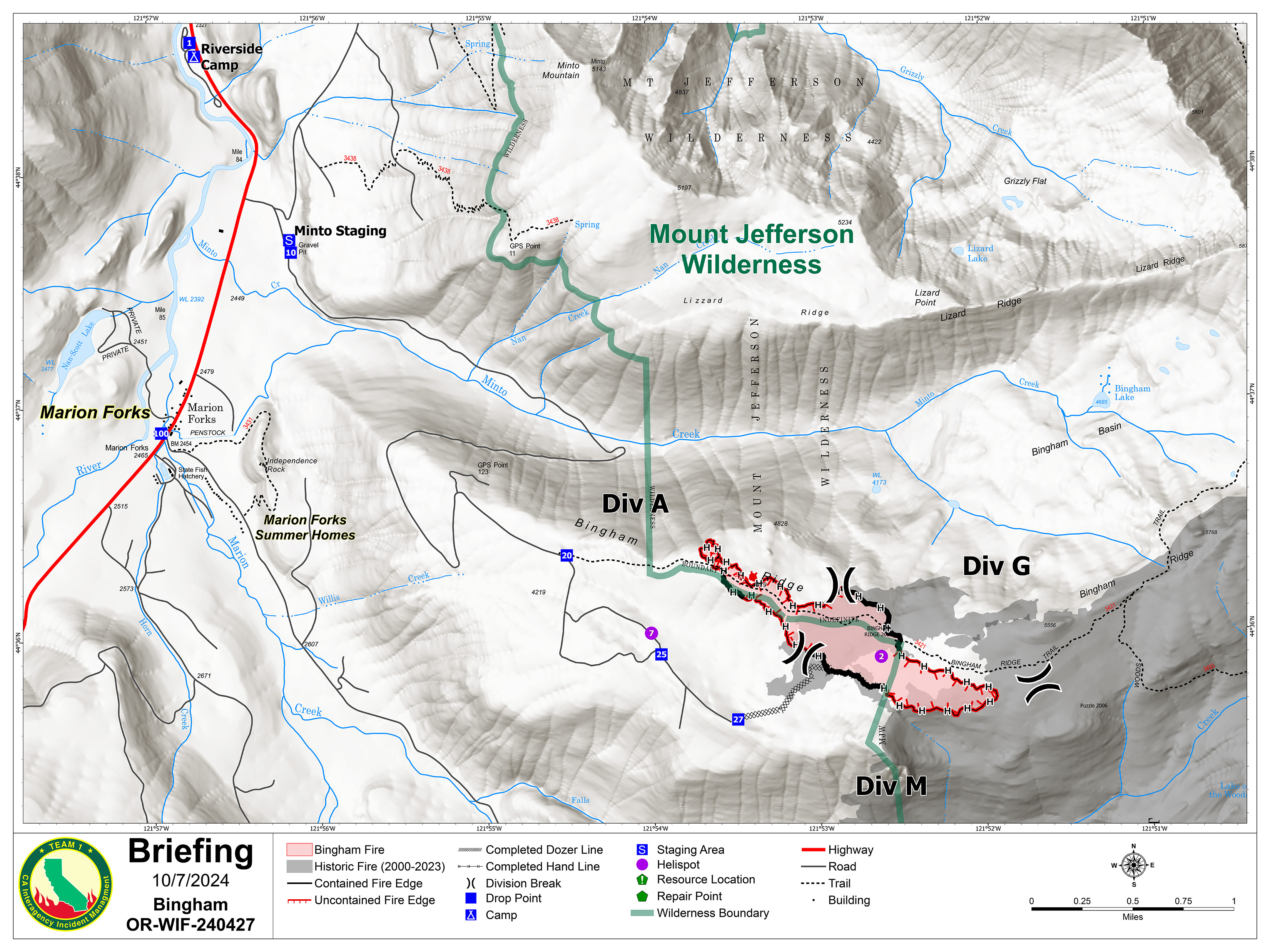
Bingham Fire Daily Update Wednesday October 9 2024 10924 1092024 10 09 2024
Related Incident: Bingham Fire
Publication Type: News
2,400 pounds of water-handling equipment air lifted to firefighters
Daily Update: October 9, 2024
Fire Information Phone: 503-854-3366 (8 a.m.-8 p.m.)
Email: 2024.Bingham@firenet.gov
Acres: 199 Containment: 53%
Location: Areas of the Mount Jefferson Wilderness, east of Marion Forks.
Start Date: September 30,2024 Personnel: 384
Resources: 14 crews | 5 engines | 1 bulldozer | 3 water tenders | 1 masticator
Highlights: Helicopters made multiple deliveries of water-handling equipment Tuesday, Oct. 8, to firefighters as they kept the Bingham Fire to 199 acres and increased containment to 53 percent.
Crews were aided by the delivery of 2,400 pounds of equipment used to store and dispense water, such as bladder bags (backpack water pumps) and blivets (containers holding 55 to 72 gallons of water used to refill bladder bags). The equipment allowed firefighters to douse heat sources along the fire’s perimeter and deeper into its interior, widening containment lines up to 50 feet in a number of areas.
Crews will continue patrolling containment lines and extinguishing hot spots. Increased air traffic might be observed over the fire as helicopters deliver and retrieve additional equipment during the next few days.
Evacuations: LEVEL 3: GO NOW! Evacuation alerts have been issued by the Linn County Sheriff’s Office for a large area of the Mount Jefferson Wilderness. Additionally, LEVEL 2: GET SET evacuation alerts have been issued for the area around Marion Forks Campground and Marion Forks Fish Hatchery. The Level 2 evacuation area also extends along Highway 22, to a ½-mile west of Highway 22, from Pamelia Road (NFS Road 2246) south to Parrish Lake Road (NFS Road 2266). Please refer to the Linn County Wildfire Map for more information: https://tinyurl.com/LinnCoFireMap. Highway 22 remains open.
The Willamette National Forest issued a closure order Oct. 4 within the same footprint as the Level 3 evacuation zone. Details of the closure order can be found here: https://tinyurl.com/26jpr9a6. The Pacific Crest Trail through the Mount Jefferson Wilderness is expected to remain open. Trails and roads west of the highway are closed from Pamelia to the Big Meadows Loop/Turpentine Loop area. With hunting season started, Forest Service staff will work with the Linn County Sheriff’s Office to reduce closure areas as soon as it is safe to do so.
Weather: Temperatures have cooled today to the mid-50s and lower 60s with possible wind gusts up to 18 miles an hour. Relative humidities have increased to between 65 to 70 percent along with a 20 percent chance of rain.
Settings - change map background and toggle additional layers
Filter - control incident types displayed on map.
Zoom to your location
Reset map zoom and position
Could not determine your location.
Show Legend
 Wildfire
 Prescribed Fire
 Burned Area
Response
Burned Area
Response Other
Other
Bogus Lake Fire
Unit Information
Incident Contacts
Wapiti Fire BAER Summary Report Available 10 09 2024
Related Incident:
Publication Type: News
The Forest Service Burned Area Emergency Response (BAER) team assigned to the Wapiti Fire has completed its emergency assessment of the fires. One of the main objectives of their assessment is to identify critical values at risk of additional damage due to recent wildfires. Once they identify those values, they outline the risks and suggest mitigation actions (treatments) to minimize future risk.
BAER teams created an executive summary that provides a glimpse into the scientific analysis and results of their assessment. The linked summary (below) contains a simplified summarization of the work performed by the BAER team. Please note that treatments identified in these summary documents reflect proposed, but not yet authorized, activities.
Forest Service officials are working closely with local and state agencies on immediate and longer-term recovery needs. Suppression repair and other mitigation work has been occurring in many areas and BAER recommended actions will begin as soon as practical.
The linked report below is an executive summary of the team's findings. For additional information, please reach out to the BAER coordinators for the Sawtooth and Boise National Forests.
Sawtooth: Tom Stewart, thomas.stewart@usda.gov
Boise: Matt Robinson, matthew.robinson@usda.gov
Frog Fire Daily Update 10 09 2024
Related Incident: Frog
Publication Type: News
Frog Fire Quick Facts
Fire Size: 3,020 Acres
Containment: 100%
Total Personnel: 28 (firefighting resources will be removed this evening and the incident will be placed into monitor status)
Great Basin IMT 3 will be transitioning the incident back to the local unit for management this evening at 6 P.M.
Elk Fire Update Wednesday October 9 2024 10 09 2024
Related Incident: Elk Fire 2024
Publication Type: News
Elk Fire Update – October 9, 2024
Rocky Mountain Area Complex Incident Management Team 3
Casey Cheesbrough, Incident Commander
Date Reported: Friday, September 27, 2024
Cause: Lighting
Size: 75,969
Containment: 16%
Total Personnel: 889
Location: Approximately 6 miles northwest of Dayton extending 6 miles southeast of Dayton, Wyoming
Key Messages: There will be a community meeting—particularly for residents of Story and Big Horn— Wednesday, October 9, at 7:00 pm at Big Horn High School, 333 WY-335. Attendees will get an update on the fire and evacuations. They will also have an opportunity to ask questions and have one-on-one conversations with agency representatives and fire managers. The meeting will be recorded and posted to the incident’s YouTube channel (www.youtube.com/@2024ElkFire) and the Bighorn National Forest’s Facebook Page (Facebook.com/bighornnf).
At 3:00 a.m., due to high, gusty winds and low humidity, fire behavior increased significantly northwest of the Big Goose Water Treatment Plant. Nearby resources working the night shift—one dozer, one hotshot crew, and eight engines—responded to the area. The weather today will be warmer, drier, and the fire will likely be more active. Numerous aircraft are assigned to the incident and will be conducting water and retardant drops.
Current Situation: On the fire’s northern side, a hotshot crew conducted additional firing operations and air operations dropped fire retardant yesterday off the 144 Road. Today, the crews will continue to prepare the 144 Road and conduct more firing operations to protect the Little Bighorn Canyon. That area of the fire is active and in steep drainages that are producing smoke.
Containment on the northeastern side of the fire increased from 10 percent to 16 percent yesterday. A containment line in a wildland fire is a barrier that prevents the fire from spreading. It can be a natural barrier, like a river or road, or a constructed barrier, like a trench dug by firefighters.
On the southeastern and southern parts of the fire, mop up and patrolling continues in the Crystal Springs area. Firefighting crews will continue to build additional control lines and prepare areas for potential low-intensity, strategic firing operations that would protect the watershed and associated water-treatment plant structures. In the southern portion of the fire, road graders are working alongside firefighting resources on Red Grade Road, and structure protection in the Poverty Flats area will continue today.
On the western side of the fire in the Burgess Junction area, structure protection is in place. Firefighters remain in place to protect structures and engage the fire if necessary. There will be heavy equipment in the area today prepping the 15 Road. Strategic firing operations may be conducted today if weather conditions are favorable.
Weather & Fire Behavior: Unseasonably hot, dry conditions will peak on Wednesday. Winds will be from the southwest with gusts up to 20 mph expected. Vegetation is extremely dry and receptive to burning. Fire activity and smoke production are likely to increase on the fire’s western and southern sides. For air-quality and smoke information, refer to the AirNow website: airnow.gov.
Evacuations and Closures:
The Sheridan County Sheriff's Office downgraded the following zone from Go to Set evacuation status level on Tuesday: Slack Road at the Montana border and then in a southwesterly direction to the northeast corner of the Kerns Elk Refuge then in a southern direction to the Forest Service boundary. Refer to the evacuation-status map and news release on the Sheridan County Emergency Management website: tinyurl.com/2s38bcc5. You can also call either the Sheridan County Sheriff’s Office (307-672-3455) or Sheridan County Emergency Management (307-752-2174).
On Tuesday, the Wyoming Department of Transportation (WYDOT) reduced the road closure on US Highway 14 north of the Antelope Butte Ski Area and US 14A east of Lovell. To accommodate access to Hunt Area 40 outside of the Elk Fire closure areas west of Burgess Junction, the Wyoming Highway Patrol moved two staffed closures to milepost 85.6 (Hunt Mountain Road/FS10 on US 14A) and milepost 38.3 (Granite Pass/Hunt Mountain Road/FS 10 on US 14). View the map here: wyoroad.info. Motorists will encounter barricades with no access on US 14A at Forest Service Road 14 (Sheep Mountain/Devils Canyon) and FS 15 (Dayton Gulch) located within the Forest Service Elk Fire closure. The Bighorn National Forest, WYDOT, and the Wyoming Game and Fish Department ask motorists and hunters to be mindful of firefighting equipment in the area and familiar with the boundaries of the Elk Fire.
Bighorn National Forest lands around the Elk Fire are closed under Order 02-02-06-24-08. The order and map can be viewed on the forest’s alerts web page: fs.usda.gov/alerts/bighorn/alerts-notices.
Evacuation Shelter: An emergency shelter has been established at the fairgrounds in Sheridan and can accommodate numerous people, campers, and animals. To make arrangements for people or animals, call 307-752-2174 or 307-683-6965.
Elk Fire Information:
Phone: 307-303-7642 (8 am to 8 pm)
Email: 2024.Elk@firenet.gov
Linktree: linktr.ee/2024ElkFire