
Pack Trail Fire Daily Update October 8 2024 10 08 2024
Related Incident:
Publication Type: News
Pack Trail Fire Phone: 307-395-2351 Email: 2024.Packtrail@firenet.gov
Total Acres: 60,676
Total Personnel: 563
Confined: 60%
Operations – Yesterday, on the west side of the fire, parallel to the Purdy Fire footprint, the fire continued to move south into Leeds Creek, but remained east of Burnt Ridge. Fire crews are implementing structure protection in the Gros Ventre area and continuing to scout for natural and indirect holding features. On the north side, there was minimal fire activity. Road crews are continuing repairs and grading on Flagstaff Road. On the east, if weather permits, fire crews will conduct a strategic firing operation to improve control lines and reduce dry and flammable fuels. Firefighters continue to strengthen indirect holding lines near the 540 Road. East of Highway 26, in the Pinnacles and Brooks Lake areas, crews will continue to set up sprinklers and place structure protection as needed. On the south, fire crews will continue to build an indirect line along the 553 Road.
Safety - Drivers on US-26 may experience periods of smoke today due to high winds. Please use caution while driving, use headlights, and expect to encounter fire vehicles along the road. If planning travel on US-26 across the Continental Divide monitor WY-DOT for possible closures due to fire activity.
Teton Interagency Fire managers are maintaining the Very High Fire Danger Rating for Grand Teton National Park, the Bridger-Teton National Forest, and the National Elk Refuge. Due to excessively dry fuels, any spark can ignite fire which can spread rapidly, becoming a large fire and exhibit extreme fire intensity. Residents and visitors are urged to exercise extreme caution with fire or possible ignition sources. Always build your campfires away from dry grass, leaves, and overhanging branches to reduce the risk of spreading wildfire. Clear at least a 10-foot perimeter around your fire, removing any flammable material, and make sure your fire is dead out and cool to touch before you go to sleep, or leave the area.
Weather – Last night the winds were calm, humidity recovered to 60% and the temperature was between 22-40 degrees. Due to the overnight inversion that allowed smoke to collect in the valleys, today will be smoky again. Today will be partly cloudy, temperature in the mid 60s, and wind from the west/northwest will increase to 10 MPH once the inversion lifts with gusts to 28 near the ridgetops. To learn more about air quality, visit Fire.AirNow.Gov.
Forest Closures - Closure Order #04-03-24-315 is in effect from October 7 at 12:00 p.m. through November 1, 2024 at 6:00 a.m. unless rescinded. This order supersedes previous orders, including #04-03-24-314, prohibiting the same or similar acts in the same described area. Click here to access the closure order and map on InciWeb.
Evacuations – The Upper Gros Ventre area (Goosewing and Elk Track Ranches) in Teton County have been put into a Level 2 “Set” Evacuation Warning. Evacuations and evacuation alerts for several subdivisions and ranches in Fremont County, WY remain in place. See the Fremont County Emergency Management Facebook Page for alerts and updates. See the Teton County Emergency Management website updates and to sign up for emergency alerts through Everbridge.
Facebook: USDA Forest Service - Bridger-Teton National Forest, USDA Forest Service - Shoshone National Forest
Pack Trail Inciweb: https://inciweb.wildfire.gov/incident-information/wybtf-pack-trail-fire
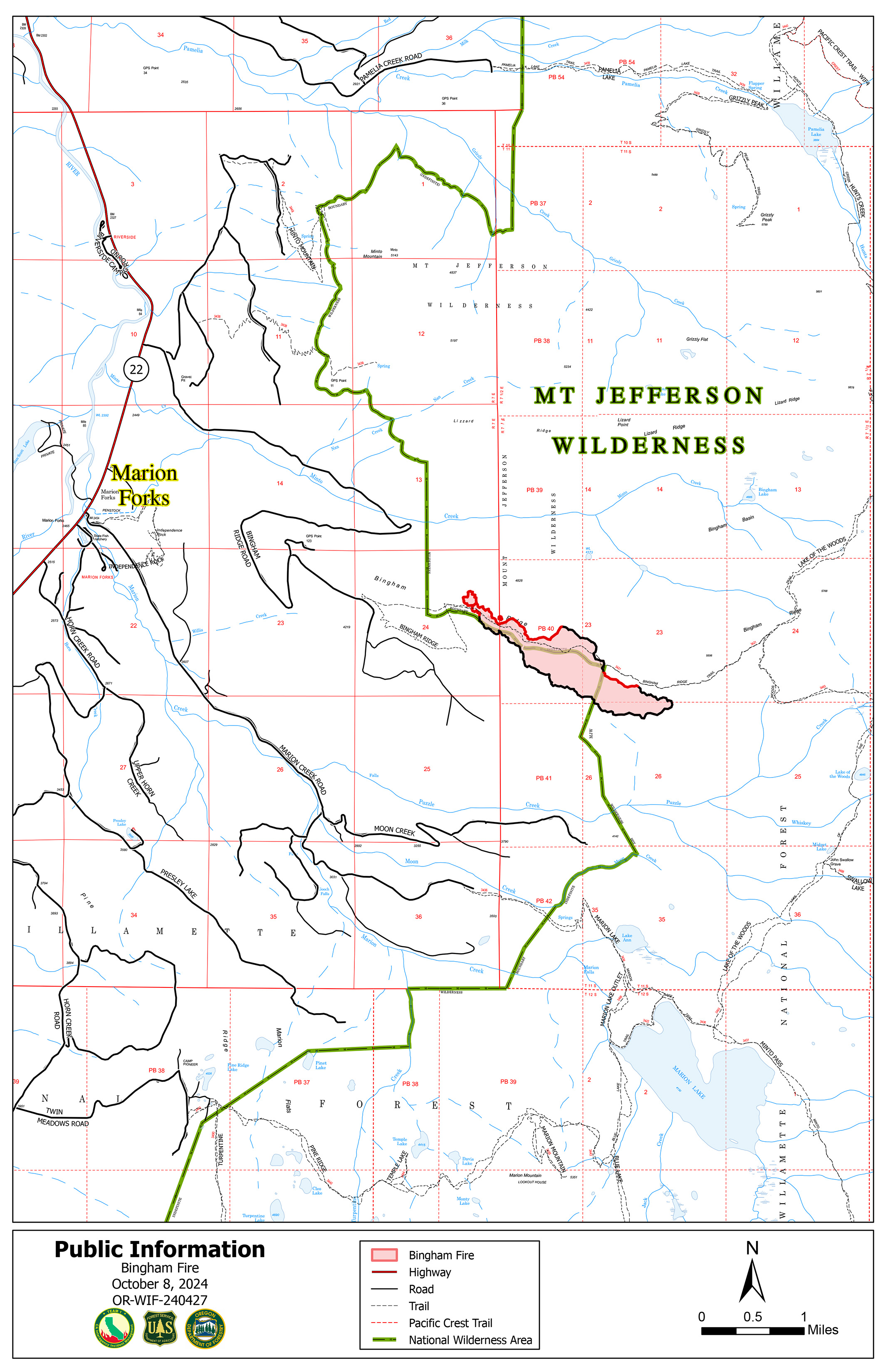
Bingham Fire Daily Update for Tuesday October 8 2024 100824 10 08 2024
Related Incident: Bingham Fire
Publication Type: News
Containment climbs to 43% in Bingham Fire
Daily Update: October 8, 2024
Fire Information Phone: 503-854-3366 (8 a.m.-8 p.m.)
Email: 2024.Bingham@firenet.gov
Acres: 199 Containment: 43%
Location: Areas of the Mount Jefferson Wilderness, east of Marion Forks.
Start Date: September 30,2024
Personnel: 334
Resources: 9 crews | 12 engines | 1 bulldozer | 2 water tenders | 2 excavators Highlights:
Containment of the Bingham Fire continued to grow, reaching 43 percent today. The fire also grew slightly to 199 acres from 183 acres previously. The increased containment was achieved along more segments of the northern and southern perimeters of the fire, as well new containment around its eastern end.
Firefighters will focus efforts today widening containment lines and extinguishing sources of heat farther into fire’s interior. Crews also will continue building contingency containment lines near and around the community of Marion Forks, which is situated about 2 miles northwest of the fire’s western boundary.
Work will include removing dead or hazardous trees along forest roads that could block access or escape or even cause injury to homeowners or other motorists visiting the area.
Evacuations: LEVEL 3: GO NOW! evacuation alerts have been issued by the Linn County Sheriff’s Office for a large area of the Mount Jefferson Wilderness. Additionally, LEVEL 2: GET SET evacuation alerts have been issued for the area around Marion Forks Campground and Marion Forks Fish Hatchery. The Level 2 evacuation area also extends along Highway 22, to a ½-mile west of Highway 22, from Pamelia Road (NFS Road 2246) south to Parrish Lake Road (NFS Road 2266). Please refer to the Linn County Wildfire Map for more information: https://tinyurl.com/LinnCoFireMap. Highway 22 remains open at this time.
The Willamette National Forest issued a closure order Oct. 4 within the same footprint as the Level 3 evacuation zone. Details of the closure order can be found here: https://tinyurl.com/26jpr9a6. The Pacific Crest Trail through the Mount Jefferson Wilderness is expected to remain open. Trails and roads west of the highway are closed from Pamelia to the Big Meadows Loop/Turpentine Loop area. With hunting season started, Forest Service staff will work with the Linn County Sheriff’s Office to reduce closure areas as soon as it is safe to do so.
Weather: Temperatures have cooled to the mid-60s and are accompanied by higher humidity. A chance of rain is forecast for Wednesday
Line Fire Daily Update 10082024 10 08 2024
Related Incident: Line Fire
Publication Type: News
Current Situation:
Along Siberian Creek, crews successfully controlled hotspots with the help of aerial resources. Aircraft were used to extinguish hotspots in the Miles Creek area at the northern Santa Ana River drainage. Fireline is continuing to hold in this area. Firefighters continue constructing dozer lines and conducting backhaul operations. In Angelus Oaks, a green island continues to burn safely, with crews continuing clean-up and suppression repair. Demobilization of some crews and resources will be happening over the next few days. Crews that remain will be focused on suppression repair, as well as direct and indirect line construction. The North and South repair groups are focused on road grading and clearing operations.
Winds have become more active, with gusts reaching up to 25 mph. Wind patterns will remain variable throughout the day, with particular gust potential near the Big Bear Airport. The forecast indicates temperatures will drop by 5 degrees in the coming days, but the wind remains the primary concern for fire activity. Inaccessible areas at the confluence of Bear and Siberia Creeks are susceptible to slope reversals due to the continuing dry, hot weather patterns. Fire conditions remain challenging as the Energy Release Component (ERC) has reached the 95th percentile, indicating that the fire is primed for heightened activity.
Highway 38 is reopening to the public today. Angelus Oaks has moved to open status, and the Seven Oaks, Barton Flats and Pinezanita communities have transitioned to an evacuation warning.
Highway 330 remains closed from Highland Avenue to Highway 18 as CalTrans performs repairs to the road and guardrails.
The closure orders for the San Bernardino National Forest remain in place.
Public information line: 909.220.4292
Media Line: 925.542.9164
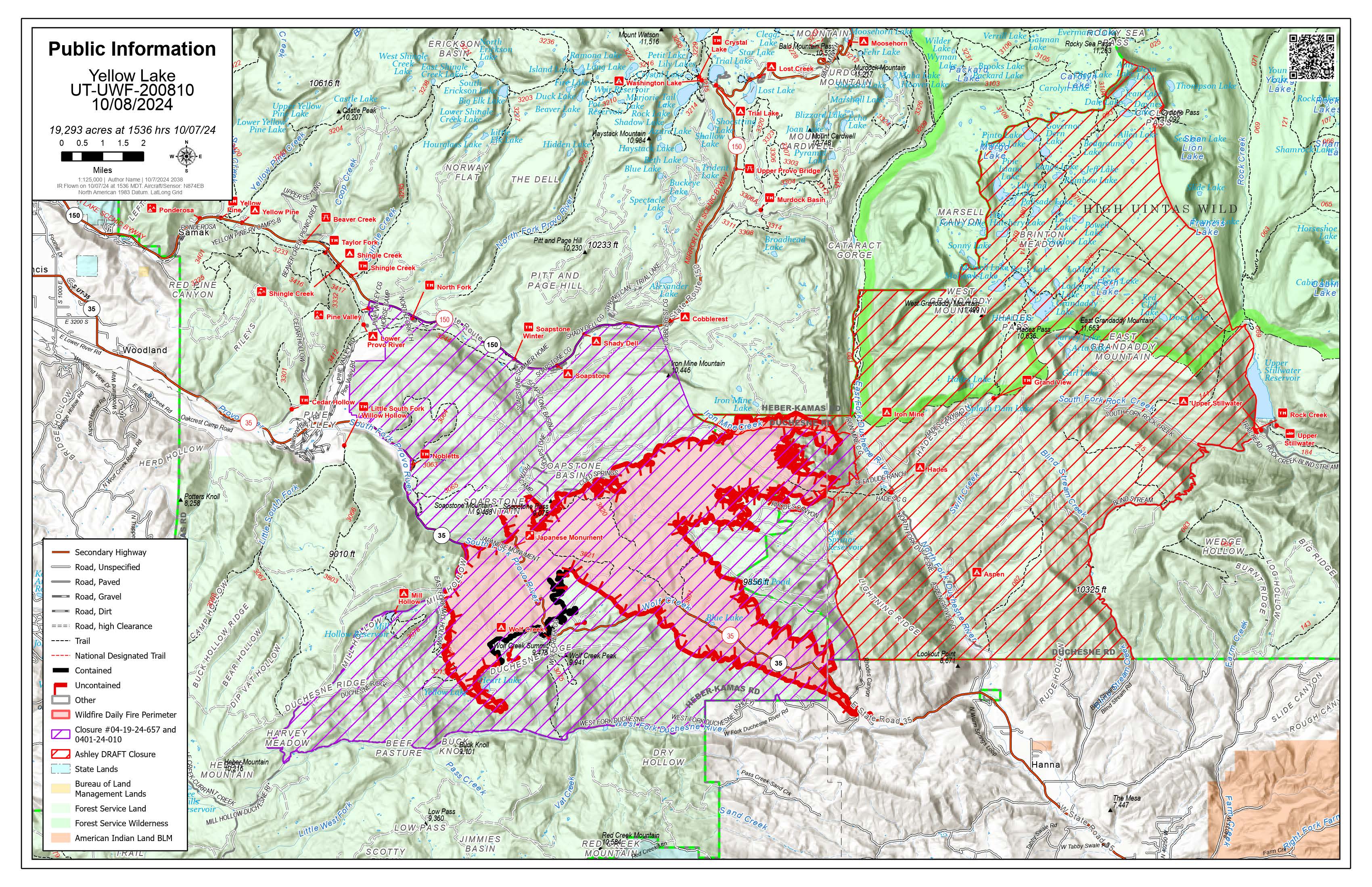
Yellow Lake Update 10 08 2024
Related Incident: Yellow Lake Fire
Publication Type: News
10-8-24— Overnight infrared mapped the Yellow Lake Fire 19,903 acres and 10% containment. As a small storm system moves into the area, the smoke inversion settled into the surrounding valleys, along with ash in some areas. This was predicted, and the increase in smoke does not mean an increase in fire activity or an increased threat.
Winds have been variable, changing directions throughout the day. This requires firefighters to pay especially close attention, as wind direction and fire behavior can be erratic. The fire was active in the Iron Mine drainage yesterday and throughout the night. With topography alignment and fire behavior, this threatened the structures south along the North Fork of the Duchesne Ridge. The firefighters were able to defend the road and all structures, thanks to the structure protection that had been completed.
Firing operations are finished along the Mill Hollow Road, and crews are beginning to mop up and secure this edge. Fire managers expect to gain containment on this side of the fire in the next few shifts, if it continues to hold and reduce heat. The work in Soapstone is promising, as crews keep the fire mostly south of Soapstone Road. Crews have seen minimal growth along this perimeter in the last few shifts and are beginning to mop up and secure this area.
The southwest corner continues to be difficult for crews in the Heart Lake area, working buckets of water most of the day but still seeing a great deal of heat. Another reminder that while air attack supports ground crews, it does not suppress highly active fires.
The southeast side utilized a retardant line to strengthen a fuel break, and secure Highway 35. Firefighters may continue to do firing operations throughout the day to reduce the available fuels along the road, as conditions allow. The southern perimeter continues to produce a significant amount of smoke as the fire burns in patches of dead timber.
Evacuation orders remain the same: The North and West Forks of the Duchesne River are under a mandatory GO evacuation. All residents, hunters and recreationists must evacuate and stay out of the area. The Granddaddy Lakes area on the Ashley National Forest and Hanna was issued a READY order, which prompts residents to have bags packed and be ready to leave if an evacuation order is given.
HomesteadDiamond Complexes Daily Fire Update 10 08 2024
Related Incident: Lane 1 Fire
Publication Type: News
Homestead/Diamond Complexes Fire Update
Oct. 8, 2024
Fire Information: 541-208-7100, 8 AM - 8 PM
InciWeb-Homestead: https://t.ly/syeHa and InciWeb-Diamond: https://bit.ly/4gCfLsp
Six fires within the Homestead and Diamond Complexes remain under active management by Northwest Team 12. Firefighting resources from the Homestead/Diamond Complexes remain available for initial attack response to new fire starts in the area as needed. Public safety closures will remain in effect due to heavy equipment working on roads and active fire behavior.
The Oregon Department of Transportation temporarily lowered the speed limit on Hwy 138 in front of the Fire Incident Command Post just east of Glide to 45 MPH for the safety of firefighters and community residents.
Homestead Complex: 11,073 acres, 35% contained │ Diamond Complex: 11,141 acres, 90% contained │ Total personnel: 288
Fuels continued to dry out and become more available to burn as the fire areas saw the highest temperatures of the recent warming and drying trend yesterday, with a corresponding increase in fire behavior. Today conditions begin to cool, and humidity will increase as more fall-like weather moves into the area helping to subdue fire behavior.
Fire activity on the Horse Heaven Fire picked up in the afternoon, establishing across hand line on the northwest flank and moving toward Calapooya Divide. Fire managers called in a heavy helicopter to drop approximately 23,000 gallons of water to slow fire spread. Today crews will continue seeding and spreading straw over dozer lines as part of fire suppression repair to prevent erosion. Grading on Forest Service Road (FSR) 010 is complete and an excavator is constructing rolling dips on FSR 050 to improve drainage.
The Fuller Lake Fire was very active yesterday in the Bradley Lake Area and within the Boulder Creek Wilderness. An infrared flight from overnight helped fire managers assess the fire spread and identify the growth perimeter. With milder conditions today, fire activity is expected to moderate, allowing firefighters to reinforce control features. Patrols will continue to be watchful and secure flare ups or spot fires. Along a secured portion of the Bullpup Fire firefighters will begin dismantling and backhauling several miles of hose line.
On the No Man Fire, firefighters will continue to patrol for flare ups as underground smoldering in deep duff layers can go undetected.
Road work continues on the Diamond Complex. Graders are being moved around to assist with suppression repair on roads within the complex, including those adjacent to the Brodie and Lemolo Fires.
Closures: The Umpqua National Forest revised the fire closure area on Friday. Please respect area closure orders for your safety as well as the safety of our firefighters. The updated Umpqua National Forest closure and map can be found at https://tinyurl.com/bmtfvvz6. The BLM Roseburg District closure order also remains in place https://t.ly/uWX6l. A Temporary Flight Restriction remains in effect https://bit.ly/3XJL0cD.
Weather: Cooler weather with increased relative humidity is forecasted for today and tomorrow, with valley temperatures expected to be 68-74 degrees today.
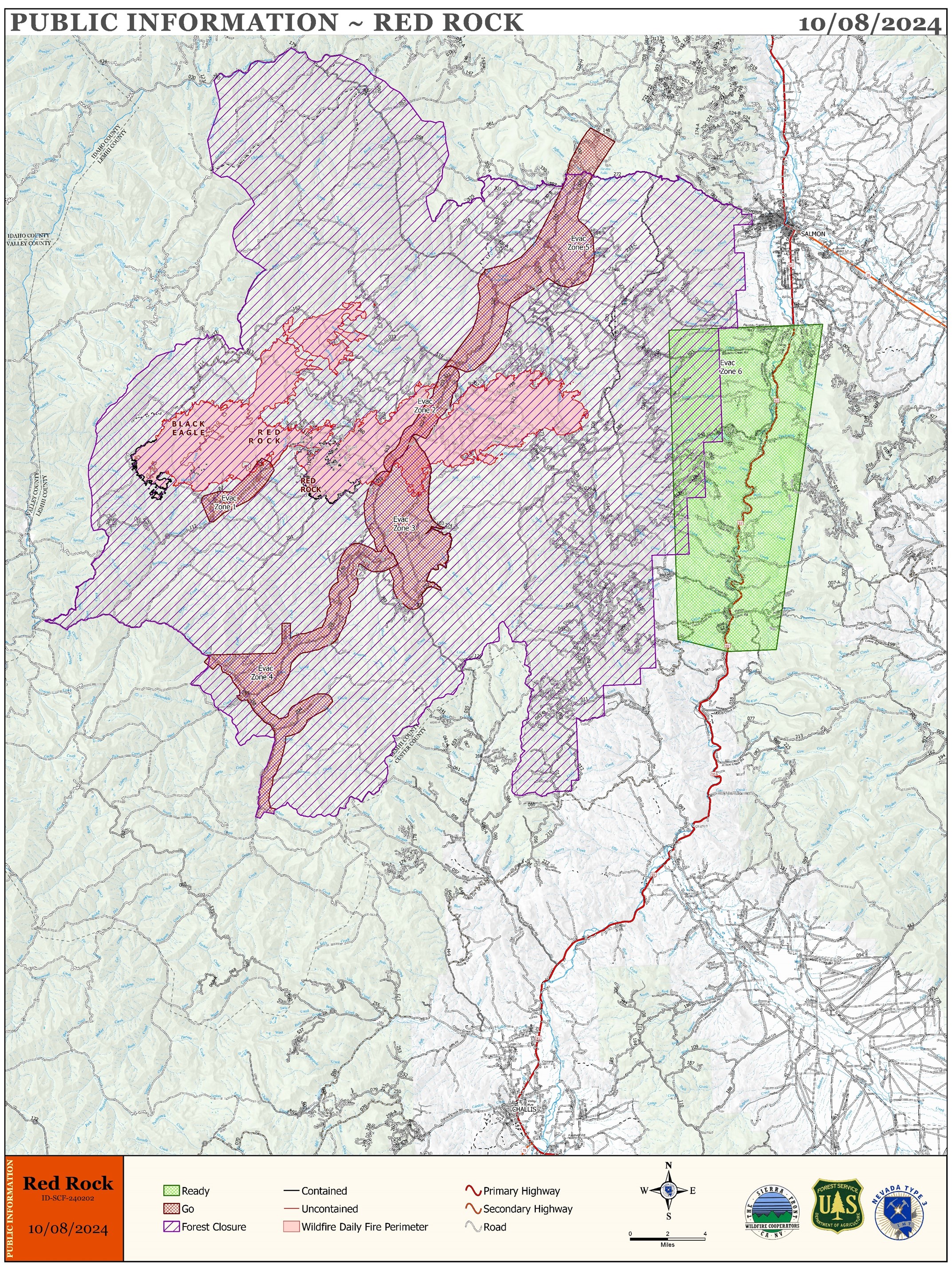
Red Rock Fire Daily Update 10 08 2024
Related Incident:
Publication Type: News
FIRE ACTIVITY:
Fire Size: 57,893 acres
Containment: 15%
Today is the last day for Nevada Team 5 as the incident management team on the Red Rock Fire. Tomorrow at 7:00 a.m. command of the fire will transfer to Southwest Area Complex Incident Management Team 3.
Active fire behavior continues in the fire area, including group torching and short crown runs in drainages that were in alignment with west-southwest winds. Crews have been reinserted and are engaged in direct perimeter control, focused on point protection. The fire is in a full suppression and point protection strategy, utilizing a mix of tactics including direct and indirect attack. Firefighters are engaging the fire directly when the probability of success is high and commensurate with the values at risk.
Lemhi County Sheriff’s Office is enforcing several evacuation notices for the areas of Panther Creek, Forney, Moyer, Cobalt, Blackbird, and Leesburg. Crews are coordinating with the county to assess damage in the fire area. If any structures are identified that have been damaged or destroyed, Lemhi county officials from either the Sheriff’s Office or the Emergency Management Services Office will notify property owners.
Please stay out of the fire area. There is still active fire behavior in the fire area, including group torching and crown runs. There are multiple roads and bridges that have been destroyed or are impassable. Entry into evacuation zones that are in “Go” status is prohibited. The updated forest closure notice that encompasses both the Red Rock Fire and Garden Fire areas includes multiple road and area closures. Barricade closures will be posted at road intersections and forest boundaries.
WEATHER:
Last night was another clear night with the inversion developing and trapping smoke over the fire area. Humidity recovery will be generally poor with maximum morning humidity around 35%. A warmer day is on tap for Tuesday with temperatures in the mid-60s and continued humidity in the upper teens to around 20%. Winds will increase Tuesday with southwest winds 6-10 mph with gusts 17-24 mph. More instability on Tuesday should result in an earlier lifting of the inversion, helping to mix out the smoke in the valleys, but increasing fire behavior.
FIRE BEHAVIOR:
Fire behavior continues to moderate with decent overnight humidity recoveries and lighter winds. Fuels are still available with heavy dead and down components and remain most problematic for firefighters. Areas where humidities fall below 25% with gusty afternoon winds can experience increased activity, including short-range spotting. Opportunities to attack the fire directly will likely be confined to morning hours and when effective water support is available. Fire will continue to grow with wind and up slopes/drainages.
SMOKE REPORT: No smoke report is being produced for the Red Rock Fire area at the time. For smoke information, please go to: https://fire.airnow.gov/ or https://airquality.deq.idaho.gov/home/map.
FOREST CLOSURES: The forest closure order was updated and expanded October 5, 2024. For forest closure information please go to: https://www.fs.usda.gov/alerts/scnf/alerts-notices
EVACUATIONS:
Go evacuation orders are currently in place for Zones 1 through 5. Ready evacuation notice in place for US-93 corridor from Williams Creek to Elk Bend (Zone 6).
If the fire becomes established on the east side of the Ridge Road, Williams Lake and the west side of the Salmon River will advance to evacuation level Set.
For evacuation information in Lemhi County regarding these fires please go to: Emergency Management Department | Lemhi County, ID (lemhicountyidaho.org).
Frog Fire Daily Update 10 08 2024
Related Incident: Frog
Publication Type: News
The warm and dry weather will continue, and afternoon winds are predicted for 10/8/24 with gusts up to 25mph. There is some heat on the northwest side of the Frog fire within the current perimeter, and firefighters are extinguishing it with backpack pumps. On the Wapiti fire, firefighters removed slash around Stanley Lake Road and back hauled hose and pumps from the fireline.
Today, firefighters are extinguishing heat sources in the Copper Mountain area, and making sure the fire doesn’t expand beyond its current footprint. Engines are working along the Hwy 21 corridor, and crews are removing logs and slash from the 649 Road to the 530 Road on the interior of the fire. A crew is working to restore the Kettle Creek Road access to the water system.
These fact sheets will be updated as necessary, based on fire activity.
Middle Fork Complex Daily Update Oct 8th 2024 10 08 2024
Related Incident:
Publication Type: News
Middle Fork Complex Fire Update
October 8, 2024
Middle Fork Complex Fire Information: 208-992-3045 (8 a.m. - 8 p.m.)
Email: 2024.middleforkcomplex@firenet.gov
Middle Fork Complex: 61,495 acres, 90% completed, 140 personnel
Snag Fire: 33,437 acres, 90% completed, 12 personnel
Goat Fire: 32,218 acres, 25% completion, 217 personnel
Yesterday, relative humidity in the fire areas remained low in the 19-23% range while temperatures stayed unseasonably warm with some areas reaching the low 70s. Today, temperatures will again be in the 65-70 range across most of the fire area with humidity values in the 20-25% range. Gusty southwest winds of 15-18mph are expected on ridges. This weather trend is expected to continue over the next couple of days. Fuels continue to dry out and are representative of typical late July conditions. This means fire behavior could become very active again before more typical fall weather arrives.
Goat Fire: On the Goat Fire, firefighters continue building multiple contingency lines on the northeast end of the fire perimeter toward the Warm Lake area. Fire behavior is mainly flanking and backing with single tree torching and short-range spotting. There are areas of intense heat along the southeast and northwest perimeters. Firefighters are assessing structure protection needs for values at risk in the Warm Lake area. On the southeast flank of the Goat fire, firefighters began strategic fuels reduction efforts to bolster the contingency lines near Silver and Bridge Creeks. Firefighters will continue working in this area over the next several days.
Snag Fire: The Snag Fire saw no significant activity in the past couple days, but crews continue to patrol and monitor the area. There are some areas of isolated heat on the far north flank of the Snag Fire near containment lines. A squad of firefighters will be flown into the area to assess fire spread potential.
Middle Fork Complex: The Middle Fork Complex still has some areas of fire activity in areas unreachable by fire crews. Fire behavior is mainly characterized by smoldering and creeping. However, there was a small patch of intense heat on the Nellie fire, southeast of Scott Mountain, that had two acres of growth. There is potential for some areas that still hold heat to become more active with surface fire and isolated torching. Firefighters assigned there are closely monitoring the area.
Night shift crews continue to patrol and monitor the fire areas, watching for any increases in fire activity.
Closures: The Boise National Forest today issued a revised area, road, and trail closure order for the Middle Fork Complex, and Snag and Goat fires. The newly revised closure order and map can be found at the following link: Idbof Middle Fork Complex Fire Bulldog And Nellie - | InciWeb (wildfire.gov)
###
Wapiti and Frog Fires Daily Update 10 08 2024
Related Incident:
Publication Type: News
The warm and dry weather will continue, and afternoon winds are predicted for 10/8/24 with gusts up to 25mph. There is some heat on the northwest side of the Frog fire within the current perimeter, and firefighters are extinguishing it with backpack pumps. On the Wapiti fire, firefighters removed slash around Stanley Lake Road and back hauled hose and pumps from the fireline.
Today, firefighters are extinguishing heat sources in the Copper Mountain area, and making sure the fire doesn’t expand beyond its current footprint. Engines are working along the Hwy 21 corridor, and crews are removing logs and slash from the 649 Road to the 530 Road on the interior of the fire. A crew is working to restore the Kettle Creek Road access to the water system.
These fact sheets will be updated as necessary, based on fire activity.
GOAT POSTFIRE BAER ASSESSMENT ON PAUSE 10 06 2024
Related Incident: Boise NF Post-Fire BAER 2024
Publication Type: Announcement
GOAT POST-FIRE NOTICE: Due to increased fire activity, the Burned Area Emergency Response (BAER) Post-Fire Assessment has been paused. The assessment will resume when fire behavior moderates, the fire cools down, and it is safe for burned area field surveys to continue.