
HomesteadDiamond Complexes Daily Fire Update 10 07 2024
Related Incident: Lane 1 Fire
Publication Type: News
Homestead/Diamond Complexes Fire Update
Oct. 7, 2024
Fire Information: 541-208-7100, 8 AM - 8 PM
InciWeb-Homestead: https://t.ly/syeHa and InciWeb-Diamond: https://bit.ly/4gCfLsp
Six fires within the Homestead and Diamond Complexes remain under active management by Northwest Team 12. Firefighting resources from the Homestead/Diamond Complexes remain available for initial attack response to new fire starts in the area as needed. Public safety closures will remain in effect while heavy equipment continues working on roads and there is still active fire behavior.
The Oregon Department of Transportation temporarily lowered the speed limit on Hwy 138 in front of the Fire Incident Command Post just east of Glide to 45 MPH for the safety of firefighters and community residents.
Homestead Complex: 10,687 acres, 35% contained │ Diamond Complex: 11,141 acres, 90% contained │ Total personnel: 285
Fires were active again yesterday, especially where winds and slope aligned. Conditions are expected to be similar today with potential for cooler temperatures and higher humidity later in the week which will moderate fire behavior.
On the Horse Heaven Fire, crews continue to patrol and monitor fire activity. As fire activity picked up yesterday, a heavy helicopter responded and dropped approximately 15,000 gallons of water to hold the fire on the east side of Horse Heaven Creek drainage. Today, firefighters will be completing indirect fireline repair and will backhaul excess suppression equipment. Grading operations along multiple Forest Service Roads (FSRs) are ongoing.
The Fuller Lake Fire remains active within the Boulder Creek Wilderness, with short-distance spotting and isolated tree torching still possible. The fire continues to slowly move toward FSR 3810. Sawyer teams continue to identify and remove hazard trees to ensure safe work areas for firefighters. Chipping is also ongoing along FSR 3851. Today, a helicopter will be removing radio transmission equipment via long-line external cargo load from the Illahee Lookout area. Road cleanup is going smoothly on the Bullpup Fire, with FSR 3816 complete and others still in progress. As road work wraps up, equipment is being relocated to assist on other fires.
Firefighters have successfully kept the No Man Fire in check and only smoldering and creeping fire within established control lines remains.
Two fires remain uncontained on the Diamond Complex. On the Potter Fire, excavators are clearing ditches along FSR 100 and grading operations are ongoing. The Pine Bench Fire continues to show no smoke.
Closures: The Umpqua National Forest revised the fire closure area on Friday. Please respect area closure orders for your safety as well as the safety of our firefighters. The updated Umpqua National Forest closure and map can be found at https://tinyurl.com/bmtfvvz6. The BLM Roseburg District closure order also remains in place https://t.ly/uWX6l. A Temporary Flight Restriction remains in effect https://bit.ly/3XJL0cD.
Weather: Temperatures today are forecasted to be 76-82 degrees in the valleys, with cooler weather returning tomorrow.
Pack Trail Daily Update October 7 2024 10 07 2024
Related Incident:
Publication Type: News
Pack Trail Fire
Phone: 307-395-2351 Email: 2024.Packtrail@firenet.gov
Total Acres: 54,487
Total Personnel: 563
Contained/Completed: 10%
Operations – Yesterday, on the west side of the fire, parallel to the Purdy Fire footprint, the fire continued to move south into Strawberry Basin. However, it remained east of Burnt Ridge, where westward winds pushed the fire back onto itself. Fire crews will continue scouting for natural features to help contain the fire’s spread, identifying structures that require protection, and contacting homeowners in the “set” evacuation zone. On the north side, small pockets of interior heat were located and suppressed by helicopter water drops and an engine crew. Meanwhile, road crews are continuing repairs on Flagstaff Road. On the east, the overnight high humidity and cooler temperatures helped calm the fire, which remains contained west of 540 Road. East of Highway 26, in the Pinnacles and Brooks Lake areas, firefighters will continue to lay hose lines, set up sprinklers, and fill portable water tanks near structures. In the south, fire crews are working to establish a connecting fuel break between 532 Road and Union Pass Road.
Safety - Drivers on US-26 may experience periods of smoke today due to high winds. Please use caution while driving, use headlights, and expect to encounter fire vehicles along the road. If planning travel on US-26 across the Continental Divide monitor WY-DOT for possible closures due to fire activity.
Teton Interagency Fire managers are maintaining the Very High Fire Danger Rating for Grand Teton National Park, the Bridger-Teton National Forest, and the National Elk Refuge. Due to excessively dry fuels, any spark can ignite fire which can spread rapidly, becoming a large fire and exhibit extreme fire intensity. Residents and visitors are urged to exercise extreme caution with fire or possible ignition sources. Please ensure campfires are dead out.
Weather – Last night the winds were calm, humidity rose to 85% and the temperature dropped below freezing. Today will be smoky due to the overnight inversion that allowed smoke to collect in the valleys. The temperature, in the mid 60s, will be similar to yesterday and wind from the west/northwest will pick up mid-morning at 15 MPH with gusts to 28 near the ridgetops.
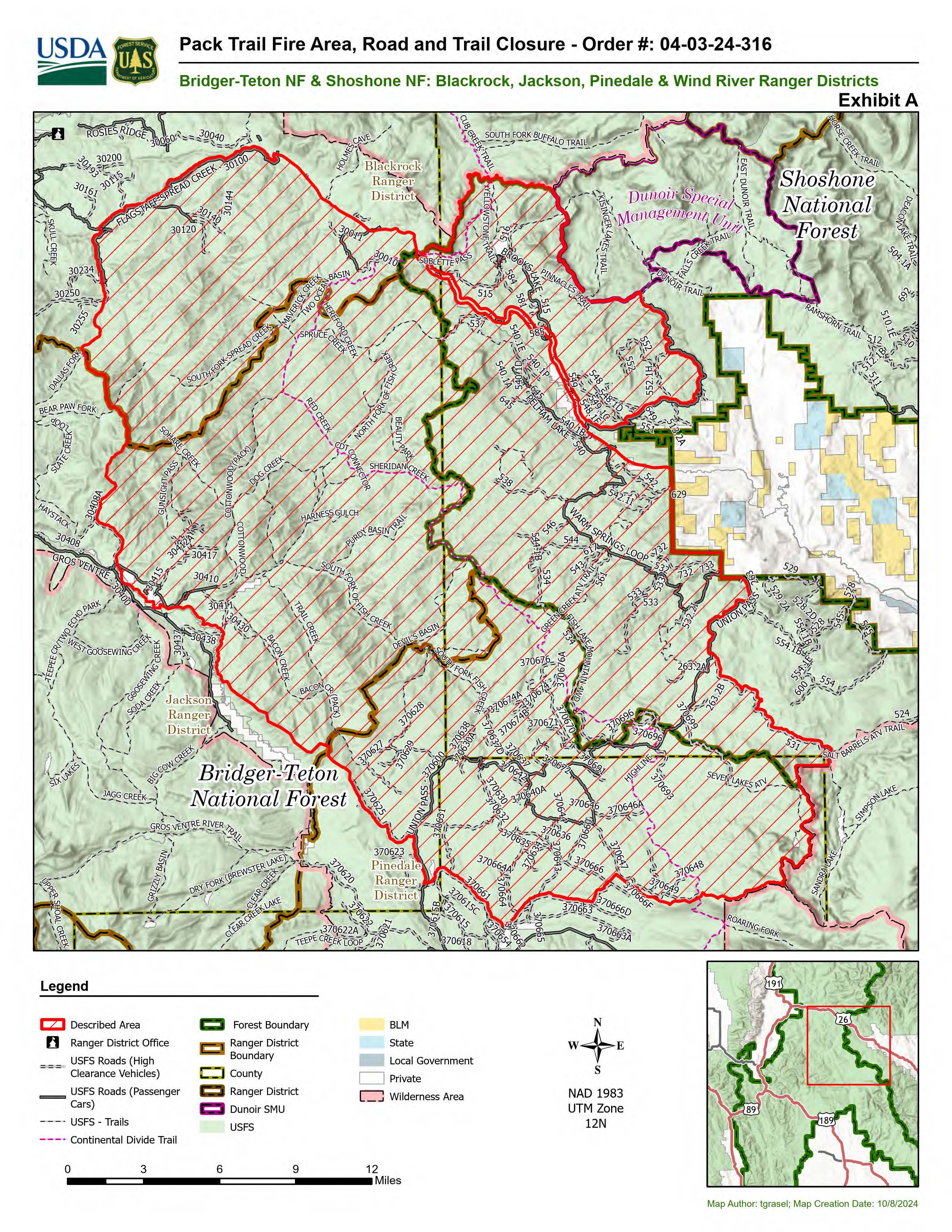
Forest Closures - Closure Order #04-03-24-315 is in effect from October 7 at 12:00 p.m. through November 1, 2024 at 6:00 a.m. unless rescinded. This order supersedes previous orders, including #04-03-24-314, prohibiting the same or similar acts in the same described area. Click here to access the closure order and map on InciWeb.
Evacuations – The Upper Gros Ventre area (Goosewing and Elk Track Ranches) in Teton County have been put into a Level 2 “Set” Evacuation Warning. Evacuations and evacuation alerts for several subdivisions and ranches in Fremont County, WY remain in place. See the Fremont County Emergency Management Fackbook Page for alerts and updates. See the Teton County Emergency Management website updates and to sign up for emergency alerts through Everbridge.
RailroadDaly Fire Update 10 07 2024
Related Incident:
Publication Type: News
Railroad-Daly Fire
Bitterroot National Forest
Fire Information: 458-218-2328
2024.dalyrailroad@firenet.gov
https://linktr.ee/sharrottjohnsondalyrailroad
October 7, 2024
Type 3 Incident Command Team, Incident Commander Matt Young
Location: Railroad Creek/ Skalkaho Creek confluence, 26 miles southeast of Hamilton
Start Date: 7/25/2024
Cause: Undetermined
Daly Fire Acres: 8,254 Railroad Fire Acres: 1,290 Completion: 56%
Total Personnel: 120
Current Status
Yesterday the northeastern part of the fire showed slow movement along the main edge, with some areas burning unevenly. In the upper Stony Creek area, the fire spread slowly but did not grow significantly. The western side produced flames moving down the drainage, and some isolated trees catching fire in the Daly Creek area on both sides of Highway 38.
Crews will continue working on creating a shaded fuel break along Coal Creek Road to Stony Creek. They will also enhance fire protection measures in Stony Creek and keep a close watch on fire activity in the upper Stony Creek area. Additionally, more teams will be building hand and dozer lines from Gird Creek Road to Highway 38. Aerial resources will remain active to monitor and manage the spread of the fire.
Weather and Fire Behavior
In the coming days, we can expect elevated atmospheric pressure, resulting in seasonal temperatures and dry conditions. Nights will be notably cold and consistent, while afternoons and early evenings may experience breezy conditions, which could contribute to increased fire activity.
Fire activity and potential will remain high for at least two weeks due to current and forecasted weather. In the West, burn periods will be longer than usual, especially during wind events. The Great Lakes may see increased fire potential as leaf fall rises, with little precipitation expected. Anomalously dry conditions in the West will heighten fire activity in October, with significant fire behavior during wind events potentially resembling August's intensity, including long burn periods.
EVACUATIONS, RESTRICTIONS, CLOSURES
All areas along State Highway 38 (Skalkaho Highway) starting at mile marker 26.5 near Skalkaho Pass, turning north at the junction with Rock Creek Road (County Road 102), and continuing to the junction of State Highway 348 and Rock Creek Road. From there, it proceeds northwesterly on Rock Creek Road to USFS Road 241 (Stony Creek Road), moving southwest to the junction of Little Stony Creek and Stony Creek. Following Little Stony Creek west to the ridge where Trail 313 (Bitterroot Rock Creek Divide Trail) begins and continuing south along Trail 313 to the intersection with State Highway 38.
New Pack Trail Fire Area Road and Trail Closure Order Effective Wednesday October 9 2024 10 09 2024
Related Incident:
Publication Type: Closures
A new Pack Trail Fire Area, Road, and Trail Closure Order (order # 04-03-24-316) was issued by the Forest Service this afternoon, Wednesday, October 9. This order is in effect from October 9, 2024, at 12:00 P.M. through November 1, 2024, at 6:00 A.M., unless rescinded.
Wapiti and Frog Fires Daily Update 10 07 2024
Related Incident:
Publication Type: News
Wapiti Fire: Location: near Grandjean, ID. Reported: July 24, 2024, Cause: Lightning. Size: 126,817 acres, Completion: 80%, Total Personnel: 186.
Frog Fire: Location: east of Clayton, ID. Reported: September 7, 2024, Cause: Lightning. Size: 3,020 acres, Containment: 87%, Total Personnel: 34.
Weather: Today’s winds are expected to be lighter than they were yesterday, with gusts around 10 -15 mph in exposed terrain. It will be a little drier, and temperatures will be a few degrees warmer. (60s and 70s in the fire areas.) Clouds and winds will increase a bit tonight and tomorrow, but little rain is expected.
Current Situation: Yesterday, increased fire activity was apparent on both the Wapiti and the Frog Fires, producing smoke in several interior areas, but not threatening containment lines. Increased smoke also showed an uptick in fire activity in the Sawtooth Wilderness, the southeast corner of the Wapiti Fire, where the fire is burning through isolated timber stringers in very rugged and inaccessible terrain.
While firefighters have completed most suppression and repair activities, today crews will be working in several areas on both the Wapiti and the Frog Fires. Engine and hand crews will patrol containment lines and use helicopters to monitor internal fire activity. A Wildland Fire module will work on the Frog Fire, maintaining containment lines in the northeast part of the fire, and searching for the heat signature found by an infrared flight in the Red Ridge area. On the Wapiti Fire, a task force will be in the Grandjean area to remove hazardous trees and debris, restore access to the Sourdough area, and monitor the area. Firefighters will continue to remove fire-weakened hazard trees, or “snags” and clearing debris in the fire area on several closed Forest Service roads including Stanely Lake road and along Hwy 21.
Evacuations: Evacuation status for Stanley Zone 1 is currently at READY. Sign up for Custer County CodeRED emergency notifications: text CUSTER to 99411 or enroll at https://public.coderedweb.com/CNE/BF28E45537FF. You can sign up for Boise County Alert Sense emergency notifications at https://public.alertsense.com/SignUp/publicUser.aspx?regionid=1163. For more evacuation information on the Wapiti Fire, please see the Custer County Sheriff’s Facebook page, https://www.facebook.com/p/Custer-County-Sheriff-Idaho-61558947312289/, and the Boise County Sheriff’s Facebook page, https://www.facebook.com/boisecountysheriff/.
Closures: Please reference the map and description at https://inciweb.wildfire.gov/incident-closures/idbof-wapiti-fire. Many trails remain closed for public safety. The Wapiti Fire area closure, which covers portions of the Sawtooth, Boise, and Salmon-Challis National Forests was reduced on the southern end, excluding the Lowman, Ten Ax, Two Raven, and Sourdough communities. An interactive map for all closures on the Boise National Forest is found at https://experience.arcgis.com/experience/642380b0eb124c8cab6bd9ad3d7146ad/page/Overview/#data_s=id%3AdataSource_5-1888bd00a2c-layer-13-1888bd00b53-layer-16%3A82. The area closure in place around the Frog Fire includes FS 667 (Big Boulder Creek Road) and Trail 047 where it is adjacent to the closure boundary. The closure excludes FS Roads 669 and 670 and Trail 682. Please reference the map and read the full closure description at https://inciweb.wildfire.gov/incident-closures/idstf-frog.
Frog Fire Daily Update 10 07 2024
Related Incident: Frog
Publication Type: News
Frog Fire: Location: east of Clayton, ID. Reported: September 7, 2024, Cause: Lightning. Size: 3,020 acres, Containment: 87%, Total Personnel: 34.
Weather: Today’s winds are expected to be lighter than they were yesterday, with gusts around 10 -15 mph in exposed terrain. It will be a little drier, and temperatures will be a few degrees warmer. (60s and 70s in the fire areas.) Clouds and winds will increase a bit tonight and tomorrow, but little rain is expected.
Current Situation: Yesterday, increased fire activity was apparent on both the Wapiti and the Frog Fires, producing smoke in several interior areas, but not threatening containment lines. Increased smoke also showed an uptick in fire activity in the Sawtooth Wilderness, the southeast corner of the Wapiti Fire, where the fire is burning through isolated timber stringers in very rugged and inaccessible terrain.
While firefighters have completed most suppression and repair activities, today crews will be working in several areas on both the Wapiti and the Frog Fires. Engine and hand crews will patrol containment lines and use helicopters to monitor internal fire activity. A Wildland Fire module will work on the Frog Fire, maintaining containment lines in the northeast part of the fire, and searching for the heat signature found by an infrared flight in the Red Ridge area. On the Wapiti Fire, a task force will be in the Grandjean area to remove hazardous trees and debris, restore access to the Sourdough area, and monitor the area. Firefighters will continue to remove fire-weakened hazard trees, or “snags” and clearing debris in the fire area on several closed Forest Service roads including Stanely Lake road and along Hwy 21.
Evacuations: Evacuation status for Stanley Zone 1 is currently at READY. Sign up for Custer County CodeRED emergency notifications: text CUSTER to 99411 or enroll at https://public.coderedweb.com/CNE/BF28E45537FF. You can sign up for Boise County Alert Sense emergency notifications at https://public.alertsense.com/SignUp/publicUser.aspx?regionid=1163. For more evacuation information on the Wapiti Fire, please see the Custer County Sheriff’s Facebook page, https://www.facebook.com/p/Custer-County-Sheriff-Idaho-61558947312289/, and the Boise County Sheriff’s Facebook page, https://www.facebook.com/boisecountysheriff/.
Closures: Please reference the map and description at https://inciweb.wildfire.gov/incident-closures/idbof-wapiti-fire. Many trails remain closed for public safety. The Wapiti Fire area closure, which covers portions of the Sawtooth, Boise, and Salmon-Challis National Forests was reduced on the southern end, excluding the Lowman, Ten Ax, Two Raven, and Sourdough communities. An interactive map for all closures on the Boise National Forest is found at https://experience.arcgis.com/experience/642380b0eb124c8cab6bd9ad3d7146ad/page/Overview/#data_s=id%3AdataSource_5-1888bd00a2c-layer-13-1888bd00b53-layer-16%3A82. The area closure in place around the Frog Fire includes FS 667 (Big Boulder Creek Road) and Trail 047 where it is adjacent to the closure boundary. The closure excludes FS Roads 669 and 670 and Trail 682. Please reference the map and read the full closure description at https://inciweb.wildfire.gov/incident-closures/idstf-frog.
Lava Fire Daily Update 10 07 2024
Related Incident:
Publication Type: News
Persistent heat exists within the fire interior. Increased fire activity has been observed inside containment lines. The fire will continue to smolder and creep within the existing perimeter, consuming available fuels. With this slightly increased fire behavior, increased smoke production has been observed west of Lake Cascade. Smoke production will continue within the fire perimeter until significant winter snows fully extinguish remaining heat.
Current Situation:
- The Type 3 Nevada Team 1 will assume command of the fire tonight at 8:00 p.m.
- Crews continue to work on constructing direct line and mopping up heat along the fire’s northeast edge.
- Helicopters delivered 35,000 gallons of water to those crews.
- Work there is in very steep terrain, and crews are building cup trenches to catch burning, rolling debris to prevent the fire from spreading downslope.
- More crews are arriving to join the effort on the northeast area of the fire.
- A UAS was used to identify areas of heat in the Anderson Creek area yesterday. Engine crews will continue to work in this area to mop up hot spots.
- Along the western edge of the fire, crews continued to patrol lines and conduct suppression repair on dozer lines. Road graders are wrapping up road repairs.
- The Utah Type 2 Initial Attack crew will move back to the southeast line today to continue extinguishing areas of heat, working toward Gabes Peak.
Weather: Temperatures will be higher over the fire today, with light winds gusting 10-15 mph. Southwest winds increasing on ridgetops overnight up to 20 mph. Yesterday, the inversion kept smoke low in the Cascade valley until noon. Today the inversion is expected to break around 1:00 p.m.
Evacuations: In Gem County, a Level 1 “READY” notice remains for residents south of South Grays Creek, along Little Weiser River Road in Indian Valley, north of South Grays Creek Road to Highway 95, and the Mesa Area. Learn more at Gem County Sheriff's Office. In Valley County, Zones 4 – 6 remain in a LEVEL 1 “READY” status. Learn more at Valley County Sheriff's Office.
Closures: The Boise and Payette National Forests adjusted the Lava Fire area closure on September 30, increasing access for the public to access areas north and south of the fire perimeter. For updated map and closure information visit Closure areas | Boise National Forest | Facebook.
Road Closures: Third Fork Road at Nesbitt Lane, Second Fork Road at Nesbitt Lane, and Nesbitt Lane. Check out updated Gem County closure information at Gem County Sheriff's Office.
Temporary Flight Restrictions:A temporary flight restriction (TFR) is in effect. View a map of the TFR and details at https://tfr.faa.gov/save_pages/detail_4_8199.html. Fire aviation response is halted or delayed if unauthorized aircrafts, including drones, enter the TFR. If you fly, we can’t! Learn more about how to use drones safely and responsibly at Home - Know Before You Fly.
Fire Info Phone: 208-780-5003 Hours: 7:00 a.m. to 7:00 p.m. Email: 2024.Lava@firenet.gov
Facebook: @LavaFire Inciweb: inciweb.wildfire.gov/incident-information/idbof-lava-fire
Tiger Creek Fire Daily Update 10 06 2024
Related Incident: Tiger Creek Fire
Publication Type: News
Current Situation: The Tiger Creek Fire is currently 475 acres and five percent contained. California Complex Incident Management Team 15, under the leadership of Incident Commander Tom Clemo, has assumed command of the Tiger Creek Fire. Firefighters continue to make good progress constructing handline paying special attention to minimize firefighting impacts on the watershed. Throughout the days crews will continue reinforcing that line while also beginning mop-up operations where appropriate.
On the northern and northeast flank, crews are working to contain several spot fires with the main emphasis of work focusing on the large spot fire east and above Low Creek.
Aviation resources are available and will aid in slowing the fire’s spread with three Type-1 aircraft, one Type-2 aircraft and one Type-3 aircraft assigned to the incident.
Closures and Restrictions: Access through Forest Service Road (FSR) 65 up through FSR 64 to the junction with Indian Camp is closed. Government Mountain Road/FSR 6511 is closed from North Fork Walla Walla trailhead to the junction with FSR 65 at Tiger Saddle. Government Mountain Rd/FSR 6511 is open from the west to North Fork Walla Walla trailhead. The current fire danger rating is MODERATE and public use restrictions phase A for Umatilla National Forest are in effect. For more information regarding restrictions, please contact Umatilla National Forest Toll-free Information Hotline: 1.877.958.9663.
Weather: Weather over the next few days will remain mostly sunny and dry with occasional light wind gusts ranging from 3 to 7 mph on the ridgetops and temperatures topping out in the lower to mid-70s. In the upper elevations, relative humidity will remain unseasonably low ranging from the lower teens to mid-20 percent.
Smoke: Walla Walla’s air quality for today is good and remains steady, some residents along Mill Creek may experience smoke as the fire continues to burn. Check out https://wasmoke.blogspot.com/?m=1 for more information.
Elkhorn Fire Evening Update 10 07 2024
Related Incident: Elkhorn Fire
Publication Type: News
Elkhorn Fire Evening Update - 10/6/2026
Acres: 22,430
Containment: 20%
Update:
Today, the Civil Air Patrol was able to fly the fire and mapped the burn area at 22,430 acres. The North Dakota National Guard (NDNG) utilized a Blackhawk helicopter to perform bucket drops in rugged areas that are difficult to access by vehicle, both on the north side of the fire and at the east end. Additionally, two air tanker fire retardant drops took place on the north side of the fire. Some mop up work was started as well.
Crews assigned to the south side of the fire were able to keep the fire north of County Road 34 and stopped much of the fire’s movement toward the east.
Tomorrow, the NDNG will be back with the Blackhawk. Work will continue on the north side of the fire in the Rough Creek drainage along Road 8562. “Favorable weather conditions over the next couple of days will aid firefighters in continuing progress with containment of the fire,” said Dave Uhlich, Fire Chief of the Watford City Fire Department.
The Little Missouri National Grassland would like to say Thank You to the all the cooperators and knowledgeable landowners who have been working alongside us in this endeavor.
Available Resources:
- If you are missing livestock in the aftermath of this or other recent fires in western ND, please contact the North Dakota Stockmen’s Association at (701) 595-2421 (chief brand inspector), (701) 214-7709 (executive vice president) or (701) 223-2522 (office) or by emailing cward@ndstockmen.org or jellingson@ndstockmen.org to file a missing livestock report.
- Stress and Mental Health Resources: https://www.ndsu.edu/.../farm-safety-health/managing-stress
- Call 988 Suicide and Crisis Lifeline – www.hhs.nd.gov/988
Yellow Lake Fire Evening Post 10 06 2024
Related Incident: Yellow Lake Fire
Publication Type: News
The Yellow Lake Fire continues to burn and is now mapped at 15,891 acres with 7% containment. No contained perimeter has been lost in the past few days, but the containment percentage decreased due to the increase in acreage. Currently, 459 personnel are assigned to the fire.
Clear skies allowed for a more accurate infrared reading, helping gauge the fire's growth over the past two days of strong winds. The fire has expanded along most of the uncontained perimeter. Slightly reduced winds in the morning allowed smoke to settle in the valley, temporarily slowing the fire's spread. However, by the afternoon, winds picked up, increasing fire activity.
Crews focused on structure protection and strengthening infrastructure where conditions allowed. Controlled burns were used to reduce fuel between the fire and containment lines, helping lower the fire's intensity and making it more manageable. Crews are working on containment, particularly at the fire's heel and flanks.
The fire spotted into Heart Lake, and continues to move in a southeastern direction. Today crews were able to get into the region, and use helicopters to cool the spots but the spots continue to remain active. Crews are holding the line at Mill Hollow Road, continuing controlled burns to limit fuel.
With improved weather, aircraft were able to drop water and retardant on hot spots. The number of aircraft resources has been increased to six.
Mandatory evacuation orders remain in place for the North and West Forks of the Duchesne River. Those in the Granddaddy Lakes region of the Ashley National Forest and Hanna remain in READY status, meaning they should be packed and ready to evacuate if necessary.
We remind residents, hunters, and recreationists to stay out of evacuated areas for the safety of everyone, including firefighters and first responders. Thank you to everyone who has followed the evacuation orders.