
Line Fire Daily Facts Sheet for 10 07 2024
Related Incident: Line Fire
Publication Type: News
Current Situation:
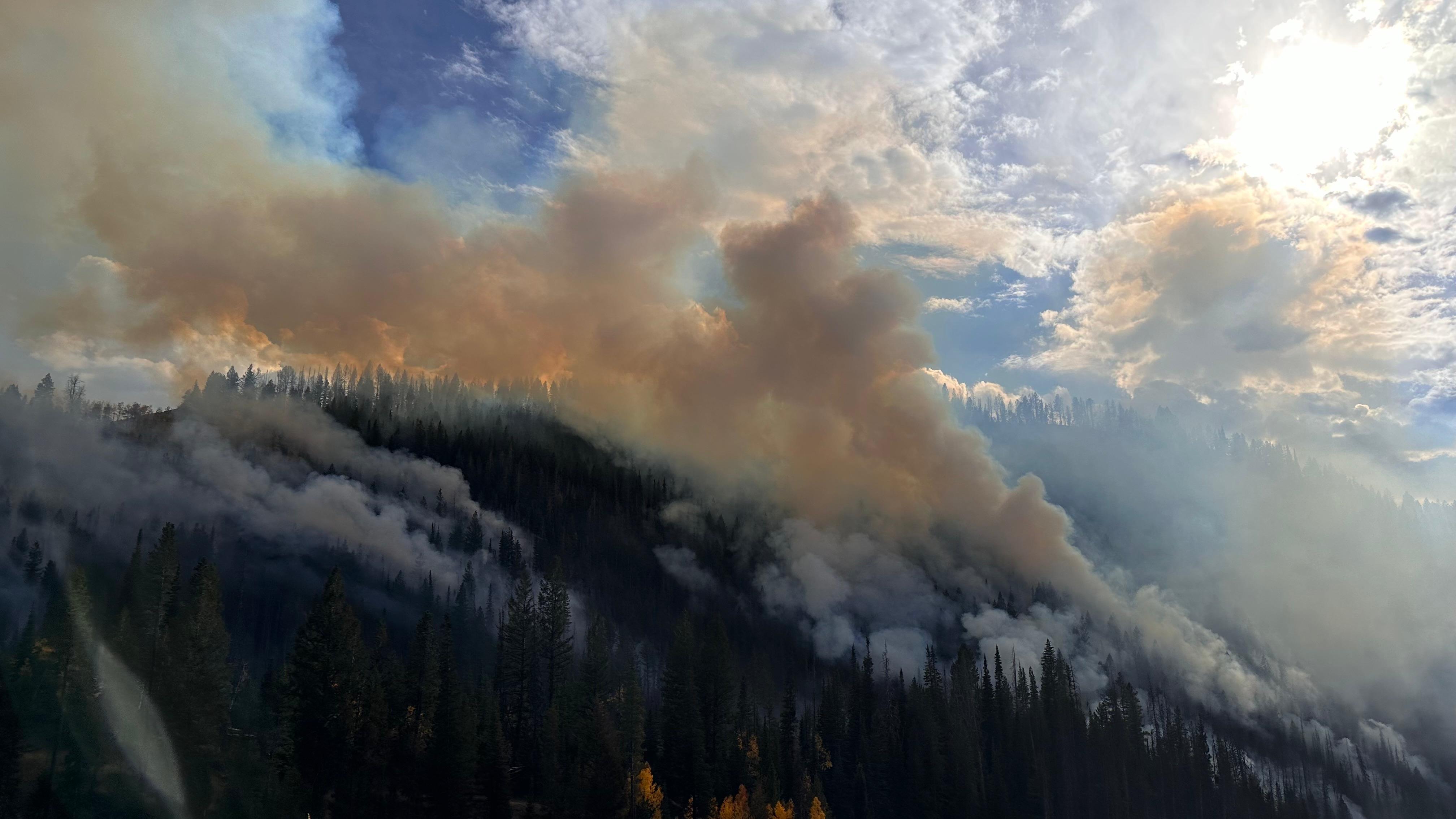
Some smoke will continue north of Angelus Oaks for a few days as a green island is consumed. Crews are engaged, and there is no concern. Smoke seen from the Arctic Circle is coming from two ridges back where there is still some heat, but no threat to the line. Demobilization of some crews and resources will be happening over the next few days. Crews that remain will be working on suppression repair, as well as direct and indirect line construction.
Higher than average temperatures continue throughout today, with temperatures starting to drop tomorrow. Fire behavior will remain challenging throughout the week with stronger afternoon winds, with gusts reaching near 22 mph. With the continued dry heat, the fire area is under a Fuels and Fire Behavior Advisory, with low overnight humidity further drying out fuels. The main challenge in these conditions continues to be focused around Angelus Oaks off Highway 38, with additional concerns south of Big Bear near Mile Creek and in the Santa Ana River drainage. Inaccessible areas at the confluence of Bear and Siberia Creeks are susceptible to slope reversals due to the continuing dry, hot weather patterns.
Evacuation orders remain in place for the Barton Flats, Pinezanita and Seven Oaks communities. Evacuation warnings are still in effect for the Angelus Oaks area.
Highway 330 remains closed from Highland Avenue to Highway 18 as CalTrans performs repairs to the road and guardrails. Highway 38 is still closed from Angelus Oaks to Lake Williams.
The closure orders for the San Bernardino National Forest remain in place.
Public information line: 909.220.4292
Media Line: 925.542.9164
Yellow Lake Fire Evening Update 10 07 2024
Related Incident: Yellow Lake Fire
Publication Type: News
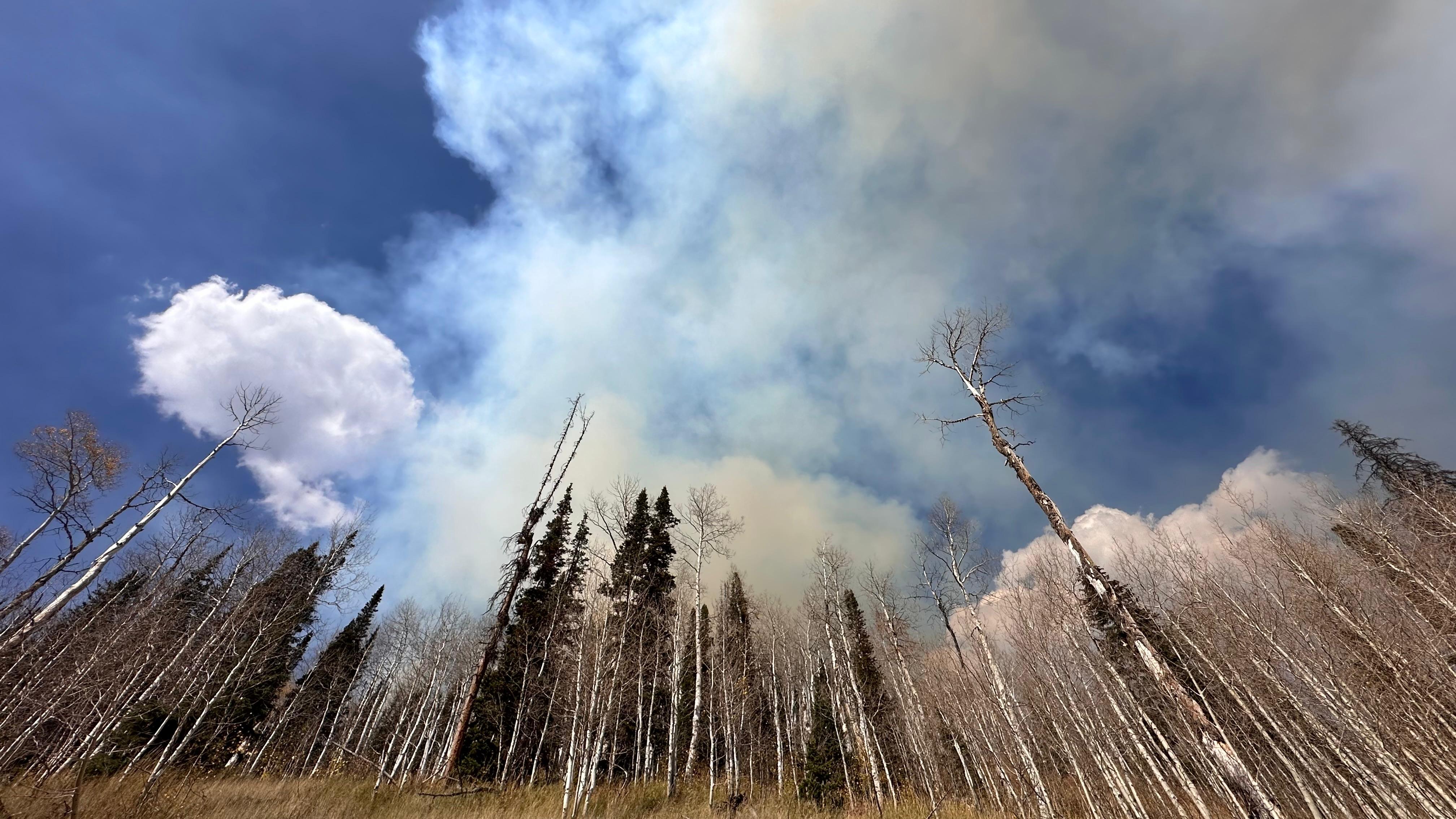
The #YellowLakeFire remained very active today and remains at 10% containment. It has burned an estimated 19,000 acres, with a more accurate acreage expected tomorrow morning after the planned infrared flight tonight.
Where fire behavior safely allows, firefighters continue to work diligently towards adding containment to the map and slowing the fire's progression. Crews are mopping up and securing the perimeter that has already been contained or close to containment on the south and west sides. The Mill Hollow Road and Soapstone area have seen little growth throughout the day.
Structure protection remains a high priority. The northeast corner activity picked up in the Iron Mine drainage, and crews will work overnight in this area to protect the structures. Currently no structures have been lost.
Firefighters are utilizing fixed wing and rotor wing support where successful. Along Highway 35, firing operations were also conducted to consume unburned fuels between the current fire perimeter and indirect firelines.
Due to the long duration of the incident, a Complex Incident Management Team (CIMT) has been ordered and will shadow the Northern Utah Type 3 Incident Management Team tomorrow. The CIMT will take command of the fire Wednesday morning.
Evacuations and forest closure remain the same.
Frog Fire Area Closure Order and Map 10 07 2024
Related Incident: Frog
Publication Type: Closures
PROHIBITIONS
Pursuant to 16 U.S.C. § 551 and 36 C.F.R. § 261.50 (a) and (b), the following are prohibited on the National Forest System (NFS) lands in the Sawtooth National Forest, Sawtooth National Recreation Area, described below and shown on the attached map incorporated into this Order as Exhibit A (the “Described Area):
- Going into or being upon the Described Area. 36 C.F.R. § 261.52(e).
EXEMPTIONS
Pursuant to 36 C.F.R. § 261.50(e), the following persons are exempt from this Order:
- Persons with Forest Service Permit No. FS-7700-48 (Permit for Use of Roads, Trails, or Areas Restricted by Regulation or Order), specifically exempting them from this Order or a written determination by a Forest Service authorized officer that a permit is not required under 36 C.F.R. § 251.50(e)(1) or (2).
- Any Federal, State, or Local Officer, or member of an organized rescue or firefighting force in the performance of an official duty.
- Federal or State administrative personnel in the performance of an official duty.
DESCRIBED AREA
The Described Area is all NFS lands within the following boundaries:
- Beginning at the junction of the Sawtooth National Recreation Area boundary and Big Boulder Road FS #667 Section 9, Township 9 North, Range 17 East;
- Continuing west along but excluding Big Boulder Road FS #667 to the junction with the Big Boulder Trailhead in Section 6, Township 9 North, Range 17 East;
Continuing south along but excluding the Livingston Mill-Castle Divide Trail, NFS Trail #047, to the junction of the Little Boulder Trail #682 Section 35, Township 9 North, Range 16 East;
- Continuing east along but excluding Little Boulder Trail #682 to the intersection with the Sawtooth National Recreation Area boundary in Section 29, Township 9 North, Range 17 East;
Continuing northeast along the Sawtooth National Recreation Area boundary and ending at its junction with the Big Boulder Road FS #667, in Section 9, Township 9 North, Range 17 East, Boise Meridian.
The Described Area is located in Custer County, Idaho.
The following roads and trails bordering the Described Area are open: Forest Road #667 and NFS Trails 047 and 682.
PURPOSE
The purpose of this Order is to protect public safety during the Frog Fire.
IMPLEMENTATION
- This Order shall be in effect from October 7th, 2024 at 6:00 p.m. through December 31, 2024, at 11:59 p.m., unless rescinded.
A map identifying the Described Area is attached and made part of this Order as Exhibit A. For a digital version of this Order and Exhibit A, go to
https://www.fs.usda.gov/alerts/sawtooth/alerts-notices
- Unless otherwise expressly defined in this Order, the terms used in this Order are defined by the regulations of the Secretary of Agriculture, 36 C.F.R. Chapter II, Parts 200-299. If there are terms in this Order that are not expressly defined in the Order or 36 C.F.R. Chapter II, Parts 200-299, their meaning shall be determined by their plain language definitions.
- A violation of the above prohibitions is punishable as a Class B misdemeanor by a fine of not more than $5,000 for individuals and $10,000 for organizations, or by imprisonment for not more than six months, or both. 16 U.S.C. § 551; 18
U.S.C. §§ 3559, 3571, and 3581.
- Contact the Sawtooth National Recreation Area office in Ketchum, ID, (208) 727- 5000, or the Sawtooth National Forest Supervisor’s Office in Jerome, ID, (208) 423-7500, for more information about this Order.
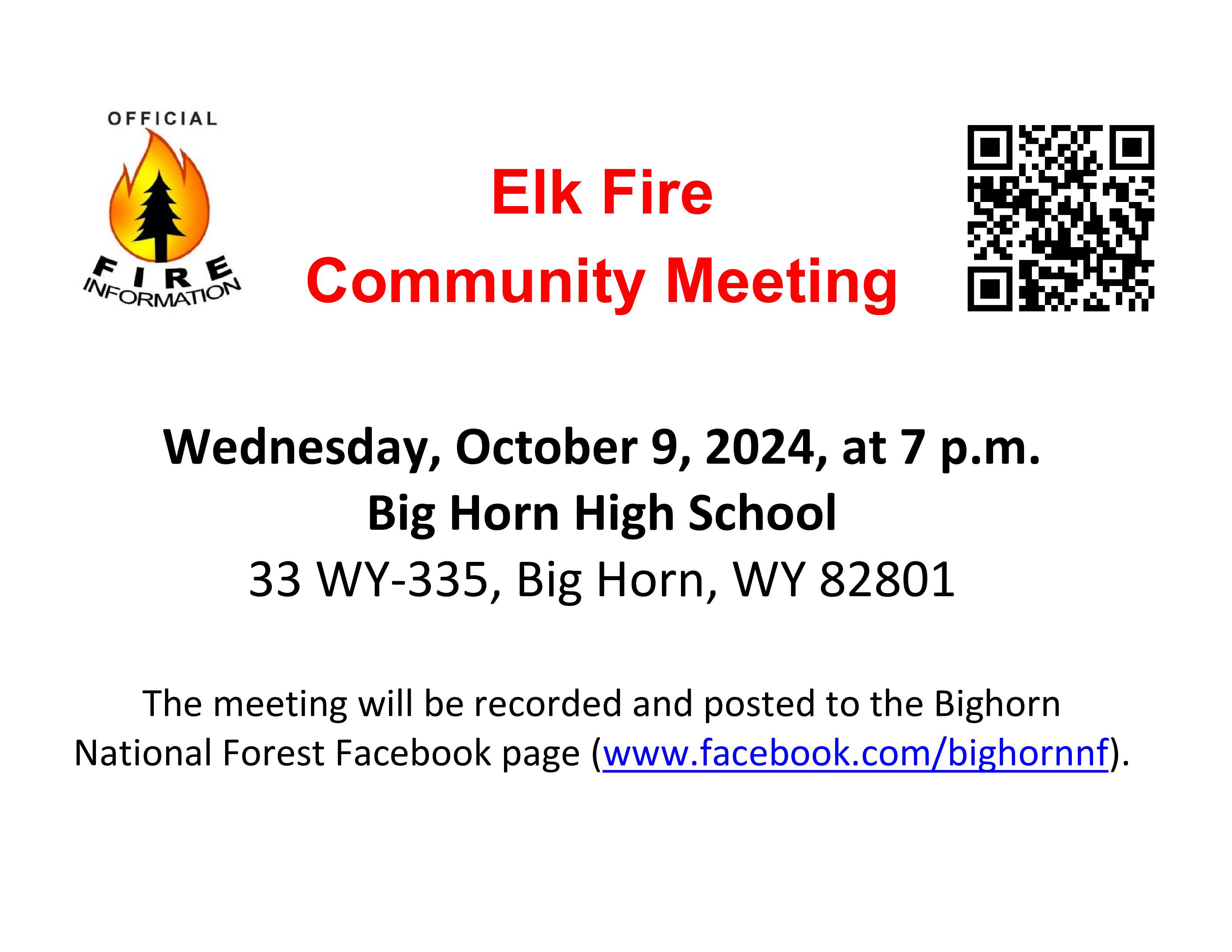
Elk Fire Community Meeting Planned for October 9 10 09 2024
Related Incident: Elk Fire 2024
Publication Type: Announcement
There will be a meeting for the communities of Big Horn and Story on Wednesday, October 9 at 7:00 p.m. at the Big Horn High School.
Settings - change map background and toggle additional layers
Filter - control incident types displayed on map.
Zoom to your location
Reset map zoom and position
Could not determine your location.
Show Legend
 Wildfire
 Prescribed Fire
 Burned Area
Response
Burned Area
Response Other
Other
2024 Valley Fire
Unit Information
Incident Contacts
KXGV Radio Show Oct 7 2024 10 07 2024
Related Incident:
Publication Type: Announcement
KXGV Community Radio Interview with Randy Lamb, Operations Section Chief (T), Great Basin Team 6
Fire personnel will be concentrating their efforts on the Goat Fire today, using a drone and ground resources to conduct a burn out north of the Silver Creek Plunge area. The operation is expected to last several days as they shepherd the fire towards the forest roads they are using as control features. The intent is to stop any further movement of the fire towards Boiling Springs and Silver Creek by removing fuel while conditions remain moderate. While the fire did see significant growth during the wind event on Friday, conditions have calmed over the weekend. On the northeast corner of the fire near Warm Lake, fire behavior was also very light over the weekend. Crews there continue to mop-up at the fire's edge in the area around the Yellow Jacket Creek Trail Bridge. They have also completed structure protection at the Stolle Guard Station and Juniper Mountain Outfitters and are assessing structures in the Warm Lake area in case the fire moves further north. Operations Section Chief Randy Lamb gave an update early this morning to Garden Valley Community Radio KXGV LP 98.5 FM and highlights of that conversation are in this video. Although some hot spots in the Snag and Nellie Fire areas did show themselves during the wind Friday, they have either been mopped up or are well within the fire perimeter. Fire maps can be downloaded at the fire Inciweb page: Idbof Middle Fork Complex Fire Bulldog And Nellie - | InciWeb (wildfire.gov)
Tiger Creek Fire Daily Update 10 07 2024
Related Incident: Tiger Creek Fire
Publication Type: News
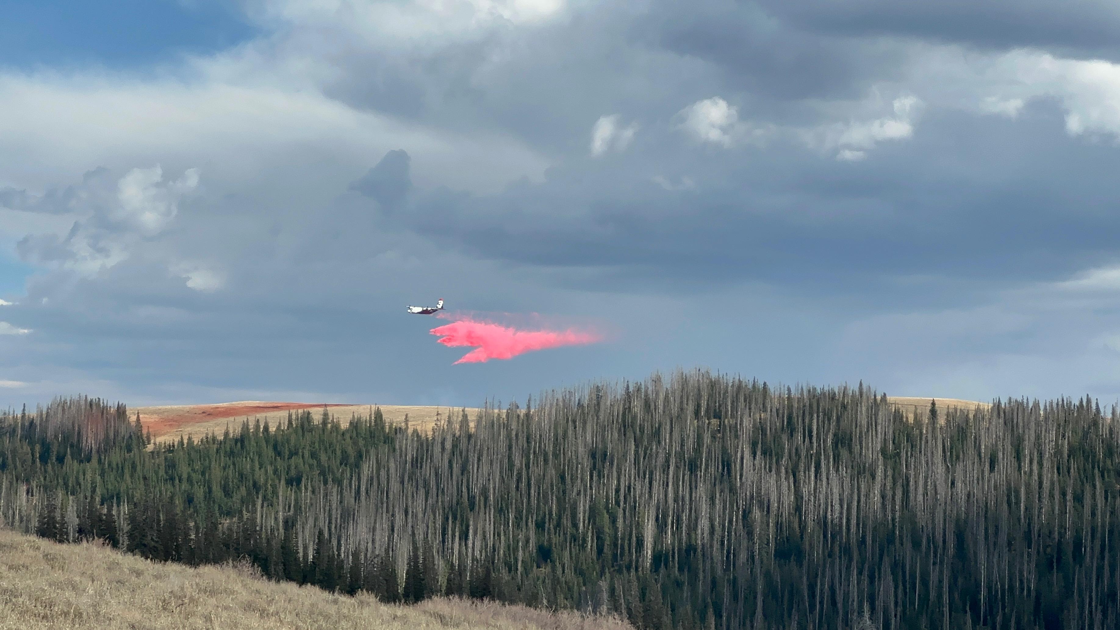
Current Situation: The Tiger Creek Fire is currently 611 acres, seven percent contained with 341 firefighting resources assigned. Poor overnight relative humidity recoveries in the mid-elevations continue to plague firefighting efforts exacerbated by lower-than-normal relative humidity during the day. Aviation assets located a 50 x 50-foot spot fire east of the 65 road and were able to immediately drop water on it allowing crews the opportunity to contain it. On the fire’s northern flank work will continue to build and improve handlines, working to tie-in the line around the northeast flank of the fire below Low Ridge. Closer to the 65 Road on the fire’s eastern flank, hotshot crews continue to cut line around the spot fire, now estimated at 120 acres burning within the Low Creek drainage. Crews have successfully placed hose-lays into the lower portion of Tiger Creek as the fire slowly backs down toward the municipal water system.
The lack of fire history within the area has resulted in a large component of dead surface fuels in the understory. Fuels and terrain are extreme in some locations and pose significant challenges for holding actions. Due to fuels, winds, steep slopes, and lack of natural control features within the area, the potential for fire growth is moderate. Fuel types within the area are burning readily during daytime burn periods when conditions align.
Aviation resources are available and will aid in slowing the fire’s spread with four Type-1 aircraft, one Type-2 aircraft and one Type-3 aircraft assigned to the incident.
Closures and Restrictions: Access through Forest Service Road (FSR) 65 up through FSR 64 to the junction with Indian Camp is closed. Government Mountain Road/FSR 6511 is closed from North Fork Walla Walla trailhead to the junction with FSR 65 at Tiger Saddle. Government Mountain Rd/FSR 6511 is open from the west to North Fork Walla Walla trailhead. The current fire danger rating is MODERATE and public use restrictions phase A for Umatilla National Forest are in effect. For more information regarding restrictions, please contact Umatilla National Forest Toll-free Information Hotline: 1.877.958.9663.
Weather: Sunny with highs in the mid-60s to lower 70s and afternoon humidity around 20-30%. Light upslope winds will develop in terrain around 1000 with ridgetop winds from the south-southwest 3-7 mph with gusts around 10 mph. Clear tonight. Lows in the lower 40s to lower 50s in the thermal belt (4500-5000 feet elevation). Excellent humidity recovery at lower elevations with poor recovery in the thermal belt. Light winds from the south along ridgetops. Winds in terrain will be light and downslope. Broad, weak high pressure lingering over the Pacific Northwest today will shift east by tomorrow. Skies remain clear into Tuesday followed by a gradual increase in clouds Tuesday afternoon and evening.
Smoke: Walla Walla’s air quality for today is good and remains steady, some residents along Mill Creek may experience smoke as the fire continues to burn. Check out https://wasmoke.blogspot.com/?m=1 for more information.
Line Fire Fact Sheet 10 07 2024
Related Incident: Line Fire
Publication Type: News
Current Situation:
Some smoke will continue north of Angelus Oaks for a few days as a green island is consumed. Crews are engaged, and there is no concern. Smoke seen from the Arctic Circle is coming from two ridges back where there is still some heat, but no threat to the line. Demobilization of some crews and resources will be happening over the next few days. Crews that remain will be working on suppression repair, as well as direct and indirect line construction.
Higher than average temperatures continue throughout today, with temperatures starting to drop tomorrow. Fire behavior will remain challenging throughout the week with stronger afternoon winds, with gusts reaching near 22 mph. With the continued dry heat, the fire area is under a Fuels and Fire Behavior Advisory, with low overnight humidity further drying out fuels. The main challenge in these conditions continues to be focused around Angelus Oaks off Highway 38, with additional concerns south of Big Bear near Mile Creek and in the Santa Ana River drainage. Inaccessible areas at the confluence of Bear and Siberia Creeks are susceptible to slope reversals due to the continuing dry, hot weather patterns.
Evacuation orders remain in place for the Barton Flats, Pinezanita and Seven Oaks communities. Evacuation warnings are still in effect for the Angelus Oaks area.
Highway 330 remains closed from Highland Avenue to Highway 18 as CalTrans performs repairs to the road and guardrails. Highway 38 is still closed from Angelus Oaks to Lake Williams.
The closure orders for the San Bernardino National Forest remain in place.
Public information line: 909.220.4292
Media Line: 925.542.9164
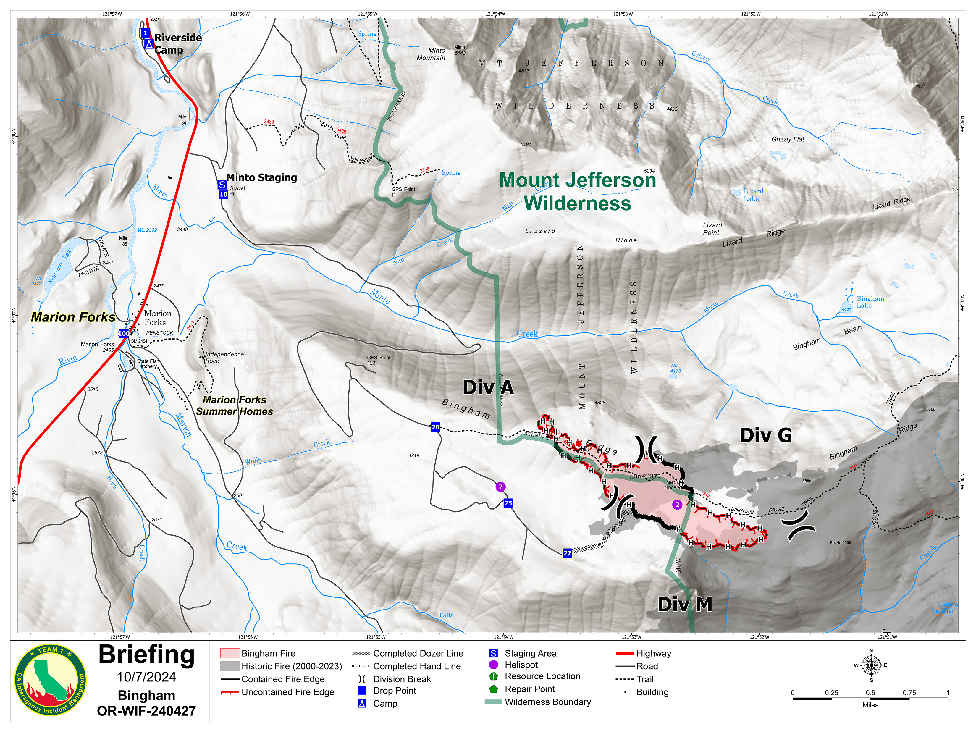
Bingham Fire Daily Update for Monday October 7 2024 10 07 2024
Related Incident: Bingham Fire
Publication Type: News
Containment grows to 23% in Bingham Fire
Daily Update: October 7, 2024
Fire Information Phone: 503-854-3366 (8 a.m.-8 p.m.)
Email: 2024.Bingham@firenet.gov
Acres: 183 Containment: 23%
Location: Areas of the Mount Jefferson Wilderness, east of Marion Forks.
Start Date: September 30,2024 Personnel: 308
Resources: 9 crews | 11 engines | 1 bulldozer | 2 water tenders |
Highlights: The Bingham Fire remained at 183 acres, but containment grew to 23 percent as firefighters secured segments along the southern and northern portions of the fire. Crews also completed digging containment lines around the fire’s entire 4.4-mile perimeter. These lines, however, are not considered fully contained until they are widened and nearby heat sources extinguished, giving fire managers greater confidence that flames won’t spread outside of them.
Firefighters will focus efforts today widening containment lines and identifying nearby hot spots. Progress will be slow, however, as crews negotiate working amid an abundance of standing dead trees killed by previous wildfires 10 to 15 years earlier, making the trees particularly dangerous as a falling hazard.
Crews also will continue work on contingency containment lines near the community of Marion Forks, which is situated about 2 miles northwest of the fire’s western boundary. Work will include removing dead or hazardous trees along Marion Creek Road (NFS Road 2255) that could block access or escape or even cause injury to homeowners or other motorists visiting the area.
Evacuations: LEVEL 3: GO NOW! evacuation alerts have been issued by the Linn County Sheriff’s Office for a large area of the Mount Jefferson Wilderness. Additionally, LEVEL 2: GET SET evacuation alerts have been issued for the area around Marion Forks Campground and Marion Forks Fish Hatchery. The Level 2 evacuation area also extends along Highway 22, to a ½-mile west of Highway 22, from Pamelia Road (NFS Road 2246) south to Parrish Lake Road (NFS Road 2266). Please refer to the Linn County Wildfire Map for more information: https://tinyurl.com/LinnCoFireMap. Highway 22 remains open at this time.
The Willamette National Forest issued an updated formal closure Oct. 4 in the same footprint of the Level 3 Evacuation here: https://tinyurl.com/26jpr9a6. A large evacuation area like this is necessary to give wildfire response teams enough space to safely travel to and fight the fire as crews will be on road systems and trails and air assets may be utilizing nearby water sources. The fire itself is much smaller than the evacuation area. The Pacific Crest Trail through the Mount Jefferson Wilderness is expected to remain open. The trails and roads west of the highway are closed from Pamelia to Big Meadows Loop/Turpentine Loop area. With hunting season started, Forest Service staff will work with the Linn County Sheriff’s Office to reduce closure areas as soon as it is safe to do so.
Weather: Temperatures are forecasted to climb into the upper 70s today, but expected to fall back into the 60s by Tuesday. A 10 percent chance of rain is expected by Tuesday or Wednesday.
FIRE SUMMARY OCTOBER 7 2024 10 07 2024
Related Incident:
Publication Type: News
There have been no new fires reported on the Salmon-Challis National Forest since the last update on Monday, September 30, 2024. To date, there have been 64 wildfires reported on the Salmon-Challis National Forest. 53 of the fires have been declared out.
Mowitch (September 29): is approximately three (3) miles north of Indian Creek on the Middle Fork Ranger District in the Frank Church River of No Return Wilderness. The 993 acre fire is burning in grass, brush, spruce, fir, and ponderosa pine. The fire can be found on InciWeb at https://inciweb.wildfire.gov/incident-information/idscf-mowitch-fire.
Nugget (September 13): is located approximately 40 miles west of Salmon on the North Fork Ranger District in the Frank Church River of No Return Wilderness. The 994 acre fire is burning in fir. The fire is surrounded by and in fire scars from 2005, 2013, and 2015. Fire managers are recommending the public do not enter the Nugget and Cradle Creek drainages. The fire can be found on InciWeb at https://inciweb.wildfire.gov/incident-information/idscf-nugget-fire.
Garden (September 8): is located approximately two (2) miles southwest of the confluence of Panther Creek and the Main Salmon River on the North Fork Ranger District in the Frank Church River of No Return Wilderness. The fire is approximately 7,186 acres burning in grass, brush, and timber. The fire is being managed by a local Type III organization and is being reported separately. The fire can be found on InciWeb at https://inciweb.wildfire.gov/incident-information/idscf-garden-fire.
Vanity (September 3): is located approximately 42 miles west of Challis on the Middle Fork Ranger District. The approximately 600 acre fire is burning in subalpine fir and is surrounded by the 2012 Halstead Fire. Fire managers are using a point protection strategy (a wildfire response strategy, which protects specific assets or highly valued resources from the wildfire without directly halting the continued spread of the wildfire) to minimize exposure to fire personnel while protecting identified values. Specific values potentially threatened with this fire include Forest Service infrastructure. The fire can be found on InciWeb at https://inciweb.wildfire.gov/incident-information/idscf-vanity.
Red Rock (September 2): is located approximately two (2) miles east of Yellowjacket Guard Station on the Salmon-Cobalt Ranger District. The Red Rock Fire experienced extreme fire behavior on October 4 due to the passing wind event with gusts up to 56 miles per hour recorded. The Black Eagle fire merged with the Red Rock Fire. The combined fire is now known as the Red Rock Fire and is being reported as such. A Type III Incident Management Team is managing the fire and information is being reported separately. The fire can be found on InciWeb at https://inciweb.wildfire.gov/incident-information/idscf-red-rock-fire.
Reynolds (August 22): is located approximately 21 miles northwest of Indianola, approximately 5.5 miles northwest of Horse Creek Hot Springs Campground on the Idaho/Montana border. Fire is estimated to be approximately 2,671 acres burning in spruce and fir. The Bitterroot National Forest is lead on this fire.
Birch (August 17): is located on the west side of the Middle Fork of the Salmon River on Norton Ridge on the Middle Fork Ranger District in the Frank Church River of No Return Wilderness. The 13,274 acre fire is burning in subalpine fir. The fire is surrounded by the 2022 Norton Fire and fire scars from the fires of 2000. The fire can be found on InciWeb at https://inciweb.wildfire.gov/incident-information/idscf-birch-fire.
Greyhound (August 11): is located approximately 46 miles northwest of Challis on the Middle Fork Ranger District. The 97 acre fire is burning in subalpine fir and lodgepole pine on the edge of the 2021 Boundary Creek Fire. Firefighter and public safety is the number one priority for the Greyhound Fire. During initial size up for the fire, several safety concerns were identified including: the remote location of the fire, steep and inaccessible terrain, heavy dead and down fuels with a substantial snag component, private property and associated mining infrastructure, and lack of safe ingress and egress for firefighters. Fire managers will be monitoring the fire with reconnaissance flights and lookouts.
Black Eagle (August 5): is located approximately 12 miles west of Forney on the North Fork Ranger District in the Frank Church River of No Return Wilderness. The Black Eagle Fire experienced extreme fire behavior on October 4 due to the passing wind event with gusts up to 56 miles per hour recorded. The fire grew to the northeast and merged with the Red Rock Fire. The combined fire is now known as the Red Rock Fire and is being reported as such. A Type III Incident Management Team is managing the fire and information is being reported separately. The fire can be found on InciWeb at https://inciweb.wildfire.gov/incident-information/idscf-red-rock-fire.
Wapiti (July 24): started on the Boise National Forest, burned onto the Sawtooth National, and around August 24th burned onto the Salmon-Challis National Forest. A Complex Incident Management Team is managing the fire. Information can be found on InciWeb at https://inciweb.wildfire.gov/incident-information/idbof-wapiti-fire.
Thunder (July 24): The lightning fire is located approximately two (2) miles northwest of Williams Lake and approximately 12 miles southwest of Salmon. The fire is 100% contained and controlled, fire size is estimated to be 2,474 acres and is burning in timber, sagebrush, and grass.
Weather: Weak westerly flow today will keep skies clear and continue the warming trend, although afternoon humidity should change little. A very weak low will shift wind to more southwesterly starting tonight. This will bring in more cloudiness, but the chance for precipitation is still nearly zero. Wind should peak on Wednesday afternoon with the low passing to the east, bringing slightly colder air for Thursday.
The forest is asking visitors to be aware of the HIGH fire danger for the Salmon-Challis National Forest. Ensure your campfire is dead out. If it is too hot to touch, it is too hot to leave! One Less Spark Means One Less Wildfire. Since June 1, Forest employees have found and extinguished at least 13 abandoned campfires.
Nationally, there are 27 uncontained large fires being managed under a full suppression strategy and 16 large fires managed under a strategy other than full suppression.
Visit our website at: www.fs.usda.gov/scnf/, ‘Like Us’ on Facebook @salmonchallisnf, and ‘Follow Us’ on X @salmonchallisnf.
####
‘USDA is an equal opportunity provider and employer’