
Red Rock Fire Daily Update 10 06 2024
Related Incident:
Publication Type: News
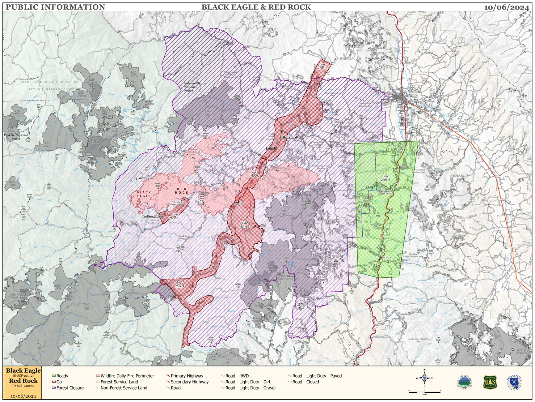
RED ROCK AND BLACK EAGLE FIRES HAVE MERGED AND ARE NOW THE RED ROCK FIRE
FIRE ACTIVITY:
Fire Size: 52,729 acres
Containment: 5%
Both the Red Rock and Black Eagle Fires experienced extreme fire behavior on October 4, 2024, and grew exponentially to the northeast, merging together just north of Yellowjacket. The combined fire is now know as the Red Rock Fire.
Fire crews have reorganized around the new fire footprint and are engaging where safe to do so. New divisions have been created around the new fire perimeter and resources are being assigned to these new dividsions to try and limit further spread. Much of the pre-existing containment line to the south and west held through the wind event and is being used as anchor points for crews to build from. Heavy helicopter support across the fire is slowing fire progression and allowing crews to directly engage the fire’s edge.
Lemhi County Sheriff’s Office is enforcing several evacuation notices for the areas of Panther Creek, Forney, Moyer, Cobalt, Blackbird, and Leesburg. Damage to any structures in these areas is still being assessed. If any structures are identified that have been damaged or destroyed, Lemhi county officials from either the Sheriff’s Office or the Emergency Management Services Office will notify property owners.
Please stay out of the area. There are multiple roads and bridges that have been destroyed or are impassable. Entry into evacuation zones that are in “Go” status is prohibited. The updated forest closure notice that encompasses both the Red Rock Fire and Garden Fire areas includes multiple road and area closures. Barricade closures will be posted at road intersections and forest boundaries.
WEATHER:
High pressure builds into the area behind Friday’s system and will bring cooler temperatures and lighter westerly winds. The high pressure will remain over the area through the weekend resulting in seasonable temperatures and moderate humidity readings near 20% in the afternoon. Winds should remain light with no precipitation forecasted for the next 5 days.
FIRE BEHAVIOR:
Fire behavior will moderate after the frontal passage yesterday with decent humidity recoveries and lighter winds. Fuels are still available with heavy dead and down components and remain most problematic for firefighters. Areas where humidities fall below 25% with gusty afternoon winds can experience increased activity, including short-range spotting. Opportunities to attack the fire directly will likely be confined to morning hours and when effective water support is available. Fire will continue to grow with wind and up slopes/drainages.
FOREST CLOSURES: The forest closure order was updated and expanded October 5, 2024. For forest closure information please go to: https://www.fs.usda.gov/alerts/scnf/alerts-notices
EVACUATIONS:
Go evacuation orders are currently in place for Zones 1 through 5. Ready evacuation notice in place for US-93 corridor from Williams Creek to Elk Bend (Zone 6).
For evacuation information in Lemhi County regarding these fires please go to: Emergency Management Department | Lemhi County, ID (lemhicountyidaho.org).
Pack Trail Daily Update October 6 2024 10 06 2024
Related Incident:
Publication Type: News
Pack Trail Fire
Phone: 307-395-2351 Email: 2024.Packtrail@firenet.gov
Total Acres: 54,487
Total Personnel: 417
Contained/Completed: This number is being recalculated due to the merger of the Pack Trail and Fish Creek fires.
The Upper Gros Ventre area (Goosewing and Elk Track Ranches) in Teton County have been put into a Level 2 “Set” Evacuation Warning.
Operations – Yesterday, due to wind gusts of 60 MPH, the west side of fire, parallel to the Purdy Fire footprint, experienced significant growth. The fire moved 7 miles, crossing the South Fork of Fish Creek halting at the Headwaters. In the Upper Gros Ventre area, airtankers will drop water along Burnt Ridge. Fire crews will begin scouting for features to hold the fire’s advancement and will identify structures in need of protection. On the north side of the fire there was minimal growth. The fire on the east is moving downhill towards the 540 road. Crews will continue to strengthen the shaded fuel break, and utilize dozers, fixed wing aircraft and type 1 helicopters to keep the fire west of the road. East of Highway 26, in the Pinnacles and Brooks Lake area, firefighters will continue to lay hose, set up sprinklers and fill portable water tanks near structures. The Lava Fire Footprint is providing a fuel break to the south where fire is creeping and smoldering on the ground.
Safety - Drivers on US-26 may experience periods of smoke today due to high winds. Please use caution while driving, use headlights, and expect to encounter fire vehicles along the road. If planning travel on US-26 across the Continental Divide monitor WY-DOT for possible closures due to fire activity.
Teton Interagency Fire managers are maintaining the Very High Fire Danger Rating for Grand Teton National Park, the Bridger-Teton National Forest, and the National Elk Refuge. Due to excessively dry fuels, any spark can ignite fire which can spread rapidly, becoming a large fire and exhibit extreme fire intensity. Residents and visitors are urged to exercise extreme caution with fire or possible ignition sources, including campfires.
Weather – Last night after the Red Flag Warning expired at 9PM, the winds were calm, humidity rose to 70% and the temperature dropped below freezing for the first time in 2 weeks. Today will be smoky due to the overnight inversion that allowed smoke to collect in the valleys. The temperature, in the mid 60s, will be warmer than yesterday and wind from the west will pick up mid-morning at 15 MPH with gusts to 25.
Forest Closures - Closure Order #04-03-24-314 is in effect from October 1 through October 15, 2024 at 6:00 a.m. unless rescinded. This order supersedes previous orders, including #04-03-24-313, prohibiting the same or similar acts in the same described area. Click here to access the closure order and map on InciWeb.
Evacuations – The Upper Gros Ventre area (Goosewing and Elk Track Ranches) in Teton County have been put into a Level 2 “Set” Evacuation Warning. Evacuations and evacuation alerts for several subdivisions and ranches in Fremont County, WY remain in place. See the Fremont County Emergency Management Fackbook Page for alerts and updates. See the Teton County Emergency Management website updates and to sign up for emergency alerts through Everbridge.
Facebook: USDA Forest Service - Bridger-Teton National Forest, USDA Forest Service - Shoshone National Forest
Pack Trail Inciweb: https://inciweb.wildfire.gov/incident-information/wybtf-pack-trail-fire
Fish Creek Inciweb: https://inciweb.wildfire.gov/incident-information/wybtf-fish-creek-fire
Yellow Lake Fire Update 10 06 2024
Related Incident: Yellow Lake Fire
Publication Type: News
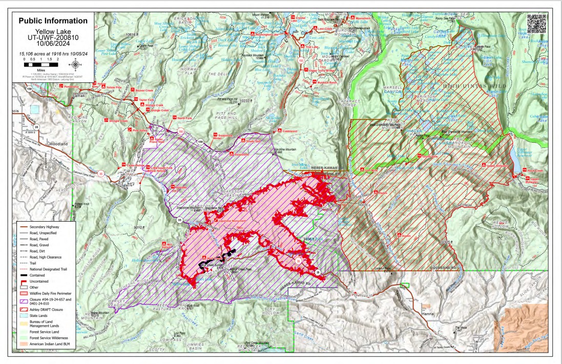
October 6, 2024 - The Yellow Lake Fire burned aggressively again yesterday. Supported by wind gusts of up to 40 miles per hour, relative humidity in the 20s; the fire has more than tripled in acreage. It is now mapped at 15,106 acres, with 7% containment. There are 471 personnel assigned to the fire.
Evacuation orders were issued for the North and West Forks of the Duchesne River. This is a mandatory evacuation, and all residents, hunters and recreationists must evacuate and stay out of the area. The Granddaddy Lakes area on the Ashley National Forest was issued a READY order, as well as Hanna, which prompts residents to have bags packed and be ready to leave if an evacuation order is given.
Yesterday, crews engaged where the fire behavior allowed, completing structure protection and hardening other infrastructure.
As the fire progressed, crews paralleled the fire’s front and conducted firing operations to consume fuel between the indirect line and the fire. This tactic can lower fire intensity and bring the fire perimeter to a place where resources can engage more easily.
The fire did spot into Heart Lake and get established but has mostly stayed on the ridge. Crews are holding the Mill Hollow Road, doing firing operations when possible to reduce fuel. The eastern and southern perimeter continue to see large fire growth, and it is expected to continue. The northern flank is mostly still burning parallel to Highway 150.
Additionally, aircraft flew buckets of water to extinguish hot spots, as well as drop retardant to slow the fire’s progression. But aircraft were limited due to the windy conditions and low visibility.
Today, crews will continue to assess structures, conduct firing operations when weather is favorable, and work toward increasing containment at the heel and flanks of the fire. There is no Red Flag warning today, but temperatures remain above average, with relative humidity below average. The fire’s footprint is such that growth is expected, but with moderated conditions, fire crews will have a better chance of securing portions of the perimeter.
Evacuations yesterday, were orderly, and we thank those that left immediately when asked. As a reminder, if you are asked to leave, please do. It has been determined that these areas present an immediate danger. Staying puts yourself and first-responders who may have to assist you in leaving later, in danger.
Rail Ridge Update 106202410 06 2024
Related Incident:
Publication Type: News
Central Oregon Wildfire Information: centraloregonfire.org
Email: 2024.railridge@firenet.gov – Phone: 541-208-7111
Social Media, Evacuation and Closure Information: https://linktr.ee/RailRidgeFire
Acres: 168,002 – Containment: 89% – Detection: 09/02/24 – Cause: Lightning – Personnel: 593
Forest closures are still in place and hazardous conditions remain within the fire area. Hazards include:
- Narrow, damaged, one-way roads
- Changing and unexpected fire behavior
- Hazard trees
- Unstable ground that has recently been burned
- Heavy equipment, vehicles, and crews on the roads
It is critical for the safety of forest visitors and fire personnel that no unauthorized people enter the fire area. Information including updates on the Rail Ridge Fire, the forest closure order, and a map with ODFW hunting management areas overlayed with the closure area and fire footprint can be found at https://linktr.ee/RailRidgeFire.
Operational Update
Yesterday, smoke was visible in the area as fuels continue to burn on the interior of the fire. Crews performed tactical firing operations to strengthen the dozer and hand lines around the active fire in the Black Canyon Wilderness. Firefighters worked diligently on protecting the communications site and lookout tower on Wolf Mountain. Yesterday’s firing operations helped secure that site. Suppression Repair work and mop-up continued around the fire.
Today, firefighters will be focusing on suppression repair and maintaining the perimeter along the edge of much of the fire. A slight afternoon increase in winds may cause some increased fire activity in the Black Canyon Wilderness area. Crews will continue to strengthen the perimeter and perform tactical firing operations as needed. Weather will continue to be seasonably warm, although the shorter days and higher relative humidity that come with early October will be shortening the afternoon burn period. Suppression repair remains a focus for the incident management team, and fire crews based out of both the Rager and Dayville fire camps will continue this important work. Patrolling of the uncontained areas around the northern edge of the fire and mop-up of any heat found along the contained fire edge will continue. Air resources remain available to firefighters as needed.
Weather: Above seasonally normal temperatures in the low to mid 70s are expected with dry conditions due to lower relative humidity than the last few days. Afternoon winds are expected with possible gusts up to 20mph.
Evacuations: Level 1 evacuations in Grant County were dropped this week and the level 2 evacuations remain. Wheeler County evacuation remain the same.
For Current Evacuation Levels all affected counties, please visit: https://linktr.ee/RailRidgeFire
Closures: The U.S. Forest Service and Bureau of Land Management have implemented closures for the Rail Ridge Fire. For more details and closure maps, visit https://linktr.ee/RailRidgeFire
RailroadDaly Fires Daily Update 10 06 2024
Related Incident:
Publication Type: News
Railroad-Daly Fires
Bitterroot National Forest
Fire Information: 458-218-2328
2024.dalyrailroad@firenet.gov
https://linktr.ee/sharrottjohnsondalyrailroad
October 6, 2024
Type 3 Incident Command Team, Incident Commander Matt Young
Location: Railroad Creek/ Skalkaho Creek confluence, 26 miles southeast of Hamilton
Start Date: 7/25/2024
Cause: Undetermined
Daly Fire Acres: 8,188 Completion: 56%; Railroad Fire Acres: 1,279 Completion: 35%
Total Personnel: 120
Current Status
A reconnaissance flight conducted yesterday revealed moderate growth on the Railroad and Daly Fire but has moderated since the recent wind event. The most significant activity was observed north of Fuse Lake/Duncie Creek area on the Beaverhead-Deerlodge National Forest side and below Gird Point on the Bitterroot National Forest side along State Highway 38.
Firefighters are actively working to assess and protect structures along the HWY 38 corridor and Gem Mine area. Opportunities for indirect lines from Highway 38 East and North into Stoney Creek drainage are being scouted. Fire progression will continue to be monitored below Gird Point while implementing direct & indirect control lines to stop progression to the west.
Weather and Fire Behavior
Warm, dry, and breezy conditions are expected this afternoon. As high pressure builds, the humidity levels will drop, which can make conditions more likely for wildfire spread.
Due to current and forecasted weather conditions, fire activity and potential will remain elevated for at least the next two weeks. Burn periods in the West will be significantly longer than normal and will intensify during wind events. In the Great Lakes, fire potential is expected to rise as leaf fall increases and significant precipitation remains unlikely. Anomalously dry conditions in the West will lead to increased fire activity for October, even without wind. During wind events, fire behavior may resemble that of August, with large runs and burn periods potentially exceeding 24 hours. Despite these challenges, the Railroad-Daly fire is showing moderate progress, particularly when compared to other wildfires in the region encountering similar conditions.
EVACUATIONS, RESTRICTIONS, CLOSURES
All areas along State Highway 38 (Skalkaho Highway) starting at mile marker 26.5 near Skalkaho Pass, turning north at the junction with Rock Creek Road (County Road 102), and continuing to the junction of State Highway 348 and Rock Creek Road. From there, it proceeds northwesterly on Rock Creek Road to USFS Road 241 (Stony Creek Road), moving southwest to the junction of Little Stony Creek and Stony Creek. Following Little Stony Creek west to the ridge where Trail 313 (Bitterroot Rock Creek Divide Trail) begins and continuing south along Trail 313 to the intersection with State Highway 38.
Middle Fork Complex Daily Update Oct 6th 2024 10 06 2024
Related Incident:
Publication Type: News
Middle Fork Complex: 61,490 acres, 90% completion, 227 Personnel
Snag Fire: 33,435 acres, 90% completion, 71 Personnel
Goat Fire: 31,345 acres, 41% completion, 103 personnel
The weather event on Friday pushed the northeast end of the Goat Fire approximately four miles to the Yellow Jacket Trail area. Firefighters were able to get into the area yesterday and worked to protect structures and bridges northeast of there. They were also able to directly engage some of the hot spots and are working to establish a contingency line further north toward the Warm Lake area in case the fire moves again.
The northeast most end of the Goat Fire is now in the middle of an old burn scar and fire activity was greatly reduced. Crews will remain in the area watching for activity late into the night and for the next few nights. The southern end of the Goat Fire in the Silver Creek area was also fairly active during the weather event.
The Middle Fork Complex and the Snag Fire areas did not see a significant increase in fire behavior during the weather event. Fire activity in all three fire areas may continue to be active as the extended hot weather continues to dry out fuels.
The next four days are forecast to be unseasonably warm and dry. Temperatures are expected to be mid-60s to 70 and humidity in the upper teens. Southwest winds will mainly be at the ridgelines with some terrain driven gusting. No significant fire growth is expected at this time, but crews will remain vigilant and continue to work on suppression and containment efforts.
Suppression repair work on the west side of the Middle Fork Complex and Snag Fire is mostly complete and crews working there expect to be done this week.
Please check the Valley County Idaho Facebook page for any updates on evacuation readiness level changes. Residents are encouraged to sign up for Code Red Emergency Alerts to stay informed. For any questions or updates on evacuation readiness, please contact the Valley County Dispatch Center at 208-382-5160. Currently, Warm Lake Road remains open for travel without restrictions.
Forest area and road closures remain in effect. Visit the Middle Fork Complex Fire Facebook page for a detailed description of where those closures are.
###
HomesteadDiamond Complexes Daily Fire Update 10 06 2024
Related Incident: Lane 1 Fire
Publication Type: News
Homestead/Diamond Complexes Fire Update
Oct. 6, 2024
Fire Information: 541-208-7100, 8 AM - 8 PM
InciWeb-Homestead: https://t.ly/syeHa and InciWeb-Diamond: https://bit.ly/4gCfLsp
Six fires within the Homestead and Diamond Complexes remain under active management by Northwest Team 12. Firefighting resources from the Homestead/Diamond Complexes remain available for initial attack response to new fire starts in the area as needed.
The Oregon Department of Transportation temporarily lowered the speed limit on Hwy 138 in front of the Fire Incident Command Post just east of Glide to 45 MPH for the safety of firefighters and community residents.
Homestead Complex: 10,552 acres, 35% contained │ Diamond Complex: 11,141 acres, 90% contained │ Total personnel: 291
Another day of warm and dry conditions contributed to an increase in fire activity yesterday as well as minor fire growth on a portion of the Homestead Complex. Fire managers took a reconnaissance helicopter flight to evaluate fire activity across the fires that remain under active management.
There was little fire activity on the Horse Heaven Fire yesterday, helping firefighters to successfully hold the fire on the east side of Horse Heaven Creek. Crews are making progress in seeding and spreading straw over dozer lines, in an effort to prevent erosion. Grading continues along multiple Forest Service Roads (FSRs) and an excavator is cleaning out woody debris from ditches on FSR 3831.
The Fuller Lake Fire was active again with spotting, isolated tree torching, and backing fire within the Boulder Creek Wilderness. Firefighters detected multiple small spot fires yesterday and quickly secured them. Crews remain extra vigilant in their patrols, as heavy duff layers on the forest floor can harbor undetected smoldering fire, and changing weather conditions could lead to unexpected flare ups. On the Bullpup Fire, roads continue to be graded and cleaned up from chipping and previous mastication operations.
Smoke was visible again on the No Man Fire yesterday, but fire activity remained minimal. Firefighters proactively reopened fireline to the south to ensure the fire stays in check.
Two fires remain uncontained on the Diamond Complex. On the Potter Fire, excavators are clearing ditches along FSR 100 and grading operations are ongoing. The Pine Bench Fire continues to show no visible smoke.
Closures: The Umpqua National Forest revised the fire closure area on Friday. The updated Umpqua National Forest closure and map can be found at https://tinyurl.com/bmtfvvz6. The BLM Roseburg District closure order also remains in place https://t.ly/uWX6l. A Temporary Flight Restriction remains in effect https://bit.ly/3XJL0cD.
Weather: High pressure will remain in place over the Pacific Northwest through Monday. Expect conditions to be warmer and drier than normal for this time of the year, with temperatures forecasted to be 75-82 degrees in the valleys.
Elk Fire Update Sunday October 6 2024 10 06 2024
Related Incident: Elk Fire 2024
Publication Type: News
Elk Fire Update – October 6, 2024
Rocky Mountain Area Complex Incident Management Team 3
Casey Cheesbrough, Incident Commander
Date Reported: Friday, September 27, 2024
Cause: Undetermined
Size: 72,998
Containment: 0%
Total Personnel: 597
Location: Approximately 6 miles northwest of Dayton, Wyoming
Key Messages: Smoke is settling over the Elk Fire area from fires further to the west. This is expected to continue and is likely to decrease fire activity today. This smoke may also impact air operations as helicopters need a minimum of one mile visibility to operate on wildland fires.
Last night’s operational shift found heat coming from a structure on the eastern side of the fire; heavy equipment was used to remove burning hay inside a barn. The fire was extinguished outside of the structure.
An overnight flight was able to provide more precise mapping capabilities, resulting in a new fire size of 72,998 acres.
Current Situation:
Structure protection work will continue on the northwestern side of the fire in Little Horn Canyon and crews will be looking for favorable conditions to burn unconsumed vegetation south of Hwy 144. On the eastern side of the fire, crews will continue to extinguish areas of heat along established firelines; that area has been holding with no further fire progression past the firelines.
Crews will continue structure protection work in the subdivisions along US HWY 14 and patrol and mop up any heat sources around structures. Structure protection tactics have been utilized to prepare the Big Goose Water Treatment facility for any fire that may move into the area. Efforts are continuing to mitigate fire damage to the Big Goose Creek watershed, which feeds the water treatment facility.
Fire crews continue structure protection work in the Burgess Junction area; this work includes multiple structure preparation techniques such as removal of vegetation near structures, construction of fireline, and placement of hose and sprinklers where possible.
Firefighter and public safety remain the top priority. The tactics used to suppress the fire will be determined by the terrain, fire and weather conditions, and medical response time with a focus on implementing plans and tactics that have a high probability of success.
Closures and Evacuations: The newest evacuation map can be found at the Sheridan County Emergency Management website, Sheridan County (sheridancountywy.gov). US Highway 14 remains closed from Dayton to Burgess Junction. Please contact the Sheridan County Sheriff’s Office at 307-672-3455 or Sheridan County Emergency Management at 307-752-2174 for more information on evacuations and road closures.
The Bighorn National Forest Closure has been expanded to include the closure of Red Grade Road. Please view the updated order on the Bighorn National Forest website, Bighorn National Forest - Alerts & Closures (usda.gov).
Weather & Smoke Information: Today is the start of a warming, drying trend over the fire area as a high pressure system moves into the area. Winds are expected to be light and terrain-driven over the course of the day. Smoke that is anticipated to move into the area from fires further to the west may cause smoke shading and keep temperatures lower than the forecasted highs ranging in the mid 60s to low 70s.
It is anticipated that the Elk Fire will continue to put up a smoke column; please go to the AirNow website (https://www.airnow.gov/) for smoke information.
Morning Update Frog Fire Sunday 10 06 2024
Related Incident: Frog
Publication Type: News
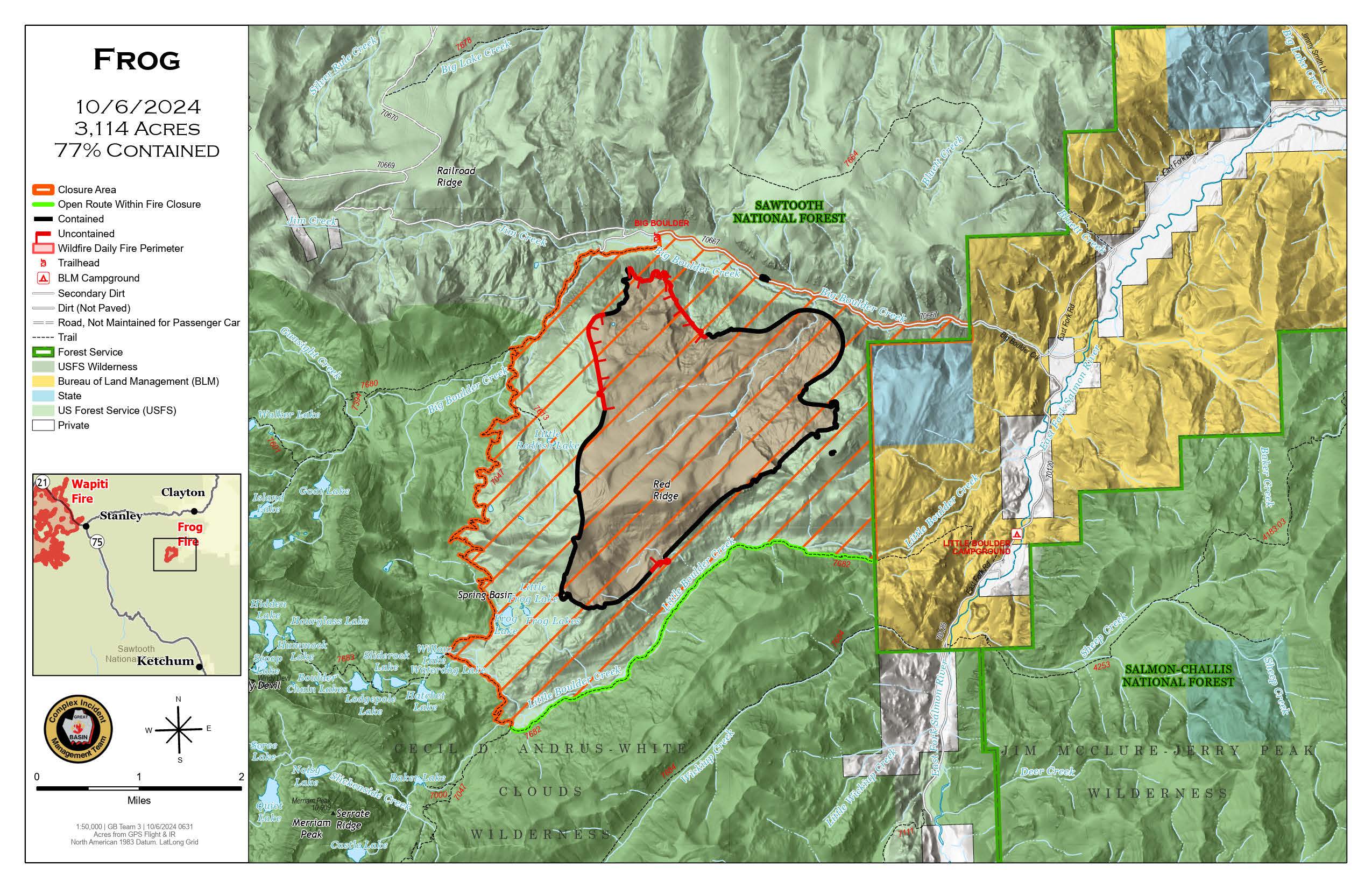
Frog Fire Statistics
- Size: 3,114 acres
- Containment: 77%
- Total Personnel: 35
- Location: east of Clayton, ID
- Reported: September 7, 2024
- Cause: Lightning
For More Information
InciWeb: https://inciweb.wildfire.gov/incident-information/idstf-frog
Facebook: https://www.facebook.com/sawtoothnationalforest
Current Situation: An infrared flight was flown over the Frog Fire last night. Crews will be verifying the containment lines and searching for the heat signature found in the Red Ridge area. Crews planned to recheck fire line on the north end of the fire.
Evacuations: There are currently no evacuations related to the Frog Fire.
Closures: The area closure in place around the Frog Fire includes FS 667 (Big Boulder Creek Road) and Trail 047 where adjacent to the closure boundary. The closure excludes FS Roads 669 and 670 and Trail 682. Hunters and recreationalists should familiarize themselves with this closure information prior to entering the vicinity. Please reference the map and read the full closure description at https://inciweb.wildfire.gov/incident-closures/idstf-frog.
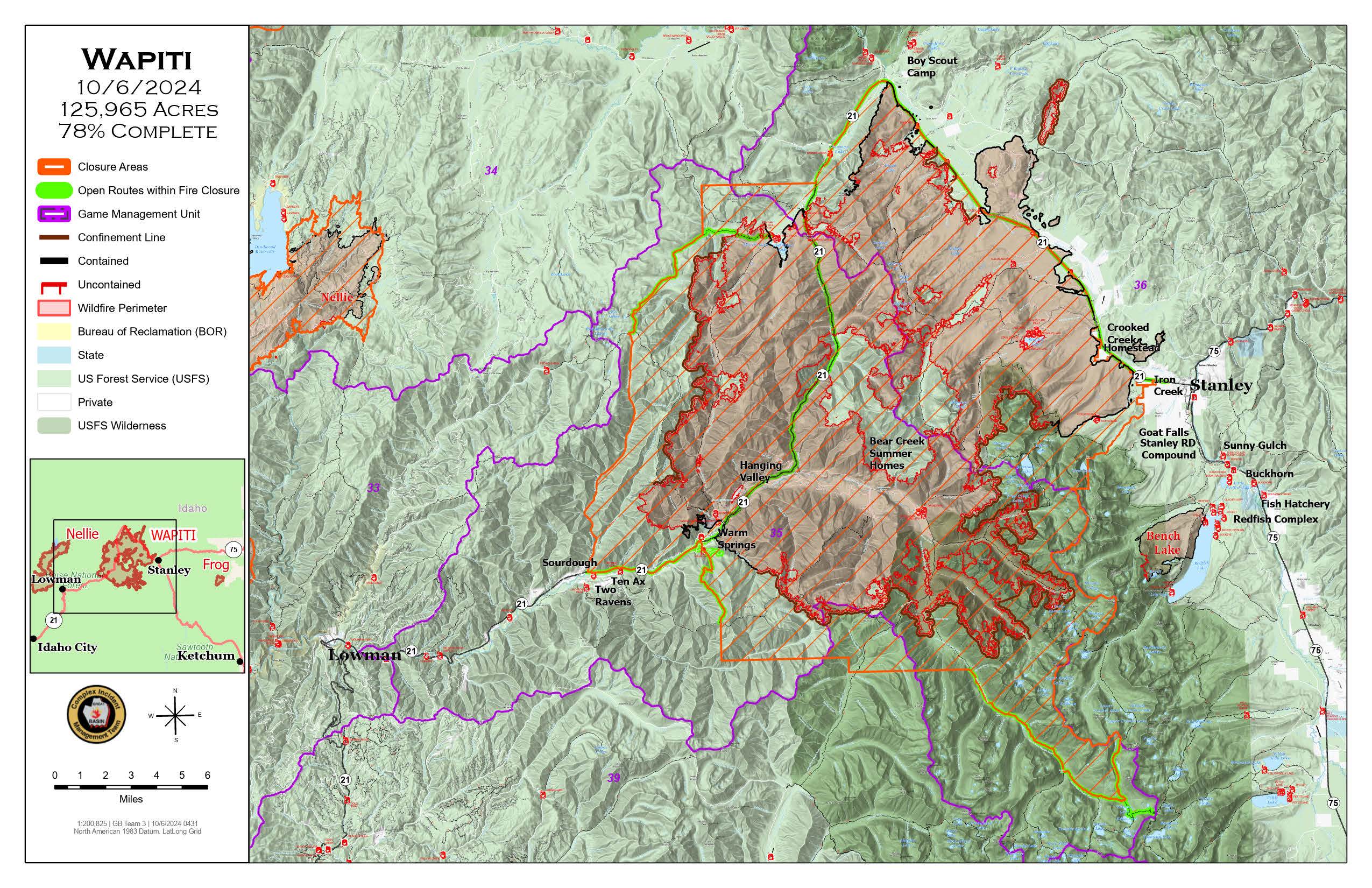
Wapiti and Frog Fires Daily Update 10 06 2024
Related Incident:
Publication Type: News
Special Emphasis: Yesterday evening, Great Basin Complex Incident Management Team (CIMT) #3 took command of the Wapiti and Frog Fires.
The Air Quality Index (AQI) in the Stanley Basin is rated green today which indicates good air quality. You can check air quality and the AirNow Fire and Smoke Map at https://www.airnow.gov/.
With the changing of the closure areas, please ensure you check the boundaries prior to recreating or traveling. Many trails remain closed for public safety because they have not been cleared of potential hazards. The collection of firewood within the closure areas is prohibited; any firewood collection in open areas must be done with a valid firewood permit. For questions on firewood collection on the Sawtooth National Forest, please contact the Stanley Ranger Station at 208.774.3000.
Weather: Saturday’s winds were much calmer in the afternoon, with gust around 10 -15 compared to Friday’s gusts of 20 to 40 mph over the Wapiti Fire. Frog Fire also had calmer winds. Today temperatures will be in the high 60’s and 70’s with higher humidity.
Wapiti Fire Statistics
For More Information
Size: 125,965 acres
Completion: 80%
Total Personnel: 194
Location: near Grandjean, ID
Reported: July 24, 2024
Cause: Lightning
InciWeb: https://inciweb.wildfire.gov/incident-information/idbof-wapiti-fire
Facebook: https://www.facebook.com/wapitifireinfo2024
Linktree: https://linktr.ee/WapitiFireInfo2024
Current Situation: Yesterday, fire crews and engines were spread throughout the fire area to monitor and patrol fire activity and implement suppression actions if needed to protect values. Saturday afternoon minimal fire behavior was observed as the fire was creeping and backing down areas well within the interior and some smoldering of heavy fuels on the ground.
Today crews will be working in several areas. The Iron Creek area is available to firewood collecting for those with a permit and exemption to be in that area. A group will be placed in the Grandjean area including an engine to remove hazardous trees and debris. They will also be working on a project to restore access to the Grandjean water system. Firefighters will also be removing snags and debris along the Hwy 21 corridor. Please be cautious while traveling along Hwy 21.
Evacuations: Evacuation status for Stanley Zone 1 is currently at READY. All residents should remain alert for any change in conditions that may reinitiate an evacuation status. Sign up for Custer County CodeRED emergency notifications: text CUSTER to 99411 or enroll at https://public.coderedweb.com/CNE/BF28E45537FF. Sign up for Boise County Alert Sense emergency notifications at https://public.alertsense.com/SignUp/publicUser.aspx?regionid=1163.
For evacuation information on the Wapiti Fire, please see the Custer County Sheriff’s Facebook page, https://www.facebook.com/p/Custer-County-Sheriff-Idaho-61558947312289/, and the Boise County Sheriff’s Facebook page, https://www.facebook.com/boisecountysheriff/.
Closures: The Wapiti Fire area closure has been reduced on the southern end, excluding the Lowman, Ten Ax, Two Raven, and Sourdough communities. The closure still covers portions of the Sawtooth, Boise, and Salmon-Challis National Forests. Please reference the map and description at https://inciweb.wildfire.gov/incident-closures/idbof-wapiti-fire. Recreationalists and hunters should reference this map and obey all posted signage regarding the closure area and any related road, trail, and campground closures.
An interactive map for all closures on the Boise National Forest is found at https://experience.arcgis.com/experience/642380b0eb124c8cab6bd9ad3d7146ad/page/Overview/#data_s=id%3AdataSource_5-1888bd00a2c-layer-13-1888bd00b53-layer-16%3A82.
Frog Fire Statistics
For More Information
Size: 3,114 acres
Containment: 77%
Total Personnel: 35
Location: east of Clayton, ID
Reported: September 7, 2024
Cause: Lightning
InciWeb: https://inciweb.wildfire.gov/incident-information/idstf-frog
Facebook: https://www.facebook.com/sawtoothnationalforest
Current Situation: An infrared flight was flown over the Frog Fire last night. Crews will be verifying the containment lines and searching for the heat signature found in the Red Ridge area. Crews planned to recheck fire line on the north end of the fire.
Evacuations: There are currently no evacuations related to the Frog Fire.
Closures: The area closure in place around the Frog Fire includes FS 667 (Big Boulder Creek Road) and Trail 047 where adjacent to the closure boundary. The closure excludes FS Roads 669 and 670 and Trail 682. Hunters and recreationalists should familiarize themselves with this closure information prior to entering the vicinity. Please reference the map and read the full closure description at https://inciweb.wildfire.gov/incident-closures/idstf-frog.