
Middle Fork Complex Daily Update Oct 5th 2024 10 05 2024
Related Incident:
Publication Type: News
Middle Fork Complex Fire Update
October 5, 2024
Middle Fork Fire Information: 208-992-3045 (8 a.m. – 8 p.m.) | Email: 2024.middleforkcomplex@firenet.gov
Middle Fork Complex: 61,490 acres, 90% completion, 199 Personnel
Snag Fire: 33,435 acres, 90% completion, 63 Personnel
Goat Fire: 28,557 acres, 41% completion, 111 personnel
Firefighters worked late into the night managing the Goat Fire, which made a significant advance in the northeast corner of Valley County, south of Stolle Valley due to strong, gusty winds during the day. The edge of the fire moved over a mile to the northeast and is now near the Yellow Jacket Creek Trail Bridge.
Firefighters in the area are continuing to focus on protecting bridges and other important structures from the fire which is being fueled by dry grass, brush, and downed trees in an area that burned in 2007. Conditions are expected to improve as the dry cold front moves into the area bringing a wind shift that could help push the fire back on itself. They are also working on contingency and control lines to keep the fire from further impacting the residents in the Warm Lake area.
Fire activity in the rest of the Snag and Middle Fork Complex areas is still mostly smoldering and creeping, and suppression repair work continues in these areas.
The Valley County Sheriff’s Office has issued a "Ready Evacuation” notice for the Warm Lake area due to the Goat Fire's movement. The fire has worked its way around the Silver Creek Lookout, but so far, there are no reports of damage to any structures there.
Valley County residents are encouraged to sign up for Code Red Emergency Alerts to stay informed. For any questions or updates on evacuation readiness, please contact the Valley County dispatch center at 208-382-5160. Currently, the Warm Lake Road remains open for travel without restrictions.
Boise National Forest closures remain in effect and the road closure on the Middle Fork Road remains in place. Visit the Middle Fork Complex Fire Facebook page for a detailed description of where that road closure is. Additional closure information is available at this link: https://www.fs.usda.gov/alerts/boise/alerts-notices.
Air support was limited yesterday due to a new fire near Boise that immediately threatened homes, along with a smaller fire in Valley County called the Bummer Fire.
###
Yellow Lake Fire Update 10 05 2024
Related Incident: Yellow Lake Fire
Publication Type: News
Note: Infrared Flight occurred late, and maps are delayed. They will be added later
October 5, 2024— Yesterday was a particularly challenging day, with red flag conditions that are prime for fire growth—high winds, record-breaking temperatures, extremely low humidity, and unseasonably dry weather. Despite these tough conditions, firefighters worked diligently to reduce the fire’s impact where possible, but the primary focus remained on ensuring the safety of fire personnel and the public. Everyone safely exited the field by the end of the day, which will always be the top priority.
During the predicted wind event, multiple wind-driven spot fires ignited north of Highway 35 and the pipeline, establishing in timber and producing more visible smoke. The fire took advantage of available fuels and favorable winds, causing it to spot and burn in pulses. This led to its spread toward Soapstone Pass and east toward Rhodes Canyon. The fire is now burning south and parallel to Highway 150 (Mirror Lake Highway), though it is not currently impacting that area. The estimated acreage is now 7,798, though this will continue to adjust with updated infrared mapping.
Today’s forecast brings another day of strong winds and shifting directions. Crews will continue their full suppression efforts, focusing on minimizing fire movement into the West Fork of the Duchesne drainage, north into Soapstone Basin, west toward Mill Hollow ,and East towards the North Fork of the Duchesne. They are also working to protect structures and other values. While the fire may continue to grow, crews will prioritize holding the anchor point and keeping the fire in a manageable area where suppression efforts can be most effective.
As of last night, the YMCA camp and ranger station remain safe, with structure protection measures in place, including sprinklers and hose-lays for added defense. Piuta Girls Camps and recreation structures within the closure area were treated with retardant.
A forest closure is now in effect for both the portions of the Uinta-Wasatch-Cache and Ashley National Forests affected by the fire. Yesterday demonstrated how quickly the fire can spot over long distances and spread rapidly in the heavy timber, aided by strong winds and dry conditions. With another red flag warning in effect, forest managers are taking a conservative approach to ensure public and firefighter safety amid the unpredictable weather and unseasonably dangerous conditions.
The fire has been determined to be human-caused and remains under investigation. Further information will be provided once the final investigation report is completed.
The Yellow Lake Fire is burning east of Mill Hollow Reservoir on the Uinta-Wasatch-Cache National Forest, with 423 personnel currently assigned to the incident.
Rail Ridge Update 10 05 2024
Related Incident:
Publication Type: News
Central Oregon Wildfire Information: centraloregonfire.org
Email: 2024.railridge@firenet.gov – Phone: 541-208-7111
Social Media, Evacuation and Closure Information: https://linktr.ee/RailRidgeFire
Acres: 168,002 – Containment: 89% – Detection: 09/02/24 – Cause: Lightning – Personnel: 601
Forest closures around the Rail Ridge and Crazy Creek Fires remain in place. A map with the ODFW hunting management unit areas overlaid with the closure area and fire footprint can be found at: https://linktr.ee/RailRidgeFire. For the safety of firefighters and forest visitors it is of the utmost importance that the closure areas remain in place at this time. Potential hazardous circumstances associated with the area include hazard trees and ground stability in recently burned areas, continued burning within the interior of the fire, firefighters and apparatus traveling and working in the area and there is no means to quickly notify public in the fire area of emerging safety concerns.
Operational Update
Yesterday, the passing cold front brought high winds across the fire area which tested the established containment lines. No significant growth was reported, and current containment lines held. Interior pockets of fuels did become active during the afternoon, and the westerly side of the fire in the Black Canyon Wilderness continued burning through the Honeymoon Creek area. Tactical firing operations were completed to prevent fire from advancing toward Wolf Mountain Lookout and the communication site. Early in the day a smoke column west of the Rail Ridge Fire was reported. Local resources responded and found and unburned island of fuel within the Crazy Creek Fire footprint to be burning and was suppressed quickly.
Last night’s relative humidity recovery is a welcome start to the weekend for firefighters. Coupled with predicted lighter winds, fire activity is expected to be minimal. Interior flare-ups and additional acres of burning in the Black Canyon Wilderness area will continue to produce smoke. Firefighters will continue to strengthen contingency control lines and containment around the Black Canyon Wilderness. As needed, tactical firing operations will be used to add depth to lines that are already in place. Suppression repairs are ongoing with resource advisors, and mop-up and patrolling will continue around the contained portions of the fire.
Weather
Terrain driven winds around 10mph are expected over the fire area with mostly sunny conditions and temperatures in the mid to upper 60’s. Relative humidity will again recover tonight to an estimated 75-80% but will dip into the 20-25% range in the afternoon today.
Evacuations
Level 1 evacuations in Grant County were dropped this week and the level 2 evacuations remain. Wheeler County evacuation remain the same.
For Current Evacuation Levels all affected counties, please visit: https://linktr.ee/RailRidgeFire
Closures
The U.S. Forest Service and Bureau of Land Management have implemented closures for the Rail Ridge Fire. For more details and closure maps, visit https://linktr.ee/RailRidgeFire
HomesteadDiamond Complexes Daily Fire Update 10 05 2024
Related Incident: Lane 1 Fire
Publication Type: News
Homestead/Diamond Complexes Fire Update
Oct. 5, 2024
Fire Information: 541-208-7100, 8 AM - 8 PM
InciWeb-Homestead: https://t.ly/syeHa and InciWeb-Diamond: https://bit.ly/4gCfLsp
Six fires within the Homestead and Diamond Complexes remain under active management by Northwest Team 12. Firefighting resources from the Homestead/Diamond Complexes remain available for initial attack response to new fire starts in the area as needed.
The Oregon Department of Transportation temporarily lowered the speed limit on Hwy 138 in front of the Fire Incident Command Post just east of Glide to 45 MPH for the safety of firefighters and community residents.
Homestead Complex: 10,500 acres, 35% contained │ Diamond Complex: 11,141 acres, 90% contained │ Total personnel: 353
Anticipated precipitation failed to materialize across the fire area yesterday, although cooler temperatures and moisture helped to subdue fire behavior through mid-day. In the afternoon, fire activity picked up again on multiple fires, prompting firefighters and aircraft to engage.
On the Horse Heaven Fire, previously active fire areas were relatively quiet yesterday. Firefighters are successfully keeping the fire on the east side of Horse Heaven Creek. Grading continues along Forest Service Roads (FSRs) 3831 and 2213 and heavy equipment continues to break down dozer berms along FSR 5850. Crews are completing hand line repair and will begin seeding and spreading straw over repaired fire control lines to help prevent erosion.
The Fuller Lake Fire was active again with isolated tree torching and backing fire within the Boulder Creek Wilderness. Firefighters on patrol located and secured a spot fire across FSR 3810 on the east side of the fire. Today, crews will continue to patrol and secure any spot fires that emerge. Sawyers continue to assess and mitigate fire-weakened trees along roads. Road work is ongoing on the Bullpup Fire along FSR 200 and chipping continues along FSRs 3816 and 300.
Engine crews patrolling the No Man Fire yesterday discovered a flare up along the south side of the fire. A heavy helicopter dropped approximately 22,000 gallons of water to cool the flames. Helicopters will remain available today to assist if activity picks up again. Firefighters will also be working on opening up firelines on the south end to keep the fire contained.
Two fires remain uncontained on the Diamond Complex. On the Potter Fire, road graders continue to make progress at the pace of approximately two-three miles per day working along FSR 3703. The Pine Bench Fire continues to show no visible smoke.
Closures: The Umpqua National Forest revised the fire closure area yesterday. The updated Umpqua National Forest closure and map can be found at https://tinyurl.com/bmtfvvz6. The BLM Roseburg District closure order also remains in place https://t.ly/uWX6l. A Temporary Flight Restriction remains in effect https://bit.ly/3XJL0cD.
Weather: There will be a warming and drying trend through Tuesday as a ridge of high pressure builds over the region. Temperatures will be above normal, with 73-78 degrees forecasted in the valleys today.
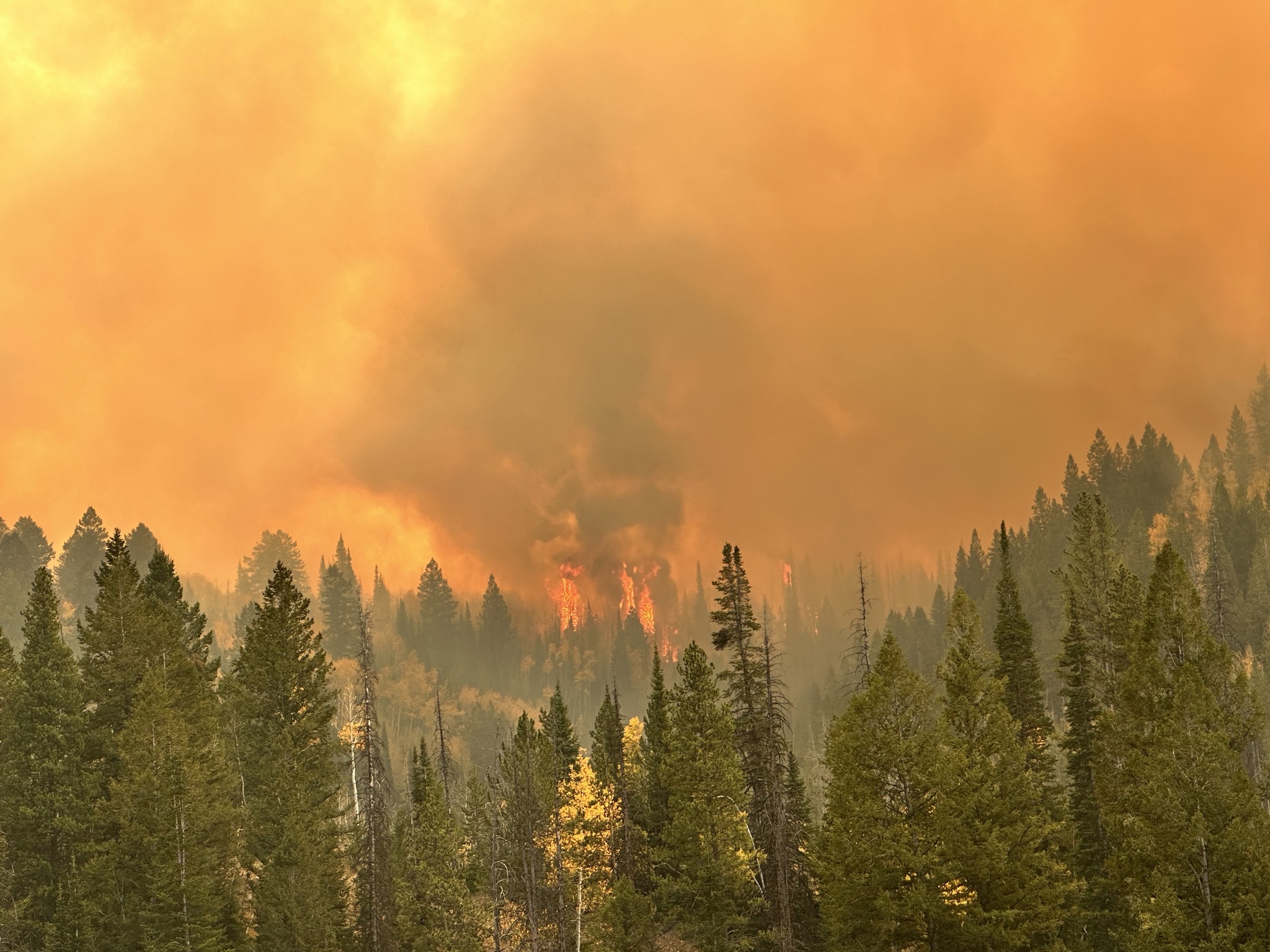
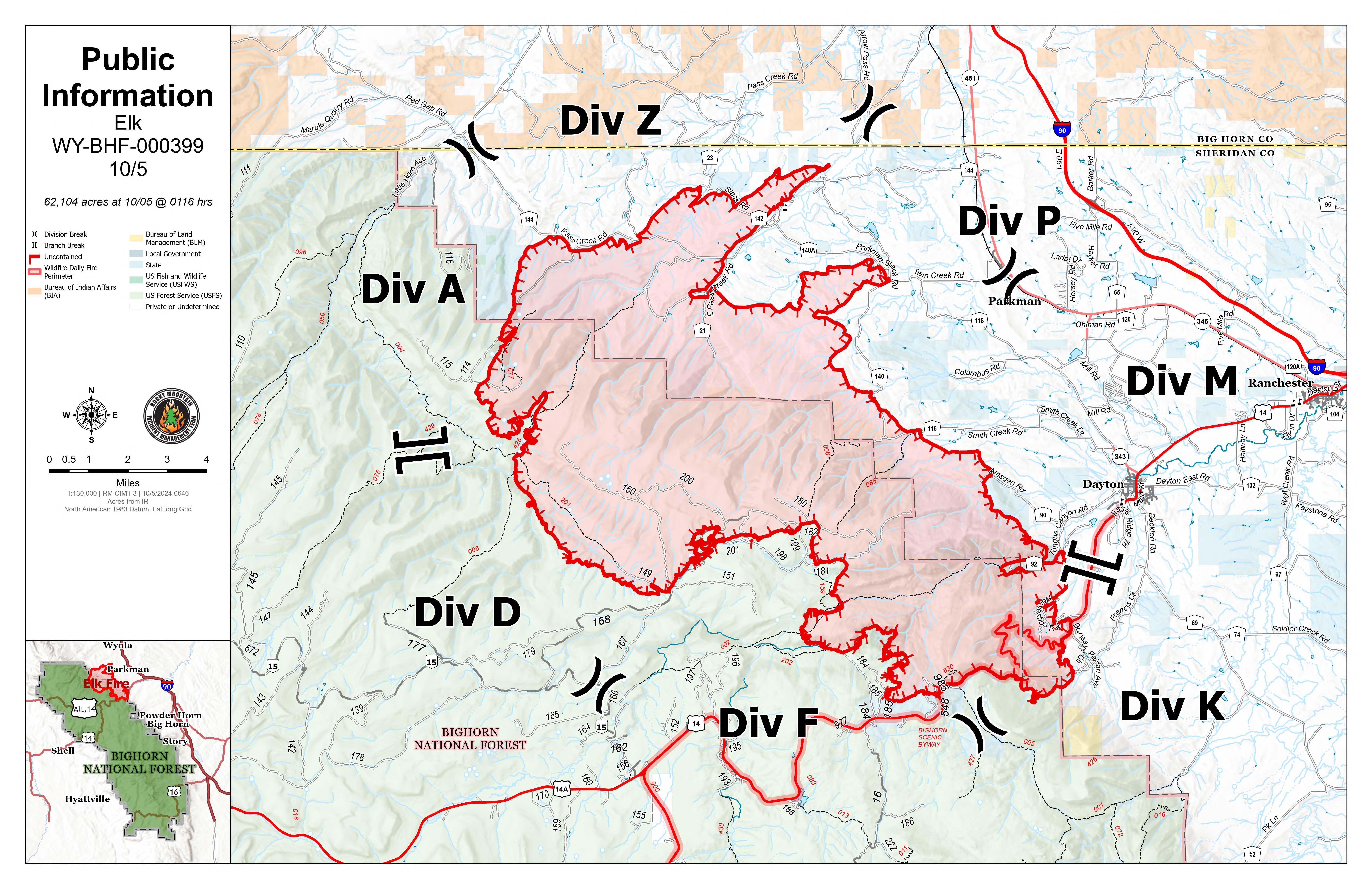
Elk Fire Daily Update Saturday October 5 2024 10 05 2024
Related Incident: Elk Fire 2024
Publication Type: News
Elk Fire Update - October 5, 2024
Rocky Mountain Area Complex Incident Management Team 3
Casey Cheesbrough, Incident Commander
Date Reported: Friday, September 27, 2024
Cause: Undetermined
Size: 62,104
Containment: 0%
Total Personnel: 584
Location: Approximately 6 miles northwest of Dayton, Wyoming
Key Messages: Due to fire activity, the Sheridan County Sheriff increased the evacuation levels in the following areas:
- “GO” -West of Beckton Road from Dayton, continuing south to the intersection of Beckton Road to Eaton Ranch Road. Eagle Ridge Subdivision and the homes directly east of US Hwy 14, heading up the mountain
- “SET” - Town of Dayton
Fire crews were very busy overnight around the fire perimeter. The highest fire activity was experienced on the southeastern side of the fire. Crews were forced to evacuate from subdivisions along US HWY 14 due to extreme fire behavior associated with the cold front passage at approximately 1:30 a.m.
On the northwest area of the fire crews conducted a quick burning operation along Cty Rd 144, in the vicinity of Gay Creek to stop the spread of the fire. This firefighting was done by hotshot crews, engines, heavy equipment, and water tenders.
As fire behavior moderated in the early morning hours, crews returned to the area to resume structure protection work.
Current Situation:
Fire behavior is expected to remain high today as winds will likely push fire to the southeast and downslope movement is likely to be seen on the face of the mountain.
Along the eastern side of the fire, crews will continue to extinguish areas of heat along established firelines; that area did not see movement overnight. Crews will continue structure protection work in the subdivisions along US HWY 14 now that the fire front has passed by.
Structure protection work is ongoing in the Burgess Junction area; this work includes multiple structure preparation techniques such as the removal of vegetation near structures, construction of fireline, and placement of hose and sprinklers where possible.
Firefighter and public safety remain the top priority. The tactics used to suppress the fire will be determined by the terrain, fire and weather conditions, and medical response time with a focus on only implementing plans and tactics that have a high probability of success.
Closures and Evacuations: The newest evacuation map can be found at the Sheridan County Emergency Management website, Sheridan County (sheridancountywy.gov). US Highway 14 remains closed from Dayton to Burgess Junction. Please contact the Sheridan County Sheriff’s Office at 307-672-3455 or Sheridan County Emergency Management at 307-752-2174 for more information on evacuations and road closures.
The Bighorn National Forest Closure has been expanded to include the closure of Red Grade Road. Please view the updated order on the Bighorn National Forest website, Bighorn National Forest - Alerts & Closures (usda.gov).
Weather & Smoke Information: A Red Flag Warning runs through 6:00 p.m. this evening. This critical fire weather is primarily due to continued high winds. The winds are forecast to continue out of the northwest with speeds 15-25mph and gusts to 35mph this morning and into early afternoon. Wind speeds are expected to decrease around 1800.
It is anticipated that the Elk Fire will continue to put up a smoke column; please go to the AirNow website (https://www.airnow.gov/) for smoke information.
###
Goosmus Fire FINAL Update 1052024 10 05 2024
Related Incident: Goosmus Fire
Publication Type: News
Yesterday, crews were able to isolate the remaining hotspots along the fireline, extinguishing them within 100’ to 400’ of the line. Containment has been complete on the fire and crews disassembled hose lays, pumps and other firefighting apparatus to return to cache. Crews will focus on rehabilitation and patrol, before demobilizing and returning to home districts or reassignment to other fires in the area. A smaller team (type 4 organization) will continue on the incident into next week, focusing on continued patrol of the fireline, as well as complete any additional needed rehabilitation.
Fuels will continue to burn and smoke will be observable for at least several weeks within the perimeter of the fire and are unlikely to spread beyond the containment line.
Our Incident Management Team would like to thank everyone in the surrounding communities for their support of the firefighters and our team, it was instrumental in our success!
Settings - change map background and toggle additional layers
Filter - control incident types displayed on map.
Zoom to your location
Reset map zoom and position
Could not determine your location.
Show Legend
 Wildfire
 Prescribed Fire
 Burned Area
Response
Burned Area
Response Other
Other
Tiger Creek Fire
Unit Information
Incident Contacts
GARDEN FIRE CLOSURE 10 05 2024
Related Incident:
Publication Type: Closures
The Salmon‐Challis National Forest has implemented the Garden Fire Closure, Order Number: 04‐13‐24‐023.
Description of #04-13-24-023:
DESCRIBED AREA, ROADS AND TRAILS:
Fire Area Closure:
NFS lands, roads, and trials on the Slamon-Cobalt Ranger District of the Salmon-Challis National Forest within the area bounded by the following: Beginning at Ebeneezer Bar on the Salmon River Rd. East 7.5 miles to a North South Ridge that is 1 Mile East of Panther Rd. South on the North South Ridge approximately 14 miles until it meets with the Panther Rd. near Trapper Flat. From Panther Rd. and Trapper Flat West along Big Deer Creek 7.5 Miles to the intersection of Big Deer Creek and 029 Trail. From Big Deer Creek and 029 Trail North 13 Miles to the intersection with Ebeneezer Bar.
Cadigan Area Closure:
Road 60070 and approximately 130 acres associated with the 60070 Rd.
The purpose of this order is to protect public health and safety from the effects of the Garden Fire.
This Order shall be in effect from October 4, 2024, at 4:00 pm until October 31, 2024, at 8:00 am or until rescinded.
Visit our website at: www.fs.usda.gov/scnf/, ‘Like Us’ on Facebook @salmonchallisnf, and ‘Follow Us’ on X @salmonchallisnf.
####
USDA is an equal opportunity provider, employer, and lender.
Morning Update Frog Fire Saturday 10 05 2024
Related Incident: Frog
Publication Type: News
Frog Fire Statistics
- Size: 3,114 acres
- Containment: 77%
- Total Personnel: 24
- Location: east of Clayton, ID
- Reported: September 7, 2024
- Cause: Lightning
For More Information
InciWeb: https://inciweb.wildfire.gov/incident-information/idstf-frog
Facebook: https://www.facebook.com/sawtoothnationalforest
Current Situation: Helicopters were able to briefly drop water from buckets on hot areas of the Frog Fire yesterday, until wind gusts grew too strong. The firefighters still assigned to the fire watched from a safe vantage point and saw no significant increase in fire activity. Today they will work along the northern edge of the fire, where the fire is still uncontained. With more favorable weather conditions, they expect to have more helicopter support as they work.
Evacuations: There are currently no evacuations related to the Frog Fire.
Closures: The area closure in place around the Frog Fire includes FS 667 (Big Boulder Creek Road) and Trail 047 where adjacent to the closure boundary. The closure excludes FS Roads 669 and 670 and Trail 682. Hunters and recreationalists should familiarize themselves with this closure information prior to entering the vicinity. Please reference the map and read the full closure description at https://inciweb.wildfire.gov/incident-closures/idstf-frog.
Daily Update Wapiti Fire Saturday 10 05 2024
Related Incident:
Publication Type: News
Wapiti Fire Statistics
- Size: 125,965 acres
- Completion: 78%
- Total Personnel: 242
- Location: near Grandjean, ID
- Reported: July 24, 2024
- Cause: Lightning
For More Information
InciWeb: https://inciweb.wildfire.gov/incident-information/idbof-wapiti-fire
Facebook: https://www.facebook.com/wapitifireinfo2024
Linktree: https://linktr.ee/WapitiFireInfo2024
Interactive Map: https://tinyurl.com/WapitiFireInfoMap
Special Emphasis: This evening, Great Basin Complex Incident Management Team (CIMT) #4 will transition command of the Wapiti and Frog Fires to Great Basin CIMT #3, who will be the sixth CIMT assigned to the Wapiti Fire. On behalf of Team #4, thank you to the communities, partners, stakeholders, and landowners who worked with us and supported us throughout our assignment.
The Air Quality Index (AQI) in the Stanley Basin is rated yellow/moderate today which indicates acceptable air quality but very sensitive people could be impacted and may want to limit outdoor exposure. You can check air quality and the AirNow Fire and Smoke Map at https://www.airnow.gov/.
With the changing of the closure areas, please ensure you check the boundaries prior to recreating or traveling. Many trails remain closed for public safety because they have not been cleared of potential hazards. The collection of firewood within the closure areas is prohibited; any firewood collection in open areas must be done with a valid firewood permit. For questions on firewood collection on the Sawtooth National Forest, please contact the Stanley Ranger Station at 208.774.3000.
Weather: Yesterday’s winds were slightly muted compared to forecasts by the smoke that drifted over the Stanley Basin from other Idaho fires. Gusts between 20 and 40 mph were recorded over the Wapiti Fire area. Gusts of 50 to 60 mph were recorded over the Frog Fire area. Activity on both fires was minimal despite the winds. Today will be cooler and relative humidity will rise.
Current Situation: Fire crews and engines were spread throughout the fire area yesterday to monitor fire activity and respond as necessary. Smoke from other fires in the state acted like cloud cover to shade out the Wapiti Fire, and the fire was not as active as predicted. Winds were still strong enough to limit aviation flights. Early in the day, one helicopter was sent to assist with the Valley Fire burning just east of Boise, ID; it is expected to return today. Today, firefighters will continue suppression repair work near Stanley Lake. They are nearly complete with repair, having completed 27.9 miles of dozer line and 21.3 miles of handline. The fire perimeter right now measures at 324 miles.
Big Meadows was again the most active portion of the fire area yesterday. The fire continues to grow west, through heavy timber. Where the fire has been actively burning north of Bull Trout Lake, firefighters will return to continue working directly along the fire perimeter with help from helicopters dropping water on the flames. Last night, flames were visible above Trap Creek. The fire is burning through previous unburned vegetation interior to the main fire perimeter. At this time it does not cause concern to fire managers. Firefighters will continue to monitor it. Today’s moderated weather conditions will help in calming fire activity again as well.
Evacuations: Evacuation status for Stanley Zone 1 is currently at READY. All residents should remain alert for any change in conditions that may reinitiate an evacuation status. Sign up for Custer County CodeRED emergency notifications: text CUSTER to 99411 or enroll at https://public.coderedweb.com/CNE/BF28E45537FF. Sign up for Boise County Alert Sense emergency notifications at https://public.alertsense.com/SignUp/publicUser.aspx?regionid=1163.
For evacuation information on the Wapiti Fire, please see the Custer County Sheriff’s Facebook page, https://www.facebook.com/p/Custer-County-Sheriff-Idaho-61558947312289/, and the Boise County Sheriff’s Facebook page, https://www.facebook.com/boisecountysheriff/.
Closures: The Wapiti Fire area closure has been reduced on the southern end, excluding the Lowman, Ten Ax, Two Raven, and Sourdough communities. The closure still covers portions of the Sawtooth, Boise, and Salmon-Challis National Forests. Please reference the map and description at https://inciweb.wildfire.gov/incident-closures/idbof-wapiti-fire. Recreationalists and hunters should reference this map and obey all posted signage regarding the closure area and any related road, trail, and campground closures.
An interactive map for all closures on the Boise National Forest is found at https://experience.arcgis.com/experience/642380b0eb124c8cab6bd9ad3d7146ad/page/Overview/# data_s=id%3AdataSource_5-1888bd00a2c-layer-13-1888bd00b53-layer-16%3A82.