
Morning Update Frog Fire Sunday 10 06 2024
Related Incident: Frog
Publication Type: News
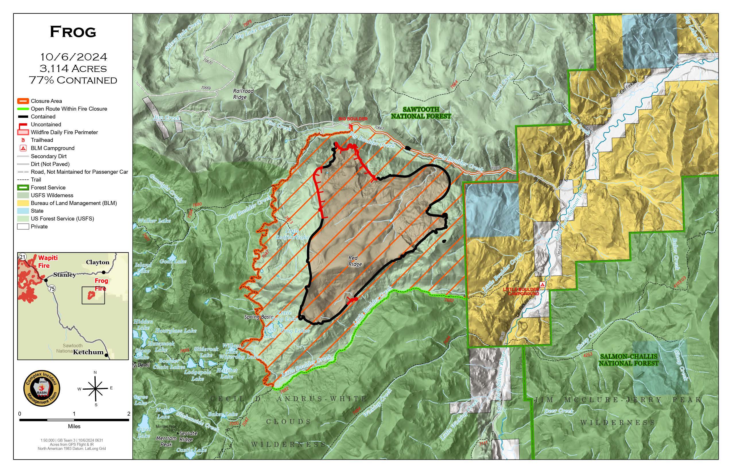
Frog Fire Statistics
- Size: 3,114 acres
- Containment: 77%
- Total Personnel: 35
- Location: east of Clayton, ID
- Reported: September 7, 2024
- Cause: Lightning
For More Information
InciWeb: https://inciweb.wildfire.gov/incident-information/idstf-frog
Facebook: https://www.facebook.com/sawtoothnationalforest
Current Situation: An infrared flight was flown over the Frog Fire last night. Crews will be verifying the containment lines and searching for the heat signature found in the Red Ridge area. Crews planned to recheck fire line on the north end of the fire.
Evacuations: There are currently no evacuations related to the Frog Fire.
Closures: The area closure in place around the Frog Fire includes FS 667 (Big Boulder Creek Road) and Trail 047 where adjacent to the closure boundary. The closure excludes FS Roads 669 and 670 and Trail 682. Hunters and recreationalists should familiarize themselves with this closure information prior to entering the vicinity. Please reference the map and read the full closure description at https://inciweb.wildfire.gov/incident-closures/idstf-frog.
Wapiti and Frog Fires Daily Update 10 06 2024
Related Incident:
Publication Type: News
Special Emphasis: Yesterday evening, Great Basin Complex Incident Management Team (CIMT) #3 took command of the Wapiti and Frog Fires.
The Air Quality Index (AQI) in the Stanley Basin is rated green today which indicates good air quality. You can check air quality and the AirNow Fire and Smoke Map at https://www.airnow.gov/.
With the changing of the closure areas, please ensure you check the boundaries prior to recreating or traveling. Many trails remain closed for public safety because they have not been cleared of potential hazards. The collection of firewood within the closure areas is prohibited; any firewood collection in open areas must be done with a valid firewood permit. For questions on firewood collection on the Sawtooth National Forest, please contact the Stanley Ranger Station at 208.774.3000.
Weather: Saturday’s winds were much calmer in the afternoon, with gust around 10 -15 compared to Friday’s gusts of 20 to 40 mph over the Wapiti Fire. Frog Fire also had calmer winds. Today temperatures will be in the high 60’s and 70’s with higher humidity.
Wapiti Fire Statistics
For More Information
Size: 125,965 acres
Completion: 80%
Total Personnel: 194
Location: near Grandjean, ID
Reported: July 24, 2024
Cause: Lightning
InciWeb: https://inciweb.wildfire.gov/incident-information/idbof-wapiti-fire
Facebook: https://www.facebook.com/wapitifireinfo2024
Linktree: https://linktr.ee/WapitiFireInfo2024
Current Situation: Yesterday, fire crews and engines were spread throughout the fire area to monitor and patrol fire activity and implement suppression actions if needed to protect values. Saturday afternoon minimal fire behavior was observed as the fire was creeping and backing down areas well within the interior and some smoldering of heavy fuels on the ground.
Today crews will be working in several areas. The Iron Creek area is available to firewood collecting for those with a permit and exemption to be in that area. A group will be placed in the Grandjean area including an engine to remove hazardous trees and debris. They will also be working on a project to restore access to the Grandjean water system. Firefighters will also be removing snags and debris along the Hwy 21 corridor. Please be cautious while traveling along Hwy 21.
Evacuations: Evacuation status for Stanley Zone 1 is currently at READY. All residents should remain alert for any change in conditions that may reinitiate an evacuation status. Sign up for Custer County CodeRED emergency notifications: text CUSTER to 99411 or enroll at https://public.coderedweb.com/CNE/BF28E45537FF. Sign up for Boise County Alert Sense emergency notifications at https://public.alertsense.com/SignUp/publicUser.aspx?regionid=1163.
For evacuation information on the Wapiti Fire, please see the Custer County Sheriff’s Facebook page, https://www.facebook.com/p/Custer-County-Sheriff-Idaho-61558947312289/, and the Boise County Sheriff’s Facebook page, https://www.facebook.com/boisecountysheriff/.
Closures: The Wapiti Fire area closure has been reduced on the southern end, excluding the Lowman, Ten Ax, Two Raven, and Sourdough communities. The closure still covers portions of the Sawtooth, Boise, and Salmon-Challis National Forests. Please reference the map and description at https://inciweb.wildfire.gov/incident-closures/idbof-wapiti-fire. Recreationalists and hunters should reference this map and obey all posted signage regarding the closure area and any related road, trail, and campground closures.
An interactive map for all closures on the Boise National Forest is found at https://experience.arcgis.com/experience/642380b0eb124c8cab6bd9ad3d7146ad/page/Overview/#data_s=id%3AdataSource_5-1888bd00a2c-layer-13-1888bd00b53-layer-16%3A82.
Frog Fire Statistics
For More Information
Size: 3,114 acres
Containment: 77%
Total Personnel: 35
Location: east of Clayton, ID
Reported: September 7, 2024
Cause: Lightning
InciWeb: https://inciweb.wildfire.gov/incident-information/idstf-frog
Facebook: https://www.facebook.com/sawtoothnationalforest
Current Situation: An infrared flight was flown over the Frog Fire last night. Crews will be verifying the containment lines and searching for the heat signature found in the Red Ridge area. Crews planned to recheck fire line on the north end of the fire.
Evacuations: There are currently no evacuations related to the Frog Fire.
Closures: The area closure in place around the Frog Fire includes FS 667 (Big Boulder Creek Road) and Trail 047 where adjacent to the closure boundary. The closure excludes FS Roads 669 and 670 and Trail 682. Hunters and recreationalists should familiarize themselves with this closure information prior to entering the vicinity. Please reference the map and read the full closure description at https://inciweb.wildfire.gov/incident-closures/idstf-frog.
Lava Fire Daily Update October 6 2024 10 06 2024
Related Incident:
Publication Type: News
Persistent heat exists within the fire interior. Friday’s strong winds fanned pockets of heat, increasing fire activity inside containment lines. The fire will continue to smolder and creep within the existing perimeter, consuming available fuels. With this slightly increased fire behavior, increased smoke production has been observed west of Lake Cascade. Smoke production will continue within the fire perimeter until significant winter snows fully extinguish remaining heat.
Current Situation:
- The Lava Fire is 88% contained at 97,560 acres with 416 personnel assigned. Continued changes in acreage are due to daily updates from fire line mapping by ground-based resources.
- A small 1/10-acre spot fire on the east side of the fire was discovered outside the fire perimeter yesterday and was quickly attacked and contained by firefighters. Pockets of fuel continue to burn in the fire’s interior.
- The fire on the northeast corner continues to slowly back down to the 435 road, which will be used as a containment feature once fire reaches it.
- Helicopters delivered 15,000 gallons of water to the fire line yesterday and the unmanned aerial system (drone) was used on the fire perimeter to detect heat sources to assist ground forces with locating hot spots.
Weather: High temperatures will be in 50s at ridgetops, 60s over rest of fire, with light winds. Southwest winds increasing on ridgetops overnight up to 20 mph. On Sunday, winds will be higher on ridge tops, with southwest winds gusting to 12 mph in the valleys, occasionally to 20 mph. Relative humidity will fall into the upper teens Sunday during the peak heat of the day. Fire behavior remains minimal, with creeping and smoldering observed. As fuels continue to dry out under unseasonably warm and dry weather, they are more likely to carry fire.
Evacuations: In Gem County, a Level 1 “READY” notice remains for residents south of South Grays Creek, along Little Weiser River Road in Indian Valley, north of South Grays Creek Road to Highway 95, and the Mesa Area. Learn more at Gem County Sheriff's Office. In Valley County, Zones 4 – 6 remain in a LEVEL 1 “READY” status. Learn more at Valley County Sheriff's Office.
Closures: The Boise and Payette National Forests adjusted the Lava Fire area closure on September 30, increasing access for the public to access areas north and south of the fire perimeter. For updated map and closure information visit Closure areas | Boise National Forest | Facebook.
Road Closures: Third Fork Road at Nesbitt Lane, Second Fork Road at Nesbitt Lane, and Nesbitt Lane. Check out updated Gem County closure information at Gem County Sheriff's Office.
Temporary Flight Restrictions:A temporary flight restriction (TFR) is in effect. View a map of the TFR and details at https://tfr.faa.gov/save_pages/detail_4_8199.html. Fire aviation response is halted or delayed if unauthorized aircrafts, including drones, enter the TFR. If you fly, we can’t! Learn more about how to use drones safely and responsibly at Home - Know Before You Fly.
Fire Info Phone: 208-780-5003 Hours: 7:00 a.m. to 7:00 p.m. Email: 2024.Lava@firenet.gov
Facebook: @LavaFire Inciweb: inciweb.wildfire.gov/incident-information/idbof-lava-fire
DALYFIREAREAROADSANDTRAILSCLOSURE Beaverhead Deerlodge 10 04 2024
Related Incident:
Publication Type: Closures
U.S. Department of Agriculture, U.S. Forest Service Beaverhead-Deerlodge National Forest
Pintler Ranger District
DALY FIRE-AREA, ROADS, AND TRAILS CLOSURE
PROHIBITIONS
Pursuant to 16 U.S.C. § 551 and 36 C.F.R. § 261.50 (a) and (b), the following is prohibited on the National Forest System (NFS) roads and trails on the Pintler Ranger Districts, Beaverhead-Deerlodge National Forest, described below and shown on the attached map incorporated into this Order as Exhibit A (the "Described Area, Roads, and Trails"):
Going into or being upon the area described in the Order. 36 CFR 261.53(e) Being on the road. 36 C.F.R. § 261.54(e).
Being on the trail. 36 C.F.R. § 261.55(a).
EXEMPTIONS
Pursuant to 36 C.F.R. § 261.50(e), the following persons are exempt from this Order:
- Any Federal, State, or Local Officer, or member of an organized rescue or firefighting resource in the performance of an official duty.
- Persons with a Forest Service special use authorization or other authorization specifically exempting them from the effect of this Order.
Described Area/Roads/Trails
The closure applies to the following National Forest System (NFS) lands, including roads and trails in the interior boundary of the area closure, depicted on the attached map (Attachment A).
All areas along State Highway 38 (Skalkaho Highway) beginning at the top of Skalkaho Pass near mile marker 26.5 (T6N,R17W, SEC 30) along State Hwy 38
to the East and turning to the north at the junction of State Hwy 38 and Rock Creek Road (T6N, R15W, SEC 31). From State Highway 38 and Rock Creek Road (County Road 102) turning north to the junction of State Highway 348 and Rock Creek Road (T7N, R16W, SEC 25) and proceeding northwesterly on Rock Creek Road (County Road 102) to the junction of USFS Road 241 (T7N, R16W, SEC 21). Following USFS Road 241 (Stony Creek Road) moving southwesterly to the junction of Little Stony Creek and Stony Creek (T6N, R17W, SEC 11). Following Little Stony Creek to the west to the top of ridge where Trail 313 Bitterroot Rock Creek Divide Trail (T6N, R17W, SEC 17). Proceeding south along Trail 313 to the intersection of State Highway 38 (Skalkaho Highway).
Trail Closure. All miles of Forest Service System trails on the Pintler Ranger District:
- Crystal Creek Trail (Tri. 8010)
- Fuse Lake Trail through Basin Gulch Trail (Tri. 8011)
- Coal Gulch Trail (Tri. 8129)
- Saphire Trail (Tri. 130)
- Stony Lake Trail (Tri. 8002)
- Bitterroot Rock Creek Divide Trail (Tri 313)
Road Closures. Forest Service System roads on the Pintler Ranger District:
- FS Road 5029
- FS Road 5028
- FS Road 78581
- FS Road 1559
- FS Road 129
- FS Road 78554
- FS Road 78555
- FS Road 78556
- FS Road 5069
- FS Road 78557
- FS Road 78563
- FS Road 5002
- FS Road 5062
- FS Road 5027
- FS Road 78562
- FS Road 78561
- FS Road 78560
- Basin Gulch Road
- FS Road 5012
- FS Road 5014
- FS Road 241
Area Closure. All of the National Forest System lands within:
- T6N, R17W, SEC 30
- T6N, R15W, SEC 31
- T7N, R16W, SEC 25
- T7N, R16W, SEC 21
- . T6N, R17W, SEC 11
- T6N, R17W, SEC 17
PURPOSE
The purpose of this Order is to ensure public health and safety during fire suppression efforts of the Pintler Fire.
IMPLEMENTATION
1. This Order shall be in effect from October 4, 2024 at 0600 until November 30, 2024 at 0001, or rescinded, whichever occurs first.
A map identifying the Described Roads and Trails is attached and made part of this Order as Exhibit A. For a digital version of this Order and Exhibit A, go to Beaverhead-DeerlodgeNational Forest -Alerts & Closures (usda.gov)
Unless otherwise expressly defined in this Order, the terms used in this Order are defined by the regulations of the Secretary of Agriculture, 36 C.F.R. Chapter II, Parts 200-299. If there are terms in this Order that are not expressly defined in the Order or 36 C.F.R. Chapter II, Parts 200-299, their meaning shall be determined by their plain language definitions.
A violation of the above prohibitions is punishable as a Class B misdemeanor by a fine of not more than $5,000 for individuals and $10,000 for organizations, or by imprisonment for not more than six months, or both. 16 U.S.C. § 551; 18 U.S.C.
§§ 3559, 3571, and 3581.
Contact the Pintler Ranger District in Philipsburg, MT, (406) 859-3211, or Beaverhead Deerlodge National Forest Supervisor's Office in Dillon, MT, (406) 683-3900, for more information about this Order.
This Order supersedes any previous Orders prohibiting the same or similar acts in/on the same Described Area/Roads/Trails.
Tiger Creek Fire Daily Update 10 05 2024
Related Incident: Tiger Creek Fire
Publication Type: News
The Tiger Creek Fire saw some growth today due to higher winds. Size at approximately 475 acres with moderate fire activity. Fire crews are continuing to work from an established anchor point on the fire and create containment line where it is feasible. Aircraft continue to be used to limit fire spread and spot fire growth in the Mill Creek Watershed. Halting the growth, active suppression of this fire and public safety will continue to be a priority task for fire crews, while limiting environmental impacts to the watershed.
Correction: A correction from prior news releases about roads closures. Access through Forest Service Road 65 up through FSR 64 to the junction with Indian Camp is closed. Government Mountain Road/FSR 6511 is closed from North Fork Walla Walla trailhead to the junction with FSR 65 at Tiger Saddle. Government Mountain Rd/FSR 6511 is open from the west up to North Fork Walla Walla trailhead.
California Interagency Complex Incident Management Team 15 has taken command of the Tiger Creek Fire as of 6:00 P.M. PST, October 5th. Additional information can be found at:
Phone number: 509-213-5793
Email: 2024.tigercreek@firenet.gov
Facebook: https://www.facebook.com/TigerCreekFire2024
InciWeb at https://inciweb.wildfire.gov/incid.../orumf-tiger-creek-fire
Weather: Weather over the weekend predicts mostly clear to sunny weather. With the humidity to rise up to 38 percent over Saturday night, with east winds up to 7 mph shifting to southeast winds up to 9 mph. Sunday is expected to keep the humidity at or above 31 percent with south winds up to 9 mph shifting to west winds up to 7 mph around 2 p.m.
Smoke: Walla Walla’s air quality for today is good and remains steady, some residents along Mill Creek may experience smoke as the fire continues to burn. Check out https://wasmoke.blogspot.com/?m=1 for more information.
The current fire danger rating is at MODERATE and public use restrictions phase A for Umatilla National Forest are in effect.
More information regarding restrictions, please contact:
Umatilla National Forest:
Information Hotline: Toll-Free (877) 958-9663
www.facebook.com/UmatillaNF
X: @UmatillaNF
http://www.fs.usda.gov/umatilla
The latest fire information will be posted on the Blue Mountains Fire Information Blog. To receive updates on fires in the Blue Mountains, follow this blog at http://bluemountainfireinfo.blogspot.com/
GARDEN FIRE UPDATE OCTOBER 5 2024 10 02 2024
Related Incident:
Publication Type: News
Fire Name: Garden Fire
Fire Size: 6,000 (estimated)
Cause: lightning
Location: approximately two (2) miles southwest of the confluence of Panther Creek and the Main Salmon River on the North Fork Ranger District in the Frank Church River of No Return Wilderness.
Fuels: grass, brush, dead and down fuels, and timber
Resources: 1 Type 1 Crew, 1 Type 2 Crew, 8 Engines, 4 overhead, and 2 Type 2 crews are enroute.
InciWeb: https://inciweb.wildfire.gov/incident-information/idscf-garden-fire
Fire situation: Firefighter and public safety is the number one priority for the Garden Fire. Fire behavior on the Garden Fire was active yesterday, the fire was creeping and running with single and group tree torching and uphill runs. Wind driven runs were associated with front moving into area. The fire was active on all sides with movement into Garden and Clear Creeks. Fire managers estimate the fire doubled in size yesterday.
Fire managers are using a point protection strategy (a wildfire response strategy, which protects specific assets or highly valued resources from the wildfire without directly halting the continued spread of the wildfire) to minimize exposure to fire personnel while protecting identified values, including private property and Forest Service infrastructure. Today, fire growth has been minimal due to the inversion layer over the fire area. Fire is anticipated to grow in the Garden Creek drainage to the ridge to the north and towards the Salmon River. Fire is currently holding in Clear Creek but is expected to grow towards Panther Creek. The presence of firefighters, primarily in the Panther Creek and Salmon River areas, is ongoing. Fire managers are continuing to look for opportunities to engage the fire direct as fuels and weather conditions change and it is safe to do so.
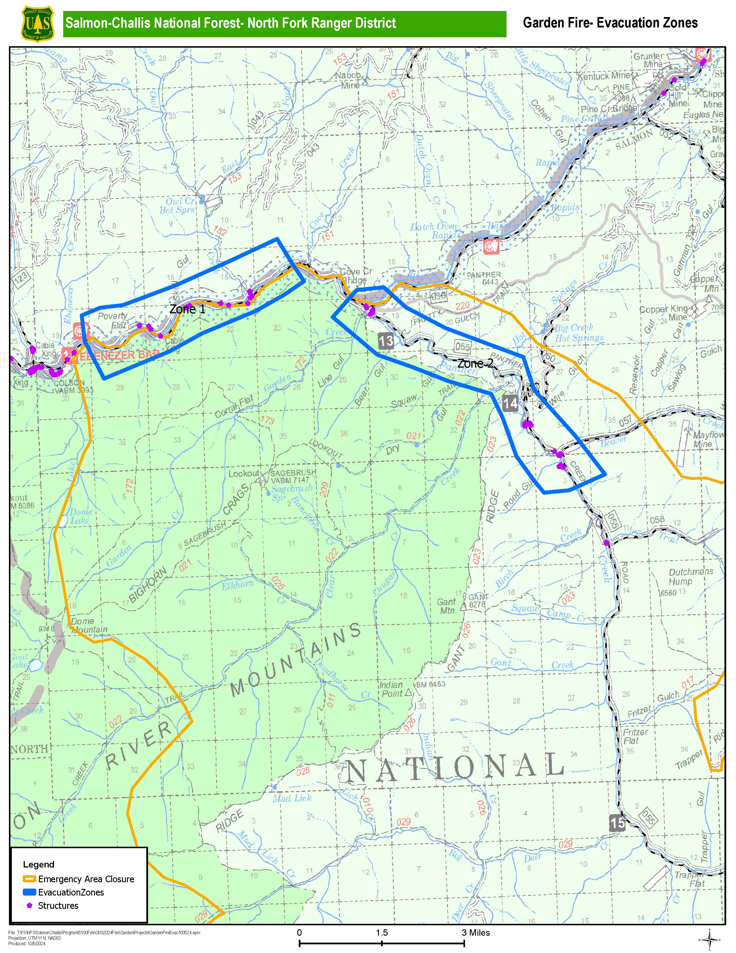
Evacuations: Lemhi County Law Enforcement, Emergency Management, and the Salmon-Challis National Forest have established 2 evacuation zones for the Garden Fire.
Zone 1: From Cove Creek to Ebeneezer Bar, downriver along the Salmon River Road #030.
Zone 2: On Panther Creek Rd #055, a half mile south of Beaver Creek Rd #057 to the Salmon River Rd #030 confluence.
ZONE 1 is in “READY” status
ZONE 2 is in “GO” status
Weather: High pressure is building in today behind an exiting cold front bringing overall light winds and much cooler temperatures. However, the cold air behind the front is very dry. So, even though afternoon highs will cool 10 to 15 degrees F from yesterday, some locations will see afternoon humidity once again below 15 percent. Humidity will increase again starting Sunday, even as temperatures warm.
Visit our website at: www.fs.usda.gov/scnf/, ‘Like Us’ on Facebook @salmonchallisnf, and ‘Follow Us’ on X @salmonchallisnf.
####
Lemhi County Announces Evacuation Zone Status 10 05 2024
Related Incident:
Publication Type: Announcement
Lemhi County Law Enforcement, Emergency Management and Forest Service have established 2 evacuation zones for this fire.
Zone 1: From Cove Creek to Ebeneezer Bar, downriver along the Salmon River Road #030.
Zone 2: On Panther Creek Rd #055, a half mile south of Beaver Creek Rd #057 to the Salmon River Rd #030 confluence.
ZONE 1 IS IN “READY” STATUS
ZONE 2 IS IN “GO” STATUS
Bighorn National Forest Order No 0202062408 signed 10 04 2024
Related Incident: Elk Fire 2024
Publication Type: Closures
Order Number: 02-02-06-24-08
U.S. Department of Agriculture, U.S. Forest Service
Bighorn National Forest
Tongue Ranger District
Fire Area Closure
Fire Area Closure
PROHIBITIONS
Pursuant to 16 U.S.C. § 551 and 36 C.F.R. § 261.50(a) and (b), the following are prohibited on the National Forest System (NFS) lands in the Tongue Ranger District, Bighorn National Forest, described below and shown on the attached map incorporated into this Order as Exhibit A (the "Described Area"):
1. Going into or being upon the Described Area. 36 C.F.R. § 261.53(e).
EXEMPTIONS
Pursuant to 36 C.F.R. § 261.50(e), the following persons are exempt from this Order:
Persons with Forest Service Permit No. FS-7700-48 (Permit for Use of Roads, Trails, or Areas Restricted by Regulation or Order), specifically exempting them from this Order or a written determination by a Forest Service authorized officer that a permit is not required under 36 C.F.R. § 251.50(e)(1) or (2).
- Any Federal, State, or Local Officer, or member of an organized rescue or firefighting force in the performance of an official duty.
DESCRIBED AREA
The Described Area starts at the northern boundary of the Medicine Wheel Ranger District and the Tongue Ranger District, running southeast to Forest System Road 26. Then following and including Forest System Road 26 west to Highway 14. Then turning north following the eastern edge of Highway 14 to Burgess Junction. Then to the west following the northern edge of Highway 14A to the junction of the Tongue Ranger District and the Medicine Wheel Ranger District boundary near Pole Creek. Then north along the district boundary following it to the mouth of Little Bighorn Canyon.
This closure includes all National Forest System Roads and Trails within the Described Area.
PURPOSE
The purpose of this Order is to protect firefighter and public safety during the response to the Elk Fire.
IMPLEMENTATION
- This Order shall be in effect from October 4, 2024 at 08:00 a.m. through December 31, 2024, at 12:00 a.m., unless rescinded.
- A map identifying the Described Area, Roads, and Trails is attached and made part of this Order as Exhibit A. For a digital version of this Order and Exhibit A, go to https://www.fs.usda.gov/detail/bighorn/alerts-notices/?cid=fseprd1090225.
- Unless otherwise expressly defined in this Order, the terms used in this Order are defined by the regulations of the Secretary of Agriculture, 36 C.F.R. Chapter 11, Parts 200-299. If there are terms in this Order that are not expressly defined in the Order or 36 C.F.R. Chapter II, Parts 200-299, their meaning shall be determined by their plain language definitions.
- A violation of the above prohibitions is punishable as a Class B misdemeanor by a fine of not more than $5,000 for individuals and $10,000 for organizations, or by imprisonment for not more than six months, or both. 16 U.S.C. § 551; 18 U.S.C. §§ 3559, 3571, and 3581.
- Contact the Bighorn National Forest Supervisor's Office in Sheridan, Wyoming,
(307) 674-2600, for more information about this Order. - This Order supersedes any previous Orders prohibiting the same or similar acts in the same Described Area.
Signed and issued on October 4, 2024.
Andrew K. Johnson, Forest Supervisor
Bighorn National Forest
RED ROCKBLACK EAGLE AND GARDEN FIRE CLOSURES 10 05 2024
Related Incident:
Publication Type: Closures
The Salmon‐Challis National Forest has implemented a new Red Rock/Black Eagle and Garden Fires Closure, Order Number: 04‐13‐24‐024 due to current fire behavior.
Description of #04-13-24-024:
DESCRIBED AREA/ROADS/TRAILS
Beginning at Ebenezer Bar on the Salmon River Road 030 south from Ebenezer Bar to Dome Mountain and continuing south to Big Deer Creek Trail 029 on Big Deer Creek, then west to Big Horn Crags Campground and crossing over into the Frank Church River of No Return Wilderness and onto the ridge to the West of Wilson Creek, then going South to Middle Fork Peak. From there along Hoodoo Meadows Trail 043 to the Salmon-Cobalt District Boundary on Camas Creek. Then following the Salmon-Cobalt District Boundary to Meyer’s Cove and continuing along that boundary to Morgan Creek Summit, then continuing along that boundary to its intersection with the Forest Boundary in the Hat Creek drainage. Following the Forest Boundary north to its intersection with the Leesburg Stage Road 65002, along this road to the Ridge Road 020, then on Sharkey Creek Road 272 to Leesburg, then due west from Leesburg to its intersection with Jureano Mountain Road 300, then along this road to its intersection with the Moose Creek Road 061, then on Jureano Lookout Road 325 following this road to its end on Trapper Ridge, then north 13 miles to the Salmon River Road 030, then west on the Salmon River Road 030 to Ebenezer Bar.
The purpose of this order is to protect public health and safety from the effects of the Black Eagle, Red Rock and Garden Fires.
This Order shall be in effect from October 5, 2024, at 8:00 am until October 31, 2024, or until rescinded.
Visit our website at: www.fs.usda.gov/scnf/, ‘Like Us’ on Facebook @salmonchallisnf, and ‘Follow Us’ on X @salmonchallisnf.
Frog Fire Closure 600 PM 10 05 2024
Related Incident: Frog
Publication Type: Closures
U.S. Department of Agriculture, U.S. Forest Service
Sawtooth National Forest, Sawtooth National Recreation Area
Frog Fire Area Closure
PROHIBITIONS
Pursuant to 16 U.S.C. § 551 and 36 C.F.R. § 261.50 (a) and (b), the following are prohibited on the National Forest System (NFS) lands, roads, trails in the Boise National Forest and Payette National Forest described below and shown on the attached map incorporated into this Order as Exhibit A (the “Described Area”):
1. Going into or being upon the Described Area. 36 C.F.R. § 261.52(e).
2. Being on the Described Roads. 36 C.F.R. § 261.54(e).
3. Being on the Described Trails. 36 C.F.R. § 261.55(a).
EXEMPTIONS
Pursuant to 36 C.F.R. § 261.50(e), the following persons are exempt from this Order:
1. Persons with Forest Service Permit No. FS-7700-48 (Permit for Use of Roads,
Trails, or Areas Restricted by Regulation or Order), specifically exempting them
from this Order or a written determination by a Forest Service authorized officer
that a permit is not required under 36 C.F.R. § 251.50(e)(1) or (2).
2. Any Federal, State, or local officer, or member of an organized rescue or fire
fighting force in the performance of an official duty.
3. Federal or State administrative personnel in the performance of an official duty.
DESCRIBED AREA, ROADS, AND TRAILS
The Described Area is all NFS Lands within the following boundaries:
- Beginning at the junction of the Sawtooth National Recreation Area boundary and Big Boulder Road FS #667 Section 9, Township 9 North, Range 17 East;
- Continuing west along Big Boulder Road FS #667 to the junction with the Big Boulder Trailhead in Section 6, Township 9 North, Range 17 East;
- Continuing south along the Livingston Mill-Castle Divide Trail, NFS Trail #047, to the junction of the Little Boulder Trail FS #682 in Section 35, Township 9 North, Range 16 East;
- Continuing east along Little Boulder Trail FS #682 to the intersection with the Sawtooth National Recreation Area boundary in Section 29, Township 9 North, Range 17 East;
- Continuing north than east along the Sawtooth National Recreation Area boundary and ending at its junction with the Big Boulder Road FS #667, in Section 9 Township 9 North, Range 17 East, Boise Meridian.
The Described Area is located in Custer County, ID
The following roads and trails bordering the Described Area are open: Forest Road #667 and NFS Trails 047 and 682.
PURPOSE
The purpose of this Order is to protect public safety during the Lava and Boulder Fires.
IMPLEMENTATION
- This Order shall be in effect from October 5, 2024 at 6:00 PM through December 31, 2024, at 11:59 PM, unless rescinded.
- A map identifying the Described Area, Roads, and Trails is attached and made part of this Order as Exhibit A. For a digital version of this Order and Exhibit A, go to https://www.fs.usda.gov/alerts/Boise/alerts-notices.
- Unless otherwise expressly defined in this Order, the terms used in this Order are defined by the regulations of the Secretary of Agriculture, 36 C.F.R. Chapter II, Parts 200-299. If there are terms in this Order that are not expressly defined in the Order or 36 C.F.R. Chapter II, Parts 200-299, their meaning shall be determined by their plain language definitions.
- A violation of the above prohibitions is punishable as a Class B misdemeanor by a fine of not more than $5,000 for individuals and $10,000 for organizations, or by imprisonment for not more than six months, or both. 16 U.S.C. § 551; 18 U.S.C. §§ 3559, 3571, and 3581.
- Contact the Sawtooth National Recreation Area office in Ketchum, ID at (208) 727-5000, or the Sawtooth National Forest Supervisor’s Office in Jerome, ID (208) 423-7500, for more information about this order.
- This Order supersedes Orders #0414-04-155 and any previous Orders prohibiting the same or similar acts in or on the same Described Area, Road, or Trail.