
Line Fire Daily Update for 10 11 2024
Related Incident: Line Fire
Publication Type: News
Location: San Bernardino County, CA Start Date: September 5, 2024
Size: 43,978 acres Percent Contained: 94%
Cause: Human Personnel: 926
CURRENT SITUATION:
Yesterday, crews continued mop-up and suppression repair operations. Strong wind gusts limited aircraft activity and forced heavy equipment to pause operations to prevent any sparks from igniting new fires. Early in the day a tree fell across Highway 38 from the El Dorado Fire burn scar in the Angelus Oaks area, and CalTrans crews were successful in clearing the roadway.
Today brings a continuation of dry weather and gusty winds, creating potential for increased activity. Siberia Creek and Bear Creeks will be closely monitored as the weather patterns and terrain are conducive to potential fire activity. The heat signatures in the Mile Creek and Cold Creek areas are well within the fire perimeter. Smoke is expected to be visible from islands of heat well within the fire perimeter. Suppression repair, mop-up, patrol, and backhaul operations will continue. Aircraft will be monitoring the fire area and provide water drops as long conditions allow. Heavy traffic is expected in the area this weekend, and we ask the public to please drive with caution as firefighters and heavy equipment will be on or near roadways.
WEATHER:
Winds will not be as strong this afternnoon; however, gusts near 14 to 23 mph can still be expected over the higher exposed ridges and along southwest to northeast aligned valleys. Our diminishing wind trend will continue through early next week. High temperatures will also be diminishing, with temperatures returning to near normal values by Thursday of next week. Poor to moderate relative humidity recoveries will continue through Sunday morning, before slowly increasing through the middle of next week.
CLOSURES:
San Bernadino National Forest has issued closures for areas surrounding the Line Fire. For more information and to see the map use this link - https://www.fs.usda.gov/detail/sbnf/?cid=FSEPRD1181411.
Highway 330 remains closed from Highland Avenue to Highway 18 as CalTrans performs repairs to the road and guardrails.
EVACUATIONS:
Evacuation warnings remain in place for the Barton Flats, Pinezanita, and Seven Oaks communities. For current updates on evacuations, visit https://www.facebook.com/sbcountysheriff.
Yellow Lake Fire Forest Closures 10 10 2024
Related Incident: Yellow Lake Fire
Publication Type: Closures
ASHLEY NATIONAL FOREST
DUCHESNE/ROOSEVELT RANGER DISTRICT
ROAD AND AREA CLOSURE
PROHIBITIONS: Pursuant to 16 U.S.C. § 551 and 36 C.F.R. § 261.50 (a) and (b), the following is prohibited on the National Forest System (NFS) roads in the Duchesne/Roosevelt Ranger District, Ashley National Forest, described below and shown on the attached map incorporated into this Order as Exhibit A (the “Described Area, Campgrounds, and Roads”):
1. Going into or being upon the Described Areas. 36 C.F.R. § 261.52(e).
2. Being on the Described Roads. 36 C.F.R. § 261.54(e).
EXEMPTIONS:
Pursuant to 36 CFR 261.50(e), the following persons are exempt from this Order:
1. Persons with Forest Service Permit No. FS‐7700‐48 (Permit for Use of Roads or Areas Restricted by Regulation or Order), specifically exempting them from this Order or a written determination by a Forest Service authorized officer that a permit is not required under 36 C.F.R. § 251.50(e)(1) or (2).
2. Any federal, state, or local officer, or member of an organized rescue or firefighting force in the performance of an official duty.
3. Federal or state administrative personnel in performance of an official duty.
AREA CLOSURE DESCRIBED:
1. The area described as follows, beginning near Rhoades Canyon at the west Ashley National Forest boundary with the Uinta Wasatch Cache National Forest, thence north and then east along boundary to the intersection of the Highline Trail (FST 025) at Rocky Sea Pass, then following the Highline Trail to Dead Horse Pass, then southeast along the ridgetop to Explorer Peak, continuing along ridgeline south to Kweewahgut Peak, then southeast following ridgeline to Cleveland Peak, then southeast to Brown Duck Mountain, proceeding across Tworoose Pass southeast to Rock Creek Peak, then south along Miners Gulch road to the Rock Creek Road, then following Rock Creek Road (FSR 134) to Forest boundary, and continuing west to Forest west boundary near Rhoades Canyon.
ROAD CLOSURES DESCRIBED
1. FSR 144 (North Fork of the Duchesne Road) from the forest boundary to its terminus.
2. Rhoades Canyon Road (FSR 174) starting at the forest service boundary to its terminus.
3. Blind Stream Road (FSR 135) starting at the forest service boundary to its terminus.
4. Burnt Ridge Road (FSR 416) starting at the forest service boundary to intersection with FSR 197.
5. Log Hollow Road (FSR 197) starting at the forest service boundary to its terminus.
6. Rock Creek Road (FSR 134) starting at the forest service boundary to its terminus.
7. Miners Gulch Road (FSR 222) starting at intersection of Rock Creek Road to its terminus.
PURPOSE:
The purpose of this Order is for public health and safety due to Yellow Lake Fire. Wildfire behavior can be unpredictable and due to the close proximity of this fire it is in the publics best interest to remain out of this area.
IMPLEMENTATION:
1. This Order shall be in effect from October 10, 2024, at 12:00 pm through December 31, 2024, at 12:00 am.
2. A map identifying the Described Area and Roads is attached and made part of this Order as Exhibit A.
3. Unless otherwise expressly defined in this Order, the terms used in this Order are defined by the regulations of the Secretary of Agriculture, 36 C.F.R. Chapter II, Parts 200‐299. If there are terms in this Order that are not expressly defined in the order or 36 C.F.R. Chapter II, Parts 200‐299, their meaning shall be determined by their plain language definitions.
4. A violation of the above prohibitions is punishable as a Class B misdemeanor by a fine of not more than $5,000 for individuals and $10,000 for organizations, or by imprisonment for not more than six months, or both. 16 U.S.C. § 551; 18 U.S.C. §§ 3559, 3571, and 3581.
5. For more information about this Order, contact the Duchesne/Roosevelt Ranger District located in Duchesne, Utah, telephone (435) 738‐2482 or the Ashley National Forest Supervisor’s Office located in Vernal, Utah, telephone (435) 789-1181.
6. This Order supersedes any previous Order(s) prohibiting the same, or similar acts, in/on the Described Area and Roads.
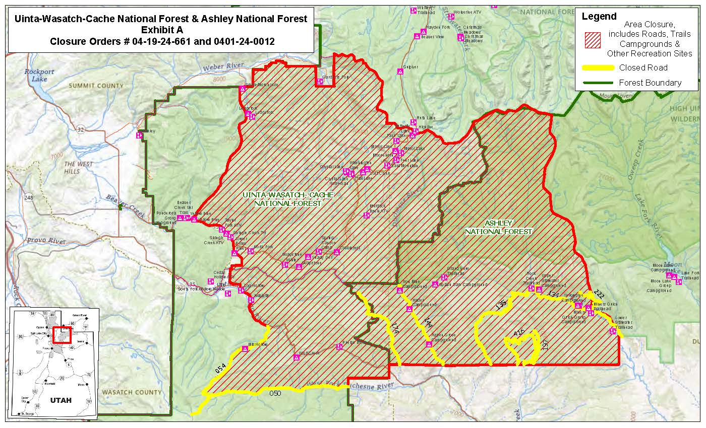
Uinta-Wasatch-Cache National Forests
Heber-Kamas Ranger District
Yellow Lake Fire Area and Road Closures
PROHIBITIONS
Pursuant to 16 U.S.C. § 551 and 36 C.F.R. § 261.50 (a) and (b), the following acts are prohibited on the National Forest System Yellow Lake Fire Area and Roads in the Heber-Kamas Ranger District, Uinta-Wasatch-Cache National Forests. Described below and shown on the attached map incorporated into this Order as Exhibit A. This Order will be in effect October 10, 2024, and shall remain in effect until December 31, 2024, unless rescinded.
1. Being in or upon the Area, including all Campgrounds, Trails, Trailheads and Parking Area/Lots as described below and shown on the attached map. This includes all pedestrian, hikers, equestrian, bicycles, and any type of motorized vehicle. [36 CFR 261.52 (e)] and [36 CFR 261.53(e)]
2. Being in or upon the roads as described below and shown on the attached map. This includes all pedestrian, hikers, equestrian, bicycles, and any type of motorized vehicle. [36 CFR 261.54 (e)] and [36 CFR 261.53(e)]
EXEMPTIONS
Pursuant to 36 C.F.R. § 261.50(e), the following persons are exempt from this Order:
1. Persons with Forest Service Permit specifically exempting them from this Order or a written determination by a Forest Service authorized officer that a permit is not required under 36 C.F.R. § 251.50(e)(1) or (2).
2. Any federal, state, or local officer, or member of an organized rescue or firefighting resource in the performance of an official duty.
3. Federal or state administrative personnel in performance of an official duty.
DESCRIBED The Yellow Lake Fire area closure includes all roads, trails, trailhead, parking area/lots, and campgrounds. Starting at the Pine Valley campground going West on the north side of Highway 150 to the Yellow Pine trailhead (Forest Service Trail #240) north along the trail past Castle Peak to Box Canyon (Forest Service ATV Trail #305) continuing north along Mud Lake Flats Road (Forest Service Road #030) to Smith and Morehouse Reservoir (Forest Service Road #033) to the forest service boundary east along the forest boundary to the district boundary between the Heber-Kamas Ranger District and the Evanston Ranger District east along the boundary to the Highline Trailhead continuing east along the ridge line to the forest boundary at Rocky Sea Pass south along the forest boundary across Highway 35 to the West Fork of the Duchesne River Road (Forest Service Road #050) going west along the West Fork of the Duchesne River Road (Forest Service Road #050) to the intersection with the Mill Hollow Road (Forest Service Road #054) then going north along the Mill Hollow Road (forest Service Road #054) to Highway 35 then going northwest on the north side of Highway 35 following the forest boundary for approx. 3 miles then north along the Forest Boundary to Pine Valley group campground located in Township 1 North, Range 7 East, Section 36; Township 1 North, Range 8 East, Sections 26-35; Township 1 North, Range 9 East, Sections 19-21, 27-34; Township 1 South, Range 10 East, Sections 19-21, 28; Township 1 South, Range 7 East, Sections 1, 12-13, 24-25, 35-36; Township 1 South, Range 8 East, Sections 1-36; Township 1 South, Range 9 East, Sections 3-10, 13-24, 26-35; Township 2 South, Range 7 East, Sections 1-3, 10-17, 20-27, 35-36; Township 2 South, Range 8 East, Sections 1-36; Township 2 South, Range 9 East, Sections 2-10, 15-21, 28-33; Township 3 North, Range 8 West, Sections 2-11, 17-19, 30-3; Township 3 North, Range 9 West, Sections 1-4, 9-16, 20-30, 32-36; Township 3 South, Range 7 East, Sections 1-2, 11-14, 24-25, 36; Township 3 South, Range 8 East, Sections 1-36; Township 3 South, Range 9 East, Sections 4-8, 17-21, 27-34; Township 4 North, Range 8 West, Sections 19, 21-22, 27-35; Township 4 North, Range 9 West, Sections 22-27, 34-36; Township 4 South, Range 7 East, Sections 1, 11-14, 22-24; Township 4 South, Range 8 East, Sections 2-10, 15-19; Township 4 South, Range 8 East, Sections 4-6 all within the Salt Lake Meridian as shown on the attached map and Township 1 North, Range 10 West, Sections 1-2, 9-17, 19-30; Township 1 North, Range 11 West, Sections 21-29, 32-36; Township 1 North, Range 9 West, Sections 5-10, 15-21, 30; Township 2 North, Range 10 West, Sections 13, 24; Township 2 North, Range 8 West, Section 6; Township 2 North, Range 9 West, Sections 1-10, 15-19, 29-30, 32-33 all within the Uintah Based Meridian as shown on the attached map
PURPOSE To Provide for public and firefighter safety during the suppression of the Yellow Lake Fire.
IMPLEMENTATION
1. This Order will be in effect when signed October 10, 2024, and shall remain in effect until December 31, 2024, unless rescinded.
2. A map identifying the road is attached and made part of this Order as Exhibit A. For a digital version of this Order and Exhibit A, go to Uinta-Wasatch-Cache National Forest - Alerts & Notices (usda.gov).
3. Unless otherwise expressly defined in this Order, the terms used in this Order are defined by the regulations of the Secretary of Agriculture, 36 C.F.R. Chapter II, Parts 200-299. If there are terms in this Order that are not expressly defined in the Order or 36 C.F.R. Chapter II, Parts 200-299, their meaning shall be determined by their plain language definitions.
4. A violation of the above prohibitions is punishable as a Class B misdemeanor by a fine of not more than $5,000 for individuals and $10,000 for organizations, or by imprisonment for not more than six months, or both. 16 U.S.C. § 551; 18 U.S.C. §§ 3559, 3571, and 3581.
5. Contact the Heber-Kamas Ranger District, Kamas office in Kamas, Utah (435) 783-4338, Heber office in Heber, Utah (435) 654-0470 and National Forest Supervisor’s Office in South Jordan, Utah (801) 999-2103, for more information about this Order.
Order Number: 04-19-24-661
6. This Order supersedes any previous Orders prohibiting the same or similar acts in/on the Area, and Roads.
Prescribed Fire Update New Potential Project Announced 10 11 2024
Related Incident: American Creek Prescribed Fire
Publication Type: News
Here’s the latest for prescribed fires on the Carson National Forest:
- Fire crews conducted another day of ignitions on the La Jara and Apache Prescribed Fire, treating 544 acres near Forest Road 5 in La Jara Canyon. More ignitions are planned for tomorrow. The public should expect to see smoke throughout the day.
- Managers are looking at the possibility of beginning the Powderhouse Prescribed Fire in Valle Vidal as early as Oct. 13. More details are below.
- Crews continue to patrol and monitor the Sotano and American Creek prescribed fires, which were completed yesterday and last week, respectively. This work includes the use of an uncrewed aerial system, or drone, outfitted with infrared to detect heat.
Powderhouse Prescribed Fire
The prescribed fire unit is 8,288 acres and located on the western side of Valle Vidal near Costilla Dam to the north and Holman Creek to the south. It is bounded by forest roads 1900, 1950, old logging roads and built control line (map).
Regular fire helps restore many of the forest’s ecosystems and can reduce the threat of a catastrophic wildfire severely affecting the recently restored population of Rio Grande cutthroat trout, a project over 20 years in the making. It also helps maintain productive rangelands that support local grazers.
The project is an effort of the Wildfire Crisis Strategy, a national initiative to reduce the threat of wildfire to communities, infrastructure (e.g. Costilla Dam), and natural resources (e.g. Rio Costilla Watershed). The Enchanted Circle Landscape is one of the strategy’s priorities.
Stay Updated
Residents and visitors are encouraged to keep updated with prescribed fire and other Carson National Forest news by joining the forest news release list, among other options like checking InciWeb, following on social media and using NMFireInfo.com.
More information about prescribed fires, including smoke-readiness tips, are available online.
Rail Ridge Media Release 10 10 2024
Related Incident:
Publication Type: Announcement
Media Release
October 10, 2024
Forest Closures, Fire Restrictions and Evacuation Levels Remain in Place Near the Rail Ridge Fire
For public and firefighter safety please respect the current closure areas, fire restrictions and evacuation levels.
Forest & BLM Closures / Fire Restrictions / Evacuation Levels / Map of ODFW hunting management unit areas overlayed with forest closures and the fire footprint can be found at: https://linktr.ee/RailRidgeFire.
Visitors looking to hunt or recreate on public lands over the holiday weekend should be aware that Forest and BLM closures around the Rail Ridge Fire remain in place. These closures are in place to protect members of the public from hazards such as damaged roads, hazard trees, burning stumpholes and unstable ground. Fire crews and heavy equipment remain present on all sides of this fire. Although the weather forecast is more favorable for fire suppression than it has been in several days, the area has not had any measurable precipitation and the potential for fire activity to increase remains a factor.
Check for current fire regulations before visiting public lands. You will be helping our firefighters by doing your part, and remember it only takes one spark! The majority of human starts are accidental, be prepared with a fire extinguisher, water and a shovel when out recreating. Campfires in some areas are restricted, although a propane camp stove may be an acceptable alternative.
Evacuation levels remain in place for Grant, Wheeler and Crook Counties, due to the uncontained active fire on the landscape. Know Before You Go and check for changes in levels.
Rail Ridge Fire Information:
Orocf Rail Ridge Information | InciWeb (wildfire.gov)
Contact
Rail Ridge Public Information
Email: 2024.railridge@firenet.gov
Phone: 541-208-7111
Central Oregon Wildfire Information can be found at centraloregonfire.org.
Bingham Fire Emergency Area Closure 10 10 2024
Related Incident: Bingham Fire
Publication Type: Closures
WILL AMETTE NATIONAL FOREST
DETROIT RANGER STATION
ORDER# 06-18-04-24-50
FOREST ORDER
BINGHAM FIRE EMERGENCY AREA CLOSURE
Pursuant to 16 U.S.C. § 551 and 36 CFR § 261.50 (a) and (b), and to provide for public safety, the following acts are prohibited on the National Forest System ("NFS") areas, roads, and trails described below within the administrative boundaries of the Willamette National Forest. Refer to Exhibit A for the map and Exhibit B for trails and recreation sites that are closed. This Order supersedes Order# 06-18-04-24-50 and is effective on October 10th, 2024, through May 31, 2025, unless otherwise rescinded sooner.
PROHIBITIONS:
- Being on the road. 36 CFR § 261.54(e)
- Being on a trail. 36 CFR § 261.SS(a)
- Entering into or being upon National Forest System Lands closed for the protection of public health and safety. 36 CFR § 261.53(e)
CLOSURE AREA:
The closure area is located within the State of Oregon, Linn County, and within the Administrative Boundaries of the Willamette National Forest. The closure applies to the NFS areas, roads, and trails and trailheads described below. The closure area is depicted on the attached map, which is incorporated into this order as "Exhibit A." All areas, roads, trails, campgrounds, and recreation sites in this closure area are closed. Recreation sites, trails, campgrounds and roads closed by this order are depicted in "Exhibit B."
AREA CLOSURE DESCRIPTION:
The closure boundary starts at the junction of Highway 22 and Forest Service Road 2253 (Minto). It includes the entirety of FSR 2253 (Minto) and proceeds East along the North bank of Minto Creek, South of Bingham Lake, and continues east to the junction of Forest Service Trail 3493 (Lake of the Woods) and FST 3440 (Hunts Creek). From there it continues south on the east side of Lake of the Woods, and continues southwest, following the eastern side of FST3493 (Lake of the Woods) until the intersection of FST 3437 (Minto Pass Trail). From there it follows and includes FST3436 (Marion Lake). From the FST3436 (Marion Lake) Trailhead it then follows and includes Forest Service Road 2255 in its entirety until it intersects with Highway 22. From there it follows Highway 22 until it intersects with FSR 2253 (Minto), but does not include Highway 22.
EXEMPTIONS:
Pursuant to 36 CFR § 261.50(e)(1) and (4), the following persons are exempt from this Order:
( 1) Persons with Forest Service Permit No. FS-7700-48 (Permit for Use of Roads, Trails, or Areas Restricted by Regulation or Order) specifically exempting them for this Order.
(2) Any Federal, State, or Local Officer, or member of organized rescue or fire fighting force in the performance of an official duty.
These prohibitions are in addition to the general prohibitions in 36 CFR Part 261, Subpart A
Violations of these prohibitions are punishable by a fine of not more than $5,000.00 for an individual or $10,000.00 for a corporation or imprisonment for not more than six months or both. 16 U.S.C. § 551 and 18 U.S.C. § 3551, 3571, and 3581.
Executed in Springfield, Oregon on this 10th day of October 2024.
Donna Mickley
Acting Forest Supervisor
Willamette National Forest
Willamette National Forest Issues Reduced Closure Order 10 10 2024
Related Incident: Bingham Fire
Publication Type: News
Due to successful firefighting efforts and favorable weather conditions, the Willamette National Forest reduced the emergency closure area for the Bingham Fire on Oct. 10, 2024, reopening popular recreation sites. The closure order, which is for public and firefighter safety, is in effect through Jan. 1, 2025, unless modified sooner.
The Bingham Fire, located in the Mount Jefferson Wilderness east of Marion Forks, was reported Sept. 30, 2024, and is approximately 199 acres in size and 65% contained.
Recreation sites now open include Pamelia Lake Trail #3439 and Trailhead, Pine Ridge Trail #3443 and Trailhead, Blue Lake Trail #3422, and Grizzly Peak Trail #3428. Highway 22 and the Pacific Crest Trail through the Mount Jefferson Wilderness remain open.
Trailheads and trails that remain closed include Bingham Ridge Trail #3421 and Trailhead, Independence Rock Trail #3431 and Trailhead, Marion Lake Trail #3436 and Trailhead, and Lake of the Woods Trail #3493.
For a map of the Bingham closure area and a complete list of recreation sites and roads included in the order, visit the Willamette National Forest website at https://www.fs.usda.gov/alerts/willamette/alerts-notices.
The Linn County Sheriff’s Office also modified an evacuation order for a large area of the Mount Jefferson Wilderness. For details visit https://www.linnsheriff.org/wildfire_live_updates/
Please be aware of current restrictions on the Willamette National Forest before heading out into the forest and share information with others. As fire restrictions change, information will be available at https://www.fs.usda.gov/main/willamette/fire.
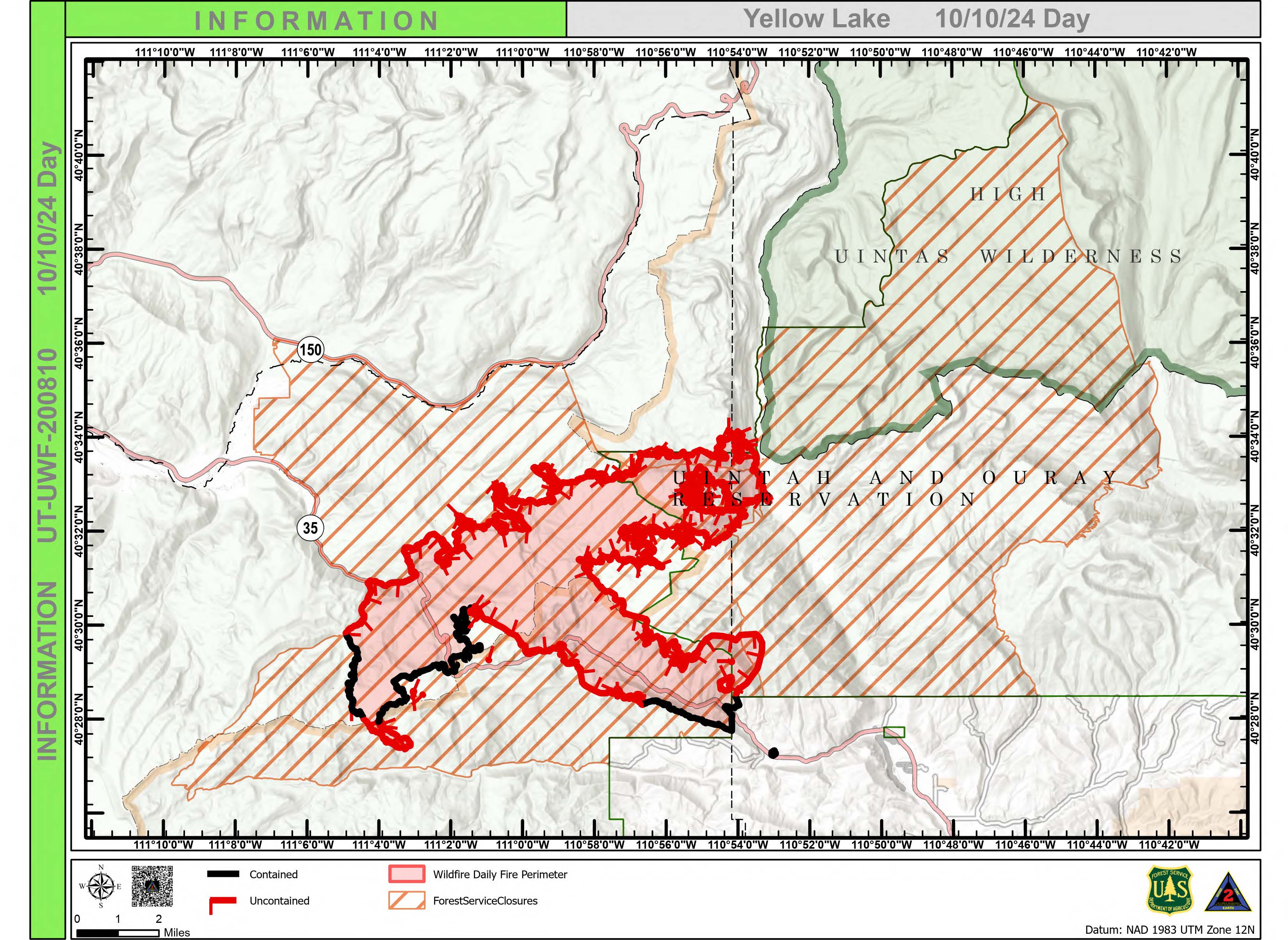
Yellow Lake Fire 10 10 2024
Related Incident: Yellow Lake Fire
Publication Type: News
A town hall meeting, organized by Duchesne County Fire and Office of Emergency Services, is scheduled for 6 PM tonight at the old high school gym in Tabiona.
Weather remains the biggest challenge on the Yellow Lake Fire as unseasonably high temperatures and erratic winds continue to fuel fire behavior.
The fire is showing the most active growth in the southeast corner. As fire moves out of the Iron Mine area and into North Fork of the Duchesne, firefighters are working to enhance the fuel breaks and slow progression. Crews are focused on prepping and protecting structures and other values at risk in these areas. To date, no structures have been lost.
Work is progressing near Soapstone Road on the north, but there has been an increase in fire behavior and smoke in the area due to increased winds. As the fire starts to make a push towards the north into Murdock Basin, the Forest is intending to make changes to the forest closure to protect the public as the fire grows.
More of the southern perimeter has been contained, except for the Heart Lake area where crews continue to progress to build containment line aided by the use air resources. Retardant and water drops can often slow progression enough for ground crews to go direct for fire suppression.
Along the southeast corner, there has been little growth towards Hanna. With the predicted weather and behavior there may be an increase in smoke. This is anticipated, and fire operations are planned accordingly.
Crews continue to patrol and secure the western edge along Mill Hollow Road and containment is holding. While the smoke is impacting communities to the west, the threat to this area is decreasing.
Three scooper planes were used throughout the afternoon, drawing water from Strawberry Reservoir to support ground crews. Air attack is being used in conjunction with ground crews in full suppression operations.
Evacuation Areas: The North and West Forks of the Duchesne River, and Granddaddy Lakes area are under a mandatory GO evacuation meaning all residents, hunters, and recreationists must leave and stay out of the area. Hanna are under a SET order, advising residents to have bags packed and be prepared to evacuate if necessary. For updated evacuation zones, please visit:
https://emergency-management-operations-wasatch.hub.arcgis.com/
https://tricountyemergencyalert.genasys.com/portal/en
Forest Closures:
- Effective October 3, 2024, a closure has been implemented on the Uinta-Wasatch-Cache National Forest due to the Yellow Lake Fire. This Order will be in effect October 3, 2024, and shall remain in effect until October 31, 2024, unless rescinded.
- Effective October 6, 2024, a closure has been implemented on the Ashley National Forest due to the Yellow Lake Fire. This closure will remain in place through December 31, 2024 or until rescinded, for public safety.
- To view the Forest Orders and Maps, visit our website at: https://www.fs.usda.gov/Internet/FSE_DOCUMENTS/fseprd1208350.pdf
https://www.fs.usda.gov/Internet/FSE_DOCUMENTS/fseprd1208878.pdf
Linn County Sheriffs Office Reduces Level 3 Evacuation Area 10 10 2024
Related Incident: Bingham Fire
Publication Type: Announcement
Effective at noon Thursday, October 10, the existing Level 3 (GO) evacuation alert is reduced, and access continues to be restricted to the following trails and road systems, as well as all areas in Level 3 reflected on the Linn County Fire Map https://tinyurl.com/LinnCoFireMap:
- FSR 2253 after the junction with Minto Road (FSR 2253-125) (main fire access)
- FSR 2255 (due to road brushing/prep)
- Bingham Ridge Trail #3421
- Lake of the Woods Trail #3493
- Marion Lake Trail #3436
- Independence Rock Trail
The areas being reduced from the existing Level 3 evacuation alert are reduced to a Level 2 (GET SET) evacuation alert. All existing Level 2 evacuation areas remain in place.
Sheriffs around the State of Oregon are tasked with ensuring the safety of the public and are responsible for enacting and enforcing any evacuation levels when emergencies or other threats present the need. These evacuation alert decisions are made in coordination with emergency management teams, partner law enforcement and fire agencies, and public stakeholder input. Additionally, closures to the forest and wilderness area are enacted by the Oregon Department of Forestry and/or the National Forest Service, when circumstances and conditions necessitate a closure to a forest area.
Please refer to the Linn County Fire Map for full details of the issued evacuation area (which will appear in red).
Elkhorn Fire Update 10 10 2024
Related Incident: Elkhorn Fire
Publication Type: News
Elkhorn Fire 10/10/2024
Acreage: 10,313
Containment: 60%
Yesterday, more accurate maps were created utilizing satellite imagery that showed a decrease in estimated acreage. The map will continue to be refined as more information is gathered.
The USDA Forest Service Dakota Prairie Grasslands issued a National Forest System Area and Roads closure order for affected areas by the Elkhorn Fire. The full closure can be found at https://www.fs.usda.gov/alerts/dpg/alerts-notices/?aid=91424 To clarify, hunting permits or licenses do not allow access to roads and areas within the closure area.
Resources assigned to the Elkhorn Fire and local responders responded to the Pasture 10 Fire, where forward progress has stopped, and crews are continuing to strengthen containment lines. Fire prevention vigilance is important, and we appreciate your cooperation.
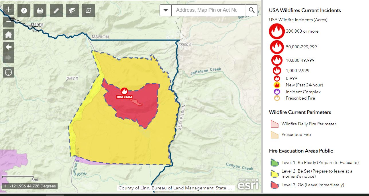
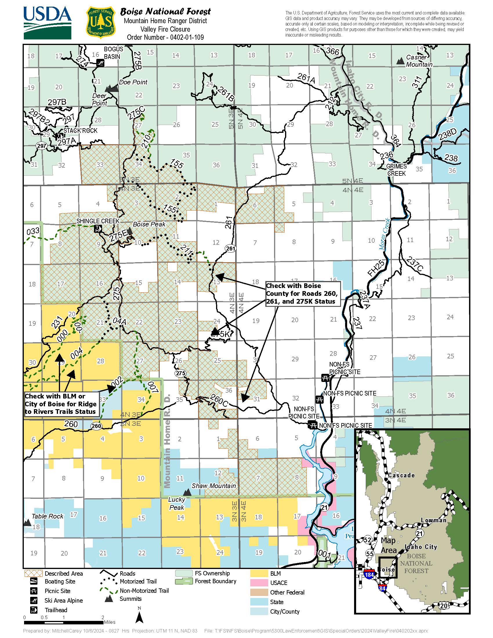
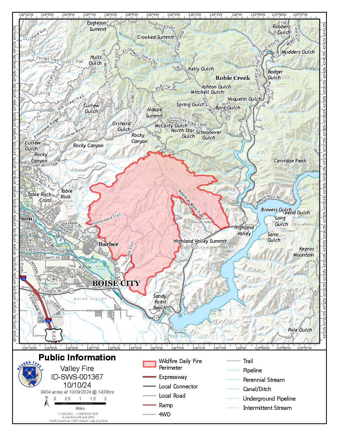
Valley Fire Update 10 10 2024
Related Incident: 2024 Valley Fire
Publication Type: News
Incident Activity: Weather conditions were more favorable than expected Wednesday with steady wind that assisted firefighting efforts. There was an increase in fire activity and smoke in pockets of timber a safe distance from the community of Robie Creek. Helicopters were used to make continuous water drops to secure containment lines and support ground crews. Crews remain focused on the most active area of the fire in the north and northeast portion where the fire is closest to the Robie Creek community. Today crews will again be addressing burning timber near containment lines in the area. Fire containment has been successful on the south and west portions of the fire visible from Boise. Those areas remain carefully monitored. The fire is under the jurisdiction of the Idaho Department of Lands and is a full fire suppression effort.
Weather: Cooler temperatures with highs in the mid-70s in the Valley Fire area. West-moving winds could reach about 8 mph in the afternoon. No rain is in the forecast this week, but humidity levels are increasing which benefits firefighting efforts.
Evacuations and Closures: No primary residences have been lost. The Robie Creek area is still in a "Ready" or Stage 1 evacuation status. There is a Boise National Forest Valley Fire Area, Road and Trail Closure. Contact the Mountain Home Ranger District at 208-587-7961. Idaho Department of Parks and Recreation has an interactive map that shows trails impacted by the Valley Fire. For the safety of the public and the efficiency of firefighting crews, all roads and trails on the Boise Front segment of the Boise River WMA west of Highway 21 and north of Warm Springs Avenue are closed to all entry until further notice. This closure also extends to all travel off roads and trails.
Valley Fire Overview: The fire was reported Friday, October 4, 2024, about 1 mile east of Boise on the north side of Idaho State Highway 21. The fire was very visible from East Boise as it burned in mostly grassy fuels in the Boise Foothills. Quick work on initial attack stopped the fire from reaching nearby homes. The Bureau of Land Management, Boise District, along with the Boise Fire Department and other local agencies led initial firefighting efforts. Resources include hotshot crews, engines, dozers, and aerial resources. No injuries have been reported.
Recreation Safety: Valley Fire crews and equipment are using Hwy 21 and other area roads as part of firefighting efforts. The highway is open and not threatened by the Valley Fire, but please use caution. Hunting season, recreation opportunities outside of closure areas, and a three-day weekend for many is expected to increase public use of roads and trail systems. Please honor closures and be aware that fire damage to the landscape poses safety risks such as damaged trees and loose soil.