
Yellow Lake Fire Update 10 12 2024
Related Incident: Yellow Lake Fire
Publication Type: News
Yellow Lake Fire
Incident Update October 12, 2024
Size at time of update: 26,197
Containment: 21%
Personnel: 848
Start: Saturday, September 28, 2024
Cause: Undetermined
Location: 10 miles southeast of Francis, Utah
Full suppression strategy continues today on the Yellow Lake Fire using ground crews, supported by numerous aircraft. Five scooper planes worked throughout the day on Friday dropping water to slow fire progression on the east side of the fire. Retardant drops were also used where needed. This allows ground crews to safely enter more active portions of the fire. Dozer and hand lines can then be constructed down to the soil level where water and retardant often cannot reach due to tree canopy, brush, ground litter, and other obstructions. The north and east sides remain most active and are the current priorities.
Eight log decks have been destroyed within timber sale areas. They are considered “structures” according to reporting requirements but, no building structures have been damaged to date.
Fire crews were able to catch a spot fire overnight on Iron Mine Mountain. This fire line is being reinforced today.
Burning snags, isolated interior torching and wind driven runs will occur today as southwest winds dominate fire behavior. Smoke plumes are anticipated. Wind direction should be favorable on the south edge of the fire. Increased spotting potential could occur today if opposing canyon winds in the North Fork of the Duchesne drainage clash with southwest winds.
Minimal activity has been observed on the west side of the fire perimeter.
A public meeting to present information on the Yellow Lake Fire is planned for 3:00 p.m. on Sunday, October 13th, at the Kamas Middle School Auditorium.
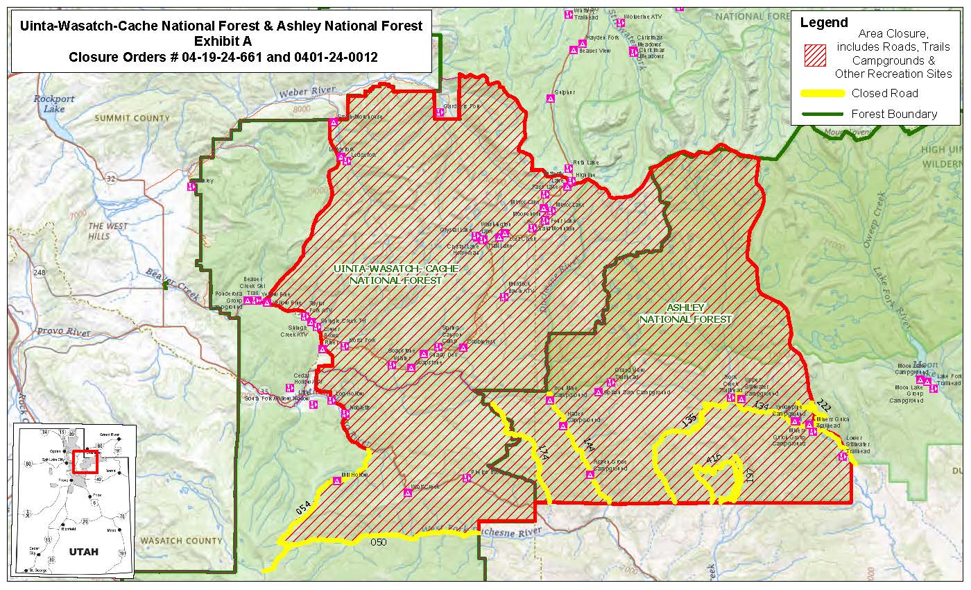
Forest Closures:
- Updated October 11, 2024, a closure has been increased on the Uinta-Wasatch-Cache National Forest due to the Yellow Lake Fire. This Order shall remain in effect until October 31, 2024, unless rescinded.
https://www.fs.usda.gov/Internet/FSE_DOCUMENTS/fseprd1208350.pdf - Updated October 11, 2024, a closure has been increased on the Ashley National Forest due to the Yellow Lake Fire. This closure will remain in place through December 31, 2024, or until rescinded, for public safety.
Evacuation Areas: The North and West Forks of the Duchesne River, and Granddaddy Lakes area are under a mandatory GO evacuation meaning all residents, hunters, and recreationists must leave and stay out of the area. Hanna is under a SET order, advising residents to have bags packed and be prepared to evacuate if necessary.
For updated evacuation zones, please visit:
https://emergency-management-operations-wasatch.hub.arcgis.com/
https://tricountyemergencyalert.genasys.com/portal/en
https://www.fs.usda.gov/Internet/FSE_DOCUMENTS/fseprd1208878.pdf
Valley Fire Update 10 12 2024
Related Incident: 2024 Valley Fire
Publication Type: News
Fire Containment Line Breakdown: There are 22 miles of dozer line. 21 miles of that line is considered contained which means the fire is not expected to cross that line moving forward. There are several miles of handline which is line built by firefighters along the fire perimeter. There is around 7 miles of uncontained line. The public may notice changes in the landscape because of this fire suppression work. That work was successful in preventing the fire from reaching homes in Boise. Part of the work of the Incident Management Team is to assist with addressing the impact of firefighting actions.
Incident Activity: Helicopter water drops continued much of the day Friday. Fire activity is still a safe distance from the community of Robie Creek. Crews remain in the south and west portions of the fire visible from Boise monitoring the area and extinguishing any remaining hot spots and talking with the public. The fire is under the jurisdiction of the Idaho Department of Lands and is a full fire suppression effort. No injuries have been reported.
Fuels and Fire Behavior Advisory: Fuels, such as grasses and timber, are back to critically dry conditions in the Great Basin, with record-level dry conditions in many cases. Extreme Fire Behavior is observed on existing fires as well as new and emerging fires.
Weather: Dry conditions continue with highs averaging 70 degrees in the Valley Fire area and light winds.
Evacuations and Closures: No primary residences have been lost. The Robie Creek area is still in a "Ready" or Stage 1 evacuation status. There is a Boise National Forest Valley Fire Area, Road and Trail Closure. Contact the Mountain Home Ranger District at 208-587-7961. For the safety of the public and the efficiency of firefighting crews, all roads and trails on the Boise Front segment of the Boise River WMA west of Highway 21 and north of Warm Springs Avenue are closed to all entry until further notice. This closure also extends to all travel off roads and trails.
Valley Fire Overview: The fire was reported Friday, October 4, 2024, about 1 mile east of Boise on the north side of Idaho State Highway 21. The fire was very visible from East Boise as it burned in mostly grassy fuels in the Boise Foothills. Quick work on initial attack stopped the fire from reaching nearby homes.
No Fly Zone: A privately-operated drone entered the restricted fire area this week. Flying drones in the fire area is NOT ALLOWED. Drones pose a safety risk for firefighting aircraft and can result in having to stop air operations. Please remember, if you fly, we can’t.
Rail Ridge Daily Update 10 12 2024
Related Incident:
Publication Type: Announcement
Rail Ridge Fire Update
October 12, 2024
Central Oregon Wildfire Information: centraloregonfire.org
Email: 2024.railridge@firenet.gov – Phone: 541-208-7111
Social Media, Evacuation and Closure Information: https://linktr.ee/RailRidgeFire
Acres: 174,438 – Containment: 89% – Detection: 09/02/24 – Cause: Lightning – Personnel: 616
Operational Update: Yesterday, cool and humid weather, combined with cloud cover led to another day of minimal fire behavior. Suppression repairs continued, including removal of hazard trees and road grading. The firefighters are prioritizing patrolling contained lines while monitoring mop-up of stump holes and hot spots that are still smoldering. UAS checked for heat over the uncontained pieces of line on the northern fire edge and confirmed that the perimeter is secure, and these areas are now considered contained. Helicopters assisted in giving fire behavior analysts a flight to assess the current fire behavior activity as well as flights to assist in communication tower support.
The uncontained fire within Cottonwood Creek and Cougar Mountain continues to spread at slow rates with minimal fire behavior. An indirect strategy continues to be the primary plan, due to significant hazards to firefighters if they attempted direct actions. These hazards include steep, remote, rugged terrain, a high density of snags and heavy fuel loading making travel on foot difficult. The indirect strategy provides firefighters the ability to use road systems and heavy equipment in more favorable terrain and fuels.
Today, weather is expected to be similar to yesterday with lower relative humidity in the afternoon. Primary fire behavior at this time is backing, flanking, and isolated torching. Fuels remain dry and active fire behavior is possible. Widely scattered interior heat sources continue to smolder due to long-term drying. These interior flare-ups will continue to produce smoke for days to come. Heavy equipment and fire crews will begin to prepare FS Road 3850 into containment line along the western edge of the active fire area. To the north, dozers and crews are preparing containment line to the east through BLM and private lands. Crews are setting up sprinklers and preparing around cabins and other values at risk that are within the new planned containment lines. Firefighters continue to use MIST mop-up tactics around the Black Canyon Wilderness. Air resources will continue to assist firefighter needs with bucket drops and other support as needed. Suppression repair work continues.
The fire team and local agencies continue to work with local landowners, businesses, and affiliates who need access within the fire area closures. Due to the multitude of hazards within the fire area, these requests are being prioritized and official escorts are being provided as safety and availability of escorts are feasible.
Weather: Expecting mostly cloudy skies today with min RH values in the low 30s. Clouds will move out of the region late this afternoon and evening with high pressure building overhead. Expect dry and mostly sunny skies for the first part of next week. Winds will be mainly terrain driven through the weekend.
Forest & BLM Closures / Evacuation Information / Fire Restrictions for the Rail Ridge Fire area can be found at: https://linktr.ee/RailRidgeFire.
Elk Fire Update 10 12 2024
Related Incident: Elk Fire 2024
Publication Type: News
Rocky Mountain Area Complex Incident Management Team 3
Casey Cheesbrough, Incident Commander
Size: 84,328 acres (5,048-acre increase)
Total Personnel: 937
Containment: 32 percent
Cause: Lightning
Resources: 13 aircraft | 20 crews | 66 engines | 8 dozers | 16 water tenders | 5 masticators | 8 skidders | 5 feller bunchers 1 processor
Key Messages: As containment increases on the fire’s eastern perimeter, resources are shifting to the southern side of the fire, which is the priority focus of the suppression effort. During a presentation of today’s operational plan, Deputy Incident Commander Jay Miller said, “Some things we can control and some things we can’t, but we can control the work we’re doing. We’ll be as aggressive as we can be while keeping firefighters and residents safe and protecting the watershed from lasting damage.”
Today’s reported acreage increase is a result of both recent firing operations conducted primarily on the southern side of the fire and the ongoing growth of the main fire.
Current Situation: While much of the fire’s eastern perimeter is now contained, engine crews will maintain a presence in the area as they patrol and extinguish any lingering hotspots they observe from containment lines. Firefighters are also backhauling excess equipment.
Yesterday evening, on the northwest side near Broderick Flat, the fire spotted across a dozer line adjacent to the 114 Road. While receiving aerial assistance with water drops, crews constructed fireline around most of the spot fire. Night operations then finished line construction, secured, and mopped up hotspots. Today, crews will continue to monitor the area. Along the 144 Road, chipping operations continue, clearing slash piles accumulated from earlier road preparation.
Fire growth on the western side remains moderate. However, numerous firefighters spiked out at a second camp near Burgess Junction continue to install pumps and sprinklers around structures and are ready to use firing tactics should the fire advance westward. North of Burgess Junction on the 15 Road, crews are using hand tools and heavy equipment to remove vegetation and prepare the area for defensive action.
On the fire’s south side, firing operations have been completed around the water intake facility. Night operations mopped up remaining hotspots and started to remove fire hose and pumps. They also completed 85 acres of firing operations north of Red Grade Road. To stay ahead of the fire, crews will continue those firing operations today. Along Red Grade Road, heavy-equipment operators and hand crews are removing vegetation to clear and widen the road, which is serving as the primary fireline. Parallel to and south of the road, aircraft made numerous retardant drops to pretreat the area should firing operations north off the Red Grade Road be necessary to halt the fire’s southward progression.
Weather & Fire Behavior: A weak cold front will move across the area today, bringing northerly winds, slightly cooler temperatures, and higher humidities. The shift in wind direction will be favorable to crews working on the northern and eastern sides of the fire but challenging to those on the southern and western sides. Numerous days of unseasonably hot, dry conditions have led to the vegetation and abundant dead and down trees being extremely dry and receptive to burning. The incident’s fire behavior analyst has advised crews to anticipate active fire behavior and potentially significant growth of the main fire. The public may observe abundant smoke today. For air-quality and smoke information, go to airnow.gov.
Evacuations and Closures: Sheridan County evacuations can change frequently. For current information and a map, check the Sheridan County Emergency Management website: tinyurl.com/2s38bcc5. Information regarding county road closures can also be found on the same website. If you have further questions, call either the Sheridan County Sheriff’s Office (307-672-3455) or Sheridan County Emergency Management (307-752-2174). Red Cross has established an evacuation center at the Sheridan County Fairgrounds that is accommodating people, RVs/campers, pets, and livestock. Call 307-752-2174 or 307-683-6965 to make arrangements. US Highway 14 is closed at Granite Pass/Hunt Mountain Road/FS 10 (milepost 38.3). US Highway 14A is closed at Hunt Mountain Road/FS10 (milepost 85.6). View the Wyoming Department of Transportation road-closure map here: wyoroad.info. Bighorn National Forest lands around the Elk Fire are closed under Order 02-02-06-24-08. The order and map can be viewed here: fs.usda.gov/alerts/bighorn/alerts-notices.
Bingham Fire Daily Update for Saturday October 12 2024 10 12 2024
Related Incident: Bingham Fire
Publication Type: News
Firefighters begin suppression repair; motorists advised of increasing traffic
Daily Update: October 12, 2024
Fire Information Phone: 503-854-3366 (8 a.m.-8 p.m.)
Email: 2024.Bingham@firenet.gov
Acres: 199 Containment: 92%
Location: Areas of the Mount Jefferson Wilderness, east of Marion Forks.
Start Date: September 30,2024 Personnel: 250
Resources: 9 crews | 1 engine | 1 bulldozer | 3 water tenders | 1 excavator
Highlights: After a second day of easterly winds, the Bingham Fire stayed at 199 acres Friday, Oct. 11, while containment grew to 92 percent. Crews are splitting time between patrolling containment lines, extinguishing isolated hot spots, and returning the landscape to a more natural state from disturbances caused by firefighting tactics.
In a practice referred to as “suppression repair,” firefighters and heavy equipment operators will, among other things, grade roads and cover or reseed ground disturbances to minimize erosion and promote ground-stabilizing revegetation.
Motorists enjoying the holiday weekend are advised to watch out for firefighting vehicles on and around Highway 22 as firefighters begin removing equipment from the area.
Evacuations: The Linn County Sheriff’s Office has reduced the size of LEVEL 3: GO NOW! evacuation areas Oct. 10, converting them to LEVEL 2: GET SET evacuation alerts. The Level 2 evacuation area extends along Highway 22 to a ½-mile west of Highway 22, from Pamelia Road (NFS Road 2246) south to Parrish Lake Road (NFS Road 2266). Please refer to the Linn County Wildfire Map for more information: https://tinyurl.com/LinnCoFireMap. Highway 22 remains open.
The Willamette National Forest also reduced its closure area Oct. 10 within the same footprint as the county’s Level 3 evacuation zone. Details of the closure order can be found here: https://tinyurl.com/2y4sacl8. The Pacific Crest Trail through the Mount Jefferson Wilderness remains open. Impacted trails include Bingham Ridge Trail, Independence Rock Trail, Marion Lake Trail and Lake of the Woods Trail. With hunting season started, Forest Service staff will work with the Linn County Sheriff’s Office to reduce closure areas as soon as it is safe to do so.
Weather: Winds are expected to shift midday today back to a westerly direction as temperatures stay in the upper 50s to lower 60s. A 20 percent chance of light rain is also forecast.
Logan Fire Daily Update 10 12 2024
Related Incident: Logan Fire
Publication Type: News
Weather: Temperatures are expected to be in the mid 60’s with relative humidity around 25%. There will be cloud cover with weaker winds which are anticipated to be out of the southwest around 5mph and gusts up to 10mph.
Logan Fire Statistics
Size: 13,942 acres
Completion: 10%
Total Personnel: 191
Reported: 9/8/24
Cause: Lightning
Location: Edwardsburg/Big Creek and into the Frank Church River of No Return Wilderness on the north and south sides of Big Creek in the wilderness.
Current Situation: Great Basin Complex Incident Management Team 3 assumed command of the Logan fire this morning at 7:30am. Yesterday, the team installed an Incident Remote Automatic Weather Station (IRAWS) at the Big Creek Airstrip. This portable, solar-powered weather station provides information on the hour including windspeed and direction, air temperature, precipitation, relative humidity, among other things, which helps the incident meteorologist dial in forecasts. Weather influences fire behavior, which fire managers use to make strategic decisions on where firefighters will work to protect values. While fire behavior was moderate yesterday, there was some activity along the Hogback Ridge. Today, three crews will work installing handline between the community of Edwardsburg and Hogback Ridge. A structure protection group will continue holding the line around the community and the night operations will continue extinguishing any spot fires and securing the fire perimeter between the fire front and the town, providing 24-hour protection. Falling modules are working to open the Smith Creek Road and Elk Summit Road just north of Government Creek which is impassable due to fallen trees.
Evacuations: Logan Fire Edwardsburg Area - The Valley County Sheriff’s Office has placed a "GO" evacuation notice for the Edwardsburg area due to the movement of the Logan Fire. Evacuation orders will be sent out via, CodeRED. Please download the mobile app and sign up. Information is available via the Valley County Idaho website at https://www.co.valley.id.us/WildfireEvacuation or the Valley County Sheriff’s Facebook page, https://www.facebook.com/profile.php?id=100064415776390
Closures: The Logan Fire has a closure around the fire on the Krassel Ranger District and the map and description are located at https://www.fs.usda.gov/alerts/payette/alerts-notices The Sheriff has closed the Warren-Profile Gap Road between Elk Summit and Profile Creek intersection just north of Yellow Pine (this is a County Road). The Big Creek Airstrip is closed.
Pack Trail Daily Update October 12 2024 10 12 2024
Related Incident:
Publication Type: News
Pack Trail Daily Update October 12, 2024
Total Acres: 71,424
Confined: 62%
Total Personnel: 591
Operations – Today due to dry, unstable, windy weather conditions, moderated fire behavior is expected. Yesterday, near red flag conditions led to significant fire activity northeast of Union Pass Road. The fire picked up after noon, crossing Leeds Creek and 534 Road. Crews are now working to contain the fire’s spread tying it back to 534 Road after initially pulling back due to unsafe conditions. The Pack Trail Fire continued to back into the area around Cowboy Camp, Strawberry Warming Hut, and Fish Creek Guard Station, where firefighters are cleaning up hotspots, patrolling, and refilling tanks for the sprinkler systems for point protection. The fire remains contained north of Union Pass Road. On the west flank, firefighters are patrolling the Burnt Ridge area as the fire creeps slowly downhill. Structure protection crews are wrapping buildings, installing hose lays, and setting up sprinklers at Elk Track Ranch and in the Gros Ventre area.
Overnight on the east side, moderated fire behavior persisted and is expected to continue today. Crews are conducting structure protection in the Highway 26 corridor. Yesterday, crews worked in the Union Pass Subdivision to reduce hazardous fuels around homes. On the north side, no new fire activity was observed, but some heat remains in the interior, with smoke still visible. Crews continue patrolling for new smoke and fire growth
Safety - Drivers on US-26 may experience periods of smoke today due to high winds. Please use caution while driving, use headlights, and expect to encounter fire vehicles along the road. If planning travel on US-26 across the Continental Divide monitor WY-DOT for possible closures due to fire activity.
Teton Interagency Fire managers are maintaining the Very High Fire Danger Rating for Grand Teton National Park, the Bridger-Teton National Forest, the Shoshone National Forest, and the National Elk Refuge. Due to excessively dry fuels, any spark can ignite fire which can spread rapidly, becoming a large fire and exhibit extreme fire intensity. Residents and visitors are urged to exercise extreme caution with fire or possible ignition sources. Always build your campfires away from dry grass, leaves, and overhanging branches to reduce the risk of spreading wildfire. Clear at least a 10-foot perimeter around your fire, removing any flammable material, and make sure your fire is dead out and cool to touch before you go to sleep, or leave the area.
Weather – Today’s weather brings potential for moderate fire behavior. Today will be partly cloudy with temperatures in the low to mid 60s. The wind will be from the West going towards the east at 16 MPH with gusts up to 27. Relative humidity is 18-23%. To learn more about air quality, visit Fire.AirNow.Gov.
Road Closures – The Union Pass Road is closed on the Pinedale District (BTNF) from Mosquito Lake to the DuNoir on the Wind River District (SHO).
Evacuations – The Upper Gros Ventre area (Goosewing and Elk Track Ranches) in Teton County have been put into a Level 2 “Set” Evacuation Warning. Evacuations and evacuation alerts for several subdivisions and ranches in Fremont County, WY remain in place. See the Fremont County Emergency Management Facebook Page for alerts and updates. See the Teton County Emergency Management website updates and to sign up for emergency alerts through Everbridge.
Forest Closures - Closure Order #04-03-24-316 is in effect from October 9, 2024 at 12:00 p.m. through November 1, 2024 at 6:00 a.m. unless rescinded. This order supersedes previous orders, including #04-03-24-315, prohibiting the same or similar acts in the same described area.
For more information, visit: Facebook: USDA Forest Service - Bridger-Teton National Forest, USDA Forest Service - Shoshone National Forest Pack Trail Inciweb: https://inciweb.wildfire.gov/incident-information/wybtf-pack-trail-fire
Middle Fork Complex Daily Update Oct 12th 2024 10 12 2024
Related Incident:
Publication Type: News
Middle Fork Complex Fire Update
October 12, 2024
Middle Fork Complex Fire Information: 208-992-3045 (8 a.m. - 8 p.m.)
Email: 2024.middleforkcomplex@firenet.gov
Middle Fork Complex: 61,495 acres, 90% completed, 135 personnel
Snag Fire: 33,437 acres, 90% completed, 22 personnel
Goat Fire: 34,920 acres, 20% completion, 204 personnel
Weather: A ridge of high pressure starts to build up again today. However, the air mass over the region will remain moist enough that humidity will only drop down into the low 20s in the afternoon and good recoveries are expected overnight. Temperatures will remain in the upper 60s and low 70s. Winds will mainly be terrain driven as the smoke conditions improve around the fire. Wednesday and Thursday a major pattern change is coming which will bring much cooler, wet weather. By Wednesday, there is a 75% chance of a wetting rain and by Thursday, there is an 80% chance of some snow on the fire area.
Goat Fire: The northern flank of the Goat Fire is in monitor status, where there is still a little bit of smoke on the northern side of the fire area, well within the interior in areas that is inaccessible to firefighters. South of Warm Lake, crews will continue to prep the contingency line along the Bear Creek Road. They will also continue repairs on culverts at Rice Creek. Crews and equipment remain in the Yellow Jacket Trail area keeping an eye on hot spots, ready to take suppression action where needed.
Firefighters and engines will be on the 678 and 671 Roads today to continue to mop up and will cut hazard trees along the road in order to get these roads back to a safe travel condition. Crews will also be monitoring the fires edge that is continuing to back down towards the Middle Fork in the area where it hasn’t completely reached the river, helping it along as necessary.
Snag Fire: The Snag Fire continues to see little fire activity. Crews are continuing to patrol and monitor the area looking for hot spots, keeping an eye on the Middle Fork on the west side, and will utilize aviation support as needed if there is any increase in fire activity. Repair work continues on the southern tip of the Snag Fire working to complete that today.
Middle Fork Complex: Fire behavior on the Nellie and Bulldog continues to show little activity and no growth is expected, remaining in patrol status. Firefighters are also assessing the 555 Road for repair work needed. Repairs will commence as resources are freed up after completing work in other areas.
Notice: Please be aware there will be increased fire traffic in the Warm Lake area from firefighters and equipment traveling to the Logan Fire that is burning near Edwardsburg. General deer hunting season started this week, and hunters should be aware of additional fire traffic in the area.
Closures: The Boise National Forest has issued a revised Area, Road, and Trail Closure Order for the Middle Fork Complex, and Snag and Goat fires. The revised closure order and map can be found at the following link: https://www.fs.usda.gov/alerts/boise/alerts-notices.
###
Garden and Red Rock Fires Update 10 12 2024
Related Incident:
Publication Type: News
Minimal Fire growth observed
Red Rock Fire
Operations: Cloudy weather moderated fire growth yesterday. Firefighters conducted firing operations along FR 020 on the east side and around the Yellowjacket Guard Station. The ignitions are intended to remove fuels ahead of the main fire and prevent fire spread. Dozers continued building line along FR 020 towards the south and from Moyer Peak to the west. Crews and a dozer built direct line around the spot fire near Napias Creek, which is expected to take multiple days to complete due to the rugged terrain. Helicopters provided bucket drops to cool the fire’s edge.
Today dozer line construction and ignitions south along FR 020 will continue. Additional dozer line construction will begin from just west of the colbalt mine towards the FR 113. Around Forney, sawyers will remove hazard trees along roads to make the area safe for the public. Direct line construction will continue on the spot fire near Napias Creek.
Garden Fire
Operations: Little fire growth was observed yesterday. Firefighters continued securing, patrolling and mopping up the ignitions in Panther Creek. Helicopter drops continue as needed to keep fire above the Salmon River and prevent spotting across.
Today crews will continue to secure and mop up in Panther Creek. Crews continue scouting along the Salmon River corridor looking for potential holding features.
Additional Information
Weather: A gradual warming trend is in store this weekend, but it will not be a significant warmup. Smoke will play a role in providing shading and keeping temperatures cooler and the humidity higher compared to what would be observed. Winds will mostly be light and variable this weekend. There is predicted to be an uptick in winds from the southwest on Monday. A change to cooler and wetter weather is expected in northern and central Idaho during midweek.
Smoke: Information on protecting your health from smoke. Current smoke outlook.
Closures: The forest closure order was updated and expanded October 5, 2024.
Special Notes: The Salmon River Road and the Salmon River to float boating will remain open. NO stopping from SPRING CREEK to LONG TOM PICNIC AREA. Expect delays from the confluence of the Main Salmon River and Panther Creek and Cove Creek due to firefighting activity to allow the firefighters to do their job safely and efficiently. The Salmon River could be closed due to fire behavior at any time. Be prepared to stay downriver.
Evacuations: Evacuation information in Lemhi County regarding both the Red Rock and Garden.
Safety: Please stay out of the fire area. There is still active fire behavior in the fire area, including group torching and crown runs. There are multiple roads and bridges that have been destroyed or are impassable. Entry into evacuation zones that are in “Go” status is prohibited. The updated forest closure notice that encompasses both the Red Rock Fire and Garden Fire areas includes multiple road and area closures. Barricade closures will be posted at road intersections and forest boundaries.
RailroadDaily Fire Update 10 12 2024
Related Incident:
Publication Type: News
Type 3 Incident Command Team, Incident Commander Matt Young
Location: Bitterroot NF: Railroad Creek/ Skalkaho Creek confluence, 26 miles southeast of Hamilton
Beaverhead-Deerlodge NF: 20 Miles northwest of Georgetown Lake Dam off Skalkaho Hwy 38
Start Date: 7/25/2024 Cause: Undetermined
Daly Fire Acres: 9,529 Railroad Fire Acres: 1,450 Completion: 56%
Total Personnel: 252
Current Status
Cooler weather on the Railroad-Daly fire provided very little change in acres yesterday. Fire crews utilized firing operations to burn ground fuels between control line and the head of the fire from Gird Point Rd to Hwy 38. Helicopters aided firefighters during firing operations to cool down fires edge.
On the west side of the fire, crews will continue efforts in support of yesterdays firing operations by continuing construction of hand and dozer line below Gird Creek Road going south to Hwy 38. Structure protection will continue between Gird Creek Road and Hwy 38. Fire fighters will also continue to improve structure protection in Stoney Creek and monitor fires spread within upper Stoney.
Weather and Fire Behavior :Today’s weather is predicted to be mostly sunny with max temperature of 69 degrees and relative humidity at 26-31%. Wind is predicted at 5-10 mph. High pressure will allow for warm and dry conditions with daily winds.
EVACUATIONS: On October 9, 2024 the Ravalli County Sheriff’s Office issued an Evacuation Warning for residents off of Skalkaho Highway (1700-2500 block) due to the Railroad-Daly Fire. For more information on evacuations visit the Ravalli County Sheriff Facebook page.
To register your phone number for emergency notifications in Ravalli County visit, http://hyper-reach.com/mtravallisignup.html.
CLOSURES
For additional information on the Skalkaho Hwy 38 road closure visit Montana Department of Transportation. The Beaverhead-Deerlodge National Forest has issued an Area/Road/Trail Closure effective October 4, 2024. The Bitterroot National Forest has also issued a road closure effective October 10, 2024. These order’s are for public and firefighter safety during fire suppression efforts on the Fire. Closure information and maps are posted on the Bitterroot and Beaverhead-Deerlodge National Forests’ website www.fs.usda.gov/alerts/bdnf/alerts-notices and www.fs.usda.gov/alerts/bitterroot/alerts-notices.