
Tiger Creek Fire Daily Update 10 14 2024
Related Incident: Tiger Creek Fire
Publication Type: News
Current Situation: The fire remains at 534 acres and containment has increased to 73 percent with 348 firefighting resources still assigned. Crews have achieved containment on the Low Creek Ridge portion of the fire in challenging steep, difficult terrain. Line construction is complete, and hose lays are being removed in areas of containment. Roads crews have repaired and improved Mill Creek Road as well as the bridge leading to the fire area. Road repair will continue up the 65 road to the fire over the next several days.
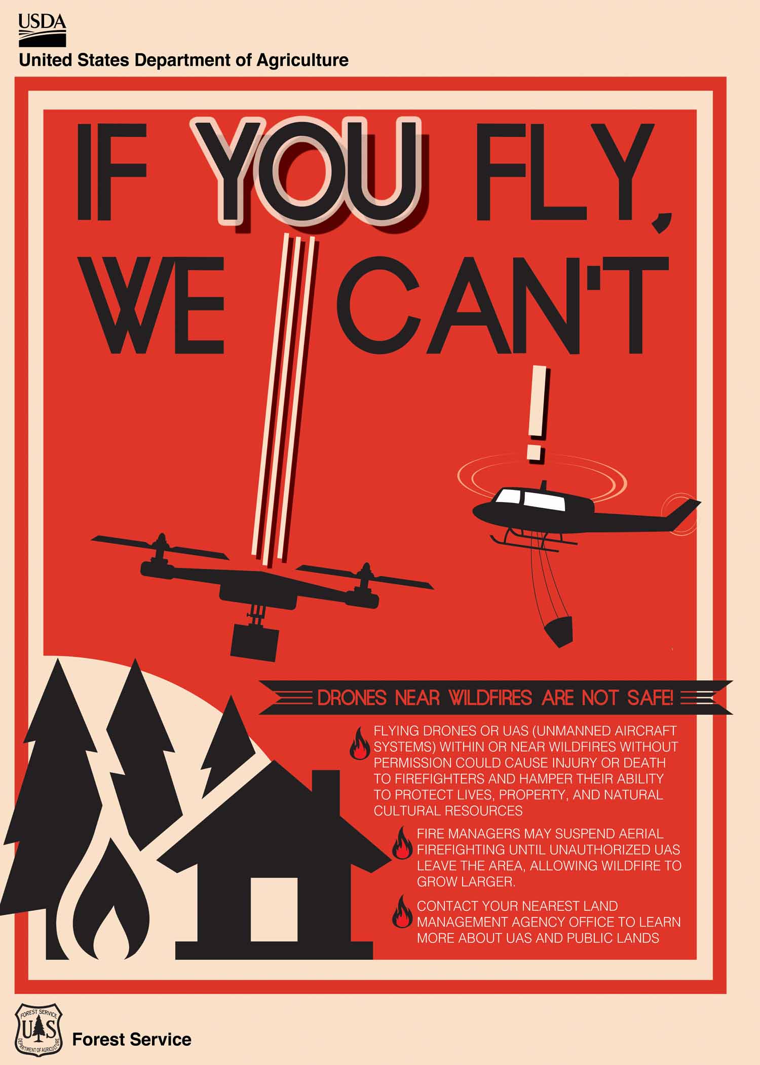
Unmanned Aerial Systems (UAS) or drones continue to be utilized for aerial reconnaissance for detecting hot spots. As a reminder to the public, the use of personal aircraft (UAS) or drones is restricted within the temporary flight restriction (TFR) airspace over the fire is prohibited. Any unidentified aircraft within the TFR that is detected will result in all aerial operations over the fire to cease and pose a safety hazard to aerial and ground personnel.
Closures and Restrictions: Access through Forest Service Road (FSR) 65 up through FSR 64 to the junction with Indian Camp is closed. Government Mountain Road/FSR 6511 is closed from North Fork Walla Walla trailhead to the junction with FSR 65 at Tiger Saddle. Government Mountain Rd/FSR 6511 is open from the west to North Fork Walla Walla trailhead. The current fire danger rating is MODERATE and public use restrictions phase A for Umatilla National Forest are in effect. For more information regarding restrictions, please contact Umatilla National Forest Toll-free Information Hotline: 1.877.958.9663.
Weather: Today, mostly clear with a few afternoon clouds and temperatures in the mid-60s to mid-70s. Winds are expected to be out of the west at 5-8 mph and gusting 10-15 mph along ridgetops. Relative humidities will drop down to 25-30 percent.
A warm and dry trend is expected for the next two days. Tuesday, a chance of rainfall is forecasted to begin later in the day and into the next several days as a cold front arrives Wednesday. Breezy conditions may exist with the frontal passage.
Smoke: Walla Walla’s air quality for today is good to moderate. Some residents along Mill Creek may experience smoke as the fire continues to burn. Check out https://wasmoke.blogspot.com/?m=1 for more information.
Rail Ridge Daily Update 10 14 2024
Related Incident:
Publication Type: Announcement
Rail Ridge Fire Update
October 14, 2024
Central Oregon Wildfire Information: centraloregonfire.org
Email: 2024.railridge@firenet.gov – Phone: 541-208-7111
Social Media, Evacuation and Closure Information: https://linktr.ee/RailRidgeFire
Acres: 174,936 – Containment: 89% – Detection: 09/02/24 – Cause: Lightning – Personnel: 602
Forest visitors near the Rail Ridge Fire should be aware that Forest and BLM closures as well as fire restrictions around the Rail Ridge Fire remain in place.
NWCIMT8 will be transitioning with NWCIMT2 over the next couple of days. Team 8 has appreciated the support of the local landowners, community and agency administrators during their two week assignment on the Rail Ridge Fire. Team 2 personnel will arrive today and will take command of the fire tomorrow evening.
Operational Update: Yesterday, some areas of the fire near Cougar Ridge were putting up significant smoke in the late afternoon, but there was minimal increase in growth. On the northwest corner of the fire, firefighters finished handline that connects the north side of the Black Canyon Wilderness to the Cougar Ridge edge of the fire perimeter. Heavy equipment and crews continue to construct containment line along the Forest Service Road 3850 on the northwest corner of the fire. Containment line through the BLM and private property is complete and firefighters are prepping the cabins with sprinkler kits and putting in hose lays. Fire personnel continued to patrol the contained perimeter of the fire, searching for hot spots or any increase in fire behavior. Resources were engaged on the Forest Service Road 24 and Forest Service Road 2150 to clear these roads of hazards.
Today, in the northwest corner of the fire expect to see increased smoke and fire behavior as we continue to see the drying trend over the fire area. Crews will continue with the same work from yesterday to create containment line around the active fire area around Cougar Ridge. The team’s meteorologist and fire behavior analyst are monitoring any change in weather, as there is currently a 70% chance of rain midway through the week. This is likely to push cold air in front of it that would result in increased winds on the fire, increasing fire activity. Air operations have three Type 1 helicopters and are using air attack to respond to the fire as needed. Fire crews are continuing mop-up and removal of hazards from across the fire footprint.
The fire team and local agencies continue to work with local landowners, businesses, and affiliates who need access within the fire area closures. Due to the multitude of hazards within the fire area, these requests are being prioritized and official escorts are being provided as safety and availability of escorts are feasible.
Weather: High pressure will be overhead through Tuesday and dry conditions are expected through this period with min RH percent dropping into the upper teens to low 20’s. Winds will be light and mostly terrain driven through Tuesday with gusts of 10 to 15 mph during the peak heating hours of the afternoon. The weather pattern will make a major change on Wednesday, with much cooler conditions and possibly some rainfall and gusty winds.
Forest & BLM Closures / Evacuation Information / Fire Restrictions for the Rail Ridge Fire area can be found at: https://linktr.ee/RailRidgeFire.
Logan Fire Daily Update 10 14 2024
Related Incident: Logan Fire
Publication Type: News
Logan Fire Statistics:
Size: 14,828 acres
Completion: 10%
Total Personnel: 273
Reported: 9/8/24
Cause: Lightning
Weather: Temperatures will remain in the mid 60’s. The stormfront is predicted to approach by midday on Wednesday and may produce a thunderstorm or two. By Thursday, snow is expected at the fire. The fire could receive around ¼-inch to a ½-inch of precipitation from this weather event.
Current Situation: Yesterday, the firefighters confirmed containment of a portion of the fire perimeter, resulting in the black lines you see on the map today. There was a little fire growth in Smith’s Creek, resulting in the increase in acres. The firefighters continued to add plumbing and sprinklers around the structures so they can protect the structures from approaching fire. The firefighters held the fire line at Big Creek Road and are prepping the road by removing vegetation south to Jacob’s Ladder Flat. Today, crews will work to get the Elk Creek Road passable and fall the hazard trees along the corridor. There is some heat in the Hogback ridge and firefighters are adding handline to the south and around Edwardsburg as contingency. Crews will be working along the Big Creek Road down to Jacob’s Ladder Flat and extinguish any remaining heat. There are snags along the road, which are hazard trees that are standing dead or fire-weakened trees, in the area. Firefighters will be watching for these and removing them as necessary. Firefighters will be on the Elk Summit Road to the Smith’s Creek Road as the fire is within ½-mile from one of the bridges on the Smith’s Creek side. Those bridges are being checked for options to limit the fire exposure to them.
Evacuations: Logan Fire Edwardsburg Area - The Valley County Sheriff’s Office has placed a "GO" evacuation notice for the Edwardsburg area due to the movement of the Logan Fire. Evacuation orders will be sent out via, CodeRED. Please download the mobile app and sign up. Information is available via the Valley County Idaho website at https://www.co.valley.id.us/WildfireEvacuation or the Valley County Sheriff’s Facebook page, https://www.facebook.com/profile.php?id=100064415776390
Closures: The Logan Fire has a closure around the fire on the Krassel Ranger District and the map and description are located at https://www.fs.usda.gov/alerts/payette/alerts-notices The Sheriff has closed the Warren-Profile Gap Road between Elk Summit and Profile Creek intersection just north of Yellow Pine (this is a County Road). The Big Creek Airstrip is closed.
Also, join members of the Great Basin Complex Incident Management Team and Payette National Forest agency officials for an informational meeting. The meeting will be held on Tuesday, October 15 at 12:00 P.M. at the Corner Pub in Yellow Pine, ID. Teams members and agency personnel will be available to answer questions and share updates.
Pack Trail Daily Update October 14 2024 10 14 2024
Related Incident:
Publication Type: News
Pack Trail Daily Update October 14, 2024
Total Acres: 77,559
Confined: 62%
Total Personnel: 639
Evacuations – Teton Country Emergency Management has announced that the Upper Gros Ventre area, east of Goosewing Ranch, will be placed under a Level 3 “GO” evacuation order at noon today.
Brooks Lake Lodge, Pinnacle Cabins, Falls Camp, and Long Creek have been reduced to a Level 2 “Set” Evacuation Warning. Level 3 “Go” evacuation orders remain in effect for Lava Mountain Lodge and McKenzie Highland Ranch. The Dunoir Road Corridor has been reduced to a Level 1 “Ready” Evacuation Warning. See the Fremont County Emergency Management Facebook Page for alerts and updates. See the Teton County Emergency Management website updates and to sign up for emergency alerts through Everbridge.
Operations – Today, warm, dry, and unstable conditions are expected to lead to increased fire activity. Yesterday, on the east side of the fire, ground crews conducted a firing operation west of Lava Mountain Lodge, taking advantage of favorable winds along 540 Road. On the south side, the Pack Trail Fire continued to move into areas around Cowboy Camp, Strawberry Warming Hut, and Fish Creek Guard Station. Fire behavior was spotted near the guard station, and firefighters used aircraft to suppress persistent activity while mopping up hotspots, patrolling, and refilling tanks for sprinkler systems set up for point protection. The fire remains confined north of Union Pass Road. On the west flank, firefighters are patrolling the Burnt Ridge area, using aircraft as the fire slowly creeps downhill. Structure protection crews continued wrapping buildings, laying hoses, and setting up sprinklers around any and all structures in the Gros Ventre valley. Overnight, on the south side, active fire behavior was observed near Buffalo Meadow, while on the west side, the fire showed moderate activity as it continued to creep downhill. Crews remain focused on patrolling for new smoke and fire growth.
Safety – Yesterday a Drone Incursion occurred over the fire area. Unauthorized flights within a temporary flight restriction are highly dangerous to firefighting aircraft and illegal. DO NOT fly drones in or around the fire airspace. Drivers on US-26 may experience periods of smoke today due to high winds. Please use caution while driving, use headlights, and expect to encounter fire vehicles along the road. If planning travel on US-26 across the Continental Divide monitor WY- DOT for possible closures due to fire activity.
Teton Interagency Fire managers are maintaining the Very High Fire Danger Rating for Grand Teton National Park, the Bridger-Teton National Forest, the Shoshone National Forest , and the National Elk Refuge. Due to excessively dry fuels, any spark can ignite fire which can spread rapidly, becoming a large fire and exhibit extreme fire intensity. Residents and visitors are urged to exercise extreme caution with fire or possible ignition sources.
Always build your campfires away from dry grass, leaves, and overhanging branches to reduce the risk of spreading wildfire. Clear at least a 10-foot perimeter around your fire, removing any flammable material, and make sure your fire is dead out and cool to touch before you go to sleep, or leave the area.
Weather – Today’s weather conditions present the potential for moderate fire behavior. The forecast calls for partly cloudy skies, with temperatures ranging from the low to mid-60s. Winds will come from the west/northwest at 10 MPH, with gusts reaching up to 16 MPH. Relative humidity will be between 19% and 24%. To learn more about air quality, visit Fire.AirNow.Gov.
Road Closures – The Union Pass Road is closed on the Pinedale District (BTNF) from Mosquito Lake to the DuNoir on the Wind River District (SHO).
Forest Closures - Closure Order #04-03-24-316 is in effect from October 9, 2024 at 12:00 p.m. through November 1, 2024 at 6:00 a.m. unless rescinded. This order supersedes previous orders, including #04-03-24-315, prohibiting the same or similar acts in the same described area.
For more information, visit: Facebook: USDA Forest Service - Bridger-Teton National Forest, USDA Forest Service - Shoshone National Forest Pack Trail Inciweb: https://inciweb.wildfire.gov/incident-information/wybtf-pack-trail-fire
###
Quick Facts Birch Fire October 14 10 14 2024
Related Incident:
Publication Type: News
October 13, 2024: Areas of increased fire activity was observed in the Mowitch Creek drainage. The inversion began lifting at approximately 3:00 pm which resulted in the increase in fire behavior. Firefighters observed fire in the East Fork of Indian Creek, fire remains on the west side of the drainage. There was a fair amount of smoke production in the Mowitch Creek drainage as fire continues to back down towards Indian Creek. Between the Mowitch Creek and Middle Fork of Indian Creek drainages, fire has reached the drainage bottom, showing isolated smoke. Burn period was approximately two (2) hours yesterday as smoke began to settle back in around 5:00 pm, limiting large fire growth.
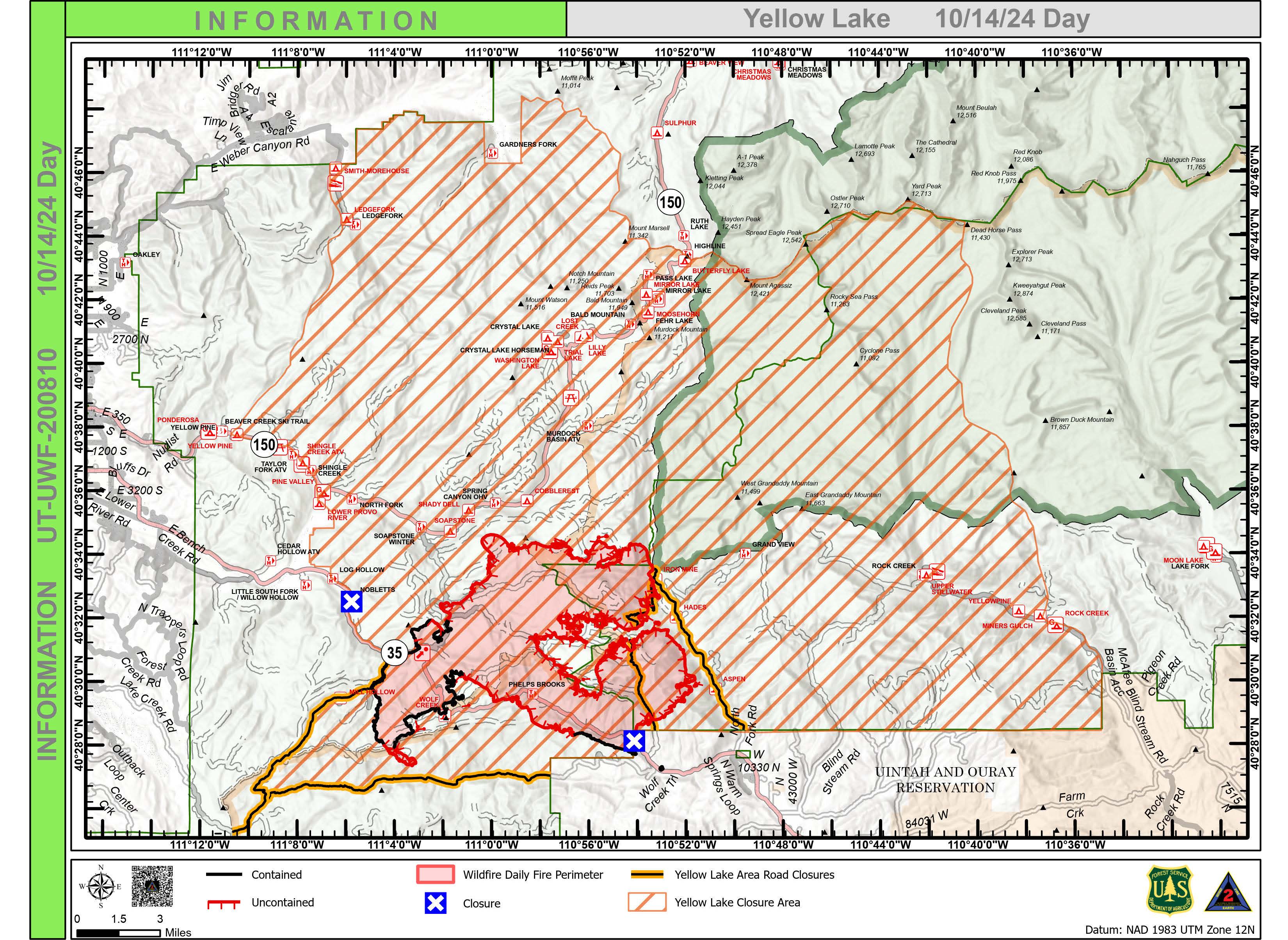
Yellow Lake Fire Update 10 14 2024
Related Incident: Yellow Lake Fire
Publication Type: News
Yellow Lake Fire
Incident Update October 14, 2024
Size at time of update: 31007
Containment: 23%
Personnel: 814
Start: Saturday, September 28, 2024
Cause: Undetermined
Location: 10 miles southeast of Francis, Utah
A public meeting will be held at 6 p.m. this evening at the Tabiona School gymnasium to update conditions on the Yellow Lake Fire. It will be live-streamed on the Uinta-Wasatch-Cache and Ashley National Forest Facebook pages.
On Sunday afternoon, weather conditions increased fire behavior near Iron Mine Road as winds from the South hit exposed areas of jackpot fuels comprised of concentrated beetle kill timber. The fire has not reached Iron Mine Road. Quarter-mile spotting was observed but, the Soapstone Summer Homes near Mirror Lake Highway were not impacted. Air operations were heavily deployed as the fire moved into stands of mixed conifer and dense aspen. Dozers continue to tie in fire line between Iron Mine Road and Soapstone Road.
Fire activity on the east side also increased, eventually shading itself out. Firefighters are observing the re-ignition of dead and down timber in what is known as “re-burn potential.” Moderate torching of snags is being observed nightly.
Above normal temperatures will continue through Wednesday, resulting in the further drying of fuels. A notable change in the weather is expected Thursday bringing freezing temperatures and a greater chance of precipitation.
Patrol and structure protection continue in the North Fork of the Duchesne. Fireline between Rhodes Canyon and Lightning Ridge are being reinforced.
All evacuation orders and closures remain in effect.
Forest Closures:
- Updated October 11, 2024, a closure has been increased on the Uinta-Wasatch-Cache National Forest due to the Yellow Lake Fire. This Order shall remain in effect until October 31, 2024, unless rescinded.
https://www.fs.usda.gov/Internet/FSE_DOCUMENTS/fseprd1208350.pdf - Updated October 11, 2024, a closure has been increased on the Ashley National Forest due to the Yellow Lake Fire. This closure will remain in place through December 31, 2024, or until rescinded, for public safety.
Evacuation Areas: The North and West Forks of the Duchesne River, and Granddaddy Lakes area are under a mandatory GO evacuation meaning all residents, hunters, and recreationists must leave and stay out of the area. Hanna is under a SET order, advising residents to have bags packed and be prepared to evacuate if necessary.
For updated evacuation zones, please visit:
https://emergency-management-operations-wasatch.hub.arcgis.com/
https://tricountyemergencyalert.genasys.com/portal/en
https://www.fs.usda.gov/Internet/FSE_DOCUMENTS/fseprd1208878.pdf
Bingham Fire Daily Update for Monday October 14 2024 10 14 2024
Related Incident: Bingham Fire
Publication Type: News
Crews prepare for wintery weather; incident command shifts to local forest
Daily Update: October 14, 2024
Fire Information Phone: 503-854-3366 (8 a.m.-8 p.m.)
Email: 2024.Bingham@firenet.gov
Acres: 199 Containment: 94%
Location: Areas of the Mount Jefferson Wilderness, east of Marion Forks.
Start Date: September 30,2024 Personnel: 131
Resources: 2 crews | 1 water tender | 1 falling module| 1 excavator
Highlights: Firefighters continue to seek out isolated hot spots that could pose a threat to the fire perimeter, repair damage to the landscape caused by suppression activities, and haul equipment out of the forest ahead of wintery weather forecast for Tuesday night.
The Bingham Fire remained at 199 acres today, with containment bumping up to 94 percent.
Crews will have mild weather on the fire line today and Tuesday, with temperatures in the upper 50s to lower 60s. However, by Tuesday evening an 80 percent chance of rain is forecast, and temperatures are expected to plummet. Temperatures will hover in the mid-30s to lower 40s Wednesday through Friday, with waves of precipitation passing through all three days, including a chance of 3 to 6 inches of snow.
Management of the fire will transition back to the Detroit Ranger District’s type 4 incident management team at 6 p.m. today from California Incident Management Team 1. This will be the last update issued from the Bingham Fire unless significant changes warrant otherwise. Additional fire information can be obtained by contacting the Willamette National Forest at 503-854-3366.
Evacuations: The Linn County Sheriff’s Office has reduced the size of LEVEL 3: GO NOW! evacuation areas Oct. 10, converting them to LEVEL 2: GET SET evacuation alerts. The Level 2 evacuation area extends along Highway 22 to a ½-mile west of Highway 22, from Pamelia Road (NFS Road 2246) south to Parrish Lake Road (NFS Road 2266). Please refer to the Linn County Wildfire Map for more information: https://tinyurl.com/LinnCoFireMap. Highway 22 remains open.
The Willamette National Forest also reduced its closure area Oct. 10 within the same footprint as the county’s Level 3 evacuation zone. Details of the closure order can be found here: https://tinyurl.com/2y4sacl8. The Pacific Crest Trail through the Mount Jefferson Wilderness remains open. Impacted trails include Bingham Ridge Trail, Independence Rock Trail, Marion Lake Trail and Lake of the Woods Trail. With hunting season started, Forest Service staff will work with the Linn County Sheriff’s Office to reduce closure areas as soon as it is safe to do so.
Weather: Mild temperatures in the upper 50s to lower 60s are expected today and Tuesday, with wetter and cooler weather ushering in Tuesday evening. Highs in the mid-30s to lower 40s are forecast Wednesday through Friday, with bouts of rain and snow falling sporadically during that time.
Railroad Daly Fire Update 10 14 2024
Related Incident:
Publication Type: News
Type 3 Incident Command Team, Incident Commander Matt Young
Location: Bitterroot NF: Railroad Creek/ Skalkaho Creek confluence, 26 miles southeast of Hamilton
Beaverhead-Deerlodge NF: 20 Miles northwest of Georgetown Lake Dam off Skalkaho Hwy 38
Start Date: 7/25/2024
Cause: Undetermined
Daly Fire Acres: 10,205 Railroad Fire Acres: 1,496 Completion: 56%
Total Personnel: 258
Current Status
An overnight infrared flight showed increased acres from days prior. Crews continued burn out operations to the southwest towards Skalkaho Hwy 38. Dozer and handline continued on the Gird/Skalkaho ridge. Firefighters continued firing off the dozer line creating a wide blackline in efforts to slow fires progression. Multiple helicopters aided firefighters during firing operations. Crews persisted with felling operations to remove hazardous trees along Skalkaho Hy 38.
Today crews will continue chipping along the coal creek road. They will also continue constructing a 100’ shaded fuel break extending from the Hwy 38 corridor to Stoney Creek drainage ridgeline.
On the west side of the fire, crews will hold previous firing operations in the Buckhorn Saddle area as well as cutting hazardous trees along Skalkaho Hwy 38.
Weather and Fire Behavior
Continued high pressure will bring warm and dry conditions with daily winds. Relative humidity recoveries will continue to be poor through Wednesday. Warm and dry conditions are forecasted Monday and Tuesday.
After Wednesday cooler temperature's are expected with periods of precipitation and snow levels lowering to 4,000 feet. There is a 50% Probability for at least 2” of snow over mountain passes by Friday morning.
EVACUATIONS
On October 9, 2024 the Ravalli County Sheriff’s Office issued an Evacuation Warning for residents off of Skalkaho Highway (1700-2500 block) due to the Railroad-Daly Fire. For more information on evacuations visit the Ravalli County Sheriff Facebook page.
To register your phone number for emergency notifications in Ravalli County visit, http://hyper-reach.com/mtravallisignup.html.
CLOSURES
For additional information on the Skalkaho Hwy 38 road closure visit Montana Department of Transportation.
The Beaverhead-Deerlodge National Forest has issued an Area/Road/Trail Closure effective October 4, 2024.
The Bitterroot National Forest has also issued a road closure effective October 10, 2024.
These order’s are for public and firefighter safety during fire suppression efforts on the Fire.
Closure information and maps are posted on the Bitterroot and Beaverhead-Deerlodge National Forests’ website www.fs.usda.gov/alerts/bdnf/alerts-notices and www.fs.usda.gov/alerts/bitterroot/alerts-notices.
Elkhorn Fire Update 10 14 2024
Related Incident: Elkhorn Fire
Publication Type: News
Elkhorn Fire Update: 10/14/2024
Today, containment of the Elkhorn Fire remains at 75%. Firefighters will continue to work on identifying and tending to interior hot spots and suppression repair work.
We are asking the public to help prevent new fire starts by observing and understanding the Dakota Prairie Grasslands Emergency Fire Closure and Restriction. The full Closure can be found at the following link: https://www.fs.usda.gov/alerts/dpg/alerts-notices/?aid=91474.
Logan Fire Informational Meeting Yellow Pine ID on Oct 15 at 1200 PM 10 14 2024
Related Incident: Logan Fire
Publication Type: Announcement
Join members of the Great Basin Complex Incident Management Team and Payette National Forest agency officials for an informational meeting. The meeting will be held on Tuesday, October 15 at 12:00 P.M. at the Corner Pub in Yellow Pine, ID. Teams members and agency personnel will be available to answer questions and share updates.