
Logan Fire Daily Update 10 16 2024
Related Incident: Logan Fire
Publication Type: News
Logan Fire Statistics:
Size: 15,836 acres
Completion: 10%
Total Personnel: 249
Weather: The high for today will be around 50-degrees with winds out of the southwest around 8-mph with gusts up to 15-20mph. A strong cold front will pass through the area with increasing cloud cover around noon and winds changing to northwest. Rain is expected on the fire this afternoon and overnight, with snow likely to develop tomorrow.
Current Situation: Yesterday, crews and helicopters used water to cool the fire and keep it away from the structures in the Logan Creek drainage when fire activity in the afternoon. Crews also worked to cool hot areas on the Hogback near the north end of the Big Creek Airstrip. A helicopter carried several loads of equipment from Monumental Airstrip back to the supply area in advance of the approaching storm. Crews wrapped bridges in the Smith Creek area and unwrapped Rabbit Lookout. Today, firefighters will continue to secure and strengthen their containment lines protecting Edwardsburg, and a large contingent will move out of the Big Creek area this afternoon before the storm hits. A hand crew, an engine crew, overhead and others will remain and continue to protect structures in the Edwardsburg and Big Creek Areas.
Evacuations: Logan Fire Edwardsburg Area - The Valley County Sheriff’s Office has placed a "GO" evacuation notice for the Edwardsburg area due to the movement of the Logan Fire. Evacuation orders will be sent out via, CodeRED. Please download the mobile app and sign up. Information is available via the Valley County Idaho website at https://www.co.valley.id.us/WildfireEvacuation or the Valley County Sheriff’s Facebook page, https://www.facebook.com/profile.php?id=100064415776390
Closures: The Logan Fire has a closure around the fire on the Krassel Ranger District and the map and description are located at https://www.fs.usda.gov/alerts/payette/alerts-notices The Sherrif has closed the Warren-Profile Gap Road between Elk Summit and Profile Creek intersection just north of Yellow Pine (this is a County Road). The Big Creek Airstrip is closed.
Elkhorn Fire Update 10 16 2024
Related Incident: Elkhorn Fire
Publication Type: News
Elkhorn Fire Update: 10/16/2024
Thanks to the successful work of all the firefighters who responded to the Elkhorn fire we can announce that the fire is 100% contained as of today.
While the fire is contained, that doesn’t mean that the work is done. Firefighters will continue doing suppression repair work through the coming days.
We would like to thank the Community of Watford City, including businesses and area residents for their heartfelt support throughout the incident.
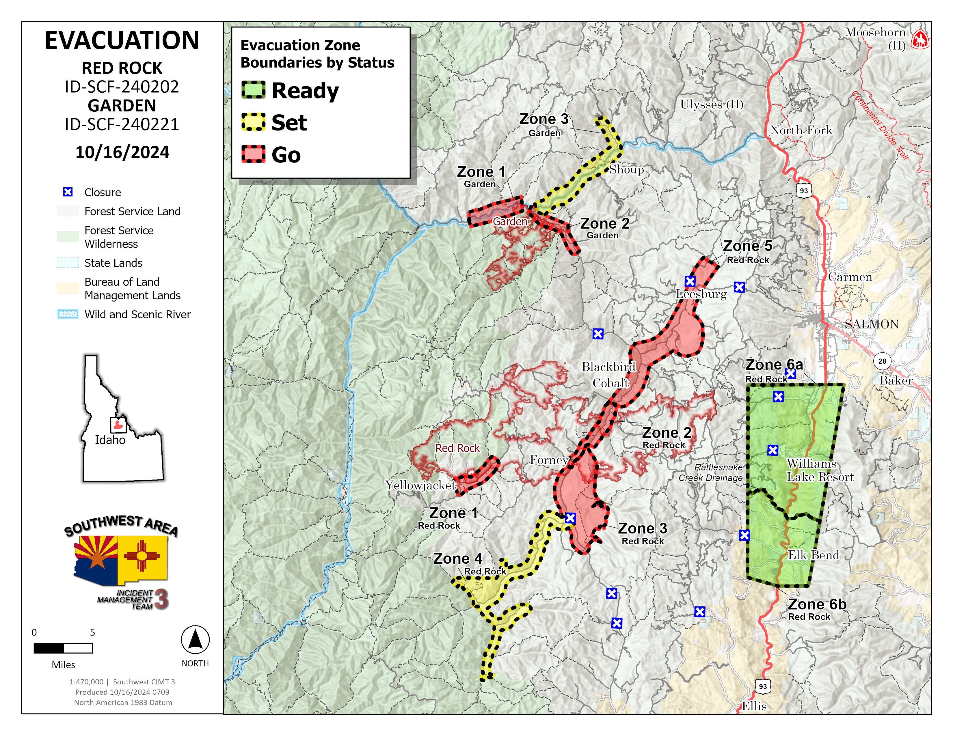
Garden and Red Rock Fires Update 10 16 2024
Related Incident:
Publication Type: News
Cold front likely to bring precipitation tonight
Red Rock Fire
Operations: Yesterday crews checked for hotspots along the handline built off Blackbird Road (FR 115) around the mine. In and around Cobalt, crews built line around some more structures near the Panther Creek Road (FR 055). Uncrewed aircraft applied fire to the interior of the perimeter on the northeast side to remove fuels ahead of the cold front which could bring increased winds. Across the rest of the east and south sides of the fire, heavy equipment and crews strengthened containment lines and mopped up the fire’s edge. Mop up continued on the spot fire in Napias Creek where downed trees have made the task challenging, but there are no concerns for fire growth.
Today, much of the focus will be on the Williams Creek Summit, down the Ridge Road toward Lake Mountain and the dozer line construction off Moyer Peak. With the passage of the cold front, higher west winds will try to push the fire towards the east, making the Ridge Road preparation the focus. Elsewhere across the fire crews are backhauling unnecessary pumps, hose and supplies and preparing other equipment for below freezing temperatures. Firefighters continue to look for and extinguish any remaining heat.
Garden Fire
Operations: Crews continued to monitor, mop up and secure lines particularly in Panther Creek and the Salmon River corridor. There are no additional ignitions planned at this time. Today crews will continue to make sure fire doesn’t spot across the river or move towards the west.
Additional Information
Weather: A vigorous cold front is forecast to travel across the Pacific Northwest on Wednesday. Skies will become mostly cloudy, allowing temperatures to be 5-10 degrees cooler than yesterday with highs in the mid-50s to lower 60s. The relative humidity will be around 10-15 percent higher and around 50 to 35% in the afternoon. Southwest winds will increase during the day with gusts to 20-25 mph along the higher ridges. Rain is forecast to spread across north central Idaho and will develop over Lemhi County in the afternoon. Cold air behind the front will lower snow levels to near 6000 feet Wednesday night down to 5000 feet on Thursday.
Smoke: Information about protecting your health from wildfire smoke is available. A smoke outlook is also available.
Closures: Salmon‐Challis National Forest has implemented a reduced Red Rock and Garden Fires Closure, Order Number: 04‐13‐24‐026. Please refer to the link below to see further information regarding the closure reduction.
Safety: A Temporary Flight Restriction (TFR) is in place over the Red Rock and Garden fire areas, which includes uncrewed aircraft systems or drones. Reminder that if you fly we can’t, unauthorized drone flights pose serious risks to firefighter and public safety and the effectiveness of wildfire suppression operations.
Please stay out of the fire area. There is still active fire behavior in the fire area, including group torching and crown runs. There are multiple roads and bridges that have been destroyed or are impassable. Entry into evacuation zones that are in “Go” status is prohibited. The updated forest closure notice that encompasses both the Red Rock Fire and Garden Fire areas includes multiple road and area closures. Barricade closures will be posted at road intersections and forest boundaries.
Evacuations: For evacuation information in Lemhi County regarding both the Red Rock and Garden fires please go to: https://www.lemhicountyidaho.org/emergency-management-department.
FOREST SERVICE BRIDGE POSTFIRE BAER ASSESSMENT TECHNICALWATERSHED RESPONSE REPORT RELEASED 10 23 2024
Related Incident: Southern California Post-Fire BAER 2024
Publication Type: News
FOREST SERVICE: BRIDGE POST-FIRE BAER ASSESSMENT TECHNICAL-WATERSHED RESPONSE REPORT RELEASED
The Forest Service—Angeles National Forest completed a Burned Area Emergency Response (BAER) post-fire assessment and technical watershed response report for the Bridge burned area and affected watersheds to determine their response, soil conditions, potential threats. The report summarizes the post-fire watershed assessment and expected response.
NOTE: Attached below as “Related Information” is a PDF documents called “BridgeBAER_PostFireTechnicalReport_10222024”.
BAER SAFETY MESSAGE: Everyone near and downstream from the burned areas should remain alert and stay updated on weather conditions that may result in heavy rains and increased water runoff. Flash flooding may occur quickly during heavy rain events--be prepared to act. Current weather and emergency notifications can be found at the National Weather Service website: www.weather.gov/lox/.
Park Fire Final Update 10 16 2024
Related Incident: Park Fire
Publication Type: News
SUSANVILLE, CA, October 16, 2024 — This will be the final update for the Park Fire. The Forest Service’s National Incident Management Organization Team 3 departed at the end of September, transferring incident management to the Lassen National Forest.
The Park Fire is now 100% contained and controlled. The Lassen National Forest continues to work to address threats to public safety resulting from the Park Fire. Through the next few months, the fire will remain in patrol status, resource protection and hazard tree mitigation work will be ongoing as well.
Over the last few months, the Lassen National Forest has completed various suppression repair activities, including hazard trees mitigation and removal, erosion control, watershed repairs, culvert repair and replacement, road blading and repair, and chipping of small materials to clear up woody debris.
There are multiple phases of post-fire actions after a wildfire, from suppression repair through long-term recovery. The Park Fire BAER Assessment Report Summary, completed on September 27, 2024, provided recommendations for the next steps in post fire recovery for your public lands. “As we work through these next phases, we look forward to working with our partners and communities to get the best results for these public lands we manage. Being a good steward is my primary focus as we tackle the difficult work ahead,” said Agency Administrator and Almanor District Ranger, Russell Nickerson.
Lassen National Forest lands, roads, and trails within the Park Fire Closure Area remain temporarily closed for the safety of the public and crews. Prior to recreating on your public lands, check Forest Order No. 06-24-07 and the closure map at fs.usda.gov/alerts/lassen/alerts-notices.
For more information about the Park Fire BAER Assessment visit https://inciweb.wildfire.gov/incident-information/calnf-park-postfire-baer. You can access the latest news and information about the Lassen National Forest at fs.usda.gov/lassen, or by following us on Facebook @LassenNationalForest or X @LassenNF.
###
USDA is an equal opportunity provider, employer and lender.
Quick Facts Birch Fire October 16 10 16 2024
Related Incident:
Publication Type: News
October 15: The fire was active as the inversion lifted around 1:00 pm. The fire continued to burn along the ridge between Mowitch Creek and East Fork Indian Creek, mostly burning in brush and heavies with some torching. Fire is now established on the slopes above Indian Creek, little progression in the direction of the mouth of Indian Creek. The fire has crossed over Indian Creek in the vicinity of Mowitch Creek and is burning in the low elevation timber. Fire is burning up drainage from the Middle Fork of Indian Creek and is held up in the rocky slopes.
Meridian Fire Update 10 15 2024
Related Incident: Meridian
Publication Type: News
Incident Commander: Jim King
Location: Meridian Creek. Approximately 40 miles south of Ennis, MT and approximately 10 miles southwest of
Lyons Bridge on HWY 287.
Start Date: 10/08/2024
Cause: Unknown
Size: Estimated at 2,797 acres as of 06:00 PM 10/15/2024
Resources on Site: 2-Type 1 helicopters, 1-20-person hand crew, 6-Type 6 engines.
Total Personnel: 54
The Meridian Fire was reported late in the day on October 8th and is located approximately 10 miles southwest of
Lyons Bridge on HWY 287 in the Meridian Creek Drainage. Fire managers from the Beaverhead-Deerlodge National
Forest have identified and prioritized critical values at risk in the fire area. Firefighting efforts will focus available
resources on the protection of structures that are currently in close proximity to the fires edge.
There are several factors involved in making wildfire management decisions. These factors include, firefighter
safety, resource availability and threats to public safety and property. As well as, terrain, fire behavior, fire season
outlook and modeling, and past prescribed fire units and vegetation management projects in the area. Fire
managers are strategic in their approach and continually reassess conditions and alter management strategies to
protect critical values.
CURRENT STATUS/PLANNED ACTIONS:
The fire increased by 1,372 acres today after it got established in timber across FS Trail 6019 and moved to the
east/northeast to the top of Cliff Lake Bench. Resources conducted a successful firing operation around structures
to reduce available fuel and increase depth between the fires edge and the structures. Two Type 1 helicopters
were used to drop water during the firing operation and provided aerial views and information of the fires spread.
The rest of the fire showed moderate fire activity throughout the day. Madison County Sheriff’s office spoke to
homeowners on Sundance Bench and Madison Valley Ranches and updated them on the fire situation. An
additional Type 1 helicopter was ordered and will be on scene for tomorrow’s shift.
“Do Not Report” signs remain in place at Raynolds Pass and the junction of HWY 87 and HWY 287 by Three Dollar
Bridge to minimize 911 calls impacting Madison County Dispatch. Information boards are still in place at the MT
DOT Rest Area at Lyons Bridge and Cliff/Wade Lake Campground. The smoke from this fire along with other fires
west of here will pool in low areas along the Madison and West Fork Madison tonight.
Barriers are in place at the junction of FS RD 209 and 1209 (West Fork and Jack Pine) to limit vehicle traffic to
Miller Flat and onto Cliff Lake Bench. Another barrier is in place at Cliff and Wade Lake Campground to limit traffic
into the campground. Additional barriers are in place at Hoodoo Pass and Miller Flat to reduce ATV/UTV traffic in
the fire area. Fire resources will be focused on protecting critical values at risk, scouting the fire, locating and
assessing values, finding viable features to reduce fire spread, and working available aircraft in areas where they
can be successful.
These actions are designed to allow fire personnel to protect the identified values at risk while operating in areas
that have much better access and egress to safety.
WEATHER AND FIRE BEHAVIOR:
The fire was very active from 02:00 PM until dark burning approximately 1,372 acres in those four hours. This was
the most activity witnessed on the fire since it started. It is expected to remain active tomorrow on the Cliff Lake
Bench, especially in patches of mature timber while the young lodgepole stands will have reduced fire behavior.
The west aspect between the West Fork Madison and Cliff Lake Bench had the most activity and will have active
fire behavior through the afternoon as well.
Tomorrow’s forecast will be similar to today’s weather until the evening where the next significant weather change
is forecasted. This will bring the potential for strong, gusty winds up to 35 mph during the day followed by a
chance of rain in the evening followed by rain and snow Thursday and Friday. After that it is forecasted to remain
cold with low temperatures in the teens and low 20s into 10/26.
CLOSURES AND RESTRICTIONS:
There are no fire restrictions on the Beaverhead-Deerlodge National Forest, or any area closures pertaining to the
Meridian Fire.
Rail Ridge Daily Update 10 15 2024
Related Incident:
Publication Type: News
Rail Ridge Fire Update
October 15, 2024
Central Oregon Wildfire Information: centraloregonfire.org
Email: 2024.railridge@firenet.gov – Phone: 541-208-7111
Social Media, Evacuation and Closure Information: https://linktr.ee/RailRidgeFire
Acres: 175,060 – Containment: 89% – Detection: 09/02/24 – Cause: Lightning – Personnel: 609
Forest visitors near the Rail Ridge Fire should be aware that Forest and BLM closures as well as fire restrictions around the Rail Ridge Fire remain in place.
NWCIMT8 will be transitioning with NWCIMT2 today at 8pm. Team 8 has appreciated the support of the local landowners, community and agency administrators during their two week assignment on the Rail Ridge Fire. Team 2 personnel arrived yesterday to begin the transition process.
Operational Update: Yesterday, winds and dry conditions caused the fire near Cougar Ridge to increase in activity, causing significant increase of smoke throughout the day. Strong winds with gusts up to 20mph were flowing from the southwest, before shifting from the northwest in the late afternoon. Cloud coverage over the area shaded the fire until about noon, causing temperatures to increase, humidity to drop, and overall fire activity to increase in the northwest. An IR flight over night shows the fire increased by 900 acres. Air resources included four Type 1 helicopters, three air tankers, and an air attack. These resources were utilized to protect the values at risk north of Cougar Ridge where an increase of fire activity was observed by dropping water buckets and retardant. Heavy machinery and crews continued to establish containment line on the northwest section of the fire. Crews continued to patrol the contained perimeter of the fire to locate hot spots, remove debris, and take down hazard trees. While some crews have been moved to the northwest of the fire to assist in containment, fire personnel continued to diligently work on repairing roads throughout the burn area, including FS Road 2150 and 24.
Today, expect to see similar fire activity as yesterday. Fire behavior is expected to increase once the smoke inversion lifts early in the day. Winds will flow in from the southwest in the morning and shift to come from the northwest by this evening. Firefighters are expecting to see an increase of torching and spotting in the heat of the day in the northwest. A change of weather, meteorologists are expecting a 70% chance of wetting rain tonight after midnight. In the highest elevations, this precipitation may appear as snow! Heavy machinery is still being used on the northwest perimeter to establish containment line along FS Road 3850. Fire managers are evaluating the terrain and infrastructure north of the containment lines on the active piece of the fire to install contingency lines. Crews will continue mop and suppression repair along contained edges of the fire. Air resources will continue to be used as needed.
Weather: High pressure will push east later today as low pressure pushed in from the west. Expect increasing clouds by later this afternoon through this evening and a chance of rain after midnight. There will be a few hours of dry conditions this afternoon with min RH down to 25%, and then quickly rise this evening. Winds will be out of the southwest this afternoon and turn west-northwest this evening and tonight with gusts of 12-15 mph. Temperatures will likely dip below freezing Wednesday night into Thursday and light snow will be possible above 4,500 ft elevation.
Forest & BLM Closures / Evacuation Information / Fire Restrictions for the Rail Ridge Fire area can be found at: https://linktr.ee/RailRidgeFire.
Nevada Lake Fire Update 10 15 2024
Related Incident:
Publication Type: Announcement
Location: 8 miles east of Helmville, MT, 0.5 miles north of Nevada Lake
Start Date: 10/14/2024
Cause: Escaped Prescribed Burn
Size: 207 acres
Containment: 0%
CURRENT STATUS
The Nevada Lake Fire is currently 207 acres and actively burning in open grass and heavy timber on the Fish, Wildlife and Parks (FWP) Nevada Lake Wildlife Management Area (WMA) and private land east of Helmville, Montana. Current resources on scene include 11 engines, two dozers, two skidgines, one excavator, and two Type 2 helicopters plus helitack personnel. A Type 3 Incident Commander is enroute, as well as additional helicopters and a Type 2 hand crew.
The wildfire is the result of a FWP escaped prescribed burn ignited on Monday, October 14, north of Nevada Lake on the WMA. The burn was declared a wildfire at approximately 4 p.m. when attempts to control areas where the prescribed fire escaped containment lines were unsuccessful. The DNRC is managing the wildfire response. Initial response efforts to the wildfire included 12 local government engines from four fire departments, four DNRC engines, and one USFS engine. A Very Large Air Tanker (VLAT) dropped two loads of retardant to help slow its progress.
Today, firefighters will focus on protecting values at risk and halting the fire’s forward progress. Ground crews will work on establishing and securing containment lines around the fire’s perimeter, while helicopters drop water on hot spots.
WEATHER AND FIRE BEHAVIOR
Today will be warm and dry ahead of a cold front passing through Wednesday. The front will bring a chance of wetting rains but also an increase in southwest to westerly winds, which could elevate fire behavior. Cooler and showery conditions will continue Thursday, with a chance of snow at 4000 feet.
EVACUATIONS AND CLOSURES
There are no evacuations or closures at this time, but the public is asked to avoid the area. Area residents should be vigilant and remain prepared. For updates, visit https://inciweb.wildfire.gov/incident-information/mtmts-nevada-lake-fireand monitor the Powell County Sheriff's Office Facebook page.
For tips on being prepared for wildfire, please visit https://www.mtfireinfo.org/pages/preparedness.
Shoe Fire Daily Update for 10 15 2024
Related Incident: Shoe Fire
Publication Type: News
Fire Information: 530-338-0317
Media Line: 909-855-4233
Hours: 08:00am to 7:00pm
Location: Shasta County, CA Start Date: Wednesday, October 9, 2024, at 6:57 p.m.
Cause: Human caused Size: 3,559 acres
Percent Contained: 7% Vegetation: Timber, Chapparal
Number of Personnel Assigned: 786
As of October 15, 2024, the Shoe Fire has burned 3,559 acres and remains at 7% containment. Last night, fire activity continued to increase in the South and East sides.
With a forecasted wind event approaching, our team has continued to bring in additional resources in preparation of expected fire growth due to the alignment of topography and weather. Strong winds and steep terrain alignment pose a risk for increased fire activity. Ground crews are working diligently to reinforce control lines along the fires edge utilizing a variety of heavy equipment, aircraft, hand crews, engines and hotshot crews. Additionally, Hirz Bay campground is currently closed to the public and is being used as a base camp for our crews.
Fire weather watch in effect from Thursday through Saturday evening for gusty north to east wind and low humidity. A Pacific storm moves through tonight into Wednesday bringing cooling with increased onshore flow and some precipitation. Gusty and drying northerly wind develops Thursday night into Saturday leading to critical weather conditions.
Mandatory evacuations remain in place for zone LKH-1448-B. Residents who have not evacuated are encouraged to do so. Evacuation information and alerts can be found by visiting protect.genasys.com
Information staff for the Shoe Fire are working diligently to provide timely and accurate information to the public. Fire updates can be found on the Shoe Fire 2024 Facebook page: www.facebook.com/2024ShoeFire/
Additionally, the Shoe fire was named after Shoeinhorse Mountain which is in close proximity to this incident.
WEATHER: The forecast for the area indicates a warming trend over the next few days with increased winds.
EVACUATIONS: Zone LKH-1448-B
ROAD CLOSURES:
- Fenders Ferry Road at Pit River 7 Bridge: West-Bound Fenders Ferry Road (Also known as 34N17 - Forest Service Road 27) at the Pit River Bridge/Pit 7
- Ferry Road is closed at McCloud Bridge: East-Bound Fenders Ferry Road at the McCloud River Bridge
![]() @ShastaTrinityNF
@ShastaTrinityNF ![]() @ shastatrinitynf
@ shastatrinitynf
Email: 2024.shoe@firenet.gov
Incident Website: https://inciweb.wildfire.gov/incident-information/cashf-shoe-fire
Forest Website: https://www.fs.usda.gov/stnf
Fire Weather Forecast: https://www.weather.gov/wrh/CAFW?area=ECC005
Last night, during the evening shift on October 13, activity continues to increase in the Beartrap area.
Additional resources have arrived and been put into place to bolster existing equipment and personnel. Fire fighters have reported successful firing operations along with the utilization of dozer lines in the north and west sides of the fire to create containment lines. The south and east sides of the fire, primarily in the Beartrap creek continue to have an increase in fire behavior. Dozers have had some limited capabilities due to road access. Aircraft and dozer operations will remain a key priority to create access to the south and east sides of the fire. Dozers continue to work to gain better access for direct fire line attack. The safety of our firefighters is priority and they will continue to make progress in a safe manner.
Fire is progressing northward fueled by down slope and down valley winds. Constant changes in wind direction will be observed today along with wind gusts, gusting between 10 to 15 miles per hour.
Mandatory evacuations remain in place for zone LKH-1448-B. Residents who have not evacuated are encouraged to do so. Evacuation information and alerts can be found by visiting protect.genasys.com
Information staff for the Shoe Fire are working diligently to provide timely and accurate information to the public. Fire updates can be found on the Shoe Fire 2024 Facebook page: www.facebook.com/2024ShoeFire/
Additionally, the Shoe fire was named after Shoeinhorse Mountain which is in close proximity to this incident.
WEATHER: The forecast for the area indicates a warming trend over the next few days with increased winds.
EVACUATIONS: Zone LKH-1448-B
ROAD CLOSURES:
- Fenders Ferry Road at Pit River 7 Bridge: West-Bound Fenders Ferry Road (Also known as 34N17 - Forest Service Road 27) at the Pit River Bridge/Pit 7
- Ferry Road is closed at McCloud Bridge: East-Bound Fenders Ferry Road at the McCloud River Bridge