
Settings - change map background and toggle additional layers
Filter - control incident types displayed on map.
Zoom to your location
Reset map zoom and position
Could not determine your location.
Show Legend
 Wildfire
 Prescribed Fire
 Burned Area
Response
Burned Area
Response Other
Other
Salmon Fire
Unit Information
Incident Contacts
Flat Fire Update 08082023
Related Incident: Flat Fire
Publication Type: News
August 8, 2023
Flat Fire Morning Update
Size: 33,291 acres Start Date: July 15, 2023
Point of origin: 2 miles southeast of Agness, OR
Containment: 39%
Total personnel: 792
Resources: 20 engines l 21 crews l 3 bulldozers l 27 water tenders l 4 masticators l 7 helicopters
Highlights: Helicopters conducted water and retardant drops yesterday to cool a small hotspot 400 feet inside the line and to limit the potential for fire growth in the Indigo Creek area of the fire. Smaller fuels are burning, but bigger fuels are still slow to ignite, which limits the ability of the fire to spread. Today will be a little warmer before temperatures drop a few degrees and slightly higher humidity will move in, further hindering the the ability of the fire to spread. Firefighters remain ready for any potential changes in fire activity.
Today’s Activities: Water and retardant drops may be utilized again today, dependent on fire behavior, in the Indigo Creek and Game Lake areas. Resource specialists are consulting with fire personnel to ensure retardant is used in ridgetop locations that will not impact rivers and the salmon in them. Stabilization crews and equipment have arrived to begin work in areas impacted by the fire and suppression efforts. These crews will begin installations of waterbars and other water mitigation activities to prepare the impacted areas for future rain events while maintaining the integrity of the existing lines. Fire crews continue to secure and improve existing and alternate containment lines. Structural protection and night-shift resources remain in place around Agness. Firefighters remain ready to respond to any changes in fire behavior.
With increased fire traffic, all motorists are asked to use caution - slow down and use headlights, especially on Bear Camp Road.
Weather: Temperatures will be warmer by 2 to 5 degrees and humidity will drop by 3% to 5%. Winds will continue to be terrain driven with northeast winds in the morning and northwest winds in the afternoon. Peak wind gusts are expected in the morning hours on the ridges and in the valleys in the afternoon.
Smoke: Smoke may be visible from the surrounding areas. The Smoke Outlook is available at: https://outlooks.wildlandfiresmoke.net/outlook/b74901f7?
Closures: The Rogue River-Siskiyou National Forest (RRSNF) has issued a closure order for the fire area including trails, roads and a portion of the Illinois River. Oak Flat Campground, Game Lake and Wild Horse Campgrounds and Snow Camp Lookout Recreation Rentals are all closed. The Chetco River Road (FSR 1376) and Chetco/Pistol River Road (FSR 1407) are closed. The closure allows for public access to the Big Rock swimming hole on the Illinois River.
Evacuations: Level 1 “Get Ready” evacuation status in place for areas in the vicinity of the Flat Fire. Link to more information: https://tinyurl.com/currycountyem
Restrictions: Fire danger is currently extreme; the RRSNF is implementing Level 2 Public Use Restrictions. More information here: https://tinyurl.com/ueuznr6e
Please follow all fire restrictions to prevent wildfires. Know before you go. Check on whether there are any campfire restrictions at your recreation destination.
Fire Information:(541)216-4579 Media inquiries: (541)237-6369 Email: 2023.flat.or@firenet.gov
Facebook: facebook.com/flatfireoregon2023 Twitter: twitter.com/FlatFireOR2023 Inciweb: bit.ly/FlatFireOR
Ridge Fire Daily Update August 8
Related Incident:
Publication Type: News
NORTHERN ROCKIES TEAM 9 INCIDENT COMMANDER: SHANE MARTIN
Ridge Fire
Flathead National Forest, Hungry Horse Ranger District
Fire Information 406-998-6074 2023.ridge@firenet.gov
inciweb.nwcg.gov/incident-information/mtfnf-ridge-fire
August 8, 2023
Location: 6 miles southeast of Hungry Horse, MT
Start Date: 7/30/23 Cause: Lightning Size: 2,940 acres Containment: 0%.
Total Personnel: 198 Engines: 5 Dozers: 3 Hand Crews: 5 Water Tenders: 6
KEY MESSAGE
Hungry Horse Reservoir is CLOSED effective August 8th, 2023. To provide for public and firefighter safety, FS Road #38 (East Side Road #38) is closed to all public traffic east of the junction of FS Road #497 (Desert Mountain Road) and East Side Road #38. West Side South Fork Road #895 will be closed starting from the Hungry Horse Dam Visitor Center. The road will remain open approximately 800 feet south of the west abutment of Hungry Horse Dam to facilitate traffic flow. Pre-evacuation notice in effect for private property along SF Abbot Creek on the west side of the fire.
CURRENT SITUATION
Current acreage is at 2,940 acres, an increase of 167 acres. Indirect (away from the fire) suppression efforts are being prioritized on the west side of the fire to protect critical infrastructure and private property. This is a full suppression fire, but options to engage the fire directly are limited due to heavy fuel (vegetation) and steep terrain. Firefighter and public safety is the top priority.
Yesterday, heavy equipment continued constructing the fuel break on the west side of the fire along the Hard Money Road between private property and Forest Service land. Hand crews completed the fuel break along the East Side Road #38, from the junction of East Side Road #38 and Desert Mountain Road to the Emery Creek drainage. Structure protection assessments and coordination were conducted for private property in Coram, Martin City, and Hungry Horse.
Today, heavy equipment, including masticators, dozers, and skidders, will continue implementing the fuel break near the Hard Money Road working north towards Highway 2. This fuel break is used to decrease fire intensity to private property if it were to reach this area and provide suppression options. Two Interagency hotshot crews arrived today. These crews, along with a dozer, will be opening up existing roads near the East Side Road to check the fire’s spread. Structure protection assessments and coordination will continue for private property in Martin City, Coram and Hungry Horse.
WEATHER AND FIRE BEHAVIOR
Showers and thunderstorms possible in afternoons through Wednesday with increased humidities. No wetting rain is expected. Fire activity has been low the past few days on all sides of the fire and is expected to remain low today. The fire is burning in heavy fuels and steep terrain.
CLOSURES AND SPECIAL MESSAGES
A Complex Incident Management Team is assuming command of the fire tomorrow. Residents should stay alert for changing conditions and visit ready.gov/wildfires for preparing for wildfires. For up-to-date information on the Ridge Fire, please visit Inciweb, Flathead National Forest Facebook, and Flathead County Sherriff’s Office Facebook for evacuation information.
Tin Soldier Complex Daily Update August 8th 2023
Related Incident:
Publication Type: News
SUMMARY
The Tin Soldier Complex is estimated at 2,631 acres in size and remains 0% contained. Fire activity Monday was minimal between the 3 fires. An IR flight detected an increase of 51 acres of growth across all three fires with Kah Mountain and Sullivan being the most active.
Current Acres burned as of the morning of Tuesday, August 8th.
- Bruce Fire – 993 acres at 0% containment
- Kah Mtn Fire – 407 acres at 0% containment
- Sullivan Fire – 1,208 acres at 0% containment
- Con Kelly Fire – 0.25 acres – Out.
The Bruce, Kah and Sullivan fires are being managed with point source protection to protect values at risk. Values at risk include Stony Communications Site, hydro-electric plant, Heinrude residential community, commercial guest ranches and the Spotted Bear Ranger Station compound.
PLANNED ACTIONS
Fire personnel continue structure protection efforts for the Spotted Bear Ranch, Diamond R Ranch and the Spotted Bear Ranger Station compound. Fire personnel have developed a structure plan for the Heinrude residential community. The plan for today will focus on reducing fuels with mechanical equipment on the south end and reestablishing fuel breaks on the north end in the area around the community.
EVACUATIONS, CLOSURES AND RESTRICTIONS
Evacuation: An evacuation has been issued by the Flathead County Sheriff for Heinrude community.
Restrictions/Closures:
- Stage 2 fire restrictions are in effect as of August 5th.
- An area closure is in effect for the Hungry Horse Reservoir, the front country of the Spotted Bear district as well the Gorge Creek drainage within the Bob Marshall Wilderness area, including Feather, Inspiration, Gorge, Canyon Trickle, and Stadium Creeks.
- A Temporary Flight Restriction is in place for air space over the Tin Soldier Complex to provide a safe environment for firefighting aircraft operating in the area. This includes the Spotted Bear and Meadow Creek Airstrips! Remember that temporary flight restrictions also apply to UAS or drones. If you fly, we can’t!
WEATHER
Forecasted temperatures starting today through the end of the week are expected to be in the mid to upper 80’s with relative humidities below 25%. Westerly winds up to 40 mph on the ridgetops are likely starting Wednesday through Thursday which may lead to increases in fire behavior and growth. This incoming warm weather with possible gusty winds will increase the chances of larger fuels burning (between 3 inches and 8 inches in diameter) as the dryness of these fuels remain near record lows.
Kane Fire Daily Update Tuesday August 8
Related Incident: Kane Fire
Publication Type: News
Southwest Area Type 2 Incident Management Team 4 assumes command of lightning-caused Kane Fire
August 8, 2023 – Daily Update
Acres: 3,247 acres
Start Date: August 4, 2023
Cause: Lightning
Containment: 0%
Total personnel: 165
Location: 11 miles south of US 89A, near Forest Road 220, North Kaibab Ranger District, AZ
Fuels: Pinyon pine/juniper with grasses and sage
Highlights: The Southwest Area Type 2 Incident Management Team 4, led by Incident Commander Aaron Hulburd, assumed command of the Kane Fire at 6:00 AM this morning, Tuesday, August 8, 2023. The Type 2 Incident Management Team brings additional resources and management capabilities to implement a full suppression strategy for the Kane Fire. The Kane Fire was first detected on August 4, following a lightning storm on the evening of August 3.
Operations: As additional resources arrive, fire managers will develop strategies to fully contain the fire while protecting valuable resources in the area, including natural and cultural resources, and private property east of the fire. Firefighters are planning to install sprinkler systems around the historic structures at Kane Ranch to increase protections as southwest winds push the fire toward the east. Fire managers estimate the fire grew approximately 50 acres yesterday; however, the total acreage decreased from the previous day due to more accurate mapping of the incident. Fire crews are scouting State Route 89A as a potential feature to prevent any future fire spread to the north. Because the eastern portion of the Kaibab Plateau is in a rain shadow, fuels are drier than normal and more receptive to ignition, particularly during high wind events at the hottest time of the day.
Weather: A Red Flag Warning has been issued over the Kane Fire area today, bringing increasing southwest winds and only a slight chance of rain. Any storm that does form could bring strong gusty outflow winds that could influence fire spread. These southwest winds will likely continue through much of tonight. Deeper moisture will arrive during the day on Wednesday with a better chance of precipitation. Deep moisture will remain over the area through at least Thursday.
Closures: In the coming days, the Kaibab National Forest plans to issue a temporary safety closure for the Kane Fire area, including affected roads and trails. The purpose of the closure order will be to protect public health and safety during the Kane Fire, and to protect assigned firefighting personnel engaging in wildland firefighting operations. The full closure order and map will be posted on the Kaibab National Forest website at https://www.fs.usda.gov/alerts/kaibab/alerts-notices.
Safety: The health and safety of firefighters and the public are always the first priority. Members of the public should stay away from Kane Fire operations. A temporary flight restriction (TFR) is in place over the area, which includes unmanned aircraft, or drones. More information on the dangers drones pose to wildland firefighting aircraft and personnel on the ground can be found at: https://uas.nifc.gov/.
Smoke: Smoke from the Kane Fire may be visible in the surrounding areas of Page, Tuba City, Tusayan, Flagstaff, and Fredonia, AZ. Although smoke is visible from many areas south of the Grand Canyon, it is generally spreading to the northeast. Smoke-sensitive individuals and people with respiratory problems or heart disease are encouraged to take precautionary measures. An interactive smoke map at https://fire.airnow.gov/ allows you to zoom into your area to see the latest smoke conditions.
Fire updates are posted on InciWeb and the Kaibab NF website, Facebook, and Twitter pages
Email: 2023.kane@firenet.gov • Phone: (928) 421-4983 • Office Hours: 8:00 AM – 8:00 PM
Actualizacin del Incendio Lowline Martes 8 de Agosto 2023
Related Incident: Lowline Fire
Publication Type: News
Actualización del Incendio Lowline
Martes 8 de Agosto, 2023 – 9:00 a.m.
Equipo de Gestión de Incidentes del Complejo del área de las Montañas Rocosas 1
Dan Dallas, Comandante del Incidente
Teléfono de Información: 970-648-4470 (publico), 970-765-7123 (medios de comunicación)
Correo electrónico: 2023.lowline@firenet.gov
Horario: 8 a.m. – 8 p.m.
Nota Especial: Hoy será el último turno del Equipo de Manejo de Incidentes del Complejo Rocky Mountain, dirigido por el Comandante de Incidentes Dan Dallas. El mando del incendio Lowline se transferirá a un Equipo de gestión de incidentes Tipo 3 dirigido por el Comandante de incidentes Bryan Gaines a las 6:00 a. m. del miércoles. El personal del Equipo Tipo 3 están actualmente siguiendo a sus contrapartes en el Equipo de las Montañas Rocosas para implementar una transición sin problemas.
Situación Actual: Ayer, no se produjo ningún crecimiento del perímetro y las líneas de fuego resistieron el crecimiento del fuego. Los bomberos estaban preparados para un comportamiento severo del fuego debido a las condiciones de Bandera Roja. Se realizaron lanzamientos de agua desde helicópteros para enfriar la intensidad del fuego en el interior y reducir las manchas sobre las líneas de fuego. Las tripulaciones preparadas previamente también se trasladaron para aumentar la capacidad en la División A/Z.
Hoy será el tercer día de condiciones de Bandera Roja, lo que demuestra aún más la fortaleza de la línea. Las acciones previstas siguen siendo las mismas de ayer con bomberos ubicados en el perímetro con buena visibilidad y posición para responder al movimiento del fuego. A medida que se intensifica el comportamiento del fuego, los bomberos pueden utilizar el helicóptero para arrojar agua, reposicionar recursos e implementar otros elementos de los planes preestablecidos según sea necesario.
División A/Z: Se observó un comportamiento intenso del fuego a medida que el fuego consumía más combustibles en las islas interiores. Se necesitaron varios lanzamientos de agua desde un helicóptero a lo largo del día para reducir la intensidad del fuego y disminuir la posibilidad de que las brasas viajaran fuera de las líneas de contención. Se produjo un pequeño foco secundario y los bomberos lo extinguieron rápidamente. La capacidad de extinción de incendios se reforzó con equipos de otras divisiones que ayudaron a patrullar la actividad de incendios. El plan de hoy es el mismo que el de ayer, ya que se espera una mayor actividad de incendios nuevamente.
División Y: A medida que los bomberos observaron el aumento de la actividad del fuego entre las líneas de fuego directas e indirectas, los helicópteros ayudaron a enfriar el fuego arrojando agua. No se necesitaron acciones adicionales y se reubicaron varias tripulaciones para brindar apoyo adicional en la División A/Z. El mismo enfoque está previsto para hoy.
División X: Los jefes de bomberos han implementado una estrategia de confinamiento en la división. Las barreras naturales y las características topográficas ayudarán a mantener el perímetro confinado a una huella aceptable. Ayer no hubo un crecimiento significativo.
División W: Los bomberos patrullaron en busca de actividad de fuego mientras quemaba combustibles cerca del borde norte y retrocedía hacia Middle Creek. Varias tripulaciones fueron reubicadas en la División A/Z para brindar asistencia adicional. Las tácticas permanecen sin cambios hoy.
Protección de Estructuras: Los equipos de protección de estructuras permanecieron atentos y muy cerca de las estructuras cerca del lado este del incendio y tomarán las mismas medidas nuevamente hoy.
Condiciones Climáticas y de Combustibles:
Después de dos días de condiciones ventosas, temperaturas cálidas, humedad en la adolescencia y mala recuperación durante la noche, la actividad del fuego en el interior volverá a ser muy activa y se verá similar a ayer. Bajo la Advertencia de Bandera Roja sobre el área del incendio, las temperaturas estarán en los 70 grados superiores con humedad en el rango del 15% y ráfagas de viento de hasta 35 mph.
Evacuaciones, Cierres, y Restricciones de Incendios:
Hay una orden de evacuación previa vigente para CR 727, Mill Creek. No hay otras evacuaciones o evacuaciones previas cerca del incendio. Para obtener información sobre la evacuación, consulte Manejo de emergencias del condado de Gunnison en www.gunnisoncounty.org. Puede registrarse para recibir alertas de emergencia en sus teléfonos u otros dispositivos en: https://bit.ly/3QhZVZg.
Cierres del Sistema Forestal Nacional: https://www.fs.usda.gov/Internet/FSE_DOCUMENTS/fseprd1126172.pdf.
Cierres temporarios del BLM: https://tinyurl.com/5n8s7xee.
Restricciones de Incendios en el condado de Gunnison: ninguno.
Reportes sobre la perspectiva de humo: https://outlooks.airfire.org/outlook/ed63b240.
Los incendios forestales son una zona de exclusión aérea para aeronaves no autorizadas, incluidos los drones. Si tu vuelas, nosotros no podemos. Para obtener más información, visite http://knowbeforeyoufly.org.
![]()
![]()
Midnight Fire Update August 8 2023
Related Incident:
Publication Type: News
Location: Forest Service Road (FSR) #284 (Elk City Wagon Road) 1 mile east of China Point, 3 miles Northwest of Pilot Knob near Mountain House Site
Start Date: 7/10/23 Cause: Lightning Size: 179 acres Completion/Containment: 50%
Total Personnel: 96 Engines: 2 Dozers: 2 Masticators: 2 Helicopters: 0
Water Tender: 2 Crews: 1
*Some forest resources are not counted in total personnel.
CURRENT SITUATION
No new fire growth has occurred, and containment of the Midnight Fire remains at 50%. Fire managers and personnel continue to patrol the area as periodic lightning has occurred over the past few days. The team is dissembling the Incident Command Post as resources continue to depart.
*This will be the final daily update unless the situation changes. For current information, please go to Inciweb at: www.inciweb.nwcg.gov
PLANNED ACTIONS
The Wyoming Type 3 team is transitioning with a local Type 4 IC Wednesday August 9th. Fire managers will continue to take appropriate action based on a variety of factors including complexity, fire behavior and weather, safety remains the number one priority. Contingency line work will continue, but due to rain on recent burn scars, crews will also clean fallen rocks, downed trees and keep the roads assessable for safety.
WEATHER AND FIRE BEHAVIOR
A very low chance of isolated lightening at the wildfire this afternoon. Otherwise, partly cloudy with afternoon humidity drying only near 50 percent. The influx of moisture continues to decrease fire behavior at the Midnight Fire.
AIR QUALITY INFORMATION
For more information on air quality, visit www.airnow.gov
CLOSURES AND SPECIAL MESSAGES
Wyoming Type 3 IC Blake Creagan and Team would like to extend its thanks to the community, Nez-Perce Tribe, and the Nez-Perce Clearwater National Forest for their support during the Midnight Fire. The team enjoyed learning about the history of this breathtaking forest. The resilience of the land, the forest and community will be valued as the team moves forward.
Please travel with caution as dense patches of fog have been observed. Debris may be on roads due to heavy rain and expect slick conditions with mud. There are currently no road closures in place. Motorists are encouraged to avoid the area around Peasley Creek Drainage Road if possible due to equipment traffic and poor visibility. Heavy equipment traffic is expected to be heavy along 1853 Road and 648.
Settings - change map background and toggle additional layers
Filter - control incident types displayed on map.
Zoom to your location
Reset map zoom and position
Could not determine your location.
Show Legend
- Wildfire
- Prescribed Fire
- Burned Area
Response
- Other
Jennings Fire
Unit Information
Incident Contacts
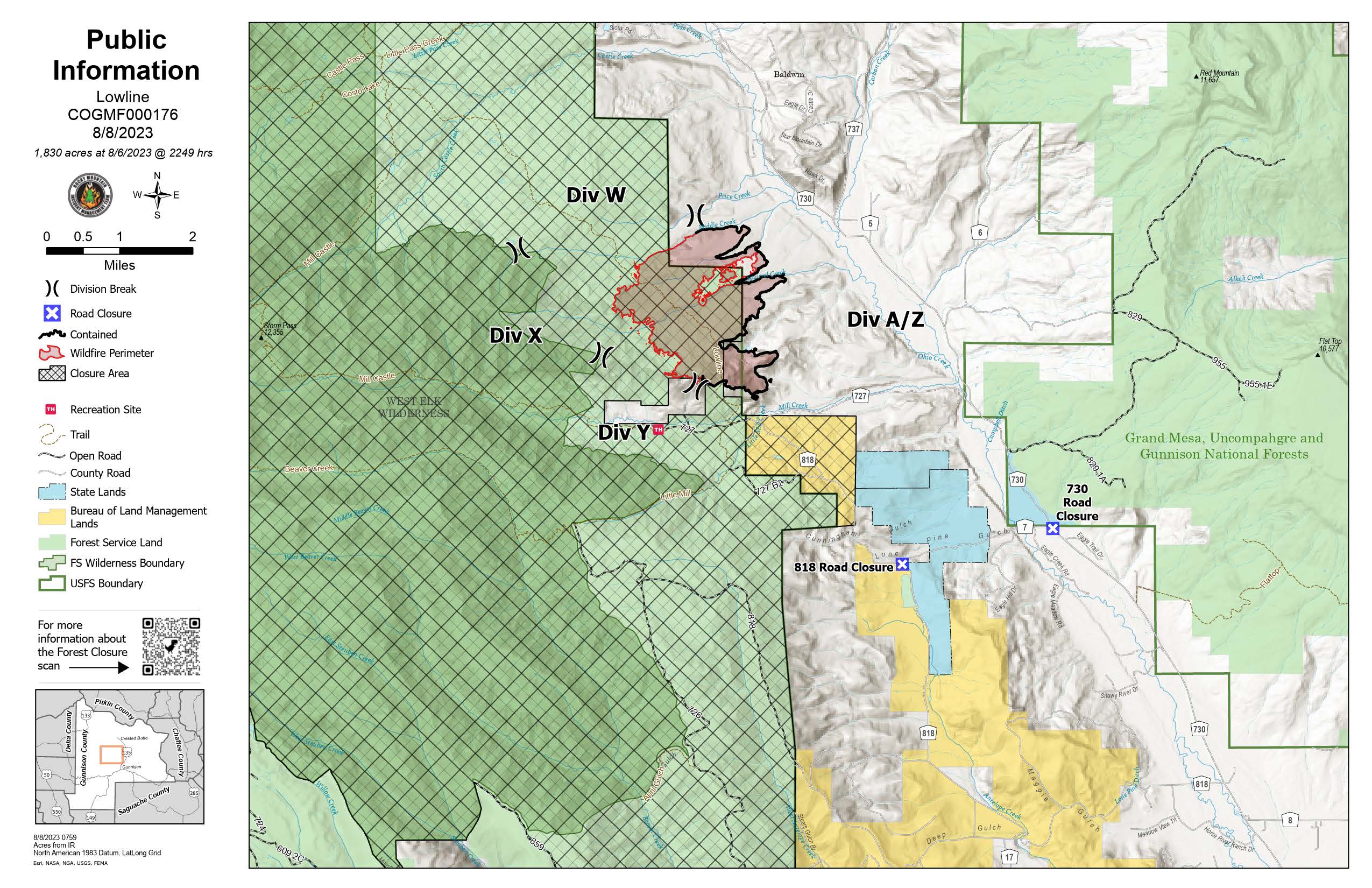
Lowline Fire Update Tuesday August 8 2023
Related Incident: Lowline Fire
Publication Type: News
Lowline Fire Update
Tuesday, August 8, 2023 – 9:00 a.m.
Rocky Mountain Complex Incident Management Team 1
Dan Dallas, Incident Commander
Information Phone: 970-648-4470 (public), 970-765-7123 (media)
Email: 2023.lowline@firenet.gov
Information Staffing Hours: 8 a.m. to 8 p.m.
Special Notes: Today will be the last shift of the Rocky Mountain Complex Incident Management Team, led by Incident Commander Dan Dallas. Command of the Lowline Fire will be transferred to a Type 3 Incident Management Team led by Incident Commander Bryan Gaines at 6:00 am Wednesday. Personnel from the Type 3 Team are on-site shadowing their counterparts on the Rocky Mountain Team to implement a smooth transition.
Current Situation: Yesterday, no perimeter growth occurred and firelines resisted fire growth. Firefighters were prepared for severe fire behavior due to Red Flag conditions. Helicopter water drops were conducted to cool interior fire intensity and reduce spotting over firelines. Pre-staged crews were also moved to augment capacity in Division A/Z.
Today will be the third day of Red Flag conditions, further demonstrating line strength. Planned actions remain the same as yesterday with firefighters located on the perimeter with good visibility and position to respond to fire movement. As fire behavior intensifies firefighters may utilize the helicopter to drop water, reposition resources, and implement other elements of pre-established plans as needed.
Division A/Z: Intense fire behavior was observed as the fire further consumed fuels in the interior islands. Several water drops by a helicopter were necessitated throughout the day to reduce fire intensity and lessen potential for embers to travel outside containment lines. One small spot fire occurred, and firefighters extinguished it rapidly. Firefighting capacity was bolstered with crews from other divisions helping to patrol for fire activity. Today’s plan is the same as yesterday’s as heightened fire activity is expected again.
Division Y: As firefighters observed increasing fire activity between the direct and indirect firelines, helicopters helped to cool the fire by dropping water. No additional actions were needed, and several crews were relocated to provide additional support in Division A/Z. The same approach is planned for today.
Division X: Fire managers have implemented a confinement strategy in the division. Natural barriers and topographic features will support keeping the perimeter confined to an acceptable footprint. No significant growth occurred yesterday.
Division W: Firefighters patrolled for fire activity as it burned through fuels near the northern edge and backed into Middle Creek. Several crews were relocated to Division A/Z providing extra assistance. Tactics remain unchanged today.
Structure Protection: Structure protection crews remained observant and in close proximity to structures near the east side of the fire and will take the same actions again today.
Weather & Fuel Conditions:
After two days of windy conditions, warm temperatures, humidity in the teens, and poor nighttime recovery, fire activity on the interior will be very active again and look similar to yesterday. Under the Red Flag Warning over the fire area, temperatures will be in the upper 70s with humidity in the 15% range and wind gusts up to 35 mph.
Evacuations, Closures, and Fire Restrictions:
A pre-evacuation order is in effect for CR 727, Mill Creek. No other evacuations or pre-evacuations are in place near the fire. For evacuation information, see Gunnison County Emergency Management at www.gunnisoncounty.org. You may sign up to receive emergency alerts on your phones or other devices at: https://bit.ly/3QhZVZg .
National Forest area, road, and trail closure: https://www.fs.usda.gov/Internet/FSE_DOCUMENTS/fseprd1126172.pdf . BLM temporary closure: https://tinyurl.com/5n8s7xee .
County Roads in the fire vicinity are barricaded. In the interest of public safety, fire officials ask visitors to be aware of fire traffic and avoid the area.
Fire restrictions in Gunnison County: none currently.
Smoke Outlook reports: https://outlooks.airfire.org/outlook/ed63b240 .
Lowline Fire Statistics:
Size: 1830 acres
Containment: 55%
Total Personnel: 220
Cause: lightning
Location: 14 mi. NNW of Gunnison, CO
Reported: 8:00 am July 26, 2023
For More Information:
Information Phone: 970-648-4470 (public), 970-765-7123 (media)
Email: 2023.lowline@firenet.gov
InciWeb: https://inciweb.wildfire.gov/incident-information/cogmf-lowline-fire
Facebook: www.facebook.com/GMUGFireInfo
###
August 8 2023 Colt Fire Daily Update
Related Incident:
Publication Type: News
NORTHERN ROCKIES TEAM 5 INCIDENT COMMANDER: JOE SAMPSON
Fire Size: 7179 acres Containment 39 %
CURRENT STATUS
The fire’s containment increased to 39 percent as crews were able to take advantage of quieted fire behavior from the recent moisture and successfully “mop-up” residual heat on the fire’s northeast and eastern edge. Crews also continued “mopping-up” residual heat on the fire near Beaver Lake. Yesterday’s drier weather allowed crews to successfully access the southern edge of the fire to construct line. On the fire’s southwest corner, crews continued handline construction toward Sunset Ridge.
PLANNED ACTION
Crews will “mop-up" remaining residual heat along the fire’s northern and eastern edges between Colt Lake and Beaver Lake. Crews will continue constructing line west to Sunset Ridge on the south flank. Heavy equipment will assist crews with additional line construction on the northwest corner of the fire.
Air operations will be using two unmanned aerial systems (UAS “drones”) over the coming days to map out areas of heat within the fire area. The UAS aircraft is best able to pick up areas of heat within the fire late at night and early in the morning due to lower air temperatures at these times. For this reason, the temporary flight restriction (TFR) for the fire area (FDC 3/7867) has been extended from 8am-10am to a full 24-hour restriction. This restriction is necessary to provide a safe environment for firefighting aircraft operating in the area. If you fly, we can’t!
WEATHER AND FIRE BEHAVIOR
Temperatures remained about five degrees below average yesterday, in the mid-70s, with relative humidities lowering to the mid-30s. However, the fire did exhibit some isolated tree torching interior to the western flank of the fire. Fire weather and behavior is expected to be similar today as yesterday. Thunderstorms are possible tomorrow night with gusts up to 35 mph. By Thursday, sunny, warm weather is likely to return with westerly wind gusts up to 25 mph on ridgetops. As light, grassy fuels dry out, fire activity is likely to increase, with some isolated tree torching expected.