
Oak Grove Fire Daily Update 8082023
Related Incident:
Publication Type: News
Oak Grove Fire Update
Tuesday August 8, 2023
10:30 pm
Size: 400 acres
Containment: 95%
Start Date: August 5, 2023
Cause: Under Investigation
At 3:20 p.m. on Aug. 5, Texas A&M Forest Service received a request for assistance on a fire burning north of San Marcos, Hays County, Texas. The fire is burning in grass and brush fuels, and was initially exhibiting moderate to extreme fire behavior, making runs and spotting in several areas. As of 6:24 p.m. on Aug. 5, the fire jumped the Blanco River and was actively burning on the north side. By 8:47 p.m., fire activity had diminished and forward progression was stopped.
Texas A&M Forest Service has mobilized the following to assist with response efforts: fire managers and miscellaneous overhead, dozers, the Cherokee Interagency Hotshot Crew, engine crews from Texas Intrastate Fire Mutual Aid System (TIFMAS), Emergency Medical Task Force (EMTF) personnel and aircraft, including single engine air tankers and Super Scoopers.
There is a Temporary Flight Restriction (TFR) in place for the area over the fire [NOTAM: FDC 3/8882, https://bit.ly/44Uhymh]. Please avoid the area to provide a safe environment for firefighting aircraft.
Yesterday:
Texas A&M Forest Service crews and helicopters began work this morning around 9:30 am. The Blackhawk helicopter will continue dropping fire retardant over intense heat areas (specific flank/location?) as preparation for ground crew suppression activities. By mid-day, the containment on the south side of the Blanco River was completed, but work continued on the north side of the river. All line construction was completed by 5:00pm and containment was estimated at 75%. Crews continued to patrol and suppress hot or smoldering areas within the containment area until 7:00pm when all resources were released for the night. Containment is now 90%.
Today:
Texas A&M Forest Service and TIFMAS resources arrived on scene at 11:00 am. Engine and hand crews patrolled and conducted heat suppression along containment lines most of the day and by 3:00 pm most of the fire area was contained except some heat along the head of the fire where they focused suppression efforts until this evening. The Oak Grove Fire is now 95% contained and all resources are released for the night.
Weather and Fire Behavior:
Minimum relative humidity values this afternoon will fall to around 27 percent. This morning, winds will blow from the south/southwest around 5-10 mph and increase to 10-15 this afternoon with occasional gusts up to 20+ mph. There is the potential for rapid fire growth this afternoon. Critical Fire Weather Conditions are expected to continue through at least Wednesday.
Evacuations: None
Damages/Injuries: One residence and an unknown number of outbuildings were destroyed. Officials will continue to assess any further reports of damages and provide updates if any new information arises.
Closures: None
Jennings Fire Daily Update 08082023
Related Incident: Jennings Fire
Publication Type: News
Jennings Fire Update
Tuesday, August 8, 2023
10:00 pm
Size: 3,000 acres
Containment: 85%
Start Date: August 7, 2023
Cause: Under Investigation
At 2:11 p.m. on Aug. 7, Texas A&M Forest Service responded to a request for assistance on a 200 acre fire burning 15.5 miles north/northwest of Zapata in Zapata County, Texas. The fire began burning at a moderate rate of speed through grass and brush fuels in an oil field. Firefighters plan to use local roads to work off to box the fire into containment. No structures were directly threatened.
Texas A&M Forest Service has mobilized the following to assist with response: fire managers and miscellaneous overhead, air resources including an air attack plane, single engine air tanker (SEAT) planes, Blackhawk helicopters with buckets and a large air tanker (LAT); engines, dozers and crews from Edinburg and Alice; the Texas Intrastate Fire Mutual Aid System Strike Team (TIFMAS) from Cotulla.
An air attack plane provided the early overview of the fire then directed SEATs, LAT and Helicopters to drop flame retardant and water on the western and southwestern flanks of the fire to provide initial heat suppression. State and Zapata County Dozer crews began constructing containment lines on the northern flanks, tying in with a containment line started by a local equipment operator on the eastern flank. After the fire died down a bit around 7:00 pm, engine crews worked with Zapata County resources to contain the fire on the western flank, off of County Road 3169.
Yesterday:
The Jennings Fire was estimated to be about 2,500 acres in size. Dozer and engine crews worked directly on the western side (left flank), constructing containment lines and conducting heat suppression. The eastern side had two spot fires cross the containment line, but dozer crews were able to contain those fires directly. The fire behavior became more moderate around 10:30 pm and it was estimated to be 60% contained. Command of the fire was transitioned to Incident Commander C. Enriquez at end of shift.
Today:
Dozer crews completed the eastern containment line early this morning around 2:00 am and the Zapata County engine patrolled for remainder of night. Ground crews arrived on scene around 8:00 am and air resources arrived around 10:00 am. The Air Tactical Group Supervisor (ATGS) in the air attack plane observed that the fire had no growth overnight, but there was some interior smoking vegetation and the fire was still creeping within the containment lines.
Dozer crews constructed containment lines around the right “shoulder” of the fire and they had the entire left flank containment line stabilized by 1:30 pm. Crews have continued suppression work most of the day, fighting isolated pockets of heat on the right flank. Dozer crews have also been working to contain a five acre “slopover” (a new fire started outside of the containment area from the original fire) towards the “heel” of the fire. By 10:00 pm tonight the Incident Commander determined the Jennings Fire to be 3,000 acres in size and estimated 85% containment. All Texas A&M Forest Service crew have been released for the night and Zapata County resources will patrol the fire over the remainder of the night.
Weather and Fire Behavior:
Very low minimum relative humidity is expected this afternoon into early evening. Relative humidity values are forecast to drop to around 20 percent by mid afternoon with some recovery by late this evening. Light to moderate southeast winds this morning
will become breezy during the afternoon. Breezy southeast winds are expected to continue through the evening hours. High temperatures today will range between 107 to 110 degrees. Winds are expected to weaken overnight and the relative humidity will recover slowly during the overnight period as well.
Evacuations: None
Damages/Injuries: None
Closures: None
Brady Fire Incident Update for Tuesday August 8 2023
Related Incident:
Publication Type: News
Today’s Date: 08/08/2023
Start Date: 08/06/2023 Location: 7 mi. E of Pine Cause: Unknown, under investigation
Acres – 260 Containment – 0%
Evacuations – SET for Camp Geronimo and Shadow Rim Camp
Structures Damaged – 0 Destroyed – 0
Summary: Fire activity stayed quiet today and an afternoon thunderstorm provide much-needed relief in the form of rain and hail across the fire area. Today a hotshot crew and a Type 2-IA crew went direct along the south and west sides of the fire, establishing containment line with the assistance of a helicopter. Along the northwest side, crews prepped the area for potential firing operations should the fire push that direction. The east side of the fire is hung up in some steep and rugged terrain and for the most part inaccessible. The majority of the workload is on the southeast side with crews conducting structure protection efforts within the Washington Park community and along Forest Road 32. Additionally, crews are working to strengthen and improve fuel breaks with the help of dozer operations in that area. The fire was mapped by air today at 260 acres. The decrease in acreage is due to more accurate mapping. Nearly 300 personnel are assigned to the fire including hotshot crews, hand crews, engines, water tenders, dozers and helicopters. With precipitation forecast for the next few days and a decrease in fire activity, the Department of Forestry and Fire Management (DFFM) along with the Tonto National Forest made the decision to transfer command of the fire to a Type 3 Incident Management Team (IMT) instead of a Type 1 IMT starting Thursday.
Personnel Assigned: 295. Hotshot Crews – 3, Type 2-IA hand crews – 4, Type 2 hand crews – 3, engines – 16, water tenders – 1, dozers – 4, helicopters – 3
Weather: Hot and windy conditions. Outflow winds and lightning associated with possible thunderstorms.
Twitter: https://twitter.com/azstateforestry
Facebook: https://www.facebook.com/arizonaforestry
Media/Public Phone: 602-540-1036
Little Mesa Fire August 8 2023 9PM Update
Related Incident: Little Mesa Fire
Publication Type: News
Little Mesa Fire had increased fire activity today. The fire was transferred over to a Type 3 organization tonight.
Kane Fire Emergency Area Closure
Related Incident: Kane Fire
Publication Type: Closures
EMERGENCY AREA CLOSURE
Pursuant to 16 U.S.C. § 551 and 36 C.F.R. § 261.50 (a), the following acts are prohibited on National Forest System (NFS) lands in the North Kaibab Ranger District of the Kaibab National Forest, described below and shown on the attached map incorporated into this Order as Exhibit A (“Described Area”).
PROHIBITIONS
- Entering or being within the Described Area. 36 C.F.R. § 261.52(e).
EXEMPTIONS
Pursuant to 36 C.F.R. § 261.50 (e), the following persons are exempt from this Order:
- Any Federal, State, or local officer, or member of an organized rescue or firefighting force engaged in the performance of an official duty.
- Persons with Forest Service Permit No. FS-7700-48 (Permit for Use of Roads, Trails, or Areas Restricted by Regulation or Order), specifically exempting them from this Order or a written determination by a Forest Service authorized officer that a permit is not required under 36 C.F.R. § 251.50(e)(1) or (2).
DESCRIBED AREA
As depicted in Exhibit A, all National Forest System lands within the boundary starting at the intersection of State Route 67 and NFSR 205, proceeding east along NFSR 205 to the intersection with NFSR 224, proceeding east along NFSR 224 to the intersection with NFSR 284, proceeding north on NFSR 284 to the intersection with 284C, proceeding north along NFSR 284C to the intersection with BLM-D226, proceeding east along BLM-D226 to the intersection with BLM-D249, proceeding south along BLM-D249 to the intersection with BLM-8910, proceeding southwest along BLM-8910 to the intersection with NFSR 287, proceeding west along NFSR 287 to the intersection of NFSR 220, proceeding south along NFSR 220 to the intersection with NFSR 213, proceeding southwest along NFSR 213 to the intersection with
NFSR 509, proceeding west on NFSR 509 to the intersection with NFSR 487, proceeding northwest on NFSR 487 to the intersection with SR 67, proceeding north along SR 67 back to the point of beginning at the intersection of SR 67 and NFSR 205.
PURPOSE
The purpose of this Order is to provide for the public’s health and safety due to the Kane Fire.
IMPLEMENTATION
- This Order will be in effect beginning at 6:00 AM on August 8, 2023, and shall remain in effect until September 30, 2023, or until rescinded, whichever comes first.
- A map identifying the Described Area, Roads, and Trails is attached and made part of this Order as Exhibit A. For a digital version of this Order and Exhibit A, go to Kaibab National Forest - Alerts & Notices (usda.gov)
- Unless otherwise expressly defined in this Order, the terms used in this Order are defined by the regulations of the Secretary of Agriculture, 36 C.F.R. Chapter II, Parts 200-299. If there are terms in this Order that are not expressly defined in the Order or 36 C.F.R. Chapter II, Parts 200- 299, their meaning shall be determined by their plain language definitions.
- A violation of the above prohibitions is punishable as a Class B misdemeanor by a fine of not more than $5,000 for individuals and $10,000 for organizations, or by imprisonment for not more than six months, or both. 16 U.S.C. § 551; 18 U.S.C. §§ 3559, 3571, and 3581.
- Contact the North Kaibab Ranger District at (928) 643-7395, and the Kaibab National Forest Supervisor’s Office in Williams, AZ at (928) 635-8200, for more information about this Order.
- This Order supersedes any previous Orders prohibiting the same or similar acts in/on the same Described Area, Roads, and Trails.
Done at Williams, Arizona this 9th day of August 2023.
NICOLE BRANTON
Digitally signed by NICOLE BRANTON Date: 2023.08.08
17:45:48 -07'00'
Stage II Fire Restrictions in effect 8923
Related Incident:
Publication Type: Announcement
Fire Danger Prompts Stage II Fire Restrictions Across Northern Idaho
COEUR D’ALENE, Idaho – Beginning at 12:01 a.m. on Wednesday, August 9, Stage II Fire Restrictions will be in effect on lands managed or administered by the US Forest Service, Idaho Panhandle National Forests, the Bureau of Land Management, the Coeur d’Alene Tribe, the Idaho Department of Lands, and the U.S. Fish and Wildlife Service in Benewah, Bonner, Boundary, Kootenai, and Shoshone Counties. This also includes National Forest System lands in Washington and Montana that are administered by the Idaho Panhandle National Forests. Restrictions will remain in effect until further notice.
Moderate to severe drought conditions coupled with persistent high temperatures have raised the fire danger rating to very high and extreme across northern Idaho. The local Coeur d’Alene dispatch area recently saw an increase to Preparedness Level 4 out of 5, and conditions nationally are Preparedness Level 3. This means multiple geographic areas are experiencing large wildfires, suppression resources are being carefully prioritized, and the majority of other firefighting personnel and equipment are committed to wildland fire incidents. These conditions have prompted Stage II fire restrictions to be implemented in accordance with the criteria established in the 2023 Idaho Fire Restrictions Plan for all lands within the Coeur d’Alene Dispatch area.
Under Stage II fire restrictions, the following acts are prohibited on the restricted private, tribal, state and federally managed or protected lands, roads, and trails:
1. Building, maintaining, attending, or using a fire, campfire, or stove fire.
2. Smoking, except within an enclosed vehicle or building, a designated recreation site or while stopped in an area at least three feet in diameter that is barren or cleared of all flammable materials.
3. Operating motorized vehicles off designated roads and trails in accordance with existing travel management plans for non-commercial purposes, including ATVs, UTVs, and pickups.
4. The following acts are prohibited from 1:00 p.m. to 1:00 a.m.: (A patrol is required for one hour following cessation of all work as described in a, b, and c below.)
a. Operating a chainsaw or other equipment powered by an internal combustion engine for felling, bucking, skidding, processing, log loading and hauling, road building and woodcutting or any other activity employing the use of an internal combustion engine or off-road activity associated with industrial operations or fire wood gathering.
b. Blasting, welding, or other activities that generate flame or flammable material.
c. Using an explosive.
The following are exemptions to the Stage II Fire Restrictions:
1. Persons with a written permit that specifically authorizes the otherwise prohibited act.
2. Persons using a fire or stove fire fueled solely by liquid petroleum or LPG fuels. Such devices, including propane campfires, may be used only in an area cleared of flammable material.
3. Persons using a generator with an approved spark arrester on areas that are cleared of all flammable materials within three feet of the generator.
4. Log loading and hauling only from landings and existing roads.
5. Private landowners using charcoal (disposed of properly) or propane barbecues on their own lands.
6. Normal operations on crop lands.
7. Emergency repair of public utilities and railroads as per conditions in Stage II Exemptions for Public Utilities and Railroads.
8. Any federal, state, or local officer, or member of an organized rescue or firefighting force, in the performance of an official duty.
9. Persons conducting activities in those designated areas where the activity is specifically authorized by written posted notice.
10. All land within a city boundary (unless otherwise restricted).
With the extreme temperatures and drought the region is experiencing, fire managers are asking the public to be extra cautious when spending time outdoors. As a reminder, you should never use fireworks on state and private forestland and rangeland and on public lands, roads, and trails. Possession and/or use of fireworks is always prohibited on federal public lands.
To view the Idaho Fire Restrictions Plan and a statewide map with current information regarding fire restrictions, please visit https://www.idl.idaho.gov/fire-management/fire-restrictions-finder.
###
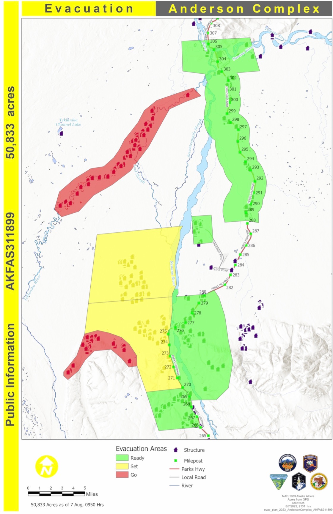
Denali Borough Moves City of Anderson from SET to READY
Related Incident: Anderson Complex
Publication Type: Announcement
Aug. 8, 2023
The Denali Borough moved the City of Anderson from SET to READY status today. Residents of Anderson should remain alert and ready for the possible need to evacuate.
The current evacuation statuses are:
![]() Areas in Evacuation Status Level 3 - GO
Areas in Evacuation Status Level 3 - GO
(EVACUATE NOW - DO NOT DELAY)
![]() The Teklanika River and all residents along the Teklanika River.
The Teklanika River and all residents along the Teklanika River.
![]() ALL residents in the Clear Sky Homestead (not the Clear Sky Lodge), including those adjacent to Rose Hip Creek
ALL residents in the Clear Sky Homestead (not the Clear Sky Lodge), including those adjacent to Rose Hip Creek
The Tri-Valley School is available for evacuation parking and will be available as an evacuation center, if needed
![]() Areas in Evacuation Status Level 2 - SET
Areas in Evacuation Status Level 2 - SET
(BE SET TO LEAVE AT A MOMENT'S NOTICE)
![]() Residents that use and road west of the George Parks Highway between Milepost 270 and the Rex Bridge
Residents that use and road west of the George Parks Highway between Milepost 270 and the Rex Bridge
![]() Areas in Evacuation Status Level 1 - READY
Areas in Evacuation Status Level 1 - READY
(BE READY FOR POSSIBLE EVACUATION)
![]() Residents of the City of Anderson
Residents of the City of Anderson
![]() Residents of the City of Nenana
Residents of the City of Nenana
![]() Residents who access their property off the George Parks Highway corridor between milepost 288 and milepost 306
Residents who access their property off the George Parks Highway corridor between milepost 288 and milepost 306
![]() Residents who access their property from the west side of the George Parks Highway between milepost 266 and milepost 270, including June Creek and Bear Creek
Residents who access their property from the west side of the George Parks Highway between milepost 266 and milepost 270, including June Creek and Bear Creek
![]() Residents who access their property off the Parks Highway corridor from the Rex Bridge to milepost 280
Residents who access their property off the Parks Highway corridor from the Rex Bridge to milepost 280
August 8 2023 Update
Related Incident: American Mesa Fire
Publication Type: News
TAOS, N.M., Aug. 8, 2023 – A Type 3 Incident Management Team, Nevada Team 2, took command of the fire at 6:00 a.m. on August 8. Fire crews have made excellent progress in holding the fire at 756 acres, with 25% containment.
“We received an outstanding hand off from Carson National Forest Operations,” said Incident Commander Brian Kitchen, “We want to ensure crews are staying safe while keeping the fire at bay during this transition.”
There are currently 160 personnel on scene including hot shots, engines, and hand crews. Crews are actively engaged on the fire line working on mop up operations. There are no immediate threats to structures.
The forecast is more favorable than originally predicted which will help firefighters further contain the fire. Mostly clear and sunny skies are forecast on Wednesday, with a 0% chance of showers. Temperatures may be cooler with breezy conditions and occasional wind gusts up to 22 mph in the afternoon.
The public can get updates for the American Mesa Fire on InciWeb, New Mexico Fire Information and Carson National Forest social media channels on Facebook and X (formerly Twitter).
August 8 Fire Update
Related Incident: Bear Creek Fire
Publication Type: News
Fire start date: August 1, 2023
Fire size today: 143 acres
Containment: 0%
Location: 23 miles Northwest of Pagosa Springs, Colorado
Personnel: 24
Cause: Lightning
Management: Suppression
Evacuation Information:
There are NO pre-evac/evacuation orders at this time. Local residents should follow incident information and updates.
Closures:
Little Sand Trail (NFST#591) from Mosca Road
Shaw Creek Trail (NFST#584)
Falls Creek Trail (NFST#673)
Latest Smoke Outlook:
https://fire.airnow.gov/?aqi_v=2&m_ids=&pa_ids=#
INCIDENT OBJECTIVES:
- Safety of Firefighters and the public will be the highest priority throughout all phases of the incident.
- Managing hazards to fire fighters and the public by utilizing a risk-based approach to decision making on a continual basis.
Utilize appropriate fire strategies to minimize fire impacts to critical community infrastructure, private lands and improvements to reduce the potential for adverse health, social, financial, and economic hardships. These include:
• Private lands and infrastructure within the Weminuche Creek River drainages
• Utilities serving these communities
• Smoke impacts to local communities and US Highway 160
• Natural resources, cultural, historic sites, and recreationists.
YESTERDAY’S ACCOMPLISHMENTS:
- Local ground fire resources continued to directly monitor fire growth and directional spread. Advised leadership of potential impacts to values at risk within the general fire area.
- Continue to gain situational awareness and develop operational objectives for future firefighting operations when ordered fire resources arrive.
- Infrared, heat-detection equipped aircraft flew the fire and provided fire leadership accurate fire size and presence of spot fires (if any).
TODAY’S PLAN:
- San Juan Type 3 incident Management Team (IMT) assumed fire command at 6am today, August 8th.
- IMT operational leadership will recon the fire area with aviation resources assigned to the fire, developing real-time situational awareness.
- Firefighting crews in the Weminuche Valley area will assess risk level to private land/structures and develop structure protection plans for future operational shifts.
- Incoming firefighting resources will be briefed and assigned operational assignments. Significant national competition for resources on higher-priority fires has led to difficulty in obtaining the number/types of resources needed.
- A National Incident Management Organization Team has been ordered to assume command of the incident August 12th at 0600, providing additional capacity and oversight to the incident.
WEATHER:
Elevated fire weather conditions and gusty winds will be present, with increasing chances of rainfall this afternoon. The weather trend includes daily chances of rain showers during the afternoon through the end of the week.
Settings - change map background and toggle additional layers
Filter - control incident types displayed on map.
Zoom to your location
Reset map zoom and position
Could not determine your location.
Show Legend
 Wildfire
 Prescribed Fire
 Burned Area
Response
Burned Area
Response Other
Other