
Stage II Fire Restrictions in effect 8923
Related Incident:
Publication Type: Announcement
Fire Danger Prompts Stage II Fire Restrictions Across Northern Idaho
COEUR D’ALENE, Idaho – Beginning at 12:01 a.m. on Wednesday, August 9, Stage II Fire Restrictions will be in effect on lands managed or administered by the US Forest Service, Idaho Panhandle National Forests, the Bureau of Land Management, the Coeur d’Alene Tribe, the Idaho Department of Lands, and the U.S. Fish and Wildlife Service in Benewah, Bonner, Boundary, Kootenai, and Shoshone Counties. This also includes National Forest System lands in Washington and Montana that are administered by the Idaho Panhandle National Forests. Restrictions will remain in effect until further notice.
Moderate to severe drought conditions coupled with persistent high temperatures have raised the fire danger rating to very high and extreme across northern Idaho. The local Coeur d’Alene dispatch area recently saw an increase to Preparedness Level 4 out of 5, and conditions nationally are Preparedness Level 3. This means multiple geographic areas are experiencing large wildfires, suppression resources are being carefully prioritized, and the majority of other firefighting personnel and equipment are committed to wildland fire incidents. These conditions have prompted Stage II fire restrictions to be implemented in accordance with the criteria established in the 2023 Idaho Fire Restrictions Plan for all lands within the Coeur d’Alene Dispatch area.
Under Stage II fire restrictions, the following acts are prohibited on the restricted private, tribal, state and federally managed or protected lands, roads, and trails:
1. Building, maintaining, attending, or using a fire, campfire, or stove fire.
2. Smoking, except within an enclosed vehicle or building, a designated recreation site or while stopped in an area at least three feet in diameter that is barren or cleared of all flammable materials.
3. Operating motorized vehicles off designated roads and trails in accordance with existing travel management plans for non-commercial purposes, including ATVs, UTVs, and pickups.
4. The following acts are prohibited from 1:00 p.m. to 1:00 a.m.: (A patrol is required for one hour following cessation of all work as described in a, b, and c below.)
a. Operating a chainsaw or other equipment powered by an internal combustion engine for felling, bucking, skidding, processing, log loading and hauling, road building and woodcutting or any other activity employing the use of an internal combustion engine or off-road activity associated with industrial operations or fire wood gathering.
b. Blasting, welding, or other activities that generate flame or flammable material.
c. Using an explosive.
The following are exemptions to the Stage II Fire Restrictions:
1. Persons with a written permit that specifically authorizes the otherwise prohibited act.
2. Persons using a fire or stove fire fueled solely by liquid petroleum or LPG fuels. Such devices, including propane campfires, may be used only in an area cleared of flammable material.
3. Persons using a generator with an approved spark arrester on areas that are cleared of all flammable materials within three feet of the generator.
4. Log loading and hauling only from landings and existing roads.
5. Private landowners using charcoal (disposed of properly) or propane barbecues on their own lands.
6. Normal operations on crop lands.
7. Emergency repair of public utilities and railroads as per conditions in Stage II Exemptions for Public Utilities and Railroads.
8. Any federal, state, or local officer, or member of an organized rescue or firefighting force, in the performance of an official duty.
9. Persons conducting activities in those designated areas where the activity is specifically authorized by written posted notice.
10. All land within a city boundary (unless otherwise restricted).
With the extreme temperatures and drought the region is experiencing, fire managers are asking the public to be extra cautious when spending time outdoors. As a reminder, you should never use fireworks on state and private forestland and rangeland and on public lands, roads, and trails. Possession and/or use of fireworks is always prohibited on federal public lands.
To view the Idaho Fire Restrictions Plan and a statewide map with current information regarding fire restrictions, please visit https://www.idl.idaho.gov/fire-management/fire-restrictions-finder.
###
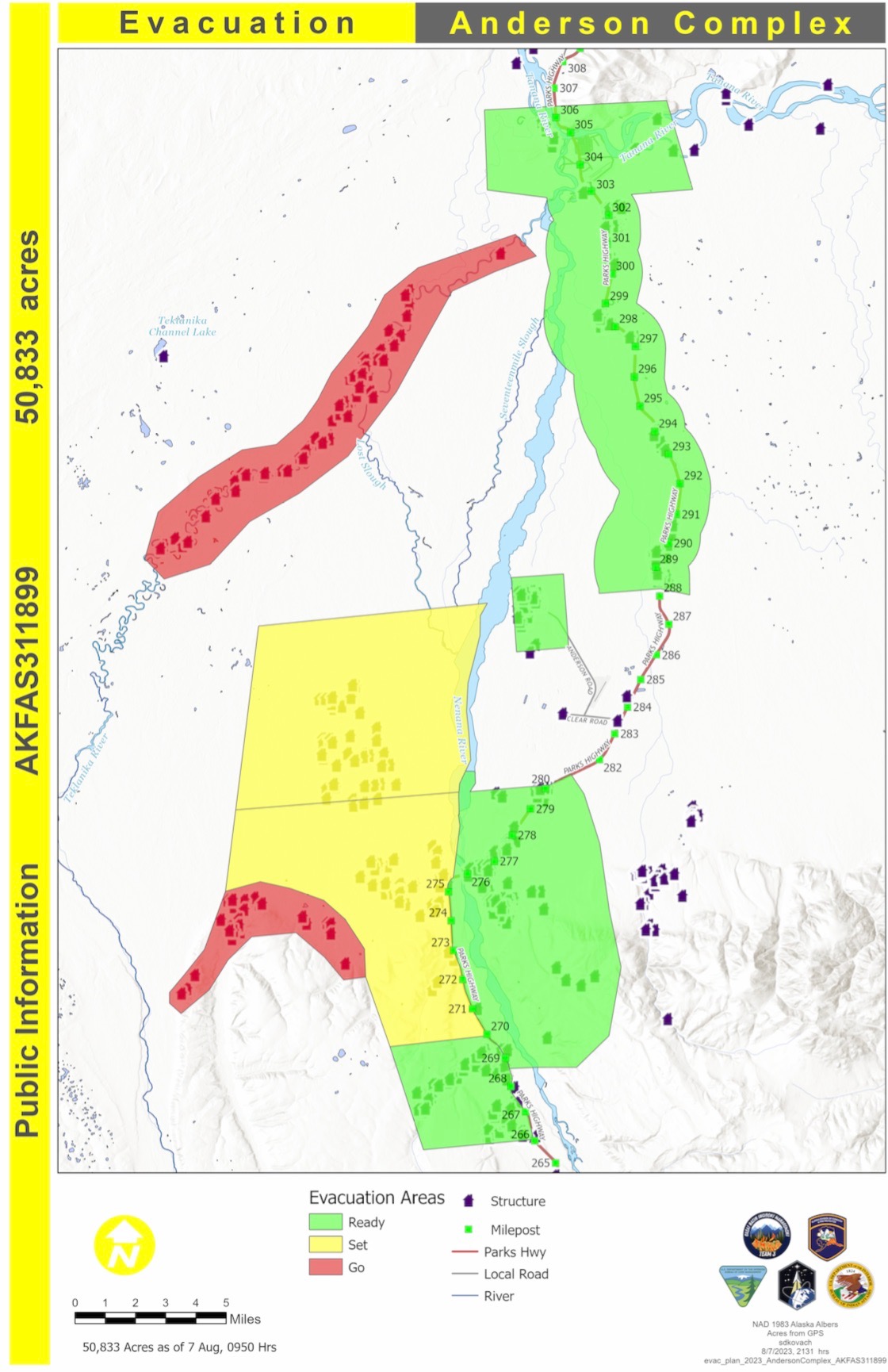
Denali Borough Moves City of Anderson from SET to READY
Related Incident: Anderson Complex
Publication Type: Announcement
Aug. 8, 2023
The Denali Borough moved the City of Anderson from SET to READY status today. Residents of Anderson should remain alert and ready for the possible need to evacuate.
The current evacuation statuses are:
![]() Areas in Evacuation Status Level 3 - GO
Areas in Evacuation Status Level 3 - GO
(EVACUATE NOW - DO NOT DELAY)
![]() The Teklanika River and all residents along the Teklanika River.
The Teklanika River and all residents along the Teklanika River.
![]() ALL residents in the Clear Sky Homestead (not the Clear Sky Lodge), including those adjacent to Rose Hip Creek
ALL residents in the Clear Sky Homestead (not the Clear Sky Lodge), including those adjacent to Rose Hip Creek
The Tri-Valley School is available for evacuation parking and will be available as an evacuation center, if needed
![]() Areas in Evacuation Status Level 2 - SET
Areas in Evacuation Status Level 2 - SET
(BE SET TO LEAVE AT A MOMENT'S NOTICE)
![]() Residents that use and road west of the George Parks Highway between Milepost 270 and the Rex Bridge
Residents that use and road west of the George Parks Highway between Milepost 270 and the Rex Bridge
![]() Areas in Evacuation Status Level 1 - READY
Areas in Evacuation Status Level 1 - READY
(BE READY FOR POSSIBLE EVACUATION)
![]() Residents of the City of Anderson
Residents of the City of Anderson
![]() Residents of the City of Nenana
Residents of the City of Nenana
![]() Residents who access their property off the George Parks Highway corridor between milepost 288 and milepost 306
Residents who access their property off the George Parks Highway corridor between milepost 288 and milepost 306
![]() Residents who access their property from the west side of the George Parks Highway between milepost 266 and milepost 270, including June Creek and Bear Creek
Residents who access their property from the west side of the George Parks Highway between milepost 266 and milepost 270, including June Creek and Bear Creek
![]() Residents who access their property off the Parks Highway corridor from the Rex Bridge to milepost 280
Residents who access their property off the Parks Highway corridor from the Rex Bridge to milepost 280
August 8 2023 Update
Related Incident: American Mesa Fire
Publication Type: News
TAOS, N.M., Aug. 8, 2023 – A Type 3 Incident Management Team, Nevada Team 2, took command of the fire at 6:00 a.m. on August 8. Fire crews have made excellent progress in holding the fire at 756 acres, with 25% containment.
“We received an outstanding hand off from Carson National Forest Operations,” said Incident Commander Brian Kitchen, “We want to ensure crews are staying safe while keeping the fire at bay during this transition.”
There are currently 160 personnel on scene including hot shots, engines, and hand crews. Crews are actively engaged on the fire line working on mop up operations. There are no immediate threats to structures.
The forecast is more favorable than originally predicted which will help firefighters further contain the fire. Mostly clear and sunny skies are forecast on Wednesday, with a 0% chance of showers. Temperatures may be cooler with breezy conditions and occasional wind gusts up to 22 mph in the afternoon.
The public can get updates for the American Mesa Fire on InciWeb, New Mexico Fire Information and Carson National Forest social media channels on Facebook and X (formerly Twitter).
August 8 Fire Update
Related Incident: Bear Creek Fire
Publication Type: News
Fire start date: August 1, 2023
Fire size today: 143 acres
Containment: 0%
Location: 23 miles Northwest of Pagosa Springs, Colorado
Personnel: 24
Cause: Lightning
Management: Suppression
Evacuation Information:
There are NO pre-evac/evacuation orders at this time. Local residents should follow incident information and updates.
Closures:
Little Sand Trail (NFST#591) from Mosca Road
Shaw Creek Trail (NFST#584)
Falls Creek Trail (NFST#673)
Latest Smoke Outlook:
https://fire.airnow.gov/?aqi_v=2&m_ids=&pa_ids=#
INCIDENT OBJECTIVES:
- Safety of Firefighters and the public will be the highest priority throughout all phases of the incident.
- Managing hazards to fire fighters and the public by utilizing a risk-based approach to decision making on a continual basis.
Utilize appropriate fire strategies to minimize fire impacts to critical community infrastructure, private lands and improvements to reduce the potential for adverse health, social, financial, and economic hardships. These include:
• Private lands and infrastructure within the Weminuche Creek River drainages
• Utilities serving these communities
• Smoke impacts to local communities and US Highway 160
• Natural resources, cultural, historic sites, and recreationists.
YESTERDAY’S ACCOMPLISHMENTS:
- Local ground fire resources continued to directly monitor fire growth and directional spread. Advised leadership of potential impacts to values at risk within the general fire area.
- Continue to gain situational awareness and develop operational objectives for future firefighting operations when ordered fire resources arrive.
- Infrared, heat-detection equipped aircraft flew the fire and provided fire leadership accurate fire size and presence of spot fires (if any).
TODAY’S PLAN:
- San Juan Type 3 incident Management Team (IMT) assumed fire command at 6am today, August 8th.
- IMT operational leadership will recon the fire area with aviation resources assigned to the fire, developing real-time situational awareness.
- Firefighting crews in the Weminuche Valley area will assess risk level to private land/structures and develop structure protection plans for future operational shifts.
- Incoming firefighting resources will be briefed and assigned operational assignments. Significant national competition for resources on higher-priority fires has led to difficulty in obtaining the number/types of resources needed.
- A National Incident Management Organization Team has been ordered to assume command of the incident August 12th at 0600, providing additional capacity and oversight to the incident.
WEATHER:
Elevated fire weather conditions and gusty winds will be present, with increasing chances of rainfall this afternoon. The weather trend includes daily chances of rain showers during the afternoon through the end of the week.
Settings - change map background and toggle additional layers
Filter - control incident types displayed on map.
Zoom to your location
Reset map zoom and position
Could not determine your location.
Show Legend
 Wildfire
 Prescribed Fire
 Burned Area
Response
Burned Area
Response Other
Other
Lookout Fire
Unit Information
Incident Contacts
Salmon Fire Forest Closure Order and Map
Related Incident: Salmon Fire
Publication Type: Closures
UNITED STATES DEPARTMENT OF AGRICULTURE
FOREST SERVICE
WILLAMETTE NATIONAL FOREST
ORDER # 06-18-10-23-16
FOREST ORDER
SALMON FIRE EMERGENCY AREA CLOSURE
Pursuant to 16 U.S.C. § 551 and 36 C.F.R. § 261.50(a) and (b), and to provide for public safety, the
following acts are prohibited on the National Forest System (“NFS”) areas, roads, and trails described
below within the administrative boundaries of the Willamette National Forest. This Order is effective on
August 8, 2023, through October 24, 2023, unless rescinded sooner.
PROHIBITIONS:
1. Being on the road. 36 CFR § 261.54(e)
2. Being on a trail. 36 CFR § 261.55(a)
3. Entering into or being upon National Forest System Lands closed for the protection of public
health or safety. 36 CFR § 261.53(e)
CLOSURE AREA:
The closure area is located within the State of Oregon, Lane County, and within the Administrative
Boundaries of the Willamette National Forest. The closure applies to the NFS areas, roads, and trails and
trailheads described below. The closure area is depicted on the attached map, which is incorporated into
this order as “Exhibit A”, all roads, trails, campgrounds, and rec sites in this closure area are closed. Roads
are incorporated into this order as “Exhibit B” and recreation sites, trails and campgrounds incorporated
into this order as “Exhibit C”.
Area Closure Description
In Township 21S, Range 3E, Section 14, starting at the junction of FS Road 24 and Forest Road 2404. The
closure boundary proceeds east along Forest Road 24 approximately 5 miles to the intersection with
Forest Road 2409. The closure boundary then follows Forest Road 2409 northwest until it reaches the
intersection with Forest Road 1931. The boundary then follows Forest Road 1931 northeast
approximately 1.8 miles to the intersection with Forest Road 1931720. The Boundary then proceeds
northeast for 1.3 miles to where it crosses Sixth creek in Township 20S, Range 4E, Section 16. The Closure
then follows sixth creek west until it crosses Forest Road 1928. The Closure Boundary then follows Forest
Road 1928 Southwest until it reaches the Forest Boundary. The Closure Boundary is then tied to the
Forest Boundary as proceeds East, South, West, and then due south to Forest Road 24 and back to the
point of origin.
EXEMPTIONS:
Pursuant to 36 CFR § 261.50(e), the following persons are exempt from this Order:
(1) Persons with Forest Service Permit No. FS-7700-48 (Permit for Use of Roads, Trails, or Areas
Restricted by Regulation or Order) specifically exempting them for this Order.
(2) Any Federal, State, or Local Officer, or member of organized rescue or fire fighting force in the
performance of an official duty.
These prohibitions are in addition to the general prohibitions in 36 CFR Part 261, Subpart A.
Violations of these prohibitions are punishable by a fine of not more than $5,000.00 for an individual
or $10,000.00 for a corporation or imprisonment for not more than six months or both. 16 U.S.C. § 551
and 18 U.S.C. §§ 3551, 3559, 3571, and 3581.
Executed in Springfield, Oregon on this 8th day of August 2023
Dave Warnack
Forest Supervisor
Willamette National Forest
Margarita Fire Daily Update August 8
Related Incident: Margarita Fire
Publication Type: News
(MOCLIPS, Wash.) – The Margarita Fire started August 2nd at approximately 12:30am on the Quinault reservation, approximately 1.5 miles NE of Moclips. It is mostly burning in a timber sale unit that is a mix of cedar slash and standing trees, surrounded by heavy timber. Western Washington Type 3 Incident Management Team assumed command of the fire on August 4th.
The fire is currently 61 acres and 50% contained. Crews yesterday mopped up approximately 50 feet in from fire lines. Mopping up is extinguishing or removing burning material near control lines, felling snags, and trenching logs to prevent rolling after an area has burned, to make a fire safer and help reduce residual smoke. Some of the heavy timber inside the fire area will continue to burn due to
substantial safety concerns with puting firefighters into those areas. There have been no injuries to date on the Margarita Fire and we are working hard to keep everyone healthy and safe! Heavy equipment broke up and scatered slash piles to help reduce the threat from unburned material inside the fire area. Some of the heavy equipment completed its work and will depart the fire area today. As of yesterday evening, 119 people, eight engines, and two helicopters were working to suppress the fire.
The objective today is to continue improving and reinforcing fire lines, mopping up and scatering fuels within the fire perimeter. The east edge of the fire contains many tall, dangerous trees and snags, and mop up in this area is hindered because of the extreme risk to firefighters. Additional work today will reduce and spread out fuels outside the eastern containment perimeter to decrease the chance of fire escape in that location.
The only evacuation warning is a Level 2 – Get Set – for the community of Quinault Village, also known as Moclips Estates. Residents should have essentials packed and be ready to go if conditions change.
Weather today is forecast to be partly sunny with a high temperature of 68 degrees. Winds will be out of the west 5-6 mph. Light rain is predicted tonight, totaling approximately 0.15 inches.
You can support firefighting efforts by continuing to drive safely in the fire area, along Highway 109 and the Moclips Highway. Please look out for fire personnel entering and exiting the roads.
August 8 2023 Buckskin 2 Fire Update
Related Incident:
Publication Type: Announcement
Buckskin 2 Fire
Idaho Panhandle National Forests, Sandpoint Ranger District Fire Information: 208-557-8813
https://inciweb.nwcg.gov/incident-information/idipf-buckskin-2-fire
Type 3 Incident Commander, John Ramsey
August 8, 2023
Location: Located approximately 8 miles due south of Clark Fork, ID on Delyle Ridge, between Twin Creek and Dry Creek, south of Highway 200 Start Date: 8/4/2023 Cause: Under Investigation Size: 185 acres (estimated) Containment: 0% Total Personnel: 80 Engines: 7 Hand Crews: 2 Modules: 3 Heavy Equipment: Dozer
The primary objectives for fire officials managing the Buckskin 2 Fire are firefighter and public safety while working to keep it as small as possible. The fire is estimated at 185 acres but due to the increase in fires around the nation, an infrared flight to accurately map the fire has not yet occurred. Crews have begun to build direct handlines along the east and west flanks of the fire, while dozers are constructing indirect line on the north and south side of the fire. The fire remains roughly 1.8 miles from the nearest residence. Fire crews will begin assessing structure protection work today on Dry Creek.
Yesterday, the fire was active with some single and group tree torching. Aircraft is being shared with fires around the area but will be available as needed today.
EVACUATION STATUS
The Bonner County Sheriff’s Office issued a READY evacuation notice for the residents of Twin Creek Rd and Rearden Rd in Clark Fork. Sign up for Bonner County Sheriff’s Office emergency messaging through NIXLE at www.nixle.com.
CLOSURES AND SPECIAL MESSAGES
A Forest Closure Order is officially in effect for roads associated with the Buckskin Fire; the intersection of USFS road 203 and 332, the intersection of 1021 and 332 as well as roads 1533 and 306 in Clark Fork. UTV trail 77 is closed as it goes right into the drainage where the fire is burning. The public is prohibited from the general area for firefighter safety and practice caution while driving near firefighters and apparatuses.
Stage II Fire Restrictions will be going into effect at 12:01 a.m. on Wednesday, 8/9. To view the Idaho Fire Restrictions Plan and a statewide map with current information regarding fire restrictions, please visit https://www.idl.idaho.gov/fire-management/fire-restrictions-finder.
Drone Restrictions. For the safety of our aerial resources and firefighters on the ground, please do not fly unmanned aircraft (drones) in the fire vicinity. If you fly, we can't.
WEATHER
The fire received light to moderate precipitation yesterday. A chance of scattered showers and thunderstorms is predicted again. Partly sunny with a high of 82 degrees and west winds around 8 mph are forecasted.
Ridge Creek Fire Daily Update for August 8 2023
Related Incident:
Publication Type: News
Ridge Creek Fire
Idaho Panhandle National Forests, Coeur d’Alene River Ranger District
Fire Information: 208-953-7022
Media Information: 989-292-9373
https://inciweb.nwcg.gov/incident-information/idipf-ridge-creek
August 8, 2023
Location: Approximately 3.5 miles east of the north tip of Hayden Lake, along the Hayden Creek Road (FSR 437) in the Ridge Creek drainage,
Start Date: 8/3/2023 Cause: Human/Under Investigation Size: 1,200 acres Containment: 0%
Total Personnel: 96 Engines: 6 Heavy Equipment: 6 Crews: 2 Timber Taskforces
On Monday 08/07/23, the fire received wetting rains which slowed the fire for the short term. Due to the lack of sustained moisture and anticipated weather conditions, it is likely that the fire will become more active in the coming days. Yesterday, hand crews worked on the south end of the fire along Forest Service Road 437/Hayden Creek. Mechanical lines were placed yesterday in the area of FSR 428. Road work was conducted on FSR 437 to improve access and to build contingency line. Work was delayed due to safety concerns during the thunderstorms, but crews were still able to complete the plan for the shift. The infrared (IR) flight scheduled for last night was canceled due to thunderstorms in the area; fire size has not been updated due to the lack of an IR flight.
Today, crews will continue to reinforce the FSR 437 fire line, and the mechanical lines constructed with heavy equipment will be extended north towards Hudlow Saddle. Crews will be scouting in the area of FSR 406 to provide additional fireline support northwest of the current fire location. An IR flight has been requested again for this evening.
EVACUATION STATUS
There have been no changes to the evacuation status since the last update. A message from the Kootenai County Emergency Management: Out of an abundance of caution, residents within the boundary (see attached map) are being provided with a GET READY notification. The Ridge Creek Fire is in your area and it would be wise to consider planning and or packing in the event an evacuation becomes necessary. Residents are urged to create and maintain a defensible space and harden their home against the potential for wildfire. More information will be forthcoming as it becomes available. Please continue to monitor official sources and call 208-446-2292 for any questions regarding evacuations. Follow Kootenai County Emergency Management Facebook Page for updates and sign up for automated Kootenai Alert for emergency alerts. https://www.kcsheriff.com/186/Emergency-Management
CLOSURES AND SPECIAL MESSAGES
Firefighting aircraft are still actively engaged on multiple fires in the area and will continue to use area waterways, including Hayden Lake, for fire suppression efforts. All lake users should be on the lookout for approaching aircraft. If emergency firefighting aircraft are in the area, boaters should clear the center of the lake and move toward the shoreline.
The Idaho Panhandle National Forests issued an emergency closure (Closure Order #01-04-03-23-002) effective August 4, 2023. This Order is for public and firefighter safety due to heavy fire traffic on the area impacted on the Coeur d’Alene River Ranger District, and prohibits all methods of travel (foot, mechanized, motorized and stock) on Forest Service Roads 392, 428A, 437, 1511, 1530, 1552, 1587 and Forest Service Roads 206 and 406 north of their junction, Forest Service Trails 69, 78, 234, and 802 as well as within the described area.
WEATHER AND FIRE BEHAVIOR
A warm drying trend will start today. Temperatures today will see a high of 73 degrees, with southwest winds between 5 to 8 mph, gusting to 17 mph. Minimum relative humidity (RH) today will be 41%.
Little Mesa Fire Update August 8 2023
Related Incident: Little Mesa Fire
Publication Type: News
Little Mesa Fire Update - August 8, 2023
Location: Approx. 15 miles west, southwest of Delta, CO, Dominguez Escalante National Conservation Area
Jurisdiction: Bureau of Land Management Discovered: July 31, 2023, 11:00 AM
Cause: Lightning Vegetation Type: Pinyon pine, Juniper, sagebrush, and grass
Estimated Size: 300-acre Containment: 0%
Total Personnel: 60 Full Suppression Fire
NOTICE TO THE PUBLIC: Air operations are being conducted on the Little Mesa Fire. For your safety, please stay out of the Pothole Recreation Area. The helicopters will be using this water source to dip water from the potholes for fire suppression. The pilot needs to be focused on conducting this mission safely and is concerned for the public safety. Firefighters are overseeing the operation at the Potholes.
Current Situation: The Little Mesa Fire is a full suppression fire with a confine and contain strategy that provides for firefighter safety. Yesterday, red flag conditions continued to push the fire towards Dry Mesa which is the desired direction. Last night firefighters successfully fired out vegetation along the Tatum Ridge Road from the northwest fire edge towards the west to protect values at risk in Escalante Canyon. Fire resources were able to complete 90% of the indirect handline and anticipate completion today.
Another round of red flag conditions will be in effect from noon to 9 PM. The fire will receive stronger wind gusts today with hot and dry conditions. This combination will provide critical conditions to the area this afternoon. Wednesday will remain mostly dry with weaker winds.
Evacuations and Closures: No evacuations or closure orders have been issued.
Smoke: Smoke is visible from surrounding areas and Highway 50 and C37 Road. Go to https://fire.airnow.gov to get updated smoke conditions in North America.
Aviation Safety: Aircraft may be used over the Little Mesa Fire air space. Fire aviation resources are flying at different altitudes and speeds. Pilots should exercise caution when flying near wildfires to keep everyone safe. Unmanned aircraft systems (UAS) or drones must never fly near wildfires, as UAS are difficult to see and drone pilots have no way of communicating with firefighting aircraft. The only UAS or drones able to fly are agency owned and operated and have been assigned to work on the wildfire and have communication with air operations. Remember if you fly, we can’t!
For updated information follow our social media outlets:
Facebook: @BLMMontroseFireUnit
Twitter: @SWD_Fire
Montrose Interagency Dispatch website: www.wildwebe.net/?dc_name=COMTC