
Hungry Horse Reservoir Closure Effective August 8th
Related Incident:
Publication Type: Closures
HUNGRY HORSE RESERVOIR CLOSED DUE TO FIRE ACTIVITY
Hungry Horse Reservoir will be closed beginning August 8, 2023. All National Forest System lands in the area and National Forest System roads 38 and 895 will be closed to public use for public and firefighter safety.
FS Road #38 (East Side Road #38) is closed to all public traffic east of the junction of FS Road #497 (Desert Mountain Road) and East Side Road #38. West Side South Fork Road #895 will be closed starting from the Hungry Horse Dam Visitor Center. The road will remain open approximately 800 feet south of the west abutment of Hungry Horse Dam to facilitate traffic flow.
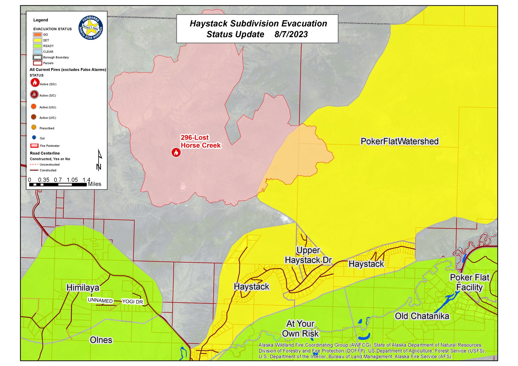
Change in Evacuation Level for Upper Haystack Subdivision from LEVEL 3 GO to LEVEL 2 SET
Related Incident: Lost Horse Creek Fire
Publication Type: Announcement
FAIRBANKS NORTH STAR BOROUGH EMERGENCY OPERATIONS ANNOUNCEMENT
August 7, 2023, 8:00 pm
This notice is for residents and individuals affected by the Lost Horse Creek Fire #296, in the Upper Haystack Subdivision, including Sharmon Court and Middle Fork Road. The evacuation level has been changed from Level 3 (GO) to Level 2 (SET) effective at 8:00 pm AK.
All other roads in Haystack Subdivision remain at Level 2 (SET).
Although conditions are improving in the area, there is still a potential threat, and residents are advised to remain vigilant and be prepared to evacuate if necessary.
To prioritize safety during this situation:
- Stay informed through official channels: FSNB.GOV. AKFIREINFO.COM, FNSB.GOV/AQ
- Have essential supplies available.
- Charge your cell phone and other essential devices.
- Stay connected with family and friends for support and vital information.
- If you are able, offer assistance to those who need it.
- Share updates with those who may not have access to smartphones or the internet.
- In case of changes or new developments with the fires, updates will be provided through various channels including FNSB.GOV, local media outlets, and social media.
- Continued cooperation and preparedness from the public are essential for everyone's safety.
- FNSB Emergency Operations will continue to monitor the fires and provide updates as needed.
If you are not sure of your neighborhood and evacuation status visit: https://bit.ly/3BCKi62
Read Fire News from multiple agencies: https://akfireinfo.com/
Alaska Wildland Fire Information Map Series: https://arcg.is/OSaTe
FNSB Air Quality, Current Smoke and Smoke Prediction: fnsb.gov/aq
OPT-IN for text messages by texting FNSB2023Wildfires to 2 2 6 7 8 7
Two Large Fires Burning on Pagosa Ranger District
Related Incident: Quartz Ridge Fire
Publication Type: News
PAGOSA SPRINGS, Colo., August 7, 2023—Two large fires and several small fires are burning on the Pagosa Ranger District. The two large fires are the Quartz Ridge and Bear Creek. The San Juan Type 3 Incident Management Team (IMT) will be assuming command for both large fires at 6am Tuesday, August 8th. An InciWeb page has been established for both of these incidents for up-to-date information.
The Quartz Ridge Fire, burning approximately three miles into the South San Juan Wilderness, has grown to 558 acres since its discovery August 5th. Its smoke column is very visible from Pagosa Springs and the surrounding area. Firefighters are unable to directly engage the fire due to very steep terrain, its remote location, and firefighter risk associated with working in standing dead and down trees. The Quartz Ridge Fire is expected to remain in a very remote location of the South San Juan Wilderness. Fire managers continue to develop a strategic plan to suppress the fire should it move into terrain more favorable to engagement. In response to fire activity, the Quartz Meadows Road (NFSR#685), the Quartz Ridge Trail (NFST#570) and the Quartz Creek Trail (NFST#571) are closed to the public. The fire will continue to be highly visible to travelers on US Highway 160, Colorado Highway 84, and from the communities of Pagosa Springs, Bayfield, and Durango.
The Bear Creek Fire, burning approximately 2.5 miles West of the Weminuche Valley, has grown to approximately 150 acres since its discovery August 1st. Direct fire suppression efforts occurred the first two operational shifts but due to increased fire behavior and the presence of dead standing trees, firefighters disengaged in accordance with a comprehensive risk analysis. Fire suppression resources remain in the immediate fire area and are actively monitoring fire progression to the northeast. Numerous additional fire resources have been ordered and will join suppression operations in the coming days. The following Forest Service Trails have been closed in response to fire activity: Little Sand Trail (#591) from Mosca Road, Shaw Creek Trail (#584), and Falls Creek Trail (#673). The fire will continue to be visible from the communities of Pagosa Springs, Bayfield, and the surrounding travel corridors of US Highway 160 and Colorado Highway 84.
For information on fire restrictions, current conditions and recreation opportunities on the San Juan National Forest, call (970) 247-4874, visit the forest website, or follow us on Twitter and Facebook.
Fire Update 87
Related Incident: Bear Creek Fire
Publication Type: News
PAGOSA SPRINGS, Colo., August 7, 2023—Two large fires and several small fires are burning on the Pagosa Ranger District. The two large fires are the Quartz Ridge and Bear Creek. The San Juan Type 3 Incident Management Team (IMT) will be assuming command for both large fires at 6am Tuesday, August 8th. An InciWeb page has been established for both of these incidents for up-to-date information.
The Quartz Ridge Fire, burning approximately three miles into the South San Juan Wilderness, has grown to 558 acres since its discovery August 5th. Its smoke column is very visible from Pagosa Springs and the surrounding area. Firefighters are unable to directly engage the fire due to very steep terrain, its remote location, and firefighter risk associated with working in standing dead and down trees. The Quartz Ridge Fire is expected to remain in a very remote location of the South San Juan Wilderness. Fire managers continue to develop a strategic plan to suppress the fire should it move into terrain more favorable to engagement. In response to fire activity, the Quartz Meadows Road (NFSR#685), the Quartz Ridge Trail (NFST#570) and the Quartz Creek Trail (NFST#571) are closed to the public. The fire will continue to be highly visible to travelers on US Highway 160, Colorado Highway 84, and from the communities of Pagosa Springs, Bayfield, and Durango.
The Bear Creek Fire, burning approximately 2.5 miles West of the Weminuche Valley, has grown to approximately 150 acres since its discovery August 1st. Direct fire suppression efforts occurred the first two operational shifts but due to increased fire behavior and the presence of dead standing trees, firefighters disengaged in accordance with a comprehensive risk analysis. Fire suppression resources remain in the immediate fire area and are actively monitoring fire progression to the northeast. Numerous additional fire resources have been ordered and will join suppression operations in the coming days. The following Forest Service Trails have been closed in response to fire activity: Little Sand Trail (#591) from Mosca Road, Shaw Creek Trail (#584), and Falls Creek Trail (#673). The fire will continue to be visible from the communities of Pagosa Springs, Bayfield, and the surrounding travel corridors of US Highway 160 and Colorado Highway 84.
For information on fire restrictions, current conditions and recreation opportunities on the San Juan National Forest, call (970) 247-4874, visit the forest website, or follow us on Twitter and Facebook.
Publication Type: Announcement
TWO UPCOMING COMMUNITY MEETINGS!
Join us for a community meeting regarding the Big Knife, Niarada, and Mill Pocket fires on Wednesday, August 9, 2023, 6:00 PM, at the Elmo Community Center, 47088 Cemetery Road in Elmo. The meeting will broadcast live on the CSKT Facebook page.
There will also be a community meeting regarding the Big Knife, Niarada, and Mill Pocket fires on Thursday, August 10, 2023, 6:00 PM, at the Arlee Community Center, 34086 Pow Wow Road in Arlee. The meeting will broadcast live on the CSKT Facebook page.
Aug 7 2023 Update
Related Incident: American Mesa Fire
Publication Type: News
Despite critical fire weather conditions, crews on the ground and in the air kept growth of the American Mesa Fire at a minimum. The fire is currently 756 acres with 25% containment.
“This fire really wanted to move,” said Jicarilla Ranger District Duty Officer Brent Woffindin. “But our crews worked hard to keep it at bay and it paid off.”
Forecasts call for improved weather on Tuesday, when there is a 30% chance of showers. Temperatures may be cooler with higher humidities and breezy conditions.
A Type 3 Incident Management Team will take over management of the fire Tuesday morning.
The public can continue to follow the American Mesa Fire on InciWeb, New Mexico Fire Information and Carson National Forest social media channels on Facebook and X (formerly Twitter).
Hungry Horse Reservoir Area Closure August 7th 2023
Related Incident:
Publication Type: Announcement
 Hungry Horse Reservoir Closed Due to Fire Activity.
Hungry Horse Reservoir will be closed beginning August 8, 2023. All National Forest System lands in the area and National Forest System roads 38 and 895 will be closed to public use for public and firefighter safety.
FS Road #38 (East Side Road #38) is closed to all public traffic east of the junction of FS Road #497 (Desert Mountain Road) and East Side Road #38. Currently, FS Road #895 (West Side South Fork Road #895) is closed to all public traffic starting at mile 15, near the Lid Creek Campground. Starting tomorrow, West Side South Fork Road #895 will be closed starting from the Hungry Horse Dam Visitor Center. The road will remain open approximately 800 feet south of the west abutment of Hungry Horse Dam to facilitate traffic flow.
Hungry Horse Reservoir Area Closure August 7th 2023
Related Incident:
Publication Type: Closures
Hungry Horse Reservoir Closed Due to Fire Activity
Hungry Horse Reservoir will be closed beginning August 8, 2023. All National Forest System lands in the area and National Forest System roads 38 and 895 will be closed to public use for public and firefighter safety.
FS Road #38 (East Side Road #38) is closed to all public traffic east of the junction of FS Road #497 (Desert Mountain Road) and East Side Road #38. Currently, FS Road #895 (West Side South Fork Road #895) is closed to all public traffic starting at mile 15, near the Lid Creek Campground. Starting tomorrow, West Side South Fork Road #895 will be closed starting from the Hungry Horse Dam Visitor Center. The road will remain open approximately 800 feet south of the west abutment of Hungry Horse Dam to facilitate traffic flow.
Use of Confinement Strategy on Lowline Fire
Related Incident: Lowline Fire
Publication Type: Announcement
Our recent daily updates have mentioned the use of a “confinement strategy” on the remote western side of Lowline Fire (Division X). We’ve put together this short video to help communicate what that means and why we’re doing it. Look for additional information coming tonight and tomorrow on this topic.
Ridge Creek Fire Daily Update for August 7 2023
Related Incident:
Publication Type: News
Ridge Creek Fire
Idaho Panhandle National Forests, Coeur d’Alene River Ranger District
Fire Information 208-953-7022
Media Information 989-292-9373
https://inciweb.nwcg.gov/incident-information/idipf-ridge-creek
August 7, 2023
Location: Approximately 3.5 miles east of the north tip of Hayden Lake, along the Hayden Creek Road (FSR 437) in the Ridge Creek drainage
Start Date: 8/3/2023 Cause: Human/Under Investigation Size: 1,062 acres Containment: 0% Total Personnel: 114 Engines: 6 Heavy Equipment: 5 Crews: 1 Falling Module
On Monday 08/07/23, the Eastern Area Incident Management Team, led by Incident Commander Steve Miller, assumed command of the fire. The Eastern Area team would like to thank the local team for leading the initial response, successful transition, and continued assistance. There have been no changes to evacuation or closure statuses, but that is being continuously evaluated and communicated with Kootenai County Emergency Management.
An infrared flight was scheduled for observation last night but due to cloud cover was unable to be completed, an IR flight is scheduled for this evening. Fire managers will be keeping a close eye on the weather for any wind shifts that accompany the forecasted thunderstorms, but the elevated RH (relative humidity) and possible precipitation could provide some much-needed aid to suppression efforts. At the time of this release, the fire area has received little precipitation from the current weather system.
Yesterday hand crews worked on the south end of the fire along Forrest Service Road 437/Hayden Creek. Mechanical lines were placed yesterday in the area of FSR 428 and road improvements were made on FSR 437. Work in these areas continue today.
EVACUATION STATUS
There have been no changes to the evacuation status since the last update. A message from the Kootenai County Emergency Management: Out of an abundance of caution, residents within the boundary (see attached map) are being provided with a GET READY notification. The Ridge Creek Fire is in your area and it would be wise to consider planning and or packing in the event an evacuation becomes necessary. Residents are urged to create and maintain a defensible space and harden their home against the potential for wildfire. More information will be forthcoming as it becomes available. Please continue to monitor official sources and call 208-446-2292 for any questions regarding evacuations. Follow Kootenai County Emergency Management Facebook Page for updates and sign up for automated Kootenai Alert for emergency alerts. https://www.kcsheriff.com/186/Emergency-Management
CLOSURES AND SPECIAL MESSAGES
Honeysuckle boat launch is open. Firefighting aircraft are still actively engaged on multiple fires in the area and will continue to use area waterways for fire suppression efforts. All lake users should be on the lookout for approaching aircraft and clear the area for emergency firefighting aircraft.
The Idaho Panhandle National Forests issued an emergency closure (Closure Order #01-04-03-23-002) effective August 4, 2023. This Order is for public and firefighter safety due to heavy fire traffic on the area impacted on the Coeur d’Alene River Ranger District, and prohibits all methods of travel (foot, mechanized, motorized and stock) on Forest Service Roads 392, 428A, 437, 1511, 1530, 1552, 1587 and Forest Service Roads 206 and 406 north of their junction, Forest Service Trails 69, 78, 234, and 802 as well as within the described area.
WEATHER AND FIRE BEHAVIOR
A 60% chance of showers and thunderstorms today, mostly cloudy, with a high near 74. Minimum RH is
55 percent. West winds 1 to 3 mph gusting to 6 mph. Gusty erratic winds are expected near the thunderstorms. Precipitation of 0.50 to 1.00 inches is expected through Monday night. A warm drying trend is expected starting Tuesday.