
Settings - change map background and toggle additional layers
Filter - control incident types displayed on map.
Zoom to your location
Reset map zoom and position
Could not determine your location.
Show Legend
 Wildfire
 Prescribed Fire
 Burned Area
Response
Burned Area
Response Other
Other
Bear Creek Fire
Unit Information
Incident Contacts
Hot and Dry Conditions Along With Unforgiving Terrain Challenging Firefighters on Brady Fire
Related Incident:
Publication Type: News
Payson, AZ (8/7/23) – The Department of Forestry and Fire Management DFFM) along with the Tonto National Forest remain in unified command on the Brady Fire and today placed an order for a Type 1 Incident Management Team due to the fire’s complexity and values at risk. The Brady Fire, north of Payson continues to remain active aided by hot, dry, and windy conditions. The fire is active on all sides and is pushing to the north and east and has moved on top of the Mogollon Rim. Aircraft flew the fire this morning as part of aerial reconnaissance and mapped the fire at 285 acres.
Today crews scouted for possible control features along the east and west sides of the fire to be used as part of suppression efforts. Crews are also identifying and assessing possible structures threatened along with values at risk, including watersheds. They are working to keep the fire south of the 300 Road, north of the Control Road which is north of Whispering Pines, east of Webber Creek and west of Washington Park. The fire has stayed very active since it started, driven by terrain and wind as it burns through Ponderosa pine, Pinyon Juniper, and grass and brush within very steep and rugged terrain. On Sunday the fire was spotting and running and access in some areas has been difficult for crews. Weather continues to pose a challenge for firefighters with lingering hot and dry conditions along with potential outflow winds associated with monsoonal buildup to the north and northwest of the fire area. Approximately 122 personnel are assigned to the fire, including engine and hand crews, plus two helicopters, one dozer and a water tender. More resources are on order. The cause of the fire is under investigation.
At this time, SET is in place for two scout camps within the Tonto National Forest; Camp Geronimo and Shadow Ridge Camps. Any additional SET or GO notifications will come from the Gila County Sheriff’s Office. Residents should stay alert and be prepared by having a ‘go bag’ ready with items like important documents, credit cards, photos, prescriptions, snacks and water, and IDs.
The fire started Sunday, August 6, 2023, around 2 pm and approximately 11 miles north of Payson near the Mogollon Rim in Gila County. Crews off the Payson Ranger District and DFFM resources engaged immediately with initial attack. At the time of the initial start, the fire was producing two columns and was pushing to the north and east. Fire officials are working closely with the neighboring Coconino National Forest with possible closure orders going into effect in the fire area within the Coconino and Tonto National Forests.
For more information, contact Tiffany Davila at 602-540-1036 or by email at tdavila@dffm.az.gov
###
Black River Complex Daily Update August 7 2023
Related Incident: Black River Complex
Publication Type: News
CORDUROY FIRE
Start Date: July 12, 2023, Location: 20 Miles SW Alpine, Percent Contained: 10, Size: 596 acres, Cause: Lightning, Vegetation: Timber (Litter and Understory) Medium Logging Slash, Personnel Assigned: 34, Resources Assigned: 5 Engines, 3 Crews, 1 Dozer, 2 Water tenders.
Operations: Fire crews worked on structure protection at Hannagan Meadow yesterday and will continue to prep the property with sprinkler systems. Firefighters will look to tie in and connect dozer and hand lines along the 24 road today.
BOUNDARY FIRE
Start Date: July 27, 2023, Location: 30 Miles SW of Alpine, Percent Contained: 0, Size: 861 acres, Cause: Lightning, Vegetation: Timber (Litter and Understory) Brush (2 feet), Personnel Assigned: 72, Resources Assigned: 1 Crew.
Operations: The fire has crossed onto San Carlos Apache Indian Reservation land. The Boundary fire will continue to be monitored and assessed for potential needs.
WILLOW FIRE
Start Date: July 27, 2023, Location: 12 Miles SW of Alpine, Percent Contained: 0, Size: 401 acres, Cause: Lightning, Vegetation: Timber (Grass and Understory) Medium Logging Slash, Personnel Assigned: 7, Resources Assigned: 3 Crews, 5 Engines, 2 Dozers.
Operations: Firefighters are working to improve and expand control lines on the western flank, prep highway 191, and tie into the Horton fire footprint to the south.
Closures: To provide for public and firefighter safety, highway 191 is temporarily closed in both directions from mileposts 233 to 238. There is no estimated time to reopen the highway.
Weather: Today’s forecast calls for thunderstorms in the afternoon with a 50% chance of precipitation, a high of 79 degrees, and winds 10-15 mph.
Values at risk: Sensitive species in surrounding areas, cattle and grazing areas, watersheds, riparian areas, impacts to Highway 191, Hannagan Lodge, and nearby electric powerlines.
Restrictions: The Apache-Sitgreaves National Forests are in Stage 1 Fire Restrictions. For details, please visit https://www.fs.usda.gov/alerts/ /alerts-notices/?aid=81123.
Smoke: Go to https://fire.airnow.gov/ to see the latest smoke conditions in your community. Smoke may be visible from Hwy 191, especially at night.
Official fire information:
- Inciweb: https://inciweb.wildfire.gov/incident-information/azasf-black-river-complex
- Incident Email and Phone: 2023.blackrivercomplex@firenet.gov, 928-245-1585
- Facebook: https://www.facebook.com/apachesitgreavesnfs
- Apache-Sitgreaves website: https://www.fs.usda.gov/asnf
Settings - change map background and toggle additional layers
Filter - control incident types displayed on map.
Zoom to your location
Reset map zoom and position
Could not determine your location.
Show Legend
- Wildfire
- Prescribed Fire
- Burned Area
Response
- Other
Sidney Fire
Unit Information
Incident Contacts
Quartz Ridge Closure
Related Incident: Quartz Ridge Fire
Publication Type: Closures
The Quartz Meadows Road (NFSR#685), the Quartz Ridge Trail (NFST#570) and the Quartz Creek Trail (NFST#571) are closed to the public.
Additional information can be obtained at: https://www.fs.usda.gov/alerts/sanjuan/alerts-notices
Settings - change map background and toggle additional layers
Filter - control incident types displayed on map.
Zoom to your location
Reset map zoom and position
Could not determine your location.
Show Legend
- Wildfire
- Prescribed Fire
- Burned Area
Response
- Other
Quartz Ridge Fire
Unit Information
Incident Contacts
Gunnison County Emergency Management Press Release August 7 2023
Related Incident: Lowline Fire
Publication Type: Announcement
PRESS RELEASE - Gunnison County Community & Economic Development Department
The Lowline Fire between Gunnison and Crested Butte has reminded us all that wildfire is a real risk in Gunnison County. The U.S. Forest Service, BLM, state agencies and local responders have done a fantastic job responding to the fire and keeping the community updated. We, as community members, have an important role to play in helping firefighting efforts and reducing the risk to firefighters, ourselves, and our property. Nearly all properties in Gunnison County are part of the wildland-urban interface. What does that mean? In simple terms, the wildland-urban interface represents the zone where development meets untamed wilderness, presenting heightened risk of wildfire hazards.
In response to increasing risk from wildfire the Gunnison County Board of Commissioners adopted the “2021 International Wildland Urban Interface Code” in 2022 which identifies standards for defensible space and ignition resistant construction for new structures and development. County Commissioner Jonathan Houck said, “after we’ve seen so much devastating destruction from wildfires in Colorado we felt it was important to get ahead of the risks and begin to change the way we build structures in Gunnison County so that they are able to resist wildfires.”
Land managers including the U.S. Forest Service and the Colorado State Forest Service have increased their work in the past three years to mitigate the impacts of beetle infestations in the County including the 400-acre Wilder-Highlands Mountain Pine Beetle Response project in the Taylor Canyon and Lost Canyon areas to eliminate the infestations in those areas. These proactive measures support a healthier forest and can reduce some wildfire risk. However, the risk of wildfire and destruction of life and property is exacerbated by rural development patterns and the construction of structures that are not fire resistant.
Mike Tarantino, Supervisory Forester of the Colorado State Forest Service Gunnison Field Office explains that “wildfire risk is driven by three important factors: the likelihood of fire occurring based on local conditions; predicted intensity of a wildfire based on vegetation and weather conditions; and the susceptibility of communities, structures and infrastructure to a wildfire.” The Colorado State Forest Service offers programs and resources to not only support vegetation management on public lands but also on private lands—they help to reduce the likelihood of a high severity catastrophic wildfire occurring through fuels management. They also address the susceptibility of communities and structures to wildfire by working with private property owners to develop defensible space and land management plans for their properties. These resources are available at LiveWildfireReady.org.
However, all properties in Gunnison County—even property owners that live within the City of Gunnison, Crested Butte and Mt. Crested Butte--have the opportunity to reduce their own risk and support our community and firefighters. Creating defensible space around your home and structures is a great place to start. Defensible space is an area around your home or structures that creates a buffer of managed vegetation to reduce wildfire threats.
Sean Caffrey of the Crested Butte Fire Protection District explains that “defensible space can be created through tasks that can be accomplished in a weekend such as mowing all tall grasses and vegetation on a property; removing wood piles and combustible materials away from your home and structures; trimming trees that are close to your house and thinning vegetation within ten feet of a structure.” The Colorado State Forest Service and West Region Wildfire Council offer specific programs and support for defensible space and fuels management for private property owners. Their information and other resources are online at: https://gunnisoncounty.org/1005/Wildfire-Info.
Additionally, when considering building a new structure or doing an addition you may be required (in Gunnison County) to utilize ignition resistant exterior materials. “These materials may include noncombustible materials, fire-retardant treated wood, log or heavy timber, class A or 1-hour fire-rated materials” said Crystal Lambert, Gunnison County Building and Environmental Health Official. Lambert said there are a large number of material options that homeowners can use that will reduce the risk of wildfire damaging their homes or structures and encourages residents to talk with a design professional and local suppliers.
Hugo Ferchau, Gunnison Fire Marshal, says that another important measure that residents should implement is creating a “hardened zone” within five feet of their home and structures. This is an area of five feet surrounding the structure that does not include any flammable materials or vegetation and is maintained to resist wildfire. This can include an area that replaces mulch beds with gravel or replaces a combustible wood deck with a non-combustible or class A-rated material. Significant research has found that structures are most often damaged through the carrying of fire embers on wind—these embers can carry miles and when they land in a mulch bed or on a wood deck they can catch fire and damage or destroy homes.
Wildfire always has been, and always will be part of the landscape in Gunnison County. We’ve been fortunate in that there have not been catastrophic fires here in the past, but looking to the future, we should expect an increase in wildfire frequency and severity. Gunnison County residents have been incredibly supportive of the Lowline Fire firefighting efforts and they can further support those efforts by creating defensible space on their property and using non-combustible materials when building. More information can be found online at: https://gunnisoncounty.org/1005/Wildfire-Info/.
###
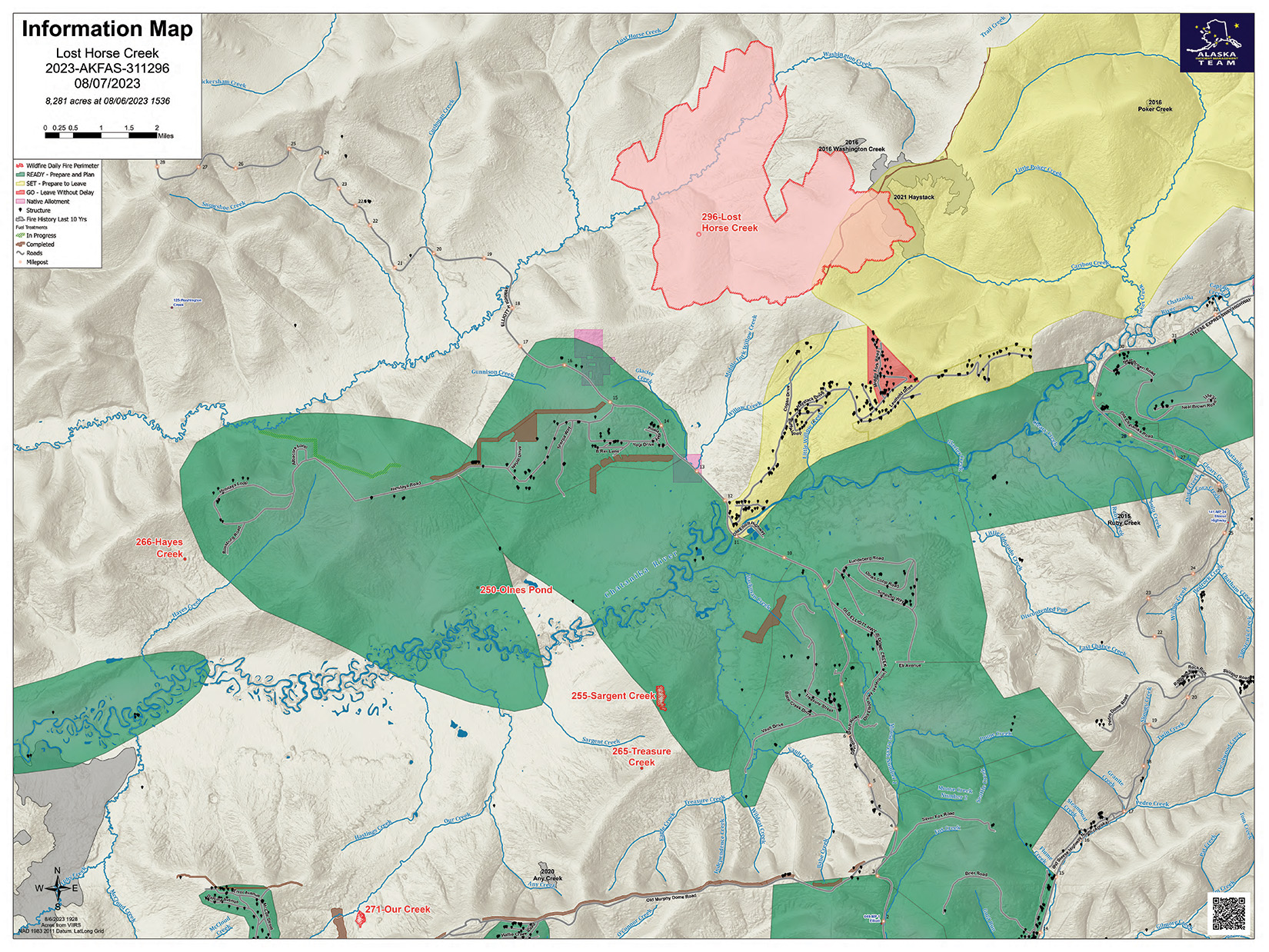
Lost Horse Creek Fire Update Monday August 7 2023
Related Incident: Lost Horse Creek Fire
Publication Type: News
Lost Horse Creek Fire Update
August 7, 2023
Incident Commander: Peter Butteri
Start Date: July 28, 2023
Location: 22 miles N of Fairbanks, AK
Cause: Lightning/Natural
Fire Size: 8,281 acres
Containment: 0%
Total Personnel: 169
(Fairbanks, AK) – Firefighters on the Lost Horse Creek Fire (#296) continue to extend the control line along the southern edge and are scouting the best locations for contingency lines. Structure assessment and protection was completed along Sharmon Court and fuels reduction and structure protection is in progress on Middle Fork Road. Structure protection in the White Mountains National Recreation Area has been completed on the Moose Creek cabin and Lee’s cabin, Eleazar’s cabin is being monitored (see closure section below).
The heavy smoke layer kept air stable during the Red Flag conditions yesterday. Today there is a possibility of thunderstorms with light west-southwest winds. Cooler temperatures and cloud cover is expected early this week.
The Alaska Team is managing six additional fires: the Sargent Creek Fire (#255), Our Creek Fire (#271), Murphy Creek Fire (#320), Treasure Creek (#265), Olnes Pond (#250), and Hayes Creek (#266). These fires are currently in stages of mop up and monitoring and are expected to be contained by the end of the week.
COMMUNITY MEETING: Please join us for a community meeting on Tuesday, August 8 at 6:30 pm at the Haystack Mountain Laundry and Showers parking lot (5001 Haystack Drive). The meeting will be in person and posted on Facebook.
EVACUATIONS: The “GO” level evacuation notice issued by the Fairbanks North Star Borough (Find My Neighborhood (arcgis.com) remains in effect for Upper Haystack Drive, including Sharmon Court and all of Middle Fork Road in the Haystack subdivision.
CLOSURES: Alaska State Parks has closed the Olnes Pond campground to support fire operations. The Bureau of Land Management, Eastern Interior Field Office issued an evacuation and closure order for the western portion of the White Mountains National Recreation Area effective midnight on August 6 until September 1, unless modified. The evacuation and closure includes trails, public use cabins, trail shelters, and the Wickersham Dome Trailhead near Elliott Highway mile 28, which may be used by firefighters. See: Alaska Fire Restrictions | Bureau of Land Management (blm.gov)
AIR QUALITY ADVISORY: With active fires in Interior Alaska, smoke remains a concern for Delta Junction, Nenana, Fairbanks, Livengood, Central, and the surrounding area. Be aware of conditions and limit your exposure. For smoke forecast and air quality measures, see the Fairbanks North Star Borough air quality map (FNSB Air Quality Monitor (arcgis.com).
TEMPORARY FLIGHT RESTRICTIONS (TFR) are in effect until September 1, 2023. For details, see: 3/6714 NOTAM Details (faa.gov)
Public Information: (907) 921- 2555
Media Inquiries: (907) 921- 2554
Email: 2023.LostHorseCreek@firenet.gov
You Tube: Lost Horse Creek Fire #296 - YouTube
www.akfireinfo.com ♦ www.facebook.com/AK.Forestry ♦ tinyurl.com/LostHorseCreekInciweb
Sourdough Fire Update August 7 2023
Related Incident:
Publication Type: News
Resources: 340 Total Personnel | 6 Hand Crews | 22 Engines | 5 Water Tenders | 4 Helicopters
(Newhalem, Wash.) -- The Sourdough Fire started with a lightning strike on July 29 near Diablo in the steep and rugged terrain of the Ross Lake Recreation Area, 7 miles northeast of Newhalem. An estimated 1,440 acres have burned. Due to hazards presented by the fire, State Route 20 (North Cascades Highway) has been closed until further notice between Mile Marker 120 and Mile Marker 156. Northwest Incident Management Team 10 (NW Team 10), managed by Incident Commander Alan Lawson, took command of the fire at 6 a.m. today, bringing additional resources and capacity to the Sourdough Fire. Members of the incoming team spent the day with the Southern Area Incident Management Team, gathering information, assessing and surveying the fire area. The safety of firefighters and the public are the top priority on the Sourdough Fire.
Yesterday: Helicopters played an integral role due to the remote and difficult location of the fire by delivering equipment to crews in areas not served by roads and making bucket drops on the fire’s most active areas. Crews had to be transported by boat to the Ross Lake Resort where efforts to prepare the structures there as well as at the Environmental Learning Center are on-going. In and around Diablo, crews patrolled the area and mopped-up hot spots. Along State Route 20 and under the transmission lines running from Diablo Dam, firefighters continued removing vegetation to strengthen these features as fuel breaks. Fire behavior was light during the morning hours but as the inversion lifted and strong winds increased in the afternoon, moderate fire activity was observed on the west side of Stetattle Creek.
Today: Steep slopes, rolling debris and fire-weakened trees around most of the fire area pose serious hazards to firefighters, inhibiting their efforts to attack the fire directly. Crews will continue to focus on protecting values at risk such as buildings and infrastructure while utilizing aviation resources to check the fire’s spread. Firefighters will continue clearing brush along Highway 20 and the powerline easement. In a process known as plumbing, crews will install hose lays around the Environmental Learning Center, Buster Brown Campground and Ross Lake Resort. These measures provide water supplies for protective sprinkler systems and mop-up in the event of the fire’s spread. Helicopters will be available for bucket drops as necessary.
Weather: A chance of thunderstorms on Monday includes the potential for erratic winds, but little moisture is expected over the fire area. Relative humidity will be slightly higher and temperatures lower.
Smoke: Smoke from the Sourdough Fire may affect communities around the region. Find information about current conditions and a smoke forecast at https://wasmoke.blogspot.com.
Closures and Evacuations: Evacuations are in effect for the North Cascades Environmental Learning Center and the community of Diablo. There is no access to Diablo Dam until further notice. State Route 20 is closed from Newhalem to Rainy Pass. Trail, area and camp closures are in effect; for more information, go to: https://www.nps.gov/noca/planyourvisit/fire-closures.htm
7 de Agosto 2023 Reporte Informe del incendio Flat
Related Incident: Flat Fire
Publication Type: News
This is the Spanish-language update. Some operational words may not translate well.
![]()
![]()
![]()
![]()
7 de agosto, 2023
Reporte para el día de hoy del Incendio Flat
Extensión: 33,266 acres
Inicio:15-Julio-2023
Origen: 2 millas sureste de Agness, OR
Contención: 39%
Personal: 795
Recursos: 22 máquinas de bomberos l 14 cuadrillas de bomberos l 2 buldócer l 29 cisternas l 6 máquinas masticadoras l 9 helicópteros
Resumen: Se está quemando material de combustión de pequeño tamaño. Mientras tanto la materia de mayor tamaño todavía tiene un contenido alto de humedad, limitando la posibilidad de que el incendio se propague y encienda otra masa de material inflamable. Para los próximos días, se experimentarán temperaturas ligeramente frías y porcentajes de humedad más altos, obstaculizando el crecimiento del incendio. Los bomberos se encuentran alertas para cualquier cambio potencial en la actividad del incendio.
Actividades para el día de hoy: Los bomberos siguen asegurando e improvisando las líneas existentes de contención con el objetivo de mantener el fuego en el mismo sitio. Se prosigue con las actividades evaluaciones contantes para todas las divisiones. En las localidades alrededor de Agness, las estructuras de protección continúan evaluando la zona afectada. Los bomberos prosiguen mejorando las líneas de control alternativas sobre el sistema de las Carreteras Forestales (FSR) 1376 (hacia el Sur) y 1503, 3313, así como 3680 (hacia el Oeste). Además, están removiendo material de combustión constituido por los árboles sin vida y derribados por el incendio. Los trabajadores del turno nocturno se dedican a mantener y evaluar las líneas de contención. En caso de ser necesario, los bomberos se encuentran preparados para responder a cualquier inicio de incendio en el área.
Debido a la incrementación del tráfico por la presencia de los bomberos, se hace un llamado a los motoristas cruzando la carretera Bear Camp Road, que manejen con cautela, a baja velocidad y con las luces delanteras del vehículo encendidas.
Condiciones climáticas: La temperatura se enfriará de 2 a 4 grados, permaneciendo entre los 80 y 90, con un porcentaje de humedad relativa de 30 a 40. El viento continuara sobre el terreno moviéndose hacia las cimas y los valles, observándose vientos Noreste en la mañana y vientos Noroeste por la tarde.
Impacto del humo: Se podrá observar la presencia del humo desde las áreas aledañas al incendio. Pronósticos acerca del humo, puede encontrarse en la página web: https://outlooks.wildlandfiresmoke.net/outlook/b74901f7?
Cierres de áreas: El Bosque Nacional de Rogue River-Siskiyou, emitió una orden de cierre incluyendo senderos, carreteras y parte del rio Illinois. Esta orden de cierre abarca Oak Flat Campground, Game Lake Campground, Wildhorse Campground y el Lookout Recreacional de Snow Camp. La carretera forestal de Chetco River Road (FR 1376) y la de Chetco/Pistol River Road (FR 1407) actualmente se encuentran cerradas. Esta nueva orden de cierre permitirá al público el acceso a el área para nadar de Big Rock en el Rio Illinois.
Evacuaciones: Todos los niveles de evacuación han sido reducidos a un Nivel 1 “Prepárese” para todas las áreas en las proximidades del Incendio Flat. https://tinyurl.com/currycountyem
Orden de restricción: Actualmente, el Nivel de Peligro de Incendio es “Extremo”. El Bosque Nacional de Rogue River-Siskiyou ha dictado un Nivel 2 de restricción para el público en general. Para más información: https://tinyurl.com/ueuznr6e
Por favor siga todas las restricciones en el área para prevenir incendios forestales. Conozca el área de recreación antes de visitarla. Revise las restricciones en el uso de fogatas que existen en su destino de recreación.
Linea Informativa:(541)216-4579 Noticieros: (541)237-6369 Email: 2023.flat.or@firenet.gov
Facebook: facebook.com/flatfireoregon2023 Twitter: twitter.com/FlatFireOR2023 Inciweb: bit.ly/FlatFireOR