
Little Mesa Fire Update August 9 2023
Related Incident: Little Mesa Fire
Publication Type: News
Little Mesa Fire Update
Wednesday, August 9, 2023
Location: Approx. 15 miles west, southwest of Delta, CO, Dominguez Escalante National Conservation Area
Jurisdiction: Bureau of Land Management Discovered: July 31, 2023, 11:00 AM
Cause: Lightning Estimated Size: 359-acre
Vegetation Type: Pinyon pine, Juniper, sagebrush, Containment: 0%
and grass
Full Suppression Fire Total Personnel: 65
NOTICE TO THE PUBLIC: Air operations are being conducted on the Little Mesa Fire. For your safety, please stay out of the Pothole Recreation Area. The helicopters will be using this water source to dip water from the potholes for fire suppression.
Current Situation: Last night the Little Mesa Fire was transferred to a Type 3 organization that will assume command of the fire. The fire is estimated at 359 acres by the Colorado Division of Fire Prevention and Control Multi-mission Aircraft infrared flight last night. Yesterday, firefighters prepped values at risk in the fire area and were able to hold the fire at natural barriers. The fire spotted across the little canyon and pushed up towards Dry Mesa Road, but no holding concerns once fire reached the sagebrush and slowed fire behavior.
Today, firefighters on the west side will hold fire along the Tatum Ridge Road to keep fire from going into Escalante Canyon. If weather conditions allow, firefighters will burn vegetation along their indirect lines to secure any up drainage runs that would impact indirect lines or Escalante Canyon. The firefighters on the east side will patrol Dry Mesa Road and continue prep on values at risk, Dry Mesa Guzzler and two historical round pins. They will scout further to the east along Black Ridge to Black Point.
Weather today should bring cooler temperatures and lighter winds that will decrease critical fire weather conditions. There is a change in weather starting on Thursday that may lead to increase in moisture and thunderstorms which could bring frequent lightning and gusty outflow winds each afternoon/evening through the weekend.
Evacuations and Closures: No evacuations have been issued. Temporary road closures in Delta County on Dry Mesa Road at the intersection with Escalante Rim Road in Escalante Canyon and on USFS Dry Mesa Road at Sawmill Mesa Road junction.
Smoke: Smoke is visible from surrounding areas and Highways 50, 550, 92, 65, 141 and C37 Road. Go to https://fire.airnow.gov to get updated smoke conditions in North America.
Aviation Safety: Aircraft may be used over the Little Mesa Fire air space. Fire aviation resources are flying at different altitudes and speeds. Pilots should exercise caution when flying near wildfires to keep everyone safe. Unmanned aircraft systems (UAS) or drones must never fly near wildfires, as UAS are difficult to see and drone pilots have no way of communicating with firefighting aircraft. The only UAS or drones able to fly are agency owned and operated and have been assigned to work on the wildfire and have communication with air operations. Remember if you fly, we can’t!
For updated information follow on these outlets:
Inciweb: https://inciweb.wildfire.gov/incident-information/coupd-little-mesa-fire
Facebook: @BLMMontroseFireUnit Twitter: @SWD_Fire
Bedrock and Salmon Fires Daily Update August 9 2023
Related Incident: Bedrock Fire
Publication Type: News
Bedrock and Salmon Fires
August 9, 2023
Daily Fire Update
Bedrock Fire Quick Facts
Size: 14,264 acres Origin: Willamette National Forest Resources: 38 engines;
Containment: 5% Cause: Under Investigation 15 crews; *9 helicopters;
Total personnel: 809 Start Date: July 22, 2023 14 dozers, 28 water tenders
Salmon Fire Quick Facts
Size: 102 acres Origin: Willamette National Forest Resources: 7 engines;
Containment: 0% Cause: Under Investigation 6 crews; 1 water tender;
Total personnel: 160 Start Date: August 6, 2023 *helicopters shared
Community Meeting: There will be a virtual community meeting tonight at 6 PM on the Bedrock Fire Facebook page at https://www.facebook.com/BedrockFire2023/. Questions about the Salmon and Bedrock Fires can be submitted via Facebook prior to the meeting on the event page.
Bedrock Fire: Firefighters on the north end of the fire near Pernot Mountain began tactical firing operations late yesterday to strengthen and add depth to control lines. Fire crews patrolled these burnout areas overnight, holding and improving lines where needed. Helicopters from the Bedrock Fire flew on the Bedrock, Salmon, Lookout, and Wiley Fires yesterday, cooling the fires with water bucket drops.
Salmon Fire: Firefighters on the ground supported by aviation made good progress yesterday on the Salmon Fire. There were two “slopover” areas on the eastern and western flanks of the fire yesterday. Firefighters quickly began to construct firelines around these new areas of fire growth. Fire crews will be working today to construct hoselays around the fire perimeter to secure and mop up the fire.
Evacuations: The Lane County Sheriff's Office issued a Level 1 “Be Ready” evacuation notice Monday morning for areas north and east of Oakridge because of the Salmon Fire. Please heed all evacuation notices and orders. A searchable evacuation map with fire perimeters for both fires is available at https://lcgisorg.maps.arcgis.com/apps/webappviewer/index.html?id=32e4cd9a5c3348cd81254e6fa394e097. This online map has a ruler tool so the distance from the fires to various towns can be measured.
Smoke: Smoke from the Salmon, Bedrock, Lookout, and Wiley fires in the area will continue to impact air quality. Oakridge and east along Highway 58 is expected to have smoke in the morning until mid-afternoon up to unhealthy conditions until clearing later in the day. The McKenzie Highway corridor will likely have smoke at times with good to moderate conditions.
Weather: Overnight a weak cold front passed to the north of the Bedrock Fire area, bringing some clouds and slightly lower temperatures. Clouds will dissipate before noon, beginning a warming and drying trend. Winds will remain 3-8 miles per hour, with gusts in the afternoon up to 15 miles per hour.
Safety and Closures: The Willamette National Forest implemented the Bedrock Fire Emergency Area Closure on July 24, 2023 to ensure the safety of the public and personnel working on the fire. An emergency closure order for the Salmon Fire area is in place as of August 8. The closure maps for the Bedrock and Salmon Fires are available on InciWeb. There are Temporary Flight Restrictions over the Bedrock and Salmon Fire areas.
Inciweb Salmon: https://inciweb.wildfire.gov/incident-information/orwif-salmon-fire
Inciweb Bedrock:
https://inciweb.nwcg.gov/incident-information/orwif-bedrock-fire
Facebook: https://www.facebook.com/BedrockFire2023/
Fire Information: (541) 414-6272, 8:00 AM – 8:00 PM Email: 2023.bedrock@firenet.gov
Fire Update August 10th
Related Incident: Bear Creek Fire
Publication Type: News
FIRE UPDATE:
Fire start date: August 1, 2023
Fire size today: 330 acres
Containment: 0%
Location: 23 miles Northwest of Pagosa Springs, Colorado
Personnel: 103
Cause: Lightning
Management: Suppression
EVACUATION INFORMATION:
Weminuche Valley is under pre-evacuation notice. Local residents should follow incident information and updates.
CLOSURES:
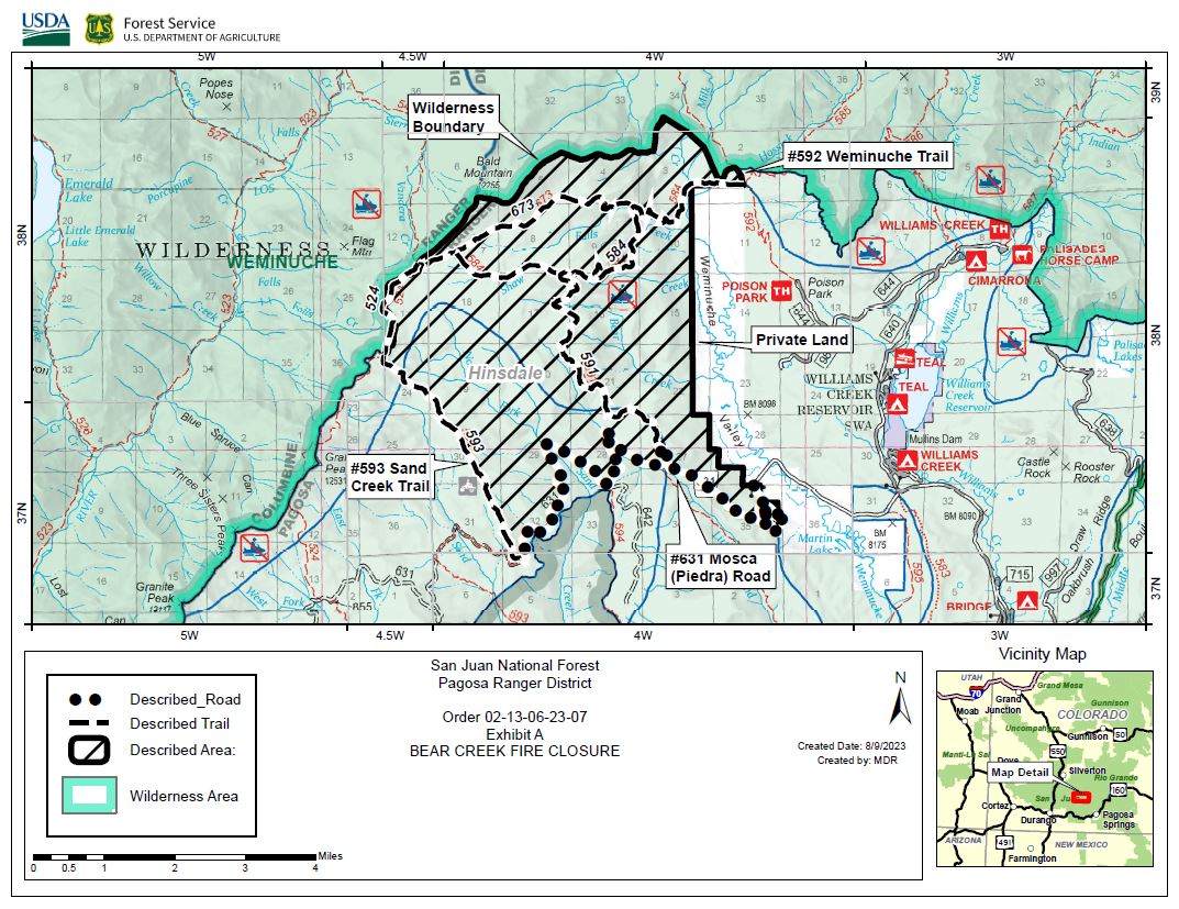
The San Juan National Forest has issued a Closure Order for the area surrounding the Bear Creek Fire. Reference the map included with this update. This Order shall be in effect from August 9, 2023 at 12:00pm through December 31, 2023 at 5:00pm, unless rescinded. The purpose of the order is to protect public health and safety during the ongoing Bear Creek Fire.
• Little Sand Trail (NFST#591) from Mosca Road
• Shaw Creek Trail (NFST#584)
• Falls Creek Trail (NFST#673)
• Cloman Park in Pagosa Springs
Latest Smoke Outlook:
outlooks.wildlandfiresmoke.net/outlook/933fc4e4
INCIDENT OBJECTIVES:
• Firefighter and Public safety will be the highest priority throughout all phases of the incident.
• To protect private lands within the Weminuche Creek drainages, critical infrastructure including powerlines and gas utility lines, as well as natural resources, cultural and historic sites, and recreation assets.
Fire managers continue to develop plans for when the fire reaches terrain more favorable for engagement. Firefighters have been unable to directly engage due the dangerous loading of dead timber both standing and down. Firefighters are prepared for when the fire backs down to the Weminuche Valley, providing an anchor point for them to begin suppression operations. Structure protection operations are underway and will continue today. Crews will monitor the fire overnight. A National Incident Management Organization Team has been ordered to assume command of the incident August 12th at 0600, providing additional capacity and oversight.
YESTERDAY’S ACCOMPLISHMENTS:
• Firefighting crews in the Weminuche Valley area assessed risk level to private land/structures and developed and began implementing structure protection plans. Residences closest to the fire have been completed. Ground crews are continuing assessments heading south through the valley.
• Local ground fire resources continued to directly monitor fire growth and directional spread. These observations are critical to assessing the probability of success of the current incident strategy being achieved.
TODAY’S PLAN:
• Structure protection groups will continue risk assessments and will set up structure protection equipment.
• Operational overhead will continue scouting indirect control opportunities to the south along the Mosca Road, connecting that east into the Weminuche Valley.
• Incoming firefighting resources will be briefed and assigned operational assignments. Significant national competition for resources on higher-priority fires has led to difficulty in obtaining the number/types of resources needed.
• Continue to collaboratively develop Management Action Points (MAP) with cooperators and stakeholders. MAPs are clearly specified incident conditions that, when reached, prompt a predefined fire management action or trigger the implementation of new strategies/tactics.
• Communicate with landowners, affected utilities, and county stakeholders.
WEATHER:
The weather trend includes increasing chances of rain showers. Lower temperatures and higher humidities are expected, as are scattered showers and thunderstorms.
Bedrock and Salmon Fires Daily Update August 9 2023
Related Incident: Salmon Fire
Publication Type: News
Bedrock and Salmon Fires
August 9, 2023
Daily Fire Update
Bedrock Fire Quick Facts
Size: 14,264 acres Origin: Willamette National Forest Resources: 38 engines;
Containment: 5% Cause: Under Investigation 15 crews; *9 helicopters;
Total personnel: 809 Start Date: July 22, 2023 14 dozers, 28 water tenders
Salmon Fire Quick Facts
Size: 102 acres Origin: Willamette National Forest Resources: 7 engines;
Containment: 0% Cause: Under Investigation 6 crews; 1 water tender;
Total personnel: 160 Start Date: August 6, 2023 *helicopters shared
Community Meeting: There will be a virtual community meeting tonight at 6 PM on the Bedrock Fire Facebook page at https://www.facebook.com/BedrockFire2023/. Questions about the Salmon and Bedrock Fires can be submitted via Facebook prior to the meeting on the event page.
Bedrock Fire: Firefighters on the north end of the fire near Pernot Mountain began tactical firing operations late yesterday to strengthen and add depth to control lines. Fire crews patrolled these burnout areas overnight, holding and improving lines where needed. Helicopters from the Bedrock Fire flew on the Bedrock, Salmon, Lookout, and Wiley Fires yesterday, cooling the fires with water bucket drops.
Salmon Fire: Firefighters on the ground supported by aviation made good progress yesterday on the Salmon Fire. There were two “slopover” areas on the eastern and western flanks of the fire yesterday. Firefighters quickly began to construct firelines around these new areas of fire growth. Fire crews will be working today to construct hoselays around the fire perimeter to secure and mop up the fire.
Evacuations: The Lane County Sheriff's Office issued a Level 1 “Be Ready” evacuation notice Monday morning for areas north and east of Oakridge because of the Salmon Fire. Please heed all evacuation notices and orders. A searchable evacuation map with fire perimeters for both fires is available at https://lcgisorg.maps.arcgis.com/apps/webappviewer/index.html?id=32e4cd9a5c3348cd81254e6fa394e097. This online map has a ruler tool so the distance from the fires to various towns can be measured.
Smoke: Smoke from the Salmon, Bedrock, Lookout, and Wiley fires in the area will continue to impact air quality. Oakridge and east along Highway 58 is expected to have smoke in the morning until mid-afternoon up to unhealthy conditions until clearing later in the day. The McKenzie Highway corridor will likely have smoke at times with good to moderate conditions.
Weather: Overnight a weak cold front passed to the north of the Bedrock Fire area, bringing some clouds and slightly lower temperatures. Clouds will dissipate before noon, beginning a warming and drying trend. Winds will remain 3-8 miles per hour, with gusts in the afternoon up to 15 miles per hour.
Safety and Closures: The Willamette National Forest implemented the Bedrock Fire Emergency Area Closure on July 24, 2023 to ensure the safety of the public and personnel working on the fire. An emergency closure order for the Salmon Fire area is in place as of August 8. The closure maps for the Bedrock and Salmon Fires are available on InciWeb. There are Temporary Flight Restrictions over the Bedrock and Salmon Fire areas.
Inciweb Salmon: https://inciweb.wildfire.gov/incident-information/orwif-salmon-fire
Inciweb Bedrock:
https://inciweb.nwcg.gov/incident-information/orwif-bedrock-fire
Facebook: https://www.facebook.com/BedrockFire2023/
Fire Information: (541) 414-6272, 8:00 AM – 8:00 PM Email: 2023.bedrock@firenet.gov
Perspectiva de Humo 9 de Agosto 2023
Related Incident: Lowline Fire
Publication Type: News
Aviso Especial
ALERTA CONDICIONES METEOROLÓGICAS CRÍTICAS DE INCENDIOS: AVISO DE BANDERA ROJA CON VIENTOS HOY. Vientos del Oeste de 10-15 mph aumentando a 15-20 mph en la tarde, con ráfagas de hasta 30mph.
Fuego
El fuego Lowline se encuentra en 1,871 acres y está contenido 55%.
Humo
Veremos las mismas tendencias con impactos de humo en la zona hoy. El humo local incluye una ligera bruma. El humo en el valle, en áreas de Gunnison, y el centro del condado de Gunnison continúa hasta las primeras horas de la mañana, con un impacto de humo MODERADO. El humo se disipará para el mediodía con el aumento de los vientos del oeste en la zona. En el área de Castleton Ranch, a lo largo de la carretera del condado #730, seguirán produciéndose períodos de humo MODERADO. Los impactos de humo ligero en las áreas cercanas a Almont y la autopista 135 se disiparán a primera hora de la mañana, ya que los vientos del oeste empujan el humo hacia el este. Crested Butte seguirá teniendo una BUENA calidad de aire durante todo el día.
Alerta de calidad del aire
Aviso de salud sobre la calidad del aire por el humo de los incendios forestales Emitido para el centro del condado de Gunnison
Flat Fire Update 08092023
Related Incident: Flat Fire
Publication Type: News
August 9, 2023
Flat Fire Morning Update
Size: 33,811 acres
Start Date: July 15, 2023
Point of origin: 2 miles southeast of Agness, OR
Containment: 39%
Total personnel: 812
Resources: 20 engines l 23 crews l 4 bulldozers l 27 water tenders l 9 masticators l 7 helicopters
Highlights: Helicopters conducted more water drops yesterday to fire to reduce fire activity. Smaller fuels are burning, but brush is still slow to ignite, which limits the ability of the fire to spread. Today and tomorrow will be cooler with slightly higher humidities before temperatures rise over the weekend. Firefighters remain ready for any potential changes in fire activity.
Today’s Activities: Crews are beginning soil stabilization work in areas impacted by the fire and fire suppression activities. Smoke may be seen from hotspots in the southwestern portion of the fire – the hotspots are well within the containment line. Fire crews continue to assess and improve existing and alternate containment lines. Structural protection resources remain on duty in the Agness area. Firefighters are ready to respond if there are any changes in the fire.
All motorists are asked to use caution when driving in the fire area – please slow down, use headlights, and watch for oncoming traffic.
Weather: Temperatures will be slightly cooler with moist conditions over the fire area. Winds will be similar to yesterday with a west-northwesterly flow in the afternoon. Thursday’s weather is expected to be almost a repeat of today. Higher temperatures and lower humidity will begin moving in Friday.
Smoke: Smoke may be visible from the surrounding areas. The Smoke Outlook is available at: https://outlooks.wildlandfiresmoke.net/outlook/b74901f7?
Closures: The Rogue River-Siskiyou National Forest (RRSNF) has issued a closure order for the fire area including trails, roads and a portion of the Illinois River. Oak Flat Campground, Game Lake and Wild Horse Campgrounds and Snow Camp Lookout Recreation Rentals are all closed. The Chetco River Road (FSR 1376) and Chetco/Pistol River Road (FSR 1407) are closed. The closure allows for public access to the Big Rock swimming hole on the Illinois River.
Evacuations: Level 1 “Get Ready” evacuation status in place for areas in the vicinity of the Flat Fire. Link to
more information: https://tinyurl.com/currycountyem
Restrictions: Fire danger is currently extreme; the RRSNF is implementing Level 2 Public Use Restrictions. More information here: https://tinyurl.com/ueuznr6e
Please follow all fire restrictions to prevent wildfires. Know before you go. Check on whether there are any campfire restrictions at your recreation destination.
Fire Information:(541)216-4579 Media inquiries: (541)237-6369 Email: 2023.flat.or@firenet.gov
Facebook: facebook.com/flatfireoregon2023 Twitter: twitter.com/FlatFireOR2023 Inciweb: bit.ly/FlatFireOR
Publication Type: News
Big Knife, Niarada, & Mill Pocket Fires
Daily Update August 9, 2023
Confederated Salish and Kootenai Tribes
Fire Information: 406-426-9595 | 2023.BigKnife@firenet.gov
https://tinyurl.com/BigKnifeFire https://tinyurl.com/NiaradaMillPocketFires
Location: Big Knife - 5 miles east of Arlee, MT | Niarada - 12 miles west of Elmo, MT | Mill Pocket: 3 miles West of Hwy. 28
Start Date: Big Knife - 7/24/2023 | Niarada - 7/30/2023 | Mill Pocket – 7/30/2023 Cause: Lightning Structures Lost: 4
Big Knife-4,864 acres, 5% contained | Niarada–20,365 acres, 25% contained | Mill Pocket– 2,135 acres, 51% contained
Total Personnel: 666 total Engines: 50 Aircraft: 1 + others available as needed Hand Crews: 12
Community meeting TONIGHT!
Please join us tonight, Wednesday, August 9, at the Elmo Community Center at 6 PM for a public meeting. We will hold a second public meeting tomorrow, Thursday, August 10, at the Arlee Community Center at 6 PM. Both meetings will be live-streamed via the CSKT Division of Fire Facebook page, and we will provide status updates for all three fires.
Big Knife Fire
Although fuels in upper elevations are still quite wet, lower elevations and exposed aspects around the Big Knife Fire are drying out following recent precipitation. Heavy equipment operators continue working to tie existing road prisms into constructed firelines along the fire’s southwestern perimeter. Additional crews and engines arrived Tuesday to help complete point protection measures and mulch vegetation along Jocko Canyon and Canal roads, should firing operations become necessary to hold the fire south of Jocko River. Firefighters continued improving and mopping up the edge of a strategic firing operation they conducted late last week to keep the fire north of Agency Creek. Aircraft are aiding firefighters as conditions allow. Resource Advisors are working with fire managers to ensure cultural and natural resource values are evaluated and protected during suppression activities.
Niarada Fire & Mill Pocket Fire
Firefighters continue to improve firelines around the perimeter of the Niarada Fire. Crews are cooling the fire's edge (mop-up) along Cromwell Creek Road and assessing pockets of unburned fuels west of that line to evaluate whether they pose concerns for containment. Heavy fuels and steep terrain continue hampering efforts along the fire's eastern and southeastern edge; however, crews and equipment operators have constructed initial firelines around much of that perimeter. Firefighters will likely need to perform firing operations to secure portions of the indirect line. Still, those operations will need to be conducted when conditions are right. Firefighters will continue to rely on aircraft to cool hotspots and heavy fuels to slow fire spread and make direct line construction feasible. Structure protection crews continue to work outside Elmo towards Big Arm, and a night shift helps keep watch over changing conditions and fire behavior.
Yesterday a type 1 helicopter conducting water drops helped firefighters working Mill Pocket Fire cool the northwest side where heat remains in treacherous scree slopes. Firefighters will continue to mop up and monitor the fire's edge.
WEATHER AND FIRE BEHAVIOR
A dry front approaching western Montana is expected to bring west to northwest winds Wednesday through Thursday, gusting 25-30 miles per hour. Meteorologists forecast warmer temperatures with highs in the 80s. By mid-week, small, medium, and heavy fuels will likely be dried out sufficiently to result in active fire behavior once again.
CLOSURES AND SPECIAL MESSAGES
The Lake County Sheriff has placed several areas near the base of the mountains west of the Big Knife Fire in PRE-EVACUATION status. See the map for those locations in yellow (Jocko, Canal, Francis). In the Tribal Primitive Area, Belmore Slough and Burnt Cabin Roads are closed.
The Lake County Sheriff’s Office is downgrading those in EVACUATION status near the Niarada Fire in Lake County to a PRE-EVACUATION WARNING. This area includes Alexander Road, Early Dawn Road, Spring Lane Road, Walking Horse Lane, Windward Heights Road, Wildhorse View, Buffalo Bridge Road, Saddle Drive, Island Butte Lane, Bridle Path, Ten Deuce Way, Cliffview Drive, and Ricketts Road.
A PRE-EVACUATION WARNING means you may return to your home. However, as there is still a potential threat from the Niarada Fire, please do not bring back evacuated livestock until the area is downgraded to READY status. The remainder of the town of Elmo is in READY status.
A temporary flight restriction (TFR) is in effect around both fire areas. Do not fly unmanned aircraft (drones) near the fire areas, as that is hazardous for pilots, and the firefighters on the ground who rely on aircraft support. Remember, if you fly, we can’t!
Use extreme caution when driving on Highway 28. Although authorities have removed the modified speed limit on Highway 28, firefighters and equipment are still working in the area.
FIRE RESTRICTIONS
Stage 2 fire restrictions are in place across the Flathead Indian Reservation. No campfires are allowed, no smoking outside of vehicles, no operating combustible engines between 1PM-1AM, no operating vehicles off designated roads and trails. Residents and visitors are encouraged to visit www.MTFireInfo.org for more fire information across Montana.
Lowline Fire Public Information Map August 9 2023
Related Incident: Lowline Fire
Publication Type: News
Lowline Fire Update Wednesday August 9 2023
Related Incident: Lowline Fire
Publication Type: News
Lowline Fire Update
Wednesday, August 9, 2023 – 9:00 a.m.
Type 3 Incident Management
Bryan Gaines, Incident Commander
Information Phone: 970-648-4470 (public), 970-765-7123 (media)
Email: 2023.lowline@firenet.gov
Information Staffing Hours: 8 a.m. to 8 p.m.
Special Note: Today at 6:00 a.m. the Type 3 Incident Management Team assumed command of the Lowline Fire. Incident Commander Bryan Gaines commended the Rocky Mountain Complex Incident Management Team for their quality work and smooth transition.
Current Situation: We had a successful transition from the Rocky Mountain Complex Incident Management Team and the Type 3 Incident Management Team. Red Flag conditions persisted over the Lowline Fire area, which resulted in increased smoke. No perimeter growth occurred, however, fuels in unburned interior islands continued to be consumed, resulting in an approximately 50-acre increase. Objectives for fire suppression remain unchanged and firefighters will continue monitoring fire behavior, patrolling fire lines, working on the fire and addressing hot spots.
The outgoing Type 1 team finalized a structure protection plan to be utilized by the Type 3 team and local agencies. Additionally, conditions on the fireline allowed the Sheriff's Office to complete an investigation of one burned structure within the fire perimeter and determined that one uninhabited cabin was lost during extreme fire behavior at the onset of the Lowline Fire. The owners of this structure have been notified. All other known structures in close proximity to the Lowline Fire have been assessed and are being monitored by fire crews.
Weather & Fuel Conditions:
Winds will relax to 15 mph with gusts up to 25 mph. Humidity will rise to the low 20% range and temperatures will drop to be in the mid-70s. Smoky conditions are expected overnight, with the smoke breaking up around mid-morning as temperatures increase. Fire behavior will remain active due to poor overnight humidity recovery and low fuel moisture. A weak moisture surge will move into the area with a 10% chance of precipitation today and 35% chance on Thursday.
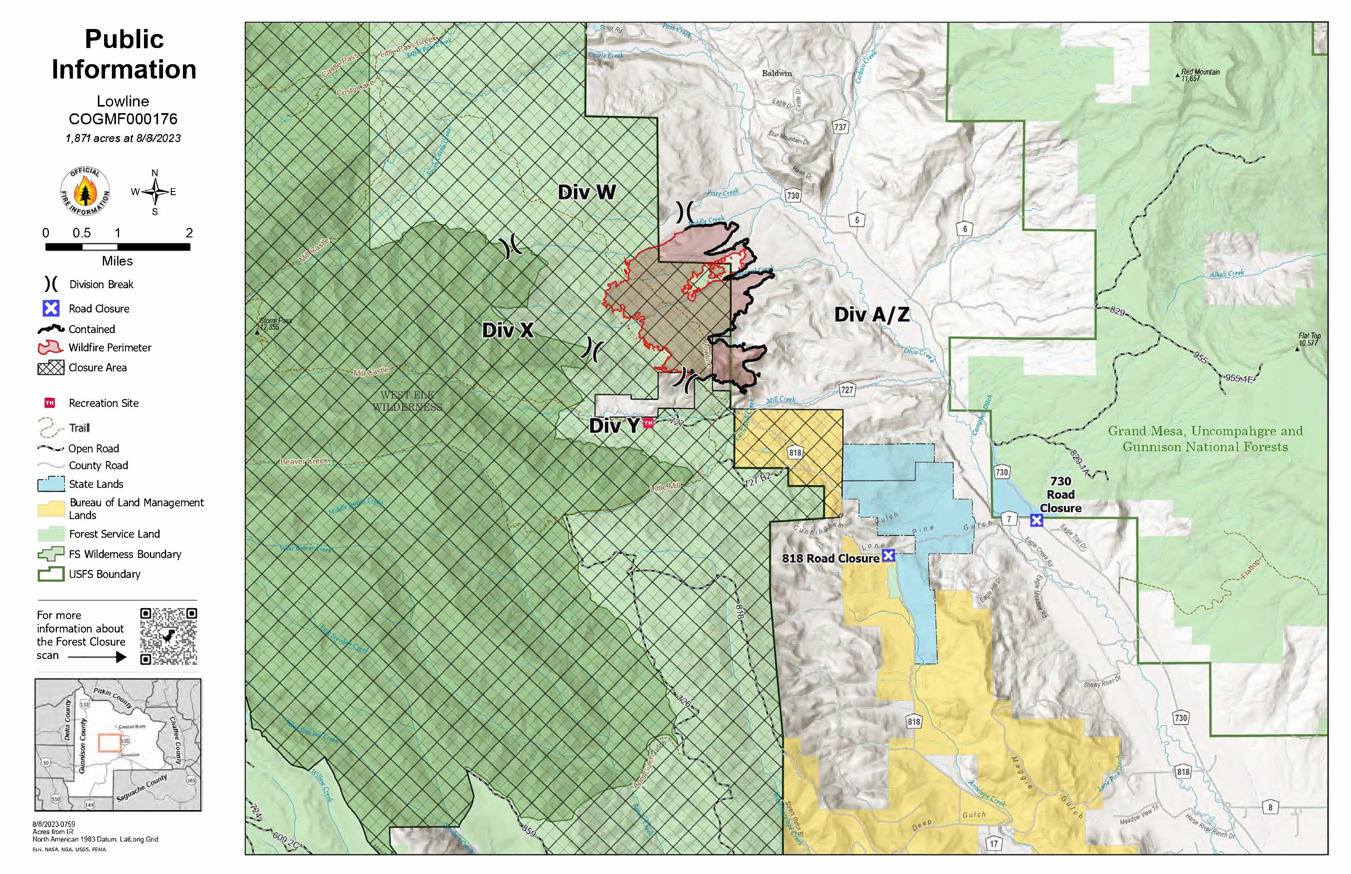
Evacuations, Closures, and Fire Restrictions:
A pre-evacuation order remains in effect for CR 727, Mill Creek. No other evacuations or pre-evacuations are in place near the fire. For additional evacuation information, see Gunnison County Emergency Management at www.gunnisoncounty.org. You may sign up to receive emergency alerts at: https://bit.ly/3QhZVZg.
National Forest area, road, and trail closure: https://www.fs.usda.gov/Internet/FSE_DOCUMENTS/fseprd1126172.pdf. BLM temporary closure: https://tinyurl.com/5n8s7xee .
County Roads in the fire vicinity are barricaded. In the interest of public safety, fire officials ask visitors to be aware of fire traffic and avoid the area.
Fire restrictions in Gunnison County: none currently.
Smoke Outlook reports: https://outlooks.airfire.org/outlook/ed63b240 .
Lowline Fire Statistics:
Size: 1871 acres
Containment: 55%
Total Personnel: 166
Cause: lightning
Location: 14 mi. NNW of Gunnison, CO
Reported: 8:00 am July 26, 2023
For More Information:
Information Phone: 970-648-4470 (public), 970-765-7123 (media)
Email: 2023.lowline@firenet.gov
InciWeb: https://inciweb.wildfire.gov/incident-information/cogmf-lowline-fire
Facebook: www.facebook.com/GMUGFireInfo
###
Actualizacin del Incendio Lowline Miercoles 9 de Agosto 2023
Related Incident: Lowline Fire
Publication Type: News
Actualización del Incendio Lowline
Miercoles 9 de Agosto, 2023 – 9:00 a.m.
Equipo de Manejo de Incidentes Tipo 3
Bryan Gaines, Comandante del Incidente
Teléfono de Información: 970-648-4470 (publico), 970-765-7123 (medios de comunicación)
Correo electrónico: 2023.lowline@firenet.gov
Horario: 8 a.m. – 8 p.m.
Nota Especial: Ahora a las 6:00 a.m., el Equipo de Incidentes del Nivel 3 ya tiene dirreción del incidente. El comandante del Incidente Bryan Gaines elogió al Equipo de Manejo de Incidents del Complejo del las Montañas Rocosas por su trabajo de calidad y su transición fluida.
Situación Actual: Tuvimos una transición exitosa del Equipo de Manejo de Incidentes del Complejo Montañas Rocosas y el Equipo de Manejo de Incidentes Tipo 3. Las condiciones de Bandera Roja persistieron sobre el área de Lowline Fire, lo que resultó en un aumento del humo. No se produjo un crecimiento del perímetro, pero los combustibles en las islas interiores que no eran quemadas completemente continuaron a fumar. Esto resultó en un aumento de aproximadamente 50 acres. Los objetivos para la supresión del incendio Lowline permanece, y los bomberos continuarán evaluando el comportamiento del fuego, caminando las líneas de fuego, trabajando en el fuego y apagando los puntos calientes.
El Equipo de Manejo de Incidentes del Complejo Montañas Rocosas finalizó un plan de protección de estructuras, para ser utilizado por el equipo Tipo 3 y también las agencias locales. Además, la Oficina del Sheriff completara investigaciónes sobre una estructura quemada dentro del perímetro del incendio y determinó que una cabaña deshabitada se perdió durante el comportamiento extremo del incendio, al inicio del Incendio Lowline. Los propietarios de esta estructura han sido notificados. Todas las demás estructuras conocidas cercanas al Incendio Lowline han sido evaluadas y están siendo observando por equipos de bomberos.
Condiciones Climáticas y de Combustibles: Hoy día, los vientos relajarán a 15 mph con ráfagas hasta 25 mph. La humedad aumentará acera de 20% y las temperaturas bajarán a los 70s. Tendremos condiciones de humo durante la noche, con el humo dispersandose a media mañana cuando suben las temperaturas. El comportamiento del fuego permanecerá activo debido a la mala recuperación de la humedad durante la noche y la baja humedad de los combustibles. Una débil oleada de humedad se trasladará al área con un 10% de probabilidad de precipitación hoy, y un 35 % de probabilidad el jueves.
Evacuaciones, Cierres, y Restricciones de Incendios: Hay una orden de evacuación previa vigente para CR 727, Mill Creek. No hay otras evacuaciones o evacuaciones previas cerca del incendio. Para obtener información sobre la evacuación, consulte Manejo de emergencias del condado de Gunnison en www.gunnisoncounty.org. Puede registrarse para recibir alertas de emergencia en sus teléfonos u otros dispositivos en: https://bit.ly/3QhZVZg.
Cierres del Sistema Forestal Nacional: https://www.fs.usda.gov/Internet/FSE_DOCUMENTS/fseprd1126172.pdf.
Cierres temporarios del BLM: https://tinyurl.com/5n8s7xee.
Restricciones de Incendios en el condado de Gunnison: ninguno.
Reportes sobre la perspectiva de humo: https://outlooks.airfire.org/outlook/ed63b240.
Los incendios forestales son una zona de exclusión aérea para aeronaves no autorizadas, incluidos los drones. Si tu vuelas, nosotros no podemos. Para obtener más información, visite http://knowbeforeyoufly.org.
Estadísticas del Incendio Lowline:
Tamaño: 1871 acres
Contenido: 55%
Personas: 166
Causa: Relȧmpago
Locación: 14 mi. NNW de Gunnison, CO
Reportado: 8:00 am July de 26, 2023
Para más Información:
Línea Telefónica: 970-648-4470 (publicó), 970-765-7123 (media)
Correo electrónico: 2023.lowline@firenet.gov
InciWeb: https://inciweb.wildfire.gov/incident-information/cogmf-lowline-fire
Facebook: www.facebook.com/GMUGFireInfo