
Dry Mesa Road Closure
Related Incident: Little Mesa Fire
Publication Type: Closures
Temporary road closures in Delta County on Dry Mesa Road at the intersection with Escalante Rim Road in Escalante Canyon and on USFS Dry Mesa Road at Sawmill Mesa Road junction have been lifted.
Little Mesa Fire August 9 2023 8PM Update
Related Incident: Little Mesa Fire
Publication Type: News
August 9, 2023 – 8 PM – Firefighters were able to hold fire along the Tatum Ridge Road, protect values at risk and scout area. The Little Mesa Fire now has its own Facebook page at https://www.facebook.com/LittleMesaFire. Follow the Little Mesa Fire on Inciweb at https://inciweb.wildfire.gov/incident-information/coupd-little-mesa-fire.
Ridge Fire Community Meeting Thursday August 10 2023
Related Incident:
Publication Type: Announcement
Ridge Fire Community Meeting
Thursday, August 10, 2023, at 7:00 p.m.
Glacier Bible Camp
400 5th Street West
Hungry Horse, MT 59919
Watch Livestream from YouTube to Facebook
Streamed on YouTube and Facebook
https://www.youtube.com/@2023RidgeFire
https://www.facebook.com/ridge.fire.information
Elkhorn Fire Daily Update August 6 2023
Related Incident: Elkhorn Fire
Publication Type: News
Fire Update – Elkhorn Fire, August 6, 2023
McCall, Idaho - Firefighters have prepared structure protection for values at risk across the northwest area of the fire, primarily Magruder Ranch and Vitta Point areas, as the fire grew to an estimated 24,025 acres. There were large strides in planning a network of contingency firefighting lines that tie into Magruder road while taking advantage of fire scars, trail systems and existing previous control features. Long-term planning has begun for firefighting strategies that recognize the differing terrains north and south of the Salmon River. Hand crews have begun work on the contingency lines north of the river to protect property, roads and trails. Mop-up has begun in the Trout Creek area and is progressing well.
Today an Unmanned Aerial System (drone) arrives to conduct infrared operations if aircraft are not available. Structure protection along the river corridor just east of the fire continues but has been hampered by inversions and thunderstorms that limit helicopter flights. The six assigned helicopters remain valuable tactical assets and will be used as frequently as weather permits. Wrapping with fire resistant aluminum foil-type material will soon begin on the Sheep Hill lookout.
Rainfall yesterday reached one-fourth to one-half inch across the landscape of the river corridor, a wetting rain that temporarily reduced smoldering heat and inhibited fire spread. However, a negative aspect of heavy rainfall is the potential for mudslides and for burnt logs to roll down hillsides. A significant chance of some lighter precipitation and scattered thunderstorms continues through Monday.
The US Forest Service Nez Perce-Clearwater and Payette National Forests issued the Elkhorn fire area, roads and trails closure order #01-17-05-23-003, https://www.fs.usda.gov/alerts/nezperceclearwater/alerts-notices/?aid=82169. The closure area spans both sides of the Salmon River but “excludes the Salmon River Wild and Scenic Corridor below the high-water line.”
Beginning today boaters are required to stop at Hancock Campsite on river-left at river mile 26.1 to receive further instruction from a Forest Service representative regarding passing through and camping in the area of the Elkhorn fire. Camping, recreating (i.e., picnic, bathroom breaks and beach walking) and stopping through the area of fire activity is allowed with some exceptions. Upon leaving Hancock Camp there will be no stopping until boaters pass Magpie Creek Camp. After passing Magpie Creek Camp, boaters will be allowed to camp and recreate on a First Come, First Served basis everywhere except: Upper Allison, Allison, Lower Allison, Whitewater Camp, Campbell’s Ferry and China Bar. Upon leaving China Bar, there are no camping restrictions connected to the Elkhorn Fire.
An Temporary Flight Restriction (TFR) is in place. All aircraft (including drones) not assigned to the fire are required to remain out of the TFR area. This includes those intending to land at private ranches under the TFR.
Visit Inciweb for information on wildfires at https://inciweb.nwcg.gov, and follow the Payette National Forest on Twitter at @PayetteForest, and on Facebook https://www.facebook.com/payettenationalforest/
Elkhorn Fire Daily Update August 8 2023
Related Incident: Elkhorn Fire
Publication Type: News
Fire Update – Elkhorn Fire, August 8, 2023
McCall, Idaho – An Unstaffed Aerial System (drone) team plan to conduct infrared operations of the Trout Creek area of the fire today. The fire acreage is estimated at 24,039 acres and is 12% contained. Some operations remain suspended on the Salmon River corridor due to mudslides and debris in the river system.
Crews are using point protection strategy in the fire perimeter. Point protection strategy is a wildfire response strategy, which protects specific assets or highly valued resources from the wildfire without directly halting the continued spread of the wildfire. The strategy takes into account exposure to firefighters, values at risk, impacts to area user groups, and wilderness values. The selected point protection strategy was determined to be the best balance of the protection of values and firefighter safety.
Rain fell on the fire for the third consecutive day, assisting wildland firefighter efforts on the fire. A weak, upper-level ridge will be transiting the area today. A lingering mid-to-upper-level moisture that will lead to a 15 percent chance of rain in the afternoon. Starting in the middle of the week a drying trend will move across the fire area.
The US Forest Service Nez Perce-Clearwater, and Payette National Forests issued the Elkhorn fire area, roads and trails closure order #01-17-05-23-003, https://www.fs.usda.gov/alerts/nezperceclearwater/alerts-notices/?aid=82169. The closure area spans both sides of the Salmon River but excludes the Salmon River Wild and Scenic Corridor below the high-water line.
Boaters are required to stop at Hancock Campsite on river-left at river mile 26.1 to receive further instruction from a Forest Service representative regarding passing through and camping in the area of the Elkhorn fire. Camping, recreating (i.e., picnic, bathroom breaks and beach walking) and stopping through the area of fire activity is allowed with some exceptions. Upon leaving Hancock Camp there will be no stopping until boaters pass Magpie Creek Camp. After passing Magpie Creek Camp, boaters will be allowed to camp and recreate on a First Come, First Served basis everywhere except: Upper Allison, Allison, Lower Allison, Whitewater Camp, Campbell’s Ferry and China Bar. Upon leaving China Bar, there are no camping restrictions connected to the Elkhorn Fire.
An Temporary Flight Restriction (TFR) is in place. All aircraft (including drones) not assigned to the fire are required to remain out of the TFR area.
Visit Inciweb for information on wildfires at https://inciweb.nwcg.gov, and follow the Payette National Forest on Facebook at https://www.facebook.com/payettenationalforest
Elkhorn Fire Daily Update August 9 2023
Related Incident: Elkhorn Fire
Publication Type: News
Fire Update – Elkhorn Fire, August 9, 2023
McCall, Idaho –The fire’s acreage remains 24,039 with containment at 12%. A containment line has been established from the Trout Creek drainage to Whitewater Ranch. The six assigned helicopters performed a wide range of delayed supply, reconnaissance and other operational duties after the inversion lifted late in the morning. U.S. Forest Service support of Salmon River boaters resumed yesterday at the Hancock Campsite after a temporary suspension due to safety hazards along the river.
A heavy equipment taskforce is creating a vegetation fuel break from Magruder Corridor Road toward the 2020 Shissler fire scar, brushing and limbing along the trail system while minimizing impact on the terrain. Fallers are working on indirect fire line to hold the fire east of FS Road 421. Firefighters will construct handline along the edge of the Dixie fire scar at FS Road 9550 toward Magruder Corridor Road and following the 505 UTV trail.
There were no thunderstorms yesterday as the weather entered a several-day warming and drying trend. Weather permitting, in the near future firefighters are planning to reengage along the southeast fire perimeter, basing operations from the Lantz Bar. An Unstaffed Aircraft System (drone) is being utilized to look for hot spots.
The U.S. Forest Service Nez Perce-Clearwater, and Payette National Forests issued the Elkhorn fire area, roads and trails closure order #01-17-05-23-003, https://www.fs.usda.gov/alerts/nezperceclearwater/alerts-notices/?aid=82169. The closure area spans both sides of the Salmon River but excludes the Salmon River Wild and Scenic Corridor below the high-water line.
Boaters are required to stop at Hancock Campsite on at river mile 26.1 to receive further instruction from a Forest Service representative regarding passing through and camping in the area of the Elkhorn fire. Camping, recreating (i.e., picnic, bathroom breaks and beach walking) and stopping through the area of fire activity is allowed. Upon leaving Hancock Camp there will be no stopping until boaters pass Magpie Creek Camp. After passing Magpie Creek Camp, boaters will be allowed to camp and recreate on a First Come, First Served basis everywhere except: Upper Allison, Allison, Lower Allison, Whitewater Camp, Campbell’s Ferry and China Bar. Upon leaving China Bar, there are no camping restrictions connected to the Elkhorn Fire.
An Temporary Flight Restriction (TFR) is in place. All aircraft (including drones) not assigned to the fire are required to remain out of the TFR area.
Visit InciWeb for information on wildfires at https://inciweb.ncwg.gov and follow the Payette National Forest on Facebook at https://www.facebook.com/payettenationalforest
Black River Complex Daily Update August 9 2023
Related Incident: Black River Complex
Publication Type: News
CORDUROY FIRE
Start Date: July 12, 2023, Location: 20 Miles SW Alpine, Percent Contained: 10, Size: 1,027 acres, Cause: Lightning, Vegetation: Timber (Litter and Understory) Medium Logging Slash, Resources Assigned: 3 Engines, 3 Crews, 1 Dozer, 3 Water tenders.
Operations: The Corduroy fire received rain yesterday and the perimeter is becoming more secure. Firefighters will monitor and patrol today to look for any threats to control lines and will work to complete structure protection preparations at Hannagan Lodge.
BOUNDARY FIRE
Start Date: July 27, 2023, Location: 30 Miles SW of Alpine, Percent Contained: 0, Size: 879 acres, Cause: Lightning, Vegetation: Timber (Litter and Understory) Brush (2 feet), Resources Assigned: 2 Crews, 4 Engines, 2 Water tenders.
Operations: Fire crews are working to connect fire to existing road systems on the San Carlos Apache Indian Reservation. The fire received rain yesterday and movement is minimal with some creeping and backing where fuels are receptive.
WILLOW FIRE
Start Date: July 27, 2023, Location: 12 Miles SW of Alpine, Percent Contained: 0, Size: 401 acres, Cause: Lightning, Vegetation: Timber (Grass and Understory) Medium Logging Slash, Resources Assigned: 4 Crews, 6 Engines, 3 Dozers, 1 Water tender.
Operations: The prep work on highway 191 has been completed and a handline on the southern flank is expected to be completed today. The Willow fire received rain yesterday and crews will assess today, and patrol and monitor for heat sources that may remain.
Closures: To provide for public and firefighter safety, highway 191 is closed in both directions from mileposts 231.3 to 239.7. Highway 191 will temporarily reopen to traffic at 8:00pm tonight until 6:00am tomorrow morning.
Weather: Today’s forecast calls for thunderstorms, a 70% chance of precipitation this afternoon, a high of 69 degrees, and winds up to 18 mph.
Values at risk: Sensitive species in surrounding areas, cattle and grazing areas, watersheds, riparian areas, impacts to Highway 191, Hannagan Lodge, and nearby electric powerlines.
Restrictions: The Apache-Sitgreaves National Forests are in Stage 1 Fire Restrictions. For details, please visit https://www.fs.usda.gov/alerts/ /alerts-notices/?aid=81123.
Smoke: Go to https://fire.airnow.gov/ to see the latest smoke conditions in your community. Smoke may be visible from Hwy 191, especially at night.
Official fire information:
• Inciweb: https://inciweb.wildfire.gov/incident-information/azasf-black-river-complex
• Incident Email and Phone: 2023.blackrivercomplex@firenet.gov, 928-245-1585
• Facebook: https://www.facebook.com/apachesitgreavesnfs
• Apache-Sitgreaves website: Apache-Sitgreaves National Forests - Home (usda.gov)
Ridge Creek Fire Closure updated 9723
Related Incident:
Publication Type: Closures
Idaho Panhandle National Forest: Ridge Creek Fire Closure
Order Number: 01-04-03-23-004
The purpose of this Order is for public and firefighter safety due to heavy fire traffic on the area impacted on the Coeur d’Alene River RD, and prohibits all methods of travel (foot, mechanized, motorized and stock) on Forest Service Roads 392, 428A, 437, 1511, 1530, 1552, 1587 and Forest Service Road 406 north of the junction with Forest Service Road 206, Forest Service Trails 69, 78, 234, and 802 as well as within the described area.
DESCRIBED AREA/ROADS/TRAILS
Area: Forest Service land north of FSR 206, west of FSR 209 and FSR 385, and south of FSR 332. Forest Service land surrounding and north of the Yellowbanks Creek area and west of FSR 1535.
Roads: All FSRs within described area: FSRs 392, 428A, 437, 1511, 1530, 1552, 1587. FSR 406 north of the junction with FSR 206.
Trails: Forest Service Trails 69, 78, 234, 577, and 802.
This order shall be in effect from September 7, 2023 at 1800 through September 30, 2023 at 0600, unless rescinded.
Brady Fire Emergency Closure for Public Health and Safety
Related Incident:
Publication Type: Closures
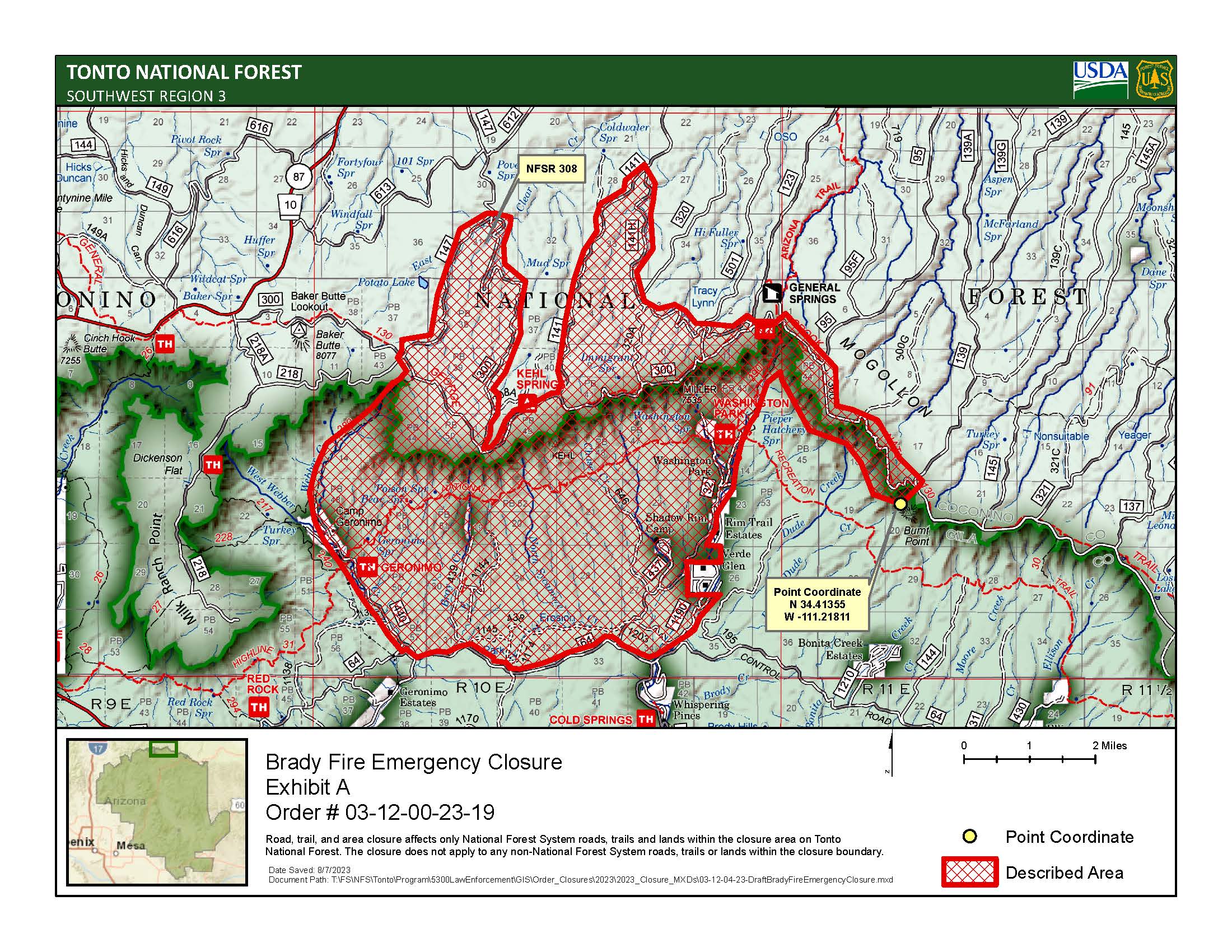
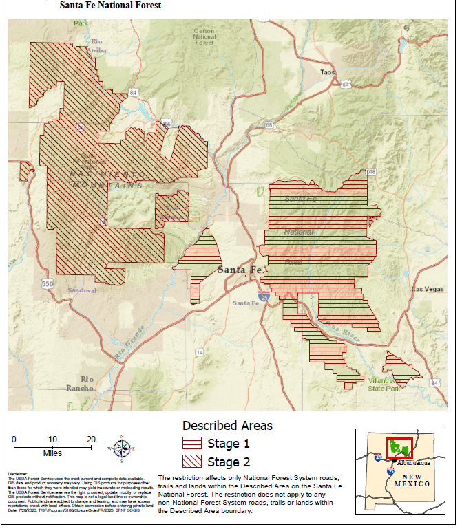
West Side in Stage 2 East Side in Stage 1 Fire Restrictions
Related Incident: Black Feather Fire
Publication Type: Announcement
Stage 2 fire restrictions are in effect on the Santa Fe National Forest lands west of the Rio Grande as of 8:00 a.m. Thursday, July 27. All Santa Fe National Forest lands east of the Rio Grande are in Stage 1 fire restrictions allowing for campfires and charcoal grilling ONLY in designated forest campgrounds and picnic areas.
Stage 2 fire restrictions PROHIBIT the following activities:
- Building, maintaining, or using a fire, campfire or stove fire.
- Smoking, except within an enclosed vehicle or building, on a developed recreation site, or while stopped in an area at least three feet in diameter that is cleared of vegetation and flammable material.
- Welding, or operating an acetylene or other torch with open flame.
- Operating any equipment powered by an internal combustion engine, including chainsaws, between the hours of 10 a.m. and 6 p.m.
- Driving off designated roads. Visitors may park in areas cleared of vegetation within 10 feet of the roadway, or in designated parking areas.
Stage 1 fire restrictions PROHIBIT these activities:
- Building, maintaining, or using a campfire, charcoal fire, or stove fire EXCEPT in a designated Forest Service campground or picnic are in a manufactured structure built for that purpose.
- Smoking, except with an enclosed vehicle or building, on a developed recreation site, or while stopped in an area at least (3) three feet in diameter cleared of vegetation and flammable material.
Visitors may use stoves, grills and lanterns with an on/off switch fueled by propane or other liquid petroleum gas (LPG) fuels that meet manufacturer’s safety specifications.
Stage 2 fire restrictions are a proactive way to reduce the risk of human-caused wildfires, protect natural and cultural resources, and enhance public and firefighter safety. Forest visitors are asked to use extreme caution when fire restrictions are in place.