
Ridge Creek Fire Daily Update for August 9 2023
Related Incident:
Publication Type: News
Ridge Creek Fire
Idaho Panhandle National Forests, Coeur d’Alene River Ranger District
Fire Information: 208-953-7022
Media Information: 989-292-9373
https://inciweb.nwcg.gov/incident-information/idipf-ridge-creek
August 9, 2023
Location: Approximately 3.5 miles east of the north tip of Hayden Lake, along the Hayden Creek Road (FSR 437) in the Ridge Creek drainage
Start Date: 8/3/2023 Cause: Human/Under Investigation Size: 1200 acres Containment: 0%
Total Personnel: 173 Engines: 6 Heavy Equipment: 6 Crews: 4
Yesterday the Kootenai Office of Emergency Management issued an alert defining an additional Ready area in the vicinity of Bunco Road. A map of the area is provided with this update and additional notes are provided below.
The Coeur d’Alene Dispatch Zone also issued Stage II Fire Restrictions in the Idaho panhandle. Additional information is provided with this update and noted below.
Weather has been moderate over the last several days with substantial cloud cover and intermittent rains which has in turn moderated fire behavior. The fire area will see a warming trend over the weekend that will continue into the coming week. An approaching front today may result in gusty winds this afternoon which may contribute to areas of active fire behavior.
Hand crews will continue to work on the south end of the fire along Forest Service Road 437 (Hayden Creek Rd), tying this improved line to mechanical lines that were constructed along ridgeline tying into the road extending northward to the area of the Hudlow Saddle. Crews will continue to improve fireline using the FSR 406 road to the northeast of the fire, working to bring improved fireline around the north end of the fire to the Cedar Saddle. Fireline will extend south from the Cedar Saddle along FSR 625 (North Fork Rd) to FSR 437 (Hayden Creek Rd).
The infrared (IR) flight scheduled for last night was canceled due to cloud cover over the fire; a flight has been ordered for tonight. Fire size has not been updated due to the lack of an IR flight.
EVACUATION STATUS
Yesterday, the Kootenai County Office of Emergency Management issued an alert to inform residents of the identification of an additional READY, SET, GO area in the vicinity of the Bunco Road area. This is in addition to the area defined to the west of the fire bordering Hayden Lake. Both areas are defined as GET READY status areas. In this case, residents are cautioned to heighten their awareness of fire information, be familiar with evacuation preparation and procedures should it become necessary, and consistently adhere to good fire prevention measures.
The Kootenai Office of Emergency Management provides the following direction for residents in these areas designated with a GET READY status: “Please continue to monitor official sources and call 208-446-2292 for any questions regarding evacuations. Follow Kootenai County Emergency Management Facebook Page for updates and sign up for automated Kootenai Alert for emergency alerts. https://www.kcsheriff.com/186/Emergency-Management.”
A map of the revised Get Ready areas is included with this update below.
CLOSURES AND SPECIAL MESSAGES
Yesterday the Coeur d Alene Dispatch Zone issued Stage II Fire Restrictions across the Idaho panhandle. An infographic is included with this update that details the activities that are prohibited under the restriction.
Firefighting aircraft are actively engaged on multiple fires in the region and will continue to use area waterways, including Hayden Lake, for fire suppression efforts. This means that residents and recreational boaters are likely to see either helicopters or fixed-wing aircraft using the lake. For planes in particular, this requires a long, linear approach and exit from the lake. This restricts their ability to maneuver abruptly should watercraft be within their flight path, an obvious safety hazard. Pilots that have to deviate to avoid watercraft will also be delayed in acquiring water, inhibiting their fire suppression efforts. All lake users should be on the lookout for approaching aircraft. If firefighting aircraft are in the area, boaters should clear the center of the lake and move toward the shoreline.
The Idaho Panhandle National Forests issued an emergency closure (Closure Order #01-04-03-23-002) effective August 4, 2023. This Order is for public and firefighter safety due to heavy fire traffic on the area impacted on the Coeur d’Alene River Ranger District, and prohibits all methods of travel (foot, mechanized, motorized and stock) on Forest Service Roads 392, 428A, 437, 1511, 1530, 1552, 1587 and Forest Service Roads 206 and 406 north of their junction, Forest Service Trails 69, 78, 234, and 802 as well as within the described area.
WEATHER AND FIRE BEHAVIOR
Partly to mostly cloudy skies with a 10% chance of precipitation. High of 76 degrees with a minimum relative humidity of 39%. Winds from the southwest 6 to 11 mph with afternoon gusts to 25 mph.
Margarita Fire Daily Update August 9
Related Incident: Margarita Fire
Publication Type: News
(MOCLIPS, Wash.) – The Margarita Fire started August 2nd at approximately 12:30am on the Quinault reservation, approximately 1.5 miles NE of Moclips. It is mostly burning in a timber sale unit that is a mix of cedar slash and standing trees, surrounded by heavy timber. Western Washington Type 3 Incident Management Team assumed command of the fire on August 4th.
The fire is currently 61 acres and 75% contained. Firefighters yesterday did incredible work, making progress on fire suppression ahead of expectations. They focused on mopping up in the southwest corner of the fire area in some standing trees. At the north end of the fire, an excavator was removing tree stumps and crews and equipment worked to scatter timber slash to the interior of the fire to reduce the risk of spotting outside of the fire perimeter. They also limbed up and then burned out trees to secure fire line up to the M-800 road. As of yesterday evening, 112 people, 10 engines, three water tenders, a dozer, and two helicopters were working to suppress the fire.
The objective today is to continue mopping up and monitoring the timber stringers at the east flank of the fire. Firefighters will also mop up fuels along the fire’s south edge. While the rain overnight and this morning is helpful, it is truly the hard work of the firefighters that is making a difference.
The only evacuation warning is a Level 2 – Get Set – for the community of Quinault Village, also known as Moclips Estates. Residents should have essentials packed and be ready to go if conditions change.
Weather today is forecast to be cloudy in the morning and mostly cloudy in the afternoon. There is a 40% chance of wetting rain, defined as an amount of rain that will typically wet fuels enough to substantially prevent new ignitions while reducing spotting and slowing rates of spread. The prediction is for south winds at 6-8 mph in the morning, shifting to northwest at 7-12 mph in the afternoon with a high temperature of 68 degrees.
You can support firefighting efforts by observing local burn bans. The weather is forecast to return to warm, dry conditions tomorrow and through the middle of next week. Grays Harbor County currently has restrictions on all outdoor burning. Charcoal and wood burning, recreational campfires, residential yard waste and land-clearing burning are prohibited until further notice.
Ridge Fire Daily Update August 9 2023
Related Incident:
Publication Type: News
Ridge Fire Incident Update Date: 08/09/23
Fire Information: 406-998-6074
Hours: 8:00 AM – 7:00 PM
Email: 2023.ridge@firenet.gov
Incident Website: http://inciweb.wildfire.gov/incident-information/mtfnf- ridge-fire
Facebook - New Ridge Fire Facebook Page: https://www.facebook.com/ridge.fire.information
YouTube Channel with Ridge Fire Videos: ![]() https://www.youtube.com/@2023ridgefire
https://www.youtube.com/@2023ridgefire
Location: 6 miles southeast of Hungry Horse
Size: 2,940 acres
Percent Contained: 0 %
Cause: Lightening
Start Date: July 30, 2023, 3:45 PM
Vegetation: Timber (Litter and Understory), Tall Grass, and Brush
Number of Personnel Assigned: 249
Hungry Horse Reservoir Closed Due to Fire Activity
Hungry Horse Reservoir is closed until further notice. All National Forest System lands in the area and National Forest System roads 38 and 895 will be closed to public use for public and firefighter safety.
CURRENT SITUATION: Firefighters were able to keep the fire to 2,940 acres, with minimal growth from yesterday. While maintaining safety for firefighters, crews will continue to work in steep terrain with dry fuel, and attack the fire directly where possible. Because there are limited options to go direct, firefighters are also continuing to use indirect firefighting tactics – removing fuel from the fire’s edge and constructing and improving containment lines. The priority is to protect private residences and critical infrastructure on the fire’s western edge and keep it east of FS Road #38. Yesterday, crews were able to successfully improve the direct line on the southern border of the fire along FS Road #38 (East Side Road). On the northwestern perimeter of the fire, dozers were utilized to open up the 590E Road – also removing fuel from the fire’s path. Firefighters did not see any movement on the eastern flank of the fire and will continue to monitor. As resources continue to arrive, there will be an increase in fire equipment entering and exiting Highway 2 – use caution.
Incident personnel will continue to monitor weather and fire conditions to determine when aircraft can be utilized to aid ground resources. Weather permitting, aircraft will be used on the eastern front of the fire.
The following road closures are in effect:
- FS Road #38 (East Side Road #38) is closed to all public traffic east of the junction of FS Road #497 (Desert Mountain Road) and East Side Road #38.
- FS Road #895 (West Side South Fork Road #895) is closed to all public traffic starting at mile 15, near the Lid Creek Campground.
- West Side South Fork Road #895 from the Hungry Horse Dam Visitor Center to the existing closure at mile 15, near the Lid Creek Campground. Pre-evacuation notice in effect for private property along SF Abbot Creek on the west side of the fire.
WEATHER AND FIRE BEHAVIOR: Wind is expected at 12-17 MPH in the fire area with gusts up to 30 in the afternoon. Overnight recovery relative humidity was in the 50% and fire activity was low. The fire is burning in heavy fuels and steep terrain.
CLOSURES AND SPECIAL MESSAGES: As of 6:00 am, California Interagency Incident Management Team 4 has assumed management of the incident. Residents should stay alert for changing conditions and visit ready.gov/wildfires for preparing for wildfires. For up-to- date information on the Ridge Fire, please visit InciWeb, Flathead National Forest Facebook, @2023ridgefire, and Flathead County Sheriff’s Office Facebook for evacuation information.
Please refer to http://inciweb.wildfire.gov/incident-information/mtfnf-tin-soldier-complex for the Tin Soldier Complex incident information.
Closure Order 0621352304 Salmo Basin Fire
Related Incident: Salmo Basin Fire
Publication Type: Closures
Closure Order: 06-21-35-23-04
Salmo Basin Fire Closure
Pursuant to 16 USC § 551 and 36 CFR §§ 261.50(a) and (b), and to provide for public safety, the following acts are prohibited within the Newport-Sullivan Lake Ranger District of the Colville National Forest. This Order is effective August 9, 2023, through October 31, 2023, unless rescinded sooner.
PROHIBITIONS:
1. Entering into or being upon an area which is closed for the protection public health or safety, as described below and displayed on the attached map, Exhibit A [36 CFR § 261. 53(e)].
2. Being on a National Forest System trail as described below and displayed on the attached map, Exhibit A [36 CFR § 261.55(a)].
3. Being on a National Forest System Road as described below and displayed on the attached map, Exhibit A [36 CFR § 261.54(e)].
CLOSURE AREA DESCRIPTION:
Starting in T40N R45E S31 at the SW corner of the section the closure boundary follows the Township line North to the NW corner of section 6 at the Canadian Border. The closure boundary then follows the Range line East along the Canadian Border to the NE corner of Section 1 at the Idaho Border, and then follows the Township line South along the Washington/Idaho Border to the Shedroof Divide Trail #512. From there, the closure boundary follows the Shedroof Divide Trail #512 South to the Shedroof Cutoff Trail #511, and then the Shedroof Cutoff Trail #511 to NFS Road 2220000. The closure boundary then follows NFS Road 2220000 North to T40N R45E S34, and from there follows the Range line in Section 34 West to the Bear Pasture Trailhead and Crowell Ridge Trail #515, then follows the Crowell Ridge Trail #515 West to the SW Quarter of Section 31, and then follows the Range line in Section 31 West back to the beginning location. All NFS roads, trails and land within the lines described above are included in the closure area. No State DNR or Private lands or roads are closed under this order. Closed Trails: Salmo Divide Trail #535 Salmo Basin Trail #506 Salmo Cabin Trail #531 Closed Roads: NFS Road 2220000/Sullivan-Salmo Rd NFS Road 2220270/Salmo Lookout Rd NFS Road 2220274 NFS Road 2220300 See attached closure map.
EXEMPTIONS:
Pursuant to 36 CFR § 261.50(e), the following persons are exempt from this order: 1. Any federal, state, or local officer, or member of an organized rescue or fire fighting force in the performance of an official duty. 2. Persons with Forest Service Permit No. FS-7700-48 (Permit for Use of Roads, Trails, or Areas Restricted by Regulation Order), specifically exempting them from this Order. These prohibitions are in addition to the general prohibitions in 36 CFR Part 261, Subpart A. Violations of this prohibition are punishable by a fine of not more than $5,000 for an individual or $10,000 for an organization, or imprisonment for not more than 6 months, or both (16 U.S.C. § 551; 18 U.S.C. §§ 3551, 3559, 3571, and 3581). Executed in Colville, Washington, this 9th Day of August 2023.
Signed, Joshua P. White Forest Supervisor Colville National Forest
9 de Agosto 2023 Reporte Informe del incendio Flat
Related Incident: Flat Fire
Publication Type: News
This is the Spanish-language update. Some operational words may not translate well.
9 de agosto, 2023
Informe actual del Incendio Flat
Extension: 33,811 acres
Inicio:15-Julio-23
Origen: 2 millas Sureste de Agness, OR
Contencion: 39%
Personal: 812
Recursos: 20 camiones de bomberos l 23 cuadrillas de bomberos l 4 buldócer l 27 cisternas l 9 máquinas masticadoras l 7 helicópteros
Resumen: el día de ayer, con el objetivo de reducir la actividad del incendio, se condujeron irrigaciones desde los helicópteros. Se continúa quemando la materia de combustión más pequeña pero aún se puede observar el material de mayor tamaño consumiéndose lentamente. Afortunadamente, esta situación limita la capacidad de propagación en el incendio. Durante el día de hoy y mañana, se espera experimentar temperaturas mas frescas con un porcentaje de humedad relativa mas alta. Sin embargo, para el fin de semana se dará una incrementación de estas. Por esta razón, los bomberos se encuentran listos para cualquier cambio potencial en la actividad del incendio.
Actividades para el día de hoy: Los trabajadores están empezando el trabajo arduo de la estabilización del suelo en áreas que han sido impactadas por el fuego, así como también se están dando las actividades de supresión. Se podrá observar la presencia del humo proveniente de algunos espacios de emanación de calor en la porción Suroeste. Estas áreas calientes se localizan entre las líneas de contención. Los bomberos prosiguen con el asesoramiento y mejorando de las líneas de contención alternativas ya existentes. Permanecen en el área de Agness, los encargados de proteger la infraestructura de la zona en peligro.
Debido a la incrementación del tráfico por la presencia de los bomberos, se hace un llamado a los motoristas que manejen con cautela poniendo atención al tráfico en sentido contrario, mantener una baja velocidad y conducir con las luces delanteras del vehículo encendidas.
Condiciones climáticas: La temperatura se estará presentando ligeramente fresca con condiciones húmedas sobre el área del incendio. Se podrán observar vientos similares al día de ayer con un flujo Noroeste en horas de la tarde. Para el jueves de esta semana se esperan condiciones climáticas similares hoy en día. Para el viernes se predice el inicio de grados de temperatura y porcentajes de humedad más bajos.
Impacto del humo: Se podrá observar la presencia del humo desde las áreas aledañas al incendio. Pronósticos acerca del humo, puede encontrarse en la página web: https://outlooks.wildlandfiresmoke.net/outlook/b74901f7?
Cierres de áreas: El Bosque Nacional de Rogue River-Siskiyou, emitió una orden de cierre incluyendo senderos, carreteras y parte del rio Illinois. Esta orden de cierre abarca Oak Flat Campground, Game Lake Campground, Wildhorse Campground y el Lookout Recreacional de Snow Camp. La carretera forestal de Chetco River Road (FR 1376) y la de Chetco/Pistol River Road (FR 1407) actualmente se encuentran cerradas. Esta nueva orden de cierre permitirá al público el acceso a el área para nadar de Big Rock en el Rio Illinois.
Evacuaciones: Todos los niveles de evacuación han sido reducidos a un Nivel 1 “Prepárese” para todas las áreas en las proximidades del Incendio Flat. https://tinyurl.com/currycountyem
Orden de restricción: Actualmente, el Nivel de Peligro de Incendio es “Extremo”. El Bosque Nacional de Rogue River-Siskiyou ha dictado un Nivel 2 de restricción para el público en general. Para más información: https://tinyurl.com/ueuznr6e
Por favor siga todas las restricciones en el área para prevenir incendios forestales. Conozca el área de recreación antes de visitarla. Revise el pronóstico del tiempo y las restricciones en el uso de fogatas que existen en su destino de recreación.
Linea Informativa:(541)216-4579 Noticieros: (541)237-6369 Email: 2023.flat.or@firenet.gov
Facebook: facebook.com/flatfireoregon2023 Twitter: twitter.com/FlatFireOR2023 Inciweb: bit.ly/FlatFireOR
Double Back Fire Daily Update August 9 2023
Related Incident: Double Back Fire
Publication Type: News
August 9, 2023
Size: 1,320 acres
Containment: 80%
Date Started: August 6, 2023
Cause: Unknown
Structures: There has been confirmation of three outbuildings lost.
Evacuations: There were voluntary evacuations in place initially but those have been since lifted.
The Double Back Fire started on August 6, 2023, and was responded to by multiple fire departments from Johnson County initially. Texas A&M Forest Service was requested for assistance at 3:00 p.m. and responded with aviation resources, heavy equipment, and engines from Texas A&M Forest Service and Texas Intrastate Fire Mutual Aid System (TIFMAS). Multiple departments from Johnson, Hood, Erath, Bosque, Somervell, and Parker counties are working in Unified command with Texas A&M Forest Service, and Texas Division of Emergency Management (TDEM).
Closures: There are no road closures at this time.
Yesterday: Engine crews and a dozer were able to construct containment lines directly against the fire’s edge and keep the fire from spreading into some still unburned areas. This led to an overall reduction in the area burned as crews isolated some of the areas they previously expected to burn. Resources did observer some flare ups as interior pockets of unburned fuels continued to burn themselves up inside the burn perimeter. Engines continued to patrol around the fire and search for any areas of heat to suppress. Additionally, crews worked along some of the roads around this fire making sure that flames and heat along the roads are out and not presenting any risk to the public.
Today: Crews are going to continue patrolling around the area and the fire watching for any areas of heat or activity. With how patchy some of this fire burned, there may continue to be smoke visible from the area even after the fire is declared contained. Residents can expect to see some smoke or ash raising from the burned area as the scar remains even after the fire. High winds can pick up tall columns of ash that look likes smoke but are just being blown by high winds over loose soil.
Weather and Fire Behavior: High winds are expected again today with gusts between 25 and 30 mph. Temperatures and relative humidity should be similar to yesterday’s but will recover to 75% tonight. Very high to extreme fire danger will continue across North Texas for the next several days.
Fire Information
Adam Turner
Public Information Officer, Texas A&M Forest Service
Email: adam.turner@tfs.tamu.edu
Phone: 940-328-9158
Inciweb: https://inciweb.wildfire.gov/incident-information/txtxs-storage-fire
Facebook: https://www.facebook.com/AllHazardsTFS
Twitter: https://twitter.com/AllHazardsTFS
Sourdough Fire Update August 9 2023
Related Incident:
Publication Type: News
Resources: 388 Total Personnel | 9 Hand Crews | 26 Engines | 5 Water Tenders | 6 Helicopters
(Newhalem, Wash.) -- The Sourdough Fire started with a lightning strike on July 29 near Diablo in the steep and rugged terrain of Ross Lake National Recreation Area, 7 miles northeast of Newhalem. The Washington State Department of Transportation in partnership with the Sourdough Fire Incident Northwest Management Team 10 and National Park Service reopened State Route 20/North Cascades Highway from milepost 120 in Newhalem to milepost 156 just west of Rainy Pass, located 45 miles west of Winthrop, at 9 a.m. on Wednesday, August 9. While the road is passable the National Park Service has closed camping, trailheads, overlooks, pullouts, and other recreation east of Newhalem.
Yesterday: Moist, favorable conditions kept fire behavior moderated. The Sourdough Fire had limited growth and is estimated at 1,748 acres. Firefighters continued prepping along State Route 20 between Newhalem and just east of Gorge Lake, reducing fuels along the corridor. Hazard trees were removed along the highway, minimizing the threat to both firefighter and public safety. Crews working in Diablo continued to mop up and patrol around structures, improving their protection if the fire approaches. Power was restored to the North Cascades Environmental Learning Center. Crews worked throughout the day to secure the fire line on the Diablo Dam Road. Two structures along the Sourdough Trail, including the Sourdough Lookout, were protected with a fire-resistant wrap. Aircraft monitored fire activity, and helped on-the-ground resources keep the fire from progressing further west. Firefighters worked on improving access to the powerline by reducing fuels in the area and conducting chipping operations. Crews improved protection of the cabins around Ross Lake Resort by mopping up and plumbing around the structures.
Today: Crews will continue to mop up and secure line around the structures in the Diablo community. As weather allows, aviation resources will be used to check the fire’s spread around the east and west flanks of the fire. Power has been restored at North Cascades Environmental Learning Center, and firefighters east of the fire will focus on monitoring the Sourdough Creek drainage. Resources working in the powerline corridor will monitor and improve control lines and begin moving hose lay into the area.
Weather: Rain and higher humidity is forecast over the Sourdough Fire today, which will limit any fire spread around the entire perimeter.
Safety: With State Route 20 now open, fire managers ask that you drive defensively and not interfere with the firefighting operations.
Smoke: Smoke from the Sourdough Fire may affect communities around the region. Information about current conditions and a smoke forecast is located at: https://wasmoke.blogspot.com.
Closures and Evacuations: Evacuations are in effect for the North Cascades Environmental Learning Center and the community of Diablo. Trail, area and camp closures are in effect; for more information, go to: https://www.nps.gov/noca/planyourvisit/fire-closures.htm
Lost Horse Creek Fire Update for Wednesday August 9 2023
Related Incident: Lost Horse Creek Fire
Publication Type: News
Lost Horse Creek Fire Update
August 9, 2023
Incident Commander: Peter Butteri
Start Date: July 28, 2023
Location: 22 miles N of Fairbanks, AK
Cause: Lightning/Natural
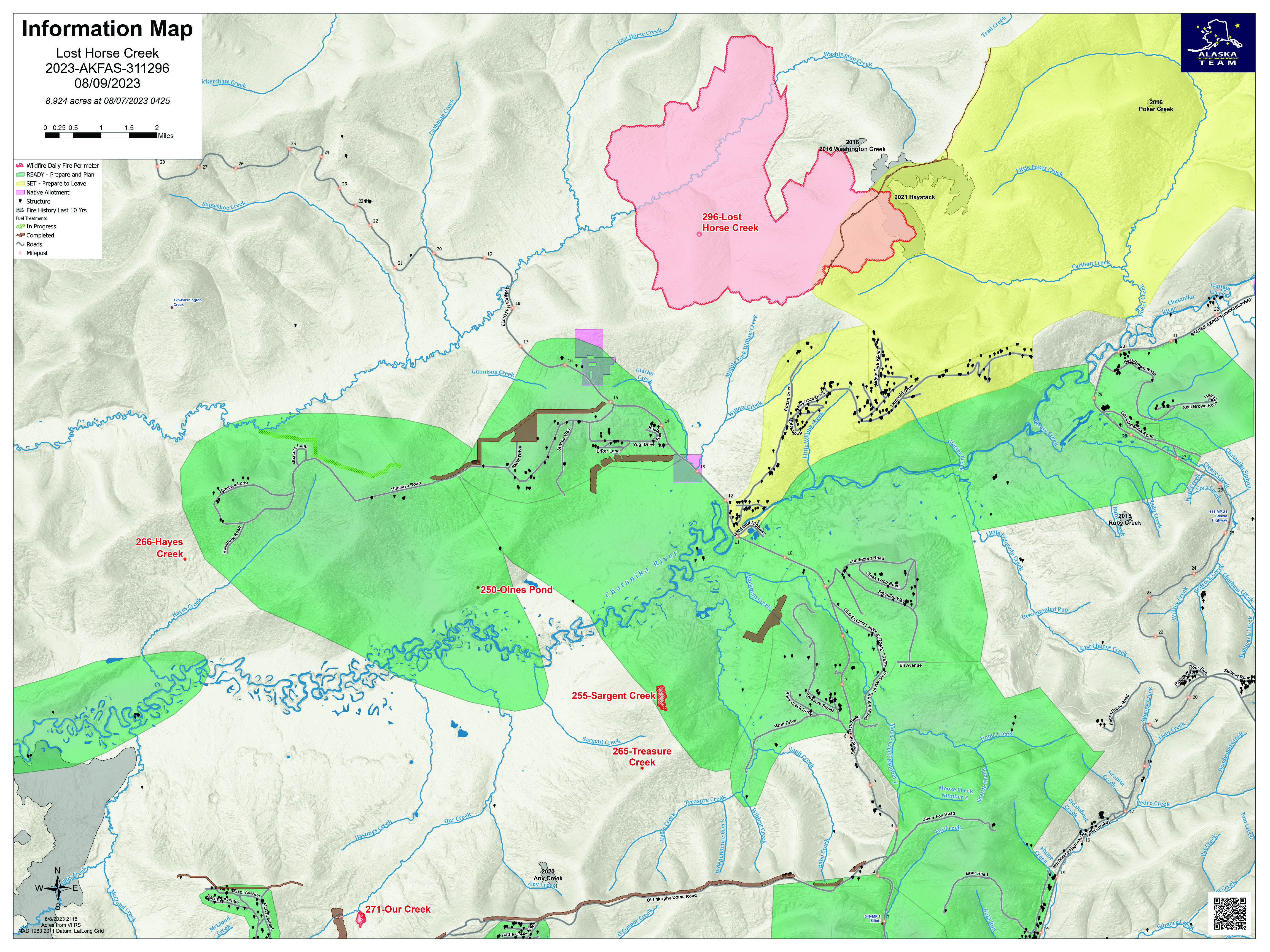
Fire Size: 8,924 acres
Containment: 0%
Total Personnel: 238
(Fairbanks, AK) – Firefighters on the Lost Horse Creek Fire (#296) are assessing structures along the Elliot Highway up to mile 32. Structure protection continues on Middle Fork Road and Lower Haystack. Masticator work started yesterday on the contingency line going west toward the Elliot Highway to open up an old fuel break. Crews are mopping up the control line on the southeast side of the fire and advancing east as they build the Chatanika contingency line.
Moderating weather including cooler weather and likely showers will decrease fire behavior, however, scattered thunderstorms and stronger winds are also in the forecast. The fire area will continue to experience dense smoke, which could lift somewhat with expected scattered showers and winds.
The Sargent Creek Fire (#255) and Our Creek Fire (#271) are in the final stages of mop up; the fires at Murphy Creek (#320), Treasure Creek (#265), Olnes Pond (#250) and Hayes Creek (#266) are in monitor status.
EVACUATIONS: As of Monday, August 7, the evacuation status for Upper Haystack has been changed from Level 3 (GO) to Level 2 (SET). Residents who evacuated the area may return to their homes. All other roads in the Haystack subdivision remain at Level 2 (SET). Although conditions are improving in the area, there is still a potential threat. Residents are advised to remain vigilant and be prepared to evacuate if necessary. Fairbanks North Star Borough, AK | Official Website (fnsb.gov)
CLOSURES: Alaska State Parks has closed the Olnes Pond campground to support fire operations. The Bureau of Land Management, Eastern Interior Field Office issued an evacuation and closure order for the western portion of the White Mountains National Recreation Area effective midnight on August 6 until September 1, unless modified. The evacuation and closure include trails, public use cabins, trail shelters and the Wickersham Dome Trailhead near Elliott Highway mile 28, which may be used by firefighters. See: Alaska Fire Restrictions | Bureau of Land Management (blm.gov).
AIR QUALITY ADVISORY: Smoke production, transported northward by Chinook winds, has been significant from the 151 active fires in Alaska. Any community adjacent to an active fire may experience periods of degraded air quality. Take measures to limit time outdoors and reduce your exposure to hazardous air quality. For smoke forecast and air quality measures, see Fire and Smoke Map (airnow.gov).
TEMPORARY FLIGHT RESTRICTIONS (TFR) are in effect until September 1, 2023. For details, see: 3/0799 NOTAM Details (faa.gov).
Public Information: (907) 921- 2555
Media Inquiries: (907) 921- 2554
Email: 2023.LostHorseCreek@firenet.gov
You Tube: Lost Horse Creek Fire #296 - YouTube
www.akfireinfo.com
www.facebook.com/AK.Forestry
https://inciweb.wildfire.gov
Quartz Ridge Fire Update August 9th
Related Incident: Quartz Ridge Fire
Publication Type: News
FIRE UPDATE:
Fire start date: August 5, 2023
Fire size today: 1,133 acres
Containment: 0%
Location: 13 miles Northeast of Pagosa Springs, Colorado
Personnel: 39
Cause: Lightning
Management: Suppression
EVACUATION INFORMATION:
There are no current evacuations. Local residents should follow incident information for updates.
CLOSURES:
• Quartz Meadows Rd (NFSR#685)
• Quartz Ridge Trail (NFST#570)
• Quartz Creek Trail (NFST#571)
Latest Smoke Outlook:
https://outlooks.wildlandfiresmoke.net/outlook/933fc4e4
INCIDENT OBJECTIVES:
• Firefighter and Public safety will be the highest priority throughout all phases of the incident.
• To protect private lands within East Fork San Juan River drainage, critical infrastructure including powerlines and gas utility lines, as well as natural resources, cultural and historic sites, and recreation assets.
Fire managers continue to develop plans for when the fire reaches terrain more favorable for engagement. Firefighters are unable to directly engage due to very steep terrain, its remote location, and firefighter risk associated with working in standing dead and down trees. Aviation assets are ineffective if ground resources are not in place to utilize water and retardant, so only an aerial supervision aircraft will be used today for planning and reconnaissance. The fire area in the South San Juan Wilderness is extremely steep and heavily loaded with dead timber both standing and down; this contributes to more intense fire behavior and elevates risk to firefighters and aviation. A National Incident Management Organization Team has been ordered to assume command of the incident August 12th at 0600, providing additional capacity and oversight to the incident.
YESTERDAY’S ACCOMPLISHMENTS:
• Local ground fire resources continued to directly monitor fire growth and directional spread. San Juan Type 3 incident Management Team (IMT) assumed fire command, and is working with local cooperators began developing long-term, strategic plans for fire suppression.
TODAY’S PLAN:
• IMT operational leadership will recon the fire area with aviation resources assigned to the fire, developing real-time situational awareness.
• Incoming firefighting resources will be briefed on-incident and assigned operational objectives. Significant national competition for resources on higher-priority fires has led to a delay in obtaining the number and types of resources needed.
• Continue to develop Management Action Points, which are clearly specified incident conditions that, when reached, prompt a predefined fire management action or trigger the implementation of new strategies/tactics.
• Communicate with landowners, affected utilities, and county stakeholders.
WEATHER:
Elevated fire weather conditions and gusty winds will be present. Through the rest of the week. The weather trend includes daily chances of rain showers during the afternoon through the end of the week.
Anderson Complex Daily Fire Update for August 09 2023
Related Incident: Anderson Complex
Publication Type: News
Fires in Anderson Complex show little growth due to cool, humid weather
COMMUNITY MEETING: Great Basin Team 3 will hold a community meeting tonight,
Aug. 9, at 8 p.m. at the Anderson Fire Station, 911 D Street. Representatives from the team and cooperating agencies will provide an update on the fire and answer questions from community members. The meeting will be streamed live on the Alaska Division of Forestry & Fire Protection Facebook page for those who cannot attend in person.
WEATHER: Higher humidity and a chance of rain are forecast for a third straight day. This should reduce fire activity. Thunderstorms may produce erratic outflow winds, which could affect fire behavior. The National Weather Service has again issued a Dense Smoke Advisory. For more information about wildfire smoke visit https://akfireinfo.com/smoke-management/.
FIRE UPDATE: There was minimal fire activity reported across the Anderson Complex yesterday thanks to weather conditions. A Type 2 crew from Franco Reforestation improved structure protection measures in the areas threatened by the Shores Landing Fire (#325). They also worked to protect allotments from potential fire impacts. The crew is engaged in mop up as well along the northern edge of the Teklanika River Fire (#257). Mop up is the process of extinguishing or removing burning material near control lines, felling fire damaged trees, and cooling ash pits to make a fire line more likely to hold and to reduce residual smoke. The crew will continue this work today.
With the completion of the fuel breaks around the City of Anderson, wildland firefighters from Joint Base Elmendorf-Richardson (JBER) and Kenai have been assigned to respond to any new fires that start within the Anderson Complex. For now, they remain in Anderson to carry out defensive actions if fire moves toward the community.
Engine crews from Nenana and the Alaska National Guard continue to work with the Nulato Hills Wildland hand crew and a dozer in and around Nenana. Firefighters won’t disturb the ground around the cemetery south of Nenana as part of their effort to protect it. Working with resource advisors assigned to the complex, they have developed a plan to reduce fuels around the cemetery by removing brush to create defensible space.
The Shasta Lake Hotshots continued to find and extinguish areas of residual heat from the Birch Creek Fire (#285) in the Rose Hip Creek and Clear Sky areas. The crew have also been checking the pumps, hoses and sprinklers they put in place to protect structures to ensure they are still working. They will continue with mop up and structure protection today.
Firefighters from Kobe, Anderson, Northstar, the Alaska Division of Forestry & Fire and the K River 1 and Franco Reforestation hand crews continue to protect structures in the North Forties and Kobe Ag subdivisions. Today they will begin putting hoses, sprinklers and pumps along a dozer line east of the North Forties subdivision.
Firefighters were able to fly around the Rock Creek Fire (#287) yesterday. They have identified structures and allotments that may be threatened by the fire, depending on its direction of spread. Additional firefighting resources are needed before crews are put on the ground to defend the values at risk.
As the firefighting activity winds down, crews will also begin the work of suppression repair. This involves pulling back vegetation over lines that are no longer needed, giving native plants a chance to re-establish themselves. The goal is to minimize damage to soil, water, and other resources directly attributed to fire suppression.
EVACUATION STATUS:
The Denali Borough moved the City of Anderson from SET to READY yesterday due to the decreased threat to residents. Individuals should stay ready for possible evacuation.
Areas in GO status include:
- The Teklanika River and all residents along the Teklanika River
- All residents in Clear Sky homestead (not the Clear Sky Lodge) and residents adjacent to Rose Hip Creek
Individuals in this area should evacuate now. Do not delay. The Tri-Valley School is available for evacuation parking and will be available as an evacuation center, if needed.
Areas in SET status include:
- All residents who use any road west of the George Parks Highway between milepost 270 and the Rex Bridge
Individuals in this area should be ready to leave at a moment’s notice.
Areas in READY status include:
- The cities of Anderson and Nenana
- Residents who access their property off the George Parks Highway corridor between milepost 288 and milepost 306
- Residents who access their property from the west side of the George Parks Highway between milepost 266 and milepost 270, including June Creek and Bear Creek
- Residents who access their property off the Parks Highway corridor from the Rex Bridge to milepost 280
Individuals in this area should be ready for possible evacuation.
Visit the Denali Borough website for additional information.