
Black River Complex Daily Update August 10 2023
Related Incident: Black River Complex
Publication Type: News
CORDUROY FIRE
Start Date: July 12, 2023, Location: 20 Miles SW Alpine, Percent Contained: 43, Size: 1,027 acres, Cause: Lightning, Vegetation: Timber (Litter and Understory) Medium Logging Slash, Resources Assigned: 5 Engines, 3 Crews, 1 Dozer, 4 Water tenders.
Operations: The Corduroy fire received more rain yesterday and firefighters were able to achieve additional containment. Structure protection preparations at Hannagan Lodge continue but have been hampered by recent thunderstorm activity.
BOUNDARY FIRE
Start Date: July 27, 2023, Location: 30 Miles SW of Alpine, Percent Contained: 0, Size: 929 acres, Cause: Lightning, Vegetation: Timber (Litter and Understory) Brush (2 feet), Resources Assigned: 3 Crews, 3 Engines, 2 Water tenders.
Operations: The fire received more rain yesterday and movement was minimal with very little heat remaining near the perimeter. Crews are working to prep the road systems on the San Carlos Apache Indian Reservation as a contingency plan should the fire move to the north and increase in size.
WILLOW FIRE
Start Date: July 27, 2023, Location: 12 Miles SW of Alpine, Percent Contained: 3, Size: 401 acres, Cause: Lightning, Vegetation: Timber (Grass and Understory) Medium Logging Slash, Resources Assigned: 5 Crews, 7 Engines, 3 Dozers, 1 Water tender.
Operations: A small portion of handline remains to be completed to tie everything together. The Willow fire received some rain yesterday and firefighters will take advantage of more opportunities to gain containment along firelines.
Closures: To provide for public and firefighter safety, highway 191 is closed in both directions from mileposts 231.3 to 239.7. Highway 191 will temporarily reopen to traffic at 8:00pm tonight until 6:00am tomorrow morning.
Weather: Thunderstorms in the afternoon are forecast with a 50% chance of rain, a high of 69 degrees and winds 7-12mph with gusts up to 20 mph.
Values at risk: Sensitive species in surrounding areas, cattle and grazing areas, watersheds, riparian areas, impacts to Highway 191, Hannagan Lodge, and nearby electric powerlines.
Restrictions: The Apache-Sitgreaves National Forests are in Stage 1 Fire Restrictions. For details, please visit https://www.fs.usda.gov/alerts/asnf/alerts-notices/?aid=81123
Smoke: Go to https://fire.airnow.gov/ to see the latest smoke conditions in your community. Smoke may be visible from Hwy 191, especially at night.
Official fire information:
• Inciweb: https://inciweb.wildfire.gov/incident-information/azasf-black-river-complex
• Incident Email and Phone: 2023.blackrivercomplex@firenet.gov, 928-245-1585
• Facebook: https://www.facebook.com/apachesitgreavesnfs
• Apache-Sitgreaves website: https://www.fs.usda.gov/asnf
Bedrock and Salmon Fire Daily Fire Update August 10 2023
Related Incident: Bedrock FireSalmon Fire
Publication Type: News
Community Meeting: There will be a community meeting tonight at 6 PM at the Oakridge High School auditorium in Oakridge. Fire managers and agency representatives will be available for questions after the meeting. The virtual community meeting from last night can be viewed on the Bedrock Fire Facebook page.
Bedrock Fire: Yesterday, firefighters prepared for firing operations along the 1817 road eastward to Nimrod Butte and along the 1832 road. Today, tactical firing operations will continue along the north flank to burn out remaining fuels between established control lines and the approaching wildfire. These firing operations will proceed over the next several days as firefighters burn, secure, and connect portions of fireline. Mop-up and patrol operations will continue along the southern fire boundary.
Salmon Fire: Operations yesterday were successful in securing the fire. The Salmon Fire has had minimal growth over the past 24-hours and mop-up operations will begin today.
Evacuations: The Lane County Sheriff's Office issued a Level 1 “Be Ready” evacuation notice Monday morning for areas north and east of Oakridge because of the Salmon Fire. Please heed all evacuation notices and orders. A searchable evacuation map with fire perimeters for both fires is available at https://lcgisorg.maps.arcgis.com/apps/webappviewer/index.html?id=32e4cd9a5c3348cd81254e6fa394e097. This online map has a ruler tool so the distance from the fires to various towns can be measured.
Smoke: Smoke from area fires will continue to impact air quality. Oakridge and eastward on Highway 58 is predicted to have smoky conditions late morning through the afternoon with a peak near midday up to unhealthy levels before clearing in the evening. Most areas will have good to moderate air quality today, although smoke in La Pine is forecast to reach unhealthy levels, improving to moderate this afternoon.
Weather: High pressure is beginning to build today and will strengthen through the week. Later clear skies will lead to warmer temperatures and exposed areas along the south facing slopes will have higher temperatures up to the mid-80s. West-Northwest winds will persist, especially along the ridges with 7-9 mph winds and gust up to 15 mph in the late morning and afternoon.
Safety and Closures: The Willamette National Forest implemented the Bedrock Fire Emergency Area Closure on July 24 to ensure the safety of the public and personnel working on the fire. An emergency closure order for the Salmon Fire area is in place as of August 8. The closure maps for the Bedrock and Salmon Fires are available on InciWeb. There are Temporary Flight Restrictions over the Bedrock and Salmon Fire areas.
Facebook: https://www.facebook.com/BedrockFire2023/
Flat Fire Update 8102023
Related Incident: Flat Fire
Publication Type: News
August 10, 2023
Flat Fire Morning Update
Size: 33,817 acres
Start Date: July 15, 2023
Point of origin: 2 miles southeast of Agness, OR
Containment: 44%
Total personnel: 718
Resources: 16 engines l 13 crews l 4 bulldozers l 24 water tenders l 8 masticators l 7 helicopters
Highlights: Fixed-wing aircrafts with infrared detection monitor in and around the fire at night as weather allows. Data collected from these scouting assessments are used as necessary to deploy Uncrewed Aerial Systems (drones) to further detect any potential heat signatures. Scattered heat still remains within the fire perimeter, however fire behavior has been low intensity with some creeping and smoldering. Crews are ready to take targeted action as needed if areas of heat are detected. Crews are working deeper into the fire footprint; scouting, controlling, and completing mop up. Alternate containment lines using existing road systems are being prepped around the west and southwest border of the fire. Firefighters maintain a presence in the community of Agness and continue to perform visual assessments.
Today’s Activities: Mop up, secure, and patrol existing lines, utilizing direct suppression tactics when appropriate and ensuring resources are remaining vigilant in all areas at all times. Firefighters continue to use mechanical equipment to create defensible fuel breaks along roads. Stabilization of alternate and contingency suppression features on the landscape is ongoing. Fire managers continuously assess fire behavior, taking deliberate and targeted actions with the right resources, as needed.
Weather: A weather pattern developing over the region has shifted the weak high pressure from Tuesday eastward. As a result, the fire area is observing cooler temperatures and increased onshore flow. Areas of fog and low clouds were observed earlier this morning but have since lifted. Earlier this morning, relative humidity recoveries observed on the ridgetops slightly increased from yesterday. Winds in the morning were out of the northeast and shifted over to the west-northwest in the afternoon.
Smoke: Smoke may be visible from the surrounding areas. The Smoke Outlook is available at: https://outlooks.wildlandfiresmoke.net/outlook/b74901f7?
Closures: The Rogue River-Siskiyou National Forest (RRSNF) has issued a closure order for the fire area including trails, roads and a portion of the Illinois River. Oak Flat Campground, Game Lake and Wild Horse Campgrounds and Snow Camp Lookout Recreation Rentals are all closed. The Chetco River Road (FSR 1376) and Chetco/Pistol River Road (FSR 1407) are closed. The closure allows for public access to the Big Rock swimming hole on the Illinois River.
Evacuations: Level 1 “Get Ready” evacuation status in place for areas in the vicinity of the Flat Fire. Link to
more information: https://tinyurl.com/currycountyem
Restrictions: Fire danger is currently extreme; the RRSNF is implementing Level 2 Public Use Restrictions. More information here: https://tinyurl.com/ueuznr6e
Please follow all fire restrictions to prevent wildfires. Know before you go. Check on whether there are any campfire restrictions at your recreation destination.
Fire Information:(541)216-4579 Media inquiries: (541)237-6369 Email: 2023.flat.or@firenet.gov
Facebook: facebook.com/flatfireoregon2023 Twitter: twitter.com/FlatFireOR2023 Inciweb: bit.ly/FlatFireOR
Gravel Pit Fire Daily Update Thursday August 10 2023
Related Incident:
Publication Type: News
Gravel Pit Fire Daily Update
Montana Department of Natural Resources and Conservation, Northwest Land Office
WESTERN MONTANA ALL HAZARDS IMT │ INCIDENT COMMANDER: KEN PARKS
https://inciweb.wildfire.gov/incident-information/mtmts-gravel-pit-fire
Thursday, August 10, 2023 at 10:00 a.m.
Location: 25 miles southeast of Libby, near Silver Butte
Start Date: 8/1/23 Cause: Human Size: 304 acres Containment: 35%
Total Personnel: 99 Engines: 11 Tenders: 5 Hand Crews: 2
CURRENT STATUS
Crews have completed constructing fireline to a depth of two chains (132 feet) on the north, east, and south flanks of the fire to keep the fire to the west of the 763 road. Hose lays and water tanks will remain in place. To the north of the fire, hand crews improved dozer line and continued to mop up heat sources to secure the fireline. On the east flank of the fire, crews mopped up and patrolled the fire line to keep the fire east of the 76 road.
PLANNED ACTIONS
Crews will continue with mop up efforts, finding and extinguishing sources of heat on the fire’s interior. To the east, crews will continue to monitor and patrol for heat sources. To the south, many areas of heat remain on the lower portion of the fire. Stumps and log decks provide places for hot spots to smolder for days before flaring up. Today, crews will dig out stumps inside the fire perimeter that are retaining heat after actively burning. Crews will also open up log decks to expose heat sources and extinguish them. Log decks on the exterior of the fire will be processed to reduce fuels in the fire area. Spot fires and new fire starts from lightning holdovers remain a primary concern. Engines will provide initial attack and suppress new fire starts across the fire area. Firefighter safety remains the top priority. Crews identified a helicopter landing zone in the northeast area of the fire and installed a temporary mountaintop portable radio repeater to the south of the fire to allow for direct communications should a medical evacuation be required.
WEATHER AND FIRE BEHAVIOR
Breezy conditions will combine with warming temperatures, elevating fire weather concerns.
Fire behavior is low, but the potential exists for more active fire behavior with the drying weather pattern in coming days.
EVACUATIONS AND CLOSURES
An evacuation warning will remain in place for residents near the fire area along the Highway 2 corridor. The Lincoln County Sheriff’s Office has notified these residents. All Lincoln County residents are encouraged to sign up for emergency alerts by downloading the Code Red application and entering contact information. Code Red is the primary notification system to alert residents of evacuations.
Double Back Fire Final Update August 10 2023
Related Incident: Double Back Fire
Publication Type: News
August 10, 2023
Size: 1,320 acres
Containment: 95%
Date Started: August 6, 2023
Cause: Welding
Structures: There has been confirmation of three outbuildings lost.
Evacuations: There were voluntary evacuations in place initially but those have been since lifted.
The Double Back Fire started on August 6, 2023, and was responded to by multiple fire departments from Johnson County initially. Texas A&M Forest Service was requested for assistance at 3:00 p.m. and responded with aviation resources, heavy equipment, and engines from Texas A&M Forest Service and Texas Intrastate Fire Mutual Aid System (TIFMAS). Multiple departments from Johnson, Hood, Erath, Bosque, Somervell, and Parker counties worked in Unified command with Texas A&M Forest Service, and Texas Division of Emergency Management (TDEM).
Closures: There are no road closures at this time.
Yesterday: Engine crews patrolled and monitored around the perimeter of the fire searching for any visible heat or flames. Minimal activity was observed, and crews suppressed any smokes they could find. All heavy equipment resources were released to be ready for additional starts here in North Texas and across the state.
Today: Engines from Texas A&M Forest Service and TIFMAS are going to patrol the fire area until noon today. After noon Johnson County fire departments will continue to patrol and check on this fire for the next several days to make sure that no further spread occurs. Some smoke will continue to appear over the course of the next several days as some material continues to burn inside the burn scar. Godley Fire department has determined that this fire was caused by either welding or grinding. If welding or grinding needs to occur, a spotter should be with the welder to watch for any fires that may start, and they should have a water can and tool with them to suppress those fires. Welding can be done safely with enough precautions and preparations in place.
Weather and Fire Behavior: High winds are expected again today with gusts between 25 and 30 mph. Temperatures and relative humidity should be similar to yesterday’s but will recover to 75% tonight. Very high to extreme fire danger will continue across North Texas for the next several days. There is a chance for lightning in the area, which has the potential to start new fires if there is not rain along with the lightning.
Fire Information
Adam Turner
Public Information Officer, Texas A&M Forest Service
Email: adam.turner@tfs.tamu.edu
Phone: 940-328-9158
Inciweb: https://inciweb.wildfire.gov/incident-information/txtxs-storage-fire
Facebook: https://www.facebook.com/AllHazardsTFS
Twitter: https://twitter.com/AllHazardsTFS
Little Mesa Fire Update August 10 2023
Related Incident: Little Mesa Fire
Publication Type: News
Thursday, August 10, 2023 @10 am
Little Mesa Fire Update
Location: Approx. 15 miles west, southwest of Delta, CO, Dominguez Escalante National Conservation Area
Jurisdiction: Bureau of Land Management
Discovered: July 31, 2023, 11:00 AM
Cause: Lightning
Estimated Size: 414 acres
Vegetation Type: Pinyon, Juniper, sagebrush, grass
Containment: 0%
Strategy: Full Suppression
Total Personnel: 65
NOTICE TO THE PUBLIC: Air operations are being conducted on the Little Mesa Fire. For your safety, please stay out of the Potholes Recreation Area. The helicopters are using this water source for fire suppression.
Current Situation: Management of the Little Mesa Fire has transitioned to a Type 3 team. The fire is estimated at 414 acres and has been divided into two Divisions for operational purposes. Yesterday, firefighters prepared the Dry Mesa Guzzler and two historical round pens in anticipation of fire passing through the area, and identified other range infrastructure in need of protection. Crews were able to hold the fire at Tatum Ridge Rd west of the fire, burn fuels along the road to strengthen the securement line of Escalante Canyon, and complete the road as an improved indirect fire line in advance of fire growth. The fire spotted across the Little Canyon to the east on to Dry Mesa but crews were able to catch and suppress the spots at under 1/10th of an acre. Crews scouted the Black Ridge to Black Point yesterday for areas of opportunity to create additional fire lines should the fire cross the primary containment lines along Dry Mesa Rd.
Today, firefighters on the west side, Division A, will work to secure any unburnt islands along Tatum Ridge Rd and continue to hold the fire along the road. In Division Z, to the east of the fire, crews will secure the Dry Mesa Rd by burning off fuels in advance of the fire. They will also identify areas where they can utilize drones to clean up interior pockets of unburnt fuel in Little Canyon. Forest Service and BLM resource specialists are scouting to identify areas of concern and prevent resource damage. Additional fire crews are en route to arrive this afternoon.
Weather: The forecast is showing a chance of showers today and tonight, with a greater chance of wetting rain over the fire area this evening. Winds out of the Southwest will be more mild than they have been but are still expected to push smoke towards Delta.
Evacuations and Closures: No evacuations have been issued. Temporary road closures in Delta County on Dry Mesa Rd at the intersection with Escalante Rim Rd in Escalante Canyon and on USFS Dry Mesa Rd at Sawmill Mesa Rd junction.
Smoke: Smoke is visible from surrounding areas and Highways 50, 550, 92, 65, 141 and C37 Road, especially in the afternoons. Go to fire.airnow.gov or colorado.gov/airquality/ to get updates on smoke conditions.
Aviation Safety: Aircraft may be used over the Little Mesa Fire air space. Fire aviation resources are flying at different altitudes and speeds. Unmanned aircraft systems (UAS) or drones must never fly near wildfires, as UAS are difficult to see and drone pilots have no way of communicating with firefighting aircraft. The only UAS or drones able to fly are agency owned and operated and have been assigned to work on the wildfire and have communication with air operations. Remember if you fly, we can’t!
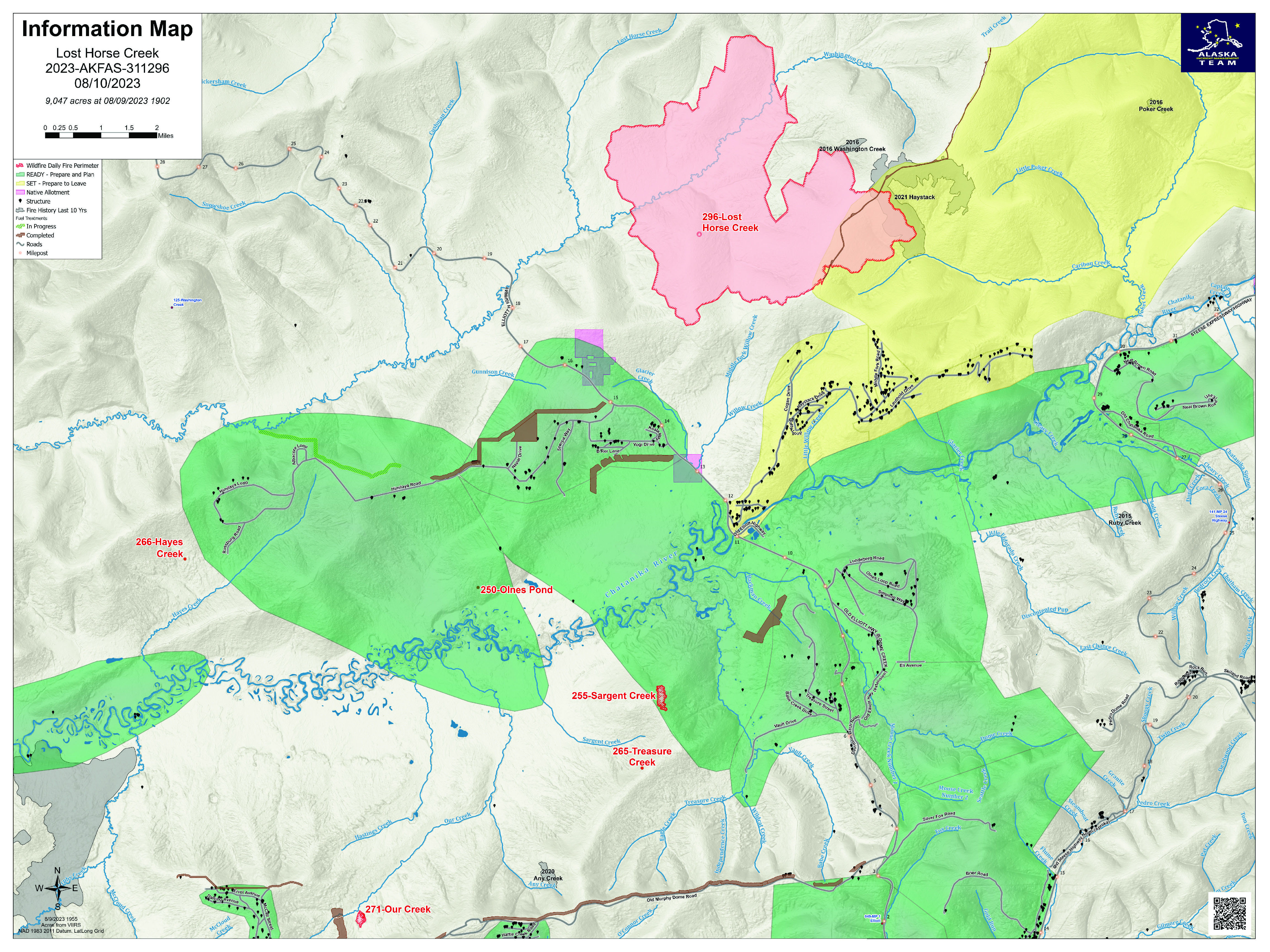
Lost Horse Creek Fire Update Thursday August 10 2023
Related Incident: Lost Horse Creek Fire
Publication Type: News
Lost Horse Creek Fire Update
August 10, 2023
Incident Commander: Peter Butteri
Start Date: July 28, 2023
Location: 22 miles N of Fairbanks, AK
Cause: Lightning/Natural
Fire Size: 9,047 acres
Containment: 0%
Total Personnel: 285
(Fairbanks, AK) – Firefighters on the Lost Horse Creek Fire (#296) are making good progress to secure the southern edge of the fire. Crews are mopping up the southeast side of the fireline and going direct on the southwest edge. Masticators have made it all the way to the Elliot Highway as they open up the old fuel break and continue to strengthen that. Structure assessment has been completed along the Elliot Highway. Structure protection continues on Upper Haystack, Middle Fork Road, and Lower Haystack. Work to build contingency lines continues.
Recent fire behavior has been moderate to minimal with some single tree torching. The weather pattern is shifting again to a warming and drying pattern with possible lightning strikes.
The Sargent Creek Fire (#255) and Our Creek Fire (#271) are in the final stages of mop up; the fires at Murphy Creek (#320), Treasure Creek (#265), Olnes Pond (#250) and Hayes Creek (#266) are in monitor status.
EVACUATIONS: As of Monday, August 7, the evacuation status for Upper Haystack changed from Level 3 (GO) to Level 2 (SET). Residents who evacuated the area may return to their homes. All other roads in the Haystack subdivision remain at Level 2 (SET). Although conditions are improving in the area, there is still a potential threat. Residents are advised to remain vigilant and be prepared to evacuate if necessary. For more information: Fairbanks North Star Borough, AK | Official Website (fnsb.gov); Find My Neighborhood (arcgis.com)
CLOSURES: Alaska State Parks has closed the Olnes Pond campground to support fire operations. The Bureau of Land Management Eastern Interior Field Office issued an evacuation and closure order for the western portion of the White Mountains National Recreation Area effective midnight on August 6 until September 1, unless modified. The evacuation and closure include trails, public use cabins, trail shelters, and the Wickersham Dome Trailhead near Elliott Highway mile 28, which may be used by firefighters. See: Alaska Fire Restrictions | Bureau of Land Management (blm.gov).
AIR QUALITY ADVISORY: The Tanana River Valley and areas north will continue to experience smoke from fires in Alaska and Canada. Any community adjacent to an active fire may experience periods of degraded air quality. Take measures to limit time outdoors and reduce your exposure to hazardous air quality. For smoke forecast and air quality measures, see Fire and Smoke Map (airnow.gov).
TEMPORARY FLIGHT RESTRICTIONS (TFR) are in effect until September 9, 2023. For details, see: 3/0799 NOTAM Details (faa.gov).
Public Information: (907) 921- 2555
Media Inquiries: (907) 921- 2554
Email: 2023.LostHorseCreek@firenet.gov
You Tube: Lost Horse Creek Fire #296 - YouTube
www.akfireinfo.com
www.facebook.com/AK.Forestry
https://inciweb.wildfire.gov
Inperson Community Meeting in Oakridge August 10 2023
Related Incident: Bedrock Fire
Publication Type: Announcement
In-person community meeting in Oakridge, Thursday, August 10 at 6:00 pm in the Oakridge High School Auditorium.
Hear from Operations, Incident Meteorologist, Incident Commander, Agency Administrators and Lane County for both the Bedrock and Salmon Fires. There will be an opportunity to ask questions of presenters after the presentation.
Please join us!
Sourdough Fire Update August 10 2023
Related Incident:
Publication Type: News
Resources: 418 Total Personnel | 9 Hand Crews | 27 Engines | 5 Water Tenders | 6 Helicopters
(Newhalem, Wash.) -- The Sourdough Fire started with a lightning strike on July 29 near Diablo in the steep and rugged terrain of Ross Lake National Recreation Area, 7 miles northeast of Newhalem. The speed limit has been reduced from 50 mph to 35 mph along State Route 20/North Cascades Highway from milepost 120 in Newhalem to milepost 156 just west of Rainy Pass for firefighter and public safety.
Yesterday: Widespread light showers, cooler temperatures, and elevated relative humidity kept fire behavior minimal across all flanks of the Sourdough Fire. These weather conditions allowed crews to make significant progress mopping up and securing line around the structures in the Diablo community, strengthening the work firefighters have focused on for days. Chipping operations occurred along Diablo Dam Road, removing fuels in the area and widening the control line. Crews chipped along the powerline corridor, improving firefighter access to suppress the fire. Fire activity in Sourdough Creek continues to be monitored. Firefighters worked to improve the control line from North Cascades Environmental Learning Center to Ross Dam. Due to weather and low-lying clouds, aircraft were unable to fly and support backhaul missions around Ross Lake. Backhaul is the process of removing equipment no longer needed from the fire area.
Today: Firefighters will monitor the fire as it moves towards Diablo, picking up rolling logs and danger trees that fall down the road so they can keep it open. They will also use a thermal imaging infrared camera around the structures in Diablo to pick up and mitigate any heat sources. Crews, through close coordination with Seattle City Light, will continue prepping the line along the powerline corridor. Once the clouds and inversion lift, aviation will support backhaul operations. Fire crews will work around the powerline on State Route 20 near Gorge Lake to prepare for future operations.
Weather: Cooler temperatures and higher humidity is forecast for today. These conditions will bring minimal fire behavior and growth to the entire perimeter of the fire. Any new growth will be slope and terrain driven. As clouds lift and winds pick up in the afternoon, air quality will continue to improve through today due to reduced fire activity.
This is a no-drone zone. Unmanned aerial systems (UAS) pose serious risks to firefighter and public safety and the effectiveness of wildfire suppression operations. Aerial firefighting is suspended when unauthorized UAS are in the area, allowing wildfire to grow larger.
Safety: Recreate responsibly; although the cause of this fire was a lightning strike, the vast majority of wildland fires are caused by humans. Be aware of outdoor burning restrictions where you are and use great care with all ignition resources.
Smoke: Smoke from the Sourdough Fire may affect communities around the region. Information about current conditions and a smoke forecast is located at: https://wasmoke.blogspot.com.
Closures and Evacuations: Evacuations are in effect for the North Cascades Environmental Learning Center and the community of Diablo. Trail, area and camp closures are in effect; for more information, go to: https://www.nps.gov/noca/planyourvisit/fire-closures.htm
Inperson Community Meeting in Oakridge August 10 2023
Related Incident: Salmon Fire
Publication Type: Announcement
In-person community meeting in Oakridge, Thursday, August 10 at 6:00 pm in the Oakridge High School Auditorium.
Hear from Operations, Incident Meteorologist, Incident Commander, Agency Administrators and Lane County for both the Bedrock and Salmon Fires. There will be an opportunity to ask questions of presenters after the presentation.
Please join us.