
Tin Soldier Complex Daily Update August 11th 2023
Related Incident:
Publication Type: News
SUMMARY
The Tin Soldier Complex is estimated at 2,632 acres in size and remains 0% contained. There was no IR flight last night therefore an update on acreage is not available at this time.
Acres burned as of the morning of Friday, August 11th.
- Bruce Fire – 993 acres at 0% containment
- Kah Mtn Fire – 430 acres at 0% containment
- Sullivan Fire – 1,209 acres at 0% containment
- Con Kelly Fire – 0.25 acres – Out.
The Bruce, Kah and Sullivan fires are being managed with point source protection to protect values at risk. Values at risk include Stony Communications Site, hydro-electric plant, Heinrude residential community, commercial guest ranches and the Spotted Bear Ranger Station compound.
PAST AND PLANNED ACTIONS
Today’s actions will include ongoing structure protection efforts for the Spotted Bear Ranch, Diamond R Ranch, Spotted Bear Ranger Station compound, and the Heinrude residential community. Mechanical equipment will complete the fuel break to the south and continue re-establishing the fuel break to the north end in the area around the community. Additionally, fire personnel have finished laying in hose line and sprinklers around structures within the Heinrude community. A crew will resume work to wrap the Spotted Bear Lookout.
EVACUATIONS, CLOSURES AND RESTRICTIONS
Evacuation: An evacuation has been issued by the Flathead County Sheriff for Heinrude community.
Restrictions/Closures:
- Stage 2 fire restrictions are in effect as of August 5th.
- An area closure is in effect for the Hungry Horse Reservoir, the front country of the Spotted Bear district as well the Gorge Creek drainage within the Bob Marshall Wilderness area, including Feather, Inspiration, Gorge, Canyon Trickle, and Stadium Creeks.
- A Temporary Flight Restriction is in place for air space over the Tin Soldier Complex to provide a safe environment for firefighting aircraft operating in the area. This includes the Spotted Bear and Meadow Creek Airstrips! Remember that temporary flight restrictions also apply to UAS or drones. If you fly, we can’t!
WEATHER
Today is forecasted to be mostly sunny with temperatures in the mid 70’s and relative humidities in the mid 20’s. West winds will develop again this afternoon but are not anticipated to be as strong as yesterday. A warming and drying trend will continue into early next week.
FIRE PREVENTION MESSAGE
The following acts are prohibited until further notice due to Stage 2 Fire Restrictions:
- Building and maintaining a fire, including charcoal fires. Propane with an on and off switch only.
- Operating or using any internal or external combustion engines without a spark arresting device properly installed. Cannot operate internal combustion engines from 1:00 pm to 1:00 am. Must have fire extinguisher or water, and a shovel with you at all times.
- Driving off designated roads and/or parking in vegetation.
- Smoking, except within an enclosed vehicle or building, a developed recreation site, or while stopped in an area at least three feet in diameter that is barren.
To get current info on restrictions, current fire info, smoke, and preparedness, visit www.mtfireinfo.org
Elkhorn Fire Daily Update August 11 2023
Related Incident: Elkhorn Fire
Publication Type: News
McCall, Idaho – Warm sunny skies gave way to an early inversion lift over the Elkhorn Fire yesterday morning allowing reconnaissance flights to gain a better view of containment, increasing it to 36% and the acreage to 25,964. A ridge of high pressure has moved into the region resulting in an increase in temperatures and decreased humidity levels.
Crews will continue to work the western flank of the fire in Trout Creek and maintain a presence around the inholdings along the Salmon River Corridor. Structure protection continues in Mallard Creek and Cook Ranch. Heavy equipment and fire crews progress with building indirect confinement lines around the Magruder corridor, 9505 C trail, 9550 road, 9560 road, 421 road and the 505 UT trail. Further up-river, Artic Point, River of No Return and Forest Service bridge infrastructures will receive further structure preparation.
Rafters can expect to see an increase of smoke in the Salmon River basin. Smoke monitoring equipment is being strategically placed throughout the area to monitor the air quality. The daily air quality reports will be available through the Elkhorn Fire information page at https://inciweb.nwcg.gov/incident-information/idpaf-elkhorn-fire.
The U.S. Forest Service Nez Perce-Clearwater, and Payette National Forests issued the Elkhorn fire area, roads and trails closure order #01-17-05-23-003, https://www.fs.usda.gov/alerts/nezperceclearwater/alerts-notices/?aid=82169. The closure area spans both sides of the Salmon River but excludes the Salmon River Wild and Scenic Corridor below the high-water line.
Boaters are required to stop at Hancock Campsite at river mile 26.1 to receive further instruction from either a Forest Service representative or the posted information board regarding passing through and camping in the area of the Elkhorn fire. Camping, recreating (i.e., picnic, bathroom breaks and beach walking) and stopping through the area of fire activity is allowed. Upon leaving Hancock Camp there will be no stopping until boaters pass Magpie Creek Camp. After passing Magpie Creek Camp, boaters will be allowed to camp and recreate on a First Come, First Served basis everywhere except: Upper Allison, Allison, Lower Allison, Whitewater Camp, Campbell’s Ferry and China Bar. Upon leaving China Bar, there are no camping restrictions connected to the Elkhorn Fire. For additional information on rafting, contact the river desk at 208-756-5587 or 208-481-2625.
A Temporary Flight Restriction (TFR) is in place. All aircraft (including drones) not assigned to the fire are required to remain out of the TFR area.
Visit InciWeb for information on wildfires at https://inciweb.ncwg.gov and follow the Payette National Forest on Facebook at https://www.facebook.com/payettenationalforest
###
Ridge Fire Daily Update August 11 2023
Related Incident:
Publication Type: News
Ridge Fire Daily Update for August 11, 2023
Fire Information: 406-998-6074
Hours: 8:00 AM – 7:00 PM
Email: 2023.ridge@firenet.gov
Incident Website: http://inciweb.wildfire.gov/incident-information/mtfnf-ridge-fire
Location: 6 miles southeast of Hungry Horse
Size: 2,940 acres
Percent Contained: 1 %
Cause: Lightning
Start Date: July 30, 2023, 3:45 PM
Vegetation: Timber (Litter and Understory), Tall Grass, and Brush
Number of Personnel Assigned: 325
CURRENT SITUATION: Yesterday, at the southern edge of the fire near Emery Creek crews mopped up along the roadway and continued direct handline up to the 1616 Road. Additional handline was constructed connecting the road system, and a proposed dozer line will continue to the 38 Road. At the northwest corner two Hotshot Crews scouted the area and developed a plan to go direct on the fire’s edge and continue handline to the south. To the north resources scouted the area for potential opportunities, and on the eastern side aviation resources were utilized to keep the fire in its current footprint.
Today, crews will continue direct line from the south to the 590E Road and construct direct line on the west side of the fire to Desert Mountain Ridge. A plan will also be developed for the possibility of strategic low intensity firing operations where needed to safely connect area of the fireline. Structure protection assessments continue and are coordinated with the local agencies.
The areas where firefighters have been able work directly on the fire’s edge have largely been the result of the fuel treatments strategically placed that have been effective in reducing the fire’s intensity and spread.
WEATHER: Today’s weather is forecast to be mostly sunny with a maximum temperature of 80-85 degrees, minimum relative humidity 21-26% at lower elevations, and 20 ft winds west 6-12 mph with afternoon gusts around 16 mph.
CLOSURES: The Hungry Horse Reservoir is closed to all public access, including both the east and west side roads. As firefighting efforts continue on the Ridge Fire, the Tin Soldier Complex, and other fires in the area, the closure is in place to provide for public and firefighter safety. https://www.fs.usda.gov/alerts/flathead/alerts-notices/?aid=82283
PRE-EVACUATION NOTICE: The Flathead County Sheriff’s Office has issued a pre-evacuation notice from the east side of Spotted Bear Road to West Glacier. https://www.facebook.com/flatheadsheriff
EMERGENCY SHELTER: The American Red Cross has identified the following location as an emergency shelter for residents affected by the Ridge Fire. Those who plan to use the emergency shelter are asked to call 1-800-733-2767 prior to your arrival.
Columbia Falls Junior High School
1805 Talbot Road
Columbia Falls, MT
https://www.facebook.com/FlatheadOES
ADDITIONAL INFORMATION: Residents should stay alert for changing conditions and visit ready.gov/wildfires for preparing for wildfires. Please refer to http://inciweb.wildfire.gov/incident-information/mtfnf-tin-soldier-complex for the Tin Soldier Complex incident information.
Smoke Outlook August 1112
Related Incident: Lowline Fire
Publication Type: News
Special Statement
|| Lowline Fire
Fire
The Lowline wildfire is currently at 1,871 acres and 55% containment.
Smoke
We will have GOOD air quality in the Gunnison area today with the overnight precipitation and cloud cover. Continuing into tomorrow with cooler temperatures and possible afternoon rain again in the forecast. Possible haze in the area with west winds clearing out in the afternoon. Almont and HWY 135 east of the fire will have GOOD air quality today as west winds increase and low fire activity continues. Crested Butte will continue to see GOOD air quality throughout the day.
Hayden Fire Update August 11 2023
Related Incident:
Publication Type: News
As the weather on the Hayden Fire transitioned from cool and rainy to more average temperatures and wind gusts of 25-30 mph Thursday, firefighters watched for signs of smoke or flare-ups throughout the fire’s footprint. Fire behavior Analyst Dan O’Connor said the winds presented an opportunity to test the integrity of containment lines. By shift’s end, O’Connor’s travels around the fire left him encouraged with the progress that has been made to date.
Crews on the ground continue to address pockets of heat and repair impacts from suppression activities. Nearly 20 miles of dozer line and 8 ½ miles of hand line were constructed to contain the fire. And while bare earth is desirable for stopping a fire’s progress, these lines can be scars on the landscape in the years following a fire event. On the Hayden Fire, these scars are being minimalized as heavy equipment and hand crews work together to de-compact and bring soil and other organic matter over the fire breaks.
Great Basin Team 4 Incident Commander Brad Sawyer commented, “We are getting where we need to be with this fire.”
Some resources, including helicopters, are being released to respond to other blazes in the region. Work on the Hayden Fire is 84% complete and is staffed with 347 firefighting and ground support personnel.
Clear skies enabled infrared imagery to be captured last night for the first time in more than a week. The acreage has been adjusted slightly downward as a result of this more accurate mapping.
Evacuations: The Lemhi County Sheriff’s Office, in coordination with the local agencies and Incident Management Team, has identified evacuation zones. Please visit the Lemhi County at www.lemhicountyidaho.org for a map and explanation of the zones.
Smoke: A smoke outlook specific to the Hayden Fire can be found at www.bit.ly/haydensmoke.
Closures: For the safety of firefighters and the public, the Salmon-Challis National Forest has enacted an area closure around the Hayden Fire. A map and description of the closure area can be found at https://inciweb.wildfire.gov/incident-closures/idscf-hayden-fire.
Fire Restrictions: Stage 1 Fire Restrictions are in effect on the Salmon-Challis National Forest, Idaho Department of Lands, and Bureau of Land Management jurisdiction. For more information, please visit the Salmon-Challis National Forest’s Alerts and Notices, https://www.fs.usda.gov/alerts/scnf/alerts-notices.
Gunnison National Forest Closure Order and Map as of August 11 2023
Related Incident: Lowline Fire
Publication Type: Closures
Order Number: GMUG-2023-08
U.S. Department of Agriculture, U.S. Forest Service
Gunnison National Forest
Gunnison Ranger District
Lowline Fire Area, Road and Trail Closure Update
PROHIBITIONS
Pursuant to 16 U.S.C. § 551 and 36 C.F.R. § 261.50 (a) and (b), the following are prohibited on the National Forest System (NFS) lands, roads and trails in the Gunnison
Ranger District, Gunnison National Forest, described below and shown on the attached map incorporated into this Order as Exhibit A (the “Described Area, Roads and Trails:
1) Going into or being upon the Described Area. 36 C.F.R. § § 261.52(e).
2) Being on the Described Roads. 36 C.F.R. § 261.54(e).
3) Being on the Described Trails. 36 C.F.R. § 261.55(a).
EXEMPTIONS
Pursuant to 36 C.F.R. § 261.50(e), the following persons are exempt from this Order:
1. Persons with Forest Service Permit No. FS-7700-48 (Permit for Use of Roads, Trails, or Areas Restricted by Regulation or Order), specifically exempting them from this Order or a written determination by a Forest Service authorized officer that a permit is not required under 36 C.F.R. § 251.50(e)(1) or (2).
2. Any Federal, State, or Local Officer, or member of an organized rescue or firefighting resource in the performance of an official duty.
DESCRIBED AREA, ROAD AND TRAIL
The Described Area includes National Forest System lands bordered on the northwest by the Mill-Castle Trail 450 from Storm Pass to the three-way junction of Trails 450,425, and 438; then bordered on the northeast edge by the Lowline Trail 438 to the top of Section 16 Township 15 South, Range 87 West 6th Principal Meridian; the northern boundary goes due east, following the top of Sections 16, 15, and 14 to the forest boundary; the eastern boundary follows the forest boundary to National Forest System Road 727; the south is bound by Road 727 and Trail 450 until it reaches Storm Pass. The Described Roads and Trails includes all roads and trails within the Described Area, including National Forest System Trails (NFST) Low Line Trail 438 and Mill-Castle Trail 450.
PURPOSE
The purpose of this Order is to provide for public safety and prevent interference with firefighting operations.
IMPLEMENTATION
1. This Order shall be in effect through December 31, 2023, at 12:00 p.m., unless rescinded.
2. A map identifying the Described Area, Roads and Trails is attached and made part of this Order as Exhibit A. For a digital version of this Order and Exhibit A, go to https://www.fs.usda.gov/alerts/gmug/alerts-notices.
3. Unless otherwise expressly defined in this Order, the terms used in this Order are defined by the regulations of the Secretary of Agriculture, 36 C.F.R. Chapter II, Parts 200-299. If there are terms in this Order that are not expressly defined in the Order or 36 C.F.R. Chapter II, Parts 200-299, their meaning shall be determined by their plain language definitions.
4. A violation of the above prohibitions is punishable as a Class B misdemeanor by a fine of not more than $5,000 for individuals and $10,000 for organizations, or by
imprisonment for not more than six months, or both. 16 U.S.C. § 551; 18 U.S.C. § 3559, 3571, and 3581.
5. Contact the Gunnison Ranger District in Gunnison, Colorado, at 970-641-0471 and Grand Mesa, Uncompahgre and Gunnison National Forest Supervisor’s Office in Delta, Colorado, at 970-874-6600, for more information about this Order.
6. This Order supersedes GMUG-2023-07 prohibiting the same or similar acts in the vicinity of the Lowline fire.
Signed and issued on August 10, 2023.
CHAD STEWART
Digitally signed by Chad Stewart
Date: 2023.08.10
Forest Supervisor
Grand Mesa, Uncompahgre & Gunnison National Forests
Brady Fire Incident Update for Thursday August 10 2023
Related Incident:
Publication Type: News
Today’s Date: 08/10/2023
Start Date: 08/06/2023 Location: 7 mi. E of Pine Cause: Unknown, under investigation
Acres – 279 Containment – 0%
Evacuations – None
Structures Damaged – 0 Destroyed – 0
Summary: As crews continue to make good progress with suppression efforts, today the SET statuses for Camp Geronimo and Shadow Rim scout camps were lifted. Once again, hand crews stayed engaged on the southeast corner of the fire and started removing hazard trees within the Washington Park and Verde Glen areas. All structure protection work in that area has been completed, including within Shadow Rim Camp and Forest Road 32. Ongoing efforts to clean up and strengthen hand lines continued today on the south and west sides of the fire. Crews also checked for any heating remaining along the containment lines. On the north side, resources started a chipping operation off Forest Road 300 to help clean up hand line along the edge of the Mogollon Rim. A recent Infrared (IR) flight showed some heat still within the interior of the fire along the north, southeast, and southwest sides, but overall fire activity has significantly decreased. A helicopter is assigned to the incident and will be used if necessary for bucket work to help suppress lingering hotspots. On Wednesday, a new start was reported to the north and west of Washington Park. The High View Fire is estimated at less than one acre and is located in inaccessible terrain. It is currently being monitored by Brady Fire resources. An Initial Attack (IA) group was also established on Thursday to assist with any new starts in the area due to lightning associated with potential thunderstorms. While the fire did not receive any moisture today, outflow winds could impact the fire area and potentially stir up activity. A 50% chance of precipitation is forecast for the weekend. The Coconino and Tonto National Forests’ Emergency Closure Order for the Brady Fire remains in effect through September 7, 2023, at 6:00 pm, unless rescinded. On Thursday morning, the Central West Zone Type 3 Incident Management Team (IMT) took command of the Brady Fire.
Personnel Assigned: 389: Hotshot Crews – 3, Type 2-IA hand crews – 3, Type 2 hand crews – 5, engines – 14, water tenders – 1, dozers – 7, helicopters – 3.
Weather: Hot and windy conditions. Outflow winds and lightning associated with possible thunderstorms.
Additional Fire Information:
Twitter: https://twitter.com/azstateforestry
Facebook: https://www.facebook.com/arizonaforestry
Fire Restrictions: wildlandfire.az.gov
Forest Closure Order Information: https://www.fs.usda.gov/tonto
Media/Public Phone: 602-540-1036
Aug 10 2023 Update
Related Incident: American Mesa Fire
Publication Type: News
TAOS, N.M., Aug. 10, 2023 – Despite sunny, warm conditions over the fire area, the American Mesa Fire continues to hold at 756 acres and is 35% contained. The wildfire is 15 miles southwest of Dulce.
“We received some isolated torching of juniper trees,” said Operations Planning Chief Jay Bertek on August 9, “But nothing escaped the line. Crews are making good progress securing hose lays and protecting the fire line edge.”
Crews are monitoring the fire and look to take advantage of direct attack strategies where opportunities allow. There are no immediate threats to structures. Two helicopters were used today to secure hotspots along the fire's edge. An Infrared (IR) Flight is scheduled for August 10th to identify other hotspots within the fire perimeter that need to be worked.
The forecast for Thursday calls for partly cloudy skies with a 40% chance of showers and thunderstorms in the afternoon. Temperatures may be cooler with breezy conditions and gusty and erratic winds expected near thunderstorms in the afternoon. Unless significant activity changes, American Mesa Fire Updates will be posted every other day.
The public can get updates for the American Mesa Fire on InciWeb, New Mexico Fire Information and Carson National Forest social media channels on Facebook and X (formerly Twitter).
Craft Fire Final Update August 10 2023
Related Incident: Craft Fire
Publication Type: News
Craft Fire
News - 08/10/2023
Craft Fire Final Update
August 10, 2023
8:00 PM
Size: 1,112 acres
Containment: 100%
Start Date: August 8, 2023
Cause: Unknown
At 6:00 pm on August 8, Texas A&M Forest Service received a request for assistance for a fire off of HWY 59 10 miles northeast of Jacksboro in Jack County.
Texas A&M Forest Service crews completed all containment lines and mop up operations, any fire activity was mitigated and the Craft Fire reached 100% containment by the end of the operational shift today.
Evacuations:
Local residents voluntarily evacuated, but have since been able to return.
Closures:
HWY 59 was closed down during initial attack but has been lifted.
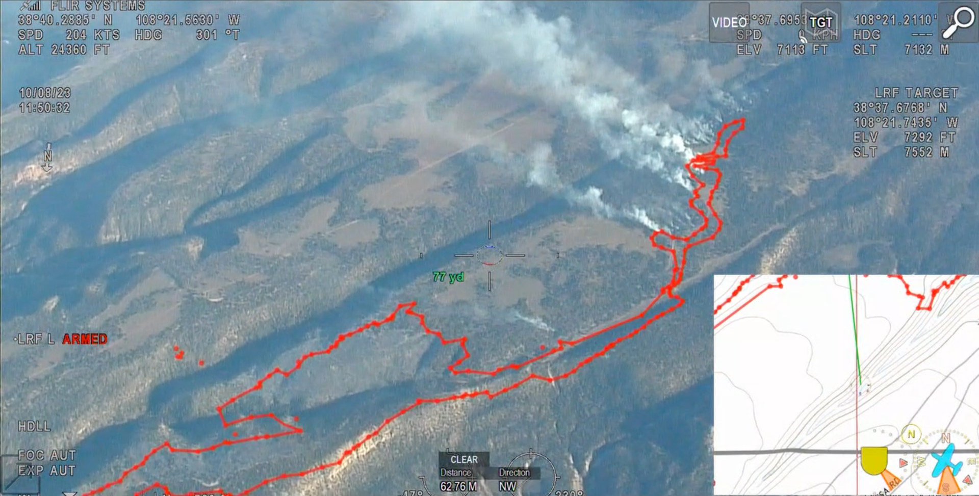
Little Mesa Fire Update August 10 2023 8PM
Related Incident: Little Mesa Fire
Publication Type: News
Crews spent today cleaning up unburnt fuel on the west side in Division A and finalized the aerial firing plan in Division Z. They observed active fire behavior with group torching and some short-range spotting into the canyon. All spots were able to be contained.
---
Photo Credit: Colorado Division of Fire Prevention and Control's Multimission Aircraft
(Colorado's Multi-Mission Aircraft (MMA) program is comprised of two Pilatus PC-12 airplanes outfitted with state-of-the-art infrared (IR) and color sensors (EO) operated by sensor operators from the DFPC Wildland Fire Management Staff. The PC-12 is a high performance turbo-prop aircraft that can cruise and work safely at altitudes above 20,000 feet. Based out of Centennial, CO the PC-12 can takeoff and be over a wildland fire almost anywhere in Colorado in less than an hour.)