
Publication Type: News
Big Knife, Niarada, & Mill Pocket Fires Daily Update
August 12, 2023
Confederated Salish and Kootenai Tribes
Fire Information: 406-426-9595 | 2023.BigKnife@firenet.gov
https://tinyurl.com/BigKnifeFire
https://tinyurl.com/NiaradaMillPocketFires
Location: Big Knife - 5 miles east of Arlee, MT | Niarada - 12 miles west of Elmo, MT | Mill Pocket: 3 miles West of Hwy. 28
Start Date: Big Knife - 7/24/2023 | Niarada - 7/30/2023 | Mill Pocket – 7/30/2023 Cause: Lightning Structures Lost: 4
Big Knife-4,952 acres, 7% contained | Niarada–20,365 acres, 59% contained | Mill Pocket– 2,135 acres, 66% contained
Total Personnel: 708 total Engines: 46 Aircraft: 1 + others available as needed Hand Crews: 16
Big Knife Fire
The warming and drying trend over the Big Knife Fire resulted in smoldering fuels in lower to mid-elevations burning more actively again. Aircraft are aiding firefighters as conditions allow, and helicopters dropped water on hot spots in the Agency Creek, Jocko Canyon, and Big Knife Creek drainages Friday. Firefighters have completed line preparation and vegetation reduction along Jocko Canyon/Canal Road. Equipment operators and crews completed control lines along the fire's southwestern edge to Agency Creek. They will continue working southward if the fire moves in that direction. On the fire's eastern side, crews began performing structure and point protection measures in South Fork Jocko River. Some measures included strategically wrapping Jocko Lookout and placing pumps and sprinklers around other resource values at risk. A specialized assessment team continues evaluating the long-term potential fire growth of the Big Knife Fire.
Niarada Fire & Mill Pocket Fire
Firefighters working on the Niarada Fire are pushing hard toward containment, and much of the fire's northern and western perimeter is now in mop-up and patrol status. Crews along the eastern and southeastern fire perimeter continue progressing, building more direct lines and working off the fire's black edge. Some indirect line will remain the only viable option around the fire's southerly perimeter, where terrain is treacherous and fuels are heavy. Strategic firing operations will likely be necessary during favorable conditions to secure those portions of indirect line. Specialized crews of skilled sawyers continued cutting fire-killed snags (dead-standing trees) south of Highway 28, enabling safe access for hand crews to previously hazardous areas. Structure protection crews continue to work outside Elmo towards Big Arm. Due to current conditions and progress, a night shift is no longer deemed necessary; however, it could be reinstated if conditions change.
Much of Mill Pocket Fire is in mop-up and patrol status. However, with the support of helicopters dropping water, crews are still working along the fire's northwestern perimeter near Mill Creek, in steep scree slopes, mopping up hot spots that are accessible.
WEATHER AND FIRE BEHAVIOR
High pressure is building over the fire areas, bringing warmer temperatures and progressively lower relative humidity as the weekend passes. As humidity drops and fuel moistures return to levels observed before last week’s storms, heavy fuels that have been smoldering are returning to life. Fire activity and behavior will likely increase through the coming week.
CLOSURES AND SPECIAL MESSAGES
The Lake County Sheriff has placed several areas near the base of the mountains west of the Big Knife Fire in PRE-EVACUATION status. See the map for those locations in yellow (Jocko, Canal, Francis). In the Tribal Primitive Area, Belmore Slough and Burnt Cabin Roads are closed.
The Lake County Sheriff’s Office is downgrading those in EVACUATION status near the Niarada Fire in Lake County to a PRE-EVACUATION WARNING. This area includes Alexander Road, Early Dawn Road, Spring Lane Road, Walking Horse Lane, Windward Heights Road, Wildhorse View, Buffalo Bridge Road, Saddle Drive, Island Butte Lane, Bridle Path, Ten Deuce Way, Cliffview Drive, and Ricketts Road.
A PRE-EVACUATION WARNING means you may return to your home. However, as there is still a potential threat from the Niarada Fire, please do not bring back evacuated livestock until the area is downgraded to READY status. The remainder of the town of Elmo is in READY status.
A temporary flight restriction (TFR) is in effect around both fire areas. Do not fly unmanned aircraft (drones) near the fire areas, as that is hazardous for pilots, and the firefighters on the ground who rely on aircraft support. Remember, if you fly, we can’t!
Use extreme caution when driving on Highway 28. Firefighters and equipment are still working in the area.
FIRE RESTRICTIONS
Stage 2 fire restrictions are in place across the Flathead Indian Reservation. No campfires are allowed, no smoking outside of vehicles, no operating combustible engines between 1PM-1AM, no operating vehicles off designated roads and trails. Residents and visitors are encouraged to visit www.MTFireInfo.org for more fire information across Montana.
Cedar Top Fire
Related Incident: Cedar Top Fire
Publication Type: News
Cedar Top Fire
News - 08/12/2023
Cedar Top Fire Daily Update
August 12, 2023
Size: 2,308 acres
Containment: 90%
Start Date: August 9, 2023
Cause: Unknown
On August 9, around 2:00 p.m. Texas A&M Forest Service received a request for assistance on a fire burning approximately 15 miles northwest of Seymour, Texas in Knox County.
Crews made good progress yesterday with minimal fire activity, all containment lines have been constructed with engine crews continuing mop up operations to ensure the fire is completely out.
Evacuations:
None, due to the fire's remote location.
Monkey Creek Fire Update August 12 2023
Related Incident: Monkey Creek Fire
Publication Type: News
Monkey Creek Fire
News - 08/12/2023
Monkey Creek Fire Daily Update
August 12, 2023
Size: 2,200 acres
Containment: 35%
Start Date: August 8, 2023
Cause: Unknown
Around 6 p.m. on August 9, Texas A&M Forest Service received a request for assistance on a fire burning 8 miles South of Quanah in Hardeman County, Texas. The fire is burning in juniper shrub and grass fuels.
Yesterday Crews worked hard to keep the fire within the containment lines with several areas that began to slop over, aircraft made many binaficial drops, and dozer crews were quick to respond keeping the fire under control. Fire activity was very extreme yesterday with extreme heat and high winds. Crews have continued to make good progress increasing containment to 35%.
Evacuations:
Copper Breaks State Park
Elkhorn Fire Daily Update August 12 2023
Related Incident: Elkhorn Fire
Publication Type: News
McCall, Idaho – The Elkhorn Fire is currently at 25,961 acres with 36% complete. A weak cold front swept through Central Idaho today bringing both a slight increase in cloud cover with winds out of the northwest in the Salmon River corridor. As temperatures are forecasted to increase with lower relative humidity (RH). This will cause the fire to burn more readily where we have heat signatures on the landscape.
Wildland firefighters will continue containment efforts along the southwest flank of the fire in the Whitewater Wilderness Ranch area and will continue to protect the inholdings along the Salmon River corridor. Crews are also working near Mallard Creek, Cook Ranch, and the community of Dixie, building an indirect line along the 9550A road through Trapper’s Creek up to where the road turns into the 9560 road, continuing north to Magruder Road.
Two Heavy Equipment task forces on the north side of the fire continue to construct fuel breaks from the 9505 road to Magruder Road, where the indirect line will then follow the 505 UTV trail, tying into the Shissler fire scar from 2020.
With the forecasted rise in temperatures and drop in RH, rafters can expect to see an increase of smoke in the Salmon River basin. The daily air quality reports will be available through the Elkhorn Fire information page at https://inciweb.nwcg.gov/incident-information/idpaf-elkhorn-fire.
The U.S. Forest Service Nez Perce-Clearwater, and Payette National Forests issued the Elkhorn fire area, roads and trails closure order #01-17-05-23-003, https://www.fs.usda.gov/alerts/nezperceclearwater/alerts-notices/?aid=82169. The closure area spans both sides of the Salmon River but excludes the Salmon River Wild and Scenic Corridor below the high-water line.
Boaters are required to stop at Hancock Campsite at river mile 26.1 to receive further instruction from either a Forest Service representative or the posted information board regarding passing through and camping in the area of the Elkhorn fire. Camping, recreating (i.e., picnic, bathroom breaks and beach walking) and stopping through the area of fire activity is allowed. Upon leaving Hancock Camp there will be no stopping until boaters pass Magpie Creek Camp. After passing Magpie Creek Camp, boaters will be allowed to camp and recreate on a First Come, First Served basis everywhere except: Upper Allison, Allison, Lower Allison, Whitewater Camp, Campbell’s Ferry, and China Bar. Upon leaving China Bar, there are no camping restrictions connected to the Elkhorn Fire. For additional information on rafting, contact the river desk at 208-756-5587 or 208-481-2625.
A Temporary Flight Restriction (TFR) is in place. All aircraft (including drones) not assigned to the fire are required to remain out of the TFR area.
Visit InciWeb for information on wildfires at https://inciweb.ncwg.gov and follow the Payette National Forest on Facebook at https://www.facebook.com/payettenationalforest
Smoke Outlook August 1213
Related Incident: Lowline Fire
Publication Type: News
Today's post, August 12th-13th, will be the last post of the smoke outlook for the Lowlinefire.
Smoke Forecast Outlooks can be found at: https://outlooks.airfire.org/outlook
Fire
The Lowline wildfire is at 1,871 acres and 55% containment.
Smoke
With current weather systems moving into the area we will
see GOOD air quality in the forecast today. Some light
smoke in the central Gunnison early a.m. as weather / wind
push some smoke into the area drainages. Rain will
continue in the area over the weekend keeping smoke very
minimal in and around Gunnison. Almont and HWY 135 east
of the fire will have GOOD air quality today as west winds
increase and low fire activity continues. Crested Butte will
continue to see GOOD air quality throughout the weekend.
Hayden Fire Update August 12 2023
Related Incident:
Publication Type: News
Due to the successful actions of firefighters and moderated chance of fire growth, the Salmon-Challis National Forest reduced the Hayden Fire closure order in the Leadore and Challis-Yankee Fork Ranger districts. The temporary flight restriction that limited non-emergency aircraft and drones over the fire was lifted this morning.
Warm, dry, and breezy conditions will continue on Saturday. Full sun and gusty afternoon winds may increase smoke that is visible in the surrounding communities, however air quality is expected to remain good over the next several days. Temperatures are forecasted to climb Tuesday through Thursday with highs in the 80s.
There are scattered areas of heat in the Morse Creek and Cold Creek areas on the southwest side of the fire. Aerial and ground resources will be utilized to patrol fire activity and secure any hot spots throughout the fire area as necessary.
Suppression repair is moving forward, and crews have completed approximately 50% of the planned repairs on dozer and hand lines, and on roads that were utilized as direct and indirect containment lines.
Evacuations: The Lemhi County Sheriff’s Office, in coordination with the local agencies and Incident Management Team, has identified evacuation zones. All evacuation zones are currently in the ready status. Please visit Lemhi County at www.lemhicountyidaho.org for a map and explanation of the zones.
Smoke: A smoke outlook specific to the Hayden Fire can be found at www.bit.ly/haydensmoke.
Closures: For the safety of firefighters and the public, the Salmon-Challis National Forest has enacted an area closure around the Hayden Fire. A map and description of the closure area can be found at https://inciweb.wildfire.gov/incident-closures/idscf-hayden-fire.
Fire Restrictions: Stage 1 Fire Restrictions are in effect on the Salmon-Challis National Forest, Idaho Department of Lands, and Bureau of Land Management jurisdiction. For more information, please visit the Salmon-Challis National Forest’s Alerts and Notices at https://www.fs.usda.gov/alerts/scnf/alerts-notices.
Hayden Fire Closure Order 04132309 81123
Related Incident:
Publication Type: Closures
Order Number: # 04-13-23-09
U.S. Department of Agriculture, U.S. Forest Service
Salmon-Challis National Forest
Leadore and Challis-Yankee Fork Ranger Districts
Hayden Fire Closure Order #4
PROHIBITIONS
Pursuant to16 U.S.C. § 551 and 36 CFR 261.50(a) the following acts are prohibited on National Forest System (NFS) lands in the Leadore and Challis-Yankee Fork Ranger Districts, Salmon-Challis National Forest, shown on the attached map incorporated into this Order as Exhibit A (the “Described Area”):
1. Going into or being upon the Described Area, 36 C.F.R. § 261.52 (e).
EXEMPTIONS
Pursuant to 36 C.F.R. § 261.50(e), the following persons are exempt from this Order:
1. Persons with Forest Service Permit No. FS-7700-48 (Permit for Use of Roads, Trails, or Areas Restricted by Regulation or Order), specifically exempting them from this Order or a written determination by a Forest Service authorized officer that a permit is not required under 36 C.F.R. § 251.50(e)(1) or (2).
2. Any Federal, State, or local officer, or member of an organized rescue or fire fighting force in the performance of an official duty.
DESCRIBED AREA
NFS lands, roads, and trails on the Leadore and Challis-Yankee Fork Ranger Districts of the Salmon-Challis National Forest within the area bounded by the following: starting at the junction of the Salmon-Challis National Forest boundary and National Forest System Road (NFSR) #008 Hayden Creek Road, then following the Salmon-Challis National Forest boundary to the northwest to its junction with National Forest System Trail (NFST) #6178 Basin Creek Trail, then following NFST #6178 to where it joins the hydrologic divide between Basin Creek and Bear Valley Creek, then following this hydrologic divide west to the hydrologic divide between the Lemhi and Salmon River Valleys, then following the Lemhi/Salmon River hydrologic divide south over Lem Peak, Long Mountain, and May Mountain to the hydrologic divide between Tater Creek and Morse Creek, then following the hydrologic divide between Tater Creek and Morse Creek south to the Forest boundary, then following the Forest boundary southeast to its intersection with Falls Creek, then following Falls Creek northeast to its junction with an unnamed drainage in Township 15 North, Range 23 East, Section 14, then following this unnamed drainage north to the hydrologic divide between the Pahsimeroi and Lemhi Valleys, then following the Pahsimeroi/Lemhi divide south and east to its junction with the hydrologic divide between Mill Creek and Lee Creek, then following the Mill Creek/Lee Creek divide north to Lee Creek, then following Lee Creek northeast to its junction with the Forest boundary, then following the Forest boundary northwest to the point of origin at the junction of the Salmon-Challis National Forest boundary and NFSR #008 Hayden Creek Road.
PURPOSE
The purpose of this Order is to protect public health and safety from the effects of the Hayden Fire.
IMPLEMENTATION
1. This Order shall be in effect from August 11, 2023, at 12:00 through September 30th, 2023, at 12:00, unless rescinded.
2. A map identifying the Described Area, Roads and Trails is attached and made part of this Order as Exhibit A. For a digital version of this Order and Exhibit A, go to https://www.fs.usda.gov/alerts/r4/alerts-notices.
3. Unless otherwise expressly defined in this Order, the terms used in this Order are defined by the regulations of the Secretary of Agriculture, 36 C.F.R. Chapter II, Parts 200-299. If there are terms in this Order that are not expressly defined in the Order or 36 C.F.R. Chapter II, Parts 200-299, their meaning shall be determined by their plain language definitions.
4. A violation of the above prohibitions is punishable as a Class B misdemeanor by a fine of not more than $5,000 for individuals and $10,000 for organizations, or by imprisonment for not more than six months, or both. 16 U.S.C. § 551; 18 U.S.C. §§ 3559, 3571, and 3581.
5. Contact the Leadore Ranger District in Leadore, Idaho at (208) 768-2500, the Challis-Yankee Fork Ranger District in Challis, Idaho at (208) 879-4100, or the Salmon-Challis National Forest Supervisor’s Office in Salmon, Idaho at (208) 756-5100, for more information about this Order.
6. This Order supersedes any previous Orders prohibiting the same or similar acts in the same Described Area and Roads.
Signed and issued on August 11, 2023.
Brady Fire Incident Update for Wednesday August 9 2023
Related Incident:
Publication Type: News
Today’s Date: 08/09/2023
Start Date: 08/06/2023 Location: 7 mi. E of Pine Cause: Unknown, under investigation
Acres – 279 Containment – 0%
Evacuations – SET for Camp Geronimo and Shadow Rim Camp
Structures Damaged – 0 Destroyed – 0
Summary: The fire overall stayed quiet again today with the exception of the southeast side which has been active over the last 48 hours. However, a hotshot crew and Type 2-IA hand crew successfully established hand line along that flank of the fire today before being pulled off the line due to incoming, afternoon thunderstorms. Hand crews with the help of a dozer were also able to get line around structures in the Washington Park area, at Shadow Rim Camp, and along Forest Road 32. Work also continued to improve and strengthen existing fuel breaks in the area. The fuel breaks help safeguard communities and help slow, and often times stop a fire’s progression. Crews also worked to finish containment line on the south and west sides and strengthen line already constructed. A reconnaissance flight today reported a few smokes on the northwestern side and a helicopter was used to provide bucket work to help suppress those hotspots. On the north side, on the Mogollon Rim, crews strengthened and improved containment line after fire slopped over the line yesterday. Also on the north side, resources focused on prepping Forest Road 300 in the event the fire makes a push to the north and northwest. The proactive prep work allows crews to use the road as a control feature for firing operations to help suppress the fire. This morning’s aerial recon also assisted as a mapping mission. The GPS flight reported the fire at 279 acres. An Emergency Closure Order is now in effect for the fire area. The closure order, issued by the Coconino and Tonto National Forests, provides for public health and safety due to firefighting operations and fire danger associated with the Brady Fire on the two forests. In addition, Stage 1 fire restrictions remain in effect on Arizona State Trust lands and within the Tonto and Coconino National Forests. Under Stage 1 restrictions, campfires are allowed only within a designated and developed campsite. Tomorrow, the Department of Forestry and Fire Management (DFFM) and the Tonto National Forest transfer command of the fire to the Central West Zone Type 3 Incident Management Team.
Personnel Assigned: 295. Hotshot Crews – 2, Type 2-IA hand crews – 4, Type 2 hand crews – 3, engines – 16, water tenders – 1, dozers – 4, helicopters – 1
Weather: Hot and windy conditions. Outflow winds and lightning associated with possible thunderstorms.
Additional Fire Information:
Twitter: https://twitter.com/azstateforestry
Facebook: https://www.facebook.com/arizonaforestry
Fire Restrictions: wildlandfire.az.gov
Forest Closure Order Information: https://www.fs.usda.gov/tonto
Media/Public Phone: 602-540-1036
Brady Fire Incident Update for Friday August 11 2023
Related Incident:
Publication Type: News
Today’s Date: 08/11/2023
Start Date: 08/06/2023 Location: 7 mi. E of Pine Cause: Unknown, under investigation
Acres – 279 Containment – 0%
Evacuations – None
Structures Damaged – 0 Destroyed – 0
Summary: A second Infrared (IR) flight overnight found a reduction in some heat within the perimeter of the fire, but scattered hotspots still remain along the north and southeast sides. Those sides remain a priority for resources with a bulk of the suppression work taking place there. On the north side of the fire, off Forest Road 300, chipping operations to clean up remaining hazardous vegetation along containment line resumed today. The operation is expected to last through Saturday then resources will shift to the southeast side of the fire and tie in with crews there to finish hazard tree removal and containment line work within the Washington Park area. The fire has stayed within its footprint over the last few days and remains at 279 acres. Brady Fire resources are prepared to assist the Tonto National Forest as part of initial attack efforts for any new starts within the forest. An Incident Meteorologist assigned to the Brady Fire reports a 70% chance of rain through the weekend with a 50% chance of wetting rain, along with increased relative humidity levels. The Coconino and Tonto National Forests’ Emergency Closure Order for the Brady Fire remains in effect through September 7, 2023, at 6:00 pm, unless rescinded. Stage 1 fire restrictions are also still in place on Arizona State Trust lands and within the Coconino and Tonto National Forests.
Personnel Assigned: 360: Hotshot Crews – 3, Type 2-IA hand crews – 3, Type 2 hand crews – 5, engines – 11, dozers – 3, helicopters – 4.
Weather: Hot and windy conditions. Outflow winds and lightning associated with possible thunderstorms.
Additional Fire Information:
Twitter: https://twitter.com/azstateforestry
Facebook: https://www.facebook.com/arizonaforestry
Fire Restrictions: wildlandfire.az.gov
Forest Closure Order Information: https://www.fs.usda.gov/tonto
Media/Public Phone: 602-540-103
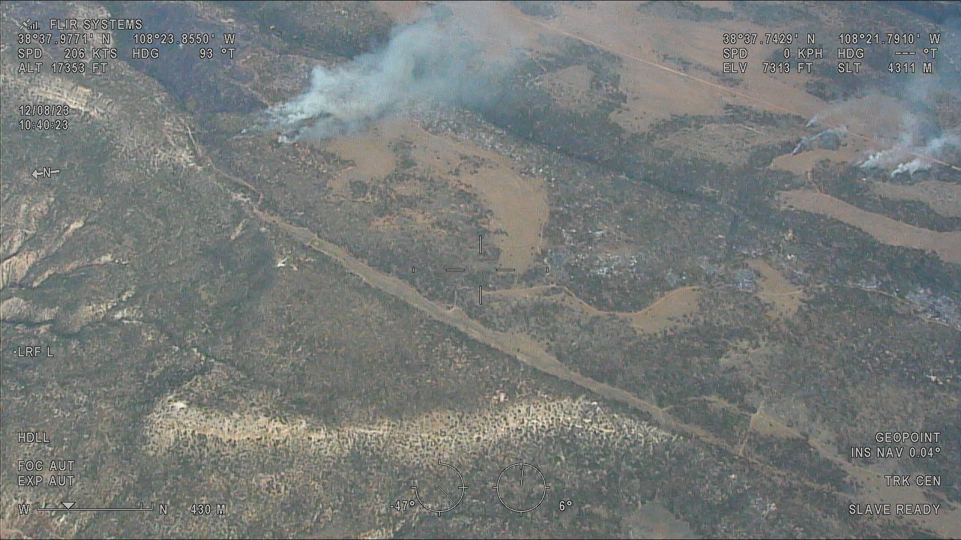
Little Mesa Fire Update August 11 2023 8PM
Related Incident: Little Mesa Fire
Publication Type: News
Fire activity was reduced more than expected by last night's precipitation and increased humidity. Firefighters held the line at Tatum Ridge Rd in Div A. Attempts were made to perform aerial ignitions using Unmanned Aircraft Systems in Div Z but conditions were too wet. Another attempt will be made when conditions permit.
Photo Credit: DFPC's Multi-Mission Aircraft