
Fire Update August 11
Related Incident: Quartz Ridge Fire
Publication Type: News
Fire start date: August 5, 2023
Fire size today: 1,298 acres
Containment: 0%
Location: 13 miles Northeast of Pagosa Springs, Colorado
Personnel: 60
Cause: Lightning
Management: Suppression
Evacuation Information:
There are no current evacuations. Local residents should follow incident information for updates.
Closures:
- Quartz Meadows Rd (NFSR#685)
- Quartz Ridge Trail (NFST#570)
- Quartz Creek Trail (NFST#571)
Latest Smoke Outlook:
https://outlooks.wildlandfiresmoke.net/outlook/933fc4e4
INCIDENT OBJECTIVES:
- Firefighter and Public safety will be the highest priority during this incident.
- To protect private lands within East Fork San Juan River drainage, critical infrastructure including powerlines and gas utility lines, as well as natural resources, cultural and historic sites, and recreation assets.
Fire behavior remained moderate yesterday thanks to cloud cover and higher relative humidity. Several days of cooler temperatures and higher humidity will slow the fire’s growth; however, this fact does not change the risk factors preventing firefighters from engaging the fire directly. The fire area in the South San Juan Wilderness is extremely steep and heavily loaded with dead timber both standing and down; this elevates the risk to firefighters and aviators. These risk factors also exist in the Quartz Creek drainage, preventing crews from engaging the spot fires that are now established on the east side of the creek. Aviation assets may be utilized to support ground firefighters in this area, along with aerial supervision as needed. A National Incident Management Organization Team will assume command of the incident August 12th at 0600, providing additional capacity and oversight.
YESTERDAY’S ACCOMPLISHMENTS:
- Ground crews assessed potential access to the spot fires on the east side of the fire, but determined access was too hazardous to hike crews in.
- Ground fire resources continued to directly monitor fire growth and directional spread. San Juan Type 3 incident Management Team (IMT) worked with local cooperators to develop long-term, strategic plans for fire suppression.
- Fire managers developed plans for when the fire reaches terrain more favorable for engagement.
TODAY’S PLAN:
- Crews will identify more structures and values at risk to the northeast of the fire, anticipating potential movement towards East Fork of the San Juan River.
- Crews will continue performing fire mitigation for exposed sections of the Xcel Energy gas pipeline, located to the north of the fire along Forest Road 667.
- Crews will be assessing alternate suppression options within Quartz Creek.
- IMT operational leadership will recon the fire area with aviation resources assigned to the fire, developing real-time situational awareness.
- Continue to develop Management Action Points, which are clearly specified incident conditions that, when reached, prompt a predefined fire management action or trigger the implementation of new strategies/tactics.
- Communicate with landowners, affected utilities, and county stakeholders.
WEATHER:
The weather trend includes increasing chances of rain showers. Gusty outflow winds and lightning that are the concerns for firefighters.
Road and Trail Closures on the Turkey Fire
Related Incident:
Publication Type: Closures
Order Number: # 03-06-07-23-001
U.S. Department of Agriculture, U.S. Forest Service Gila National Forest
Silver City Ranger District
TURKEY FIRE ROADS AND TRAILS CLOSURE
PROHIBITIONS
Pursuant to 16 U.S.C. § 551 and 36 C.F.R. § 261.50(b), the following is prohibited on the National Forest System (NFS) roads and trails on the Wilderness and Silver City Ranger Districts, Gila National Forest, described below and shown on the attached map and herby incorporated into this order on the attached map hereby incorporated into this Order as Exhibit A (the “Described Roads” and “Described Trails”):
- Being on the Described Roads 36 C.F.R. § 261.54(e).
- Being on Described Trails 36 C.F.R. § 261.55(a).
EXEMPTIONS
Pursuant to 36 C.F.R. § 261.50(e), the following persons are exempt from this Order:
- Persons with Forest Service Permit No. FS-7700-48 (Permit for Use of Roads, Trails, or Areas Restricted by Regulation or Order), specifically exempting them from this Order or a written determination by a Forest Service authorized officer that a permit is not required under 36 C.F.R. § 251.50(e)(1) or (2).
- Any Federal, State, or Local Officer, or member of an organized rescue or firefighting resource in the performance of an official duty.
DESCRIBED ROADS AND DESCRIBED TRAILS
The Described Roads are all of NFSR 282 and all of NFSR 876. The Described Trails are the entire length of the Goose Lake Trail #238 and Dorsey Canyon Trail #239.
PURPOSE
The purpose of this Order is to protect public health and safety from hazardous road and trail conditions stemming from fire suppression activities.
IMPLEMENTATION
- This Order shall be in effect from August 8, 2023 at 06:00 p.m. through December 31, 2023 at 11:30 p.m., unless rescinded.
- A map identifying the Described Road is attached and made part of this Order as Exhibit A. For a digital version of this Order and Exhibit A, go to https://www.fs.usda.gov/alerts/gila/alerts-notices Signs will be posted at both ends of the closed portion of the road.
- Unless otherwise expressly defined in this Order, the terms used in this Order are defined by the regulations of the Secretary of Agriculture, 36 C.F.R. Chapter II, Parts 200-299. If there are terms in this Order that are not expressly defined in the Order or 36 C.F.R. Chapter II, Parts 200-299, their meaning shall be determined by their plain language definitions.
- A violation of the above prohibition is punishable as a Class B misdemeanor by a fine of not more than $5,000 for individuals and $10,000 for organizations, or by imprisonment for not more than six months, or both. 16 U.S.C. § 551; 18 U.S.C.
§§ 3559, 3571, and 3581.
- Contact the Silver City Ranger District in Silver City, New Mexico (575) 388-8201, and Gila National Forest Supervisor’s Office in Silver City New Mexico, (575) 388- 8201, for more information about this Order.
- This Order supersedes any previous Orders prohibiting the same acts on the same Described Roads and Described Trails.
Signed and issued on August 8, 2023.
CAMILLE HOWES
Digitally signed by CAMILLE HOWES Date: 2023.08.08
12:31:05 -06'00'
Camille Howes Forest Supervisor Gila National Forest
Turkey Fire Road and Trail Closure - Order Number: 03-06-07-23-001, Exhibit A
Gila National Forest - Silver City Ranger District
Bedrock and Salmon Daily Fire Update August 11 2023
Related Incident: Bedrock FireSalmon Fire
Publication Type: News
Bedrock Fire: Heavy helicopters were active on the north end of the fire yesterday, flying water buckets to cool and slow fire growth. Firefighters on the northwestern portion of the fire are continuing to prepare control lines for burnout operations to secure these lines and are conducting these burnouts as weather conditions allow. Yesterday there was a visible smoke column from these burnout operations. There will continue to be visible smoke from the fire in the coming days as fire crews work along control lines, burning portions of line, then securing, tying together, and holding these lines as they add depth and strengthen containment lines around the northern fire perimeter. Firefighters on the southern fire perimeter are continuing to mop up where needed and are patrolling to identify and extinguish any remaining hot spots near control lines. Initial Attack resources have been identified and are ready to rapidly shift assignments if necessary to assist with new fire starts in the area.
Salmon Fire: Firefighters made excellent progress strengthening firelines and installing hoselays around the fire yesterday. This fire is smoldering and creeping along the ground and continues to remain within established control lines. Today fire crews will continue to secure and mop up around the fire perimeter and mitigate any roll out potential from burning fuels on the steep slopes.
Evacuations: The Lane County Sheriff's Office issued a Level 1 “Be Ready” evacuation notice Monday morning for areas north and east of Oakridge because of the Salmon Fire. Please heed all evacuation notices and orders. A searchable evacuation map with fire perimeters for both fires is available at https://lcgisorg.maps.arcgis.com/apps/webappviewer/index.html?id=32e4cd9a5c3348cd81254e6fa394e097. This online map has a ruler tool so the distance from the fires to various towns can be measured.
Smoke: Smoky conditions are predicted for Oakridge and eastward on Highway 58, peaking to unhealthy for sensitive groups midday before clearing this evening. Most areas will have good to moderate air quality today. Smoke in La Pine may reach unhealthy levels, improving to moderate this afternoon.
Weather: High pressure building through this weekend will lead to warmer temperatures and drier conditions. Predicted high temperatures today will be 83-89 degrees at lower elevations and 73-82 degrees on the ridgetops. West winds will be 4-7 mph this morning, gusting to 14 mph this afternoon.
Safety and Closures: The Willamette National Forest implemented the Bedrock Fire Emergency Area Closure on July 24 to ensure the safety of the public and personnel working on the fire. An emergency closure order for the Salmon Fire area is in place as of August 8. The closure maps for the Bedrock and Salmon Fires are available on InciWeb. There are Temporary Flight Restrictions over the Bedrock and Salmon Fire areas. Residential electrical outages can be reported to Lane Electric at 541-484-1151.
Facebook: https://www.facebook.com/BedrockFire2023/
Fire Information: (541) 414-6272, 8:00 AM – 8:00 PM
Email: 2023.bedrock@firenet.gov
Lost Horse Creek Fire Update Friday August 11 2023
Related Incident: Lost Horse Creek Fire
Publication Type: News
Lost Horse Creek Fire Update
August 11, 2023
Incident Commander: Peter Butteri
Start Date: July 28, 2023
Location: 22 miles N of Fairbanks, AK
Cause: Lightning/Natural
Fire Size: 9,505 acres
Containment: 12%
Total Personnel: 293
(Fairbanks, AK) – The southern edge of the Lost Horse Creek Fire (#296), approximately 8 miles of the fire perimeter (32%), are targeted for containment. Three miles (12%) are currently contained, that is, we are confident the fire will not cross that line. The strategy for the remainder of the fire is to confine it to a defined area that does not endanger people or structures. To do that, we continue to work on contingency line, away from the direct fire edge.
The eastern edge of the fire that is burning into the 2021 Haystack Fire scar remains active due to dead and down fuels that create pockets of fire and dangerous conditions for ground crews to access. The southwest edge of the fire is being worked directly by bulldozers, moving eastward along the fireline. Masticators have cleared the old fuel break west to the Elliot Highway and are continuing its improvement eastward. Structure protection is in place in the Haystack subdivision and graders are repairing the road.
The Sargent Creek Fire (#255) is 100% contained and in monitor status along with Murphy Creek (#320), Treasure Creek (#265), Olnes Pond (#250), and Hayes Creek (#266). Our Creek Fire (#271) is at approximately 80% containment and in mop-up status.
EVACUATIONS: The Haystack subdivision remains at a Level 2 (SET). Although conditions are improving in the area, there is still a potential threat. Residents are advised to remain vigilant and be prepared to evacuate if necessary. For more information: Fairbanks North Star Borough, AK | Official Website (fnsb.gov); Find My Neighborhood (arcgis.com)
CLOSURES: Alaska State Parks has closed the Olnes Pond campground to support fire operations. The Bureau of Land Management Eastern Interior Field Office issued an evacuation and closure order for the western portion of the White Mountains National Recreation Area effective midnight on August 6 until September 1, unless modified. The evacuation and closure include trails, public use cabins, trail shelters, and the Wickersham Dome Trailhead near Elliott Highway mile 28, which may be used by firefighters. See: Alaska Fire Restrictions | Bureau of Land Management (blm.gov).
AIR QUALITY ADVISORY: The Tanana River Valley and areas north will continue to experience smoke from fires in Alaska and Canada. Any community adjacent to an active fire may experience periods of degraded air quality. Take measures to limit time outdoors and reduce your exposure to hazardous air quality. For smoke forecast and air quality measures, see Fire and Smoke Map (airnow.gov).
TEMPORARY FLIGHT RESTRICTIONS (TFR) are in effect until September 9, 2023. For details, see: 3/0799 NOTAM Details (faa.gov).
Public Information: (907) 921- 2555
Media Inquiries: (907) 921- 2554
Email: 2023.LostHorseCreek@firenet.gov
You Tube: Lost Horse Creek Fire #296 - YouTube
www.akfireinfo.com
www.facebook.com/AK.Forestry
https://inciweb.wildfire.gov
Sourdough Fire Update August 11 2023
Related Incident:
Publication Type: News
Resources: 411 Total Personnel | 9 Hand Crews | 20 Engines | 5 Water Tenders | 6 Helicopters
(Newhalem, Wash.) -- The Sourdough Fire started with a lightning strike on July 29 near Diablo in the steep and rugged terrain of Ross Lake National Recreation Area, 7 miles northeast of Newhalem. As of yesterday evening, and due to aerial operations in response to increased fire activity near the roadway, State Route 20 has been closed between milepost 120 (Newhalem) and milepost 146 (just east of the East Creek Trailhead). The road has been closed for firefighter and public safety in an emergency situation. The fire is estimated at 1,809 acres and 5% contained.
Yesterday: Cooler temperatures and higher humidity moderated fire behavior around most of the Sourdough Fire in the morning but as the day went on, increased fire activity increased along the western flank. Firefighters working in Diablo lined and plumbed the area, and are monitoring as fire approaches. Additional crews were shifted to help along Diablo Road cutoff due to fire moving down to the road. Aviation assets helped both logistically and operationally by getting crews that were spike camped on Cougar Island on Ross Lake and moving them to other areas of the fire, and by completing bucket drops to slow the rate of fire spread along the Diablo Road cutoff, Sourdough drainage, and State Route 20. The nightshift crew continued with protection on structures most at risk.
Today: Tactical shifts will start today to better position firefighters in areas around the Sourdough Fire where potential increased fire behavior may occur due to a change in weather and fire conditions on the landscape. Crews will continue to mop up and patrol around the structures in Diablo, and support other firefighters working further west on State Route 20. Firefighters will clean debris and chip brush along the Diablo Dam Road leading to the North Cascades Environmental Learning Center. Seattle City Light employees and firefighters will coordinate on the continuous removal of fuels around the learning center, and use equipment brought to the line to plumb the powerline corridor. Crews working in the Sourdough Creek drainage will focus on tying and securing the line. As weather allows, aircraft will be utilized to keep the fire in check along the eastern and western flanks of the fire.
Weather: Today starts a warming trend that will bring higher temperatures, lower humidity, and drier conditions across the region through the weekend and into next week. Calm winds early in the morning are forecast to increase with gusts of 15-20 mph in the afternoon.
This is a no-drone zone. Unmanned aerial systems (UAS) pose serious risks to firefighter and public safety and the effectiveness of wildfire suppression operations. Aerial firefighting is suspended when unauthorized UAS are in the area, allowing wildfire to grow larger.
Smoke: Smoke from the Sourdough Fire may affect communities around the region. Information about current conditions and a smoke forecast is located at: https://wasmoke.blogspot.com.
Closures and Evacuations: State Route 20 is closed from Newhalem to East Creek Trailhead. Trail, area and camp closures are in effect; for more information, go to: https://www.nps.gov/noca/planyourvisit/fire-closures.htm
.jpg?VersionId=sgpjynuhkMn6qVwnNWqZ0wv9GWAA_Pkw)
Black River Complex Daily Update August 11 2023
Related Incident: Black River Complex
Publication Type: News
CORDUROY FIRE
Start Date: July 12, 2023, Location: 20 Miles SW Alpine, Percent Contained: 56, Size: 1,027 acres, Cause: Lightning, Vegetation: Timber (Litter and Understory) Medium Logging Slash, Resources Assigned: 2 Engines, 2 Crews, 1 Dozer, 2 Water tenders.
Operations: Recent rains and cooler temperatures have substantially moderated fire behavior. Firefighters were able to complete handlines and secure dozer lines. Crews will patrol and monitor the fire to secure containment lines.
BOUNDARY FIRE
Start Date: July 27, 2023, Location: 30 Miles SW of Alpine, Percent Contained: 0, Size: 929 acres, Cause: Lightning, Vegetation: Timber (Litter and Understory) Brush, Resources Assigned: 2 Crews, 3 Engines, 2 Water tenders, 1 Dozer.
Operations: A helicopter recon flight observed a few remaining heat sources on the far eastern edge yesterday, but rains have diminished most of the fire activity. Crews will continue to prep road systems on the 130 acre portion of the Boundary fire burning on the San Carlos Apache Indian Reservation as a part of a contingency plan for potential fire movement in that area.
WILLOW FIRE
Start Date: July 27, 2023, Location: 12 Miles SW of Alpine, Percent Contained: 27, Size: 401 acres, Cause: Lightning, Vegetation: Timber (Grass and Understory) Medium Logging Slash, Resources Assigned: 4 Crews, 5 Engines, 2 Dozers, 1 Water tender.
Operations: The last remaining piece of handline on the southeastern edge was completed yesterday. Rain and cooler temperatures have given firefighters opportunities to achieve additional containment.
Closures: To provide for public and firefighter safety, highway 191 is closed in both directions from mileposts 231.3 to 239.7. Highway 191 will temporarily reopen to traffic over the weekend starting on August 11th at 8:00pm until August 14th at 6:00am when it will be reclosed.
Weather: A seventy-percent chance of afternoon thunderstorms are expected to bring substantial rains, with a high of 65 degrees, and 5-10mph winds with higher gusts near approaching storm fronts.
Values at risk: Sensitive species in surrounding areas, cattle and grazing areas, watersheds, riparian areas, impacts to Highway 191, Hannagan Lodge, and nearby electric powerlines.
Restrictions: The Apache-Sitgreaves National Forests are in Stage 1 Fire Restrictions. For details, please visit https://www.fs.usda.gov/alerts/asnf/alerts-notices/?aid=81123
Smoke: Go to https://fire.airnow.gov/ to see the latest smoke conditions in your community. Smoke may be visible from Hwy 191, especially at night.
Official fire information:
• Inciweb: https://inciweb.wildfire.gov/incident-information/azasf-black-river-complex
• Incident Email and Phone: 2023.blackrivercomplex@firenet.gov, 928-245-1585
• Facebook: https://www.facebook.com/apachesitgreavesnfs
• Apache-Sitgreaves website: https://www.fs.usda.gov/asnf
Gravel Pit Fire Daily Update Friday August 11 2023
Related Incident:
Publication Type: News
Gravel Pit Fire Daily Update
Montana Department of Natural Resources and Conservation, Northwest Land Office
WESTERN MONTANA ALL HAZARDS IMT │ INCIDENT COMMANDER: KEN PARKS
https://inciweb.wildfire.gov/incident-information/mtmts-gravel-pit-fire
Friday, August 11, 2023 at 10:00 a.m.
Location: 25 miles southeast of Libby, near Silver Butte
Start Date: 8/1/23 Cause: Human Size: 304 acres Containment: 39%
Total Personnel: 98 Engines: 11 Tenders: 3 Hand Crews: 2
CURRENT STATUS
Yesterday, crews monitored and patrolled around the fireline to ensure hot spots and flare-ups stayed within containment lines. With containment fireline completed to the north, east, and south of the fire, crews focused on eliminating potential heat sources, digging out stumps, and opening log decks to expose and extinguish hot spots. To the east, crews continued mopping up hot spots on the fire to keep the fire west of the 763 road. With hot, dry weather in the forecast, hose lays and water tanks will remain in place.
PLANNED ACTIONS
Crews will continue with mop-up efforts, finding and extinguishing sources of heat on the fire’s interior, focusing on areas within two chains (132 feet) of the fire’s edge. To the north and east, crews will continue to patrol and monitor for hot spots, using a grid pattern to locate and extinguish any heat sources that have potential to flare up. Log decks and stumps will smolder and retain heat that is likely to flare up in coming days as hot temperatures and low humidity prevail over the fire area. Crews and engines will provide initial attack for any fires that occur in the fire area. Hazard trees within the fire’s perimeter pose a significant safety hazard to firefighters. The intense heat from the fire has resulted in dead trees left standing on destabilized ground, making conditions ripe for falling trees.
WEATHER AND FIRE BEHAVIOR
Temperatures will be warmer today with low relative humidity. Winds will increase from the west in the afternoon but should overall be weaker than Thursday.
Fire behavior is low, with smoldering and creeping, but the potential exists for more active fire behavior with the drying weather pattern in coming days.
EVACUATIONS AND CLOSURES
An evacuation warning will remain in place for residents near the fire area along the Highway 2 corridor. The Lincoln County Sheriff’s Office has notified these residents. All Lincoln County residents are encouraged to sign up for emergency alerts by downloading the Code Red application and entering contact information. Code Red is the primary notification system to alert residents of evacuations.
August 11 2023 Daily Update
Related Incident:
Publication Type: Announcement
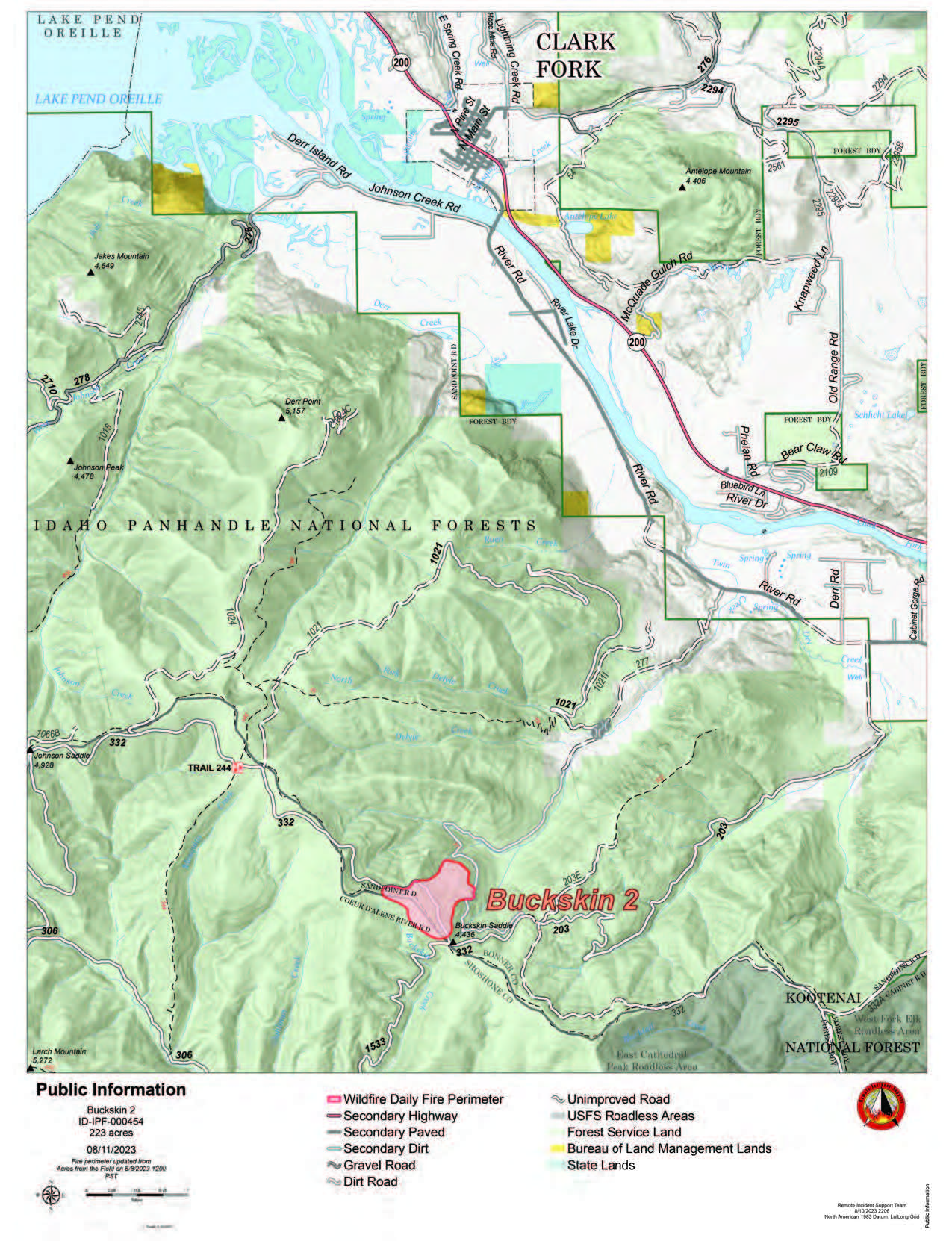
Buckskin 2 Fire
August 11, 2023
Idaho Panhandle National Forests, Sandpoint Ranger District
Fire Information: 208-557-8813
https://inciweb.nwcg.gov/incident-information/idipf-buckskin-2-fire
Type 3 Incident Commander, John Ramsey
Location: Located approximately 8 miles due south of Clark Fork, ID on Delyle Ridge, between Twin Creek and Dry Creek, south of Highway 200
Start Date: 8/4/2023
Cause: Under Investigation
Size: 226 acres (estimated)
Containment: 25%
Total Personnel: 84
Engines:7
Hand Crews: 2
Modules: 3
Heavy Equipment: Dozer
The primary objectives for fire officials managing the Buckskin 2 Fire are firefighter and public safety while working to keep it as small as possible. Yesterday, the fire was active with some single and group tree torching. The fire is estimated at 226 acres, but due to the increase in fires around the nation, an infrared flight to accurately map the fire has not yet occurred. Hand crews are constructing direct lines along the east and west flanks of the fire, while engine crews are continuing structure protection work in the Twin Creek and Rearden Creek drainages, with dozers constructing indirect lines on the north and south side of the fire. The fire remains roughly 1.8 miles from the nearest residence in Twin Creek and Rearden Rd.
EVACUATION STATUS
The Bonner County Sheriff’s Office issued a READY notification for the Twin Creek Rd and Rearden Rd residents in Clark Fork. “Ready, Set, Go” is a program for residents that can help them prepare for an evacuation in case of any emergency and keep them informed about evacuation needs/concerns. To receive local status updates, sign up for Bonner County Sheriff’s Office emergency messaging through NIXLE at www.nixle.com; to learn more about the “Ready, Set, Go” program as well as recommendations on how to be best prepared for wildfire, check out this page from the Idaho Department of Lands.
CLOSURES AND SPECIAL MESSAGES
A Forest Closure Order is officially in effect for roads associated with the Buckskin Fire; the intersection of Forest Service Roads 203 and 332, the intersection of FSR 1021 and 332, and 1533 and 306 in Clark Fork. UTV trail 77 is closed as it goes right into the drainage where the fire is burning. The public is prohibited from the general area for firefighter safety and asked practice caution while driving near firefighters and apparatuses.
It is expected that the FSR 203 closure will be extended to the edge of private land.
Stage II Fire Restrictions went into effect on Wednesday, 8/9. To view the Idaho Fire Restrictions Plan and a statewide map with current information regarding fire restrictions, please visit https://www.idl.idaho.gov/fire-management/fire-restrictions-finder.
A Temporary Flight Restriction is in place for the safety of our aerial resources and firefighters on the ground. This includes drones; please do not fly unmanned aircraft (drones) in the fire vicinity. If you fly, we can't.
WEATHER
Today’s forecast calls mostly sunny, with a steady temperature around 79 and a southwest wind of 8 to 16 mph.
Little Mesa Fire Forest Service Road and Trail Closure
Related Incident: Little Mesa Fire
Publication Type: Closures
The Grand Mesa, Uncompahgre and Gunnison National Forests have issued a forest closure order for the area around the #LittleMesaFire. Public access to the closure area is limited, and includes National Forest System Road (NFSR) #502 – Dry Mesa road, NFSR #501.1A – South Bench road, National Forest System Trail (NFST) #102 – Picket Corral trail, NFST #102.1A – Picket Corral Spur trail and NFST #104 – Cabin Bench Area trail.
The public is asked to adhere to the closure for public health and safety of our fire personnel.
Learn more here: https://bit.ly/3YwXNz0.
Little Mesa Fire Update August 11 2023
Related Incident: Little Mesa Fire
Publication Type: News
Little Mesa Fire Update
Friday, August 11, 2023
Location: Approx. 15 miles west, southwest of Delta, CO, Dominguez Escalante National Conservation Area
Discovered: July 31, 2023, 11:00 AM
Cause: Lightning
Estimated Size: 433 acres
Vegetation Type: Pinyon, Juniper, sagebrush, grass
Containment: 0%
Strategy: Full Suppression
Total Personnel: 76
NOTICE TO THE PUBLIC: Air operations are being conducted on the Little Mesa Fire. For your safety, please stay out of the Potholes Recreation Area. The helicopters are using this water source for fire suppression.
Current Situation: The fire area received very light rain last night but not enough to have a significant effect on fire behavior. Yesterday’s Multi-Mission Aircraft flight measured the fire at 433 acres. Firefighters spent yesterday cleaning up islands of unburnt fuel in Division A to secure Tatum Ridge Rd, which caused an increase in smoke put up from the fire area. Several spots were thrown into Little Canyon but crews were able to catch them before they spread. In Division Z, final scouting and prep work of Black Ridge to Black Point was completed and a plan was finalized for aerial ignitions to reinforce the line today.
Today’s plan is for firefighters in Div A to patrol Tatum Ridge Rd and continue to protect Escalante Canyon. In Div Z, crews will hold the fire line while aerial ignitions are performed to strengthen the fire line to the south and southeast, as conditions allow. This could cause a significant increase in smoke this afternoon into the evening.
Weather: Similar to yesterday’s forecast, the fire area has a chance of showers this evening into tonight. Winds out of the Southwest will push smoke towards Delta.
Evacuations and Closures: No evacuations have been issued. Temporary road closures in Delta County on Dry Mesa Rd at the intersection with Escalante Rim Rd and on USFS Dry Mesa Rd at Sawmill Mesa Rd junction. The Grand Mesa, Uncompahgre and Gunnison National Forests have issued a forest closure order for the area around the Little Mesa Fire. Public access to the closure area is limited, and includes National Forest System Road (NFSR) #502 – Dry Mesa road, NFSR #501.1A – South Bench road, National Forest System Trail (NFST) #102 – Picket Corral trail, NFST #102.1A – Picket Corral Spur trail and NFST #104 – Cabin Bench Area trail.
Smoke: Smoke is visible from surrounding areas and Highways 50, 550, 92, 65, 141 and C37 Road. Go to fire.airnow.gov or colorado.gov/airquality/ to get updates on smoke conditions.
Aviation Safety: Incident aircraft may be flying over the Little Mesa Fire air space. Fire aviation resources are flying at different altitudes and speeds. Unmanned aircraft systems (UAS) or drones must never fly near wildfires. The only UAS or drones able to fly are agency owned and operated, which have been assigned to work on the wildfire and have communication with air operations. Remember if you fly, we can’t!
For updated information follow on these outlets:
Inciweb: https://inciweb.wildfire.gov/incid.../coupd-little-mesa-fire
Facebook: @LittleMesaFire Twitter: @SWD_Fire