
Settings - change map background and toggle additional layers
Filter - control incident types displayed on map.
Zoom to your location
Reset map zoom and position
Could not determine your location.
Show Legend
 Wildfire
 Prescribed Fire
 Burned Area
Response
Burned Area
Response Other
Other
Hawkeye Fire
Unit Information
Incident Contacts
Settings - change map background and toggle additional layers
Filter - control incident types displayed on map.
Zoom to your location
Reset map zoom and position
Could not determine your location.
Show Legend
- Wildfire
- Prescribed Fire
- Burned Area
Response
- Other
Burnett 109 Fire
Unit Information
Incident Contacts
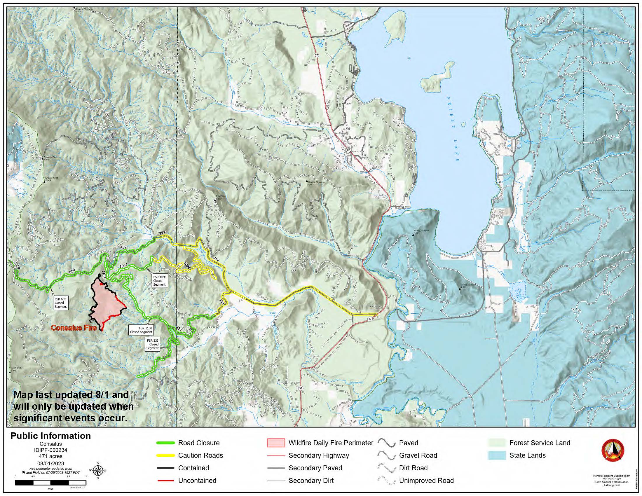
August 12 2023 Consalus Update
Related Incident:
Publication Type: News
Consalus Fire August 12, 2023
Priest Lake Ranger District, Idaho Panhandle National Forests
Incident Commander: Jake Hirst
Fire Information 208-996-0980 | 2023.consalus@firenet.gov
Location: 10 miles west of Coolin, ID, in Pend Oreille County, WA
Start Date: 6/30/2023 Cause: Lightning Size: 475 acres Containment: 80%
Unless significant activity occurs, updates are being produced as needed
The Consalus Fire is being managed by fire officials out of the Priest Lake Ranger District. The fire remains at 80% contained, with firefighters working to mop up and secure the fireline around the other 20% of the perimeter. Crews are patrolling and monitoring the edge of the fire throughout the day while continuing to backhaul any unneeded equipment from the field. Within the perimeter of the fire, smoke has been seen from pockets of unburned fuels, and that can be expected to continue, especially on hot and dry days, until the area receives considerable precipitation.
In addition, work has begun to complete all that is outlined in the suppression repair plan. There is a considerable amount of work to be done to clear and improve roads that were impacted by fire activity. The Forest Closure Order will remain in effect until further notice for public and firefighter safety as the suppression repair work is expected to continue well into the fall.
CLOSURES AND SPECIAL MESSAGES
The Idaho Panhandle National Forests issued an emergency closure (Closure Order # 01-04-08-23-003) effective July 18, 2023. This replaced Closure Order #01-04-08-23-002. The emergency closure has been issued for public safety and prohibits all forms of travel on: Forest Service Road (FSR) #1108 from the junction with FSR #333 to the junction with FSR #659; FSR #1094 will remain open for the first 4.5 miles from the junction with FSR #312, but the remainder of FSR #1094 will be closed to the junction with FSR #1108. Additional road closures now include FSR #659 from the junction with FSR #312 to the junction with FSR #659B; FSR #333 from the junction with FSR #2730 to its terminus.
For firefighter and public safety, please avoid the following roads if possible as crews and heavy equipment continue to utilize these roads to access the fire area: The remaining portion of FSR #1094 is not part of the closure order; FSR #312 from the junction with FSR #333 to the junction with FSR #659; and FSR #333 from Highway 57 to the junction with FSR #1108. Please refer to the incident PIO map for a visual explanation.
Little Mesa Fire Update August 12 2023
Related Incident: Little Mesa Fire
Publication Type: News
Little Mesa Fire Update
Saturday, August 12, 2023
Location: Approx. 15 miles west, southwest of Delta, CO, Dominguez Escalante National Conservation Area
Discovered: July 31, 2023, 11:00 AM
Cause: Lightning
Estimated Size: 642 acres
Vegetation Type: Pinyon, Juniper, sagebrush, grass
Containment: 0%
Total Personnel: 75
NOTICE TO THE PUBLIC: Air operations are being conducted on the Little Mesa Fire. For your safety, please stay out of the Potholes Recreation Area. The helicopters are using this water source for fire suppression.
Current Situation: Yesterday’s Multi-Mission Aircraft flight measured the fire at 642 acres. Resources continued cleaning up unburnt piles of dead and down along Tatum Ridge Rd to secure Escalante Canyon. They also “mopped up” hot spots along the road. Mopping up is the process of manually removing and extinguishing all sources of heat (such as smoldering logs or subsurface burning tree roots) within a certain proximity to the fire line, usually 100 to 300 feet. A fire’s edge cannot be considered contained until mop up is complete.
Conditions for aerial ignitions yesterday were not conducive until late in the day. Due to a short flight window, helicopter ignitions were postponed. Some ignitions were performed by UAS between Dry Mesa and Little Canyon to clean up unburnt pockets of fuel. Another attempt will be made at aerial ignitions today to achieve the goal of strengthening the fire line to the south and southwest edges of the fire perimeter. A significant increase in smoke will be observed while ignition operations are performed.
Weather: There continues to be a chance of rain over the fire area throughout the day and mostly cloudy conditions are expected. Light winds 8-13 mph are forecast out of the west.
Evacuations and Closures: No evacuations have been issued. Temporary road closures in Delta County on Dry Mesa Rd at the intersection with Escalante Rim Rd and on USFS Dry Mesa Rd at Sawmill Mesa Rd junction. The Grand Mesa, Uncompahgre and Gunnison National Forests have issued a forest closure order for the area around the Little Mesa Fire. Public access to the closure area is limited, and includes National Forest System Road (NFSR) #502 – Dry Mesa road, NFSR #501.1A – South Bench road, National Forest System Trail (NFST) #102 – Picket Corral trail, NFST #102.1A – Picket Corral Spur trail and NFST #104 – Cabin Bench Area trail.
Smoke: Smoke is visible from surrounding areas and Highways 50, 550, 92, 65, 141 and C37 Road. Go to fire.airnow.gov or colorado.gov/airquality/ to get updates on smoke conditions.
Aviation Safety: Incident aircraft may be flying over the Little Mesa Fire air space. Fire aviation resources are flying at different altitudes and speeds. Unmanned aircraft systems (UAS) or drones must never fly near wildfires. The only UAS or drones able to fly are agency owned and operated, which have been assigned to work on the wildfire and have communication with air operations. Remember if you fly, we can’t!
For updated information follow on these outlets:
Inciweb: https://inciweb.wildfire.gov/incident-information/coupd-little-mesa-fire
Facebook: @LittleMesaFire Twitter: @SWD_Fire
Cedar Top Fire Final Update August 12 2023
Related Incident: Cedar Top Fire
Publication Type: News
Craft Fire
News - 08/10/2023
Cedar Top Fire Final Update
August 12, 2023
4:00 PM
Size: 2,308 acres
Containment: 100%
Start Date: August 9, 2023
Cause: Unknown
On August 9, around 2:00 p.m. Texas A&M Forest Service received a request for assistance on a fire burning approximately 15 miles northwest of Seymour, Texas in Knox County.
Texas A&M Forest Service crews completed all containment lines and mop up operations, any fire activity was mitigated and the Cedar Top Fire reached 100% containment by the end of the operational shift today.
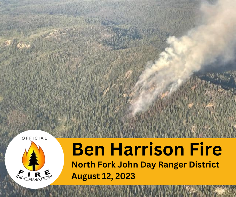
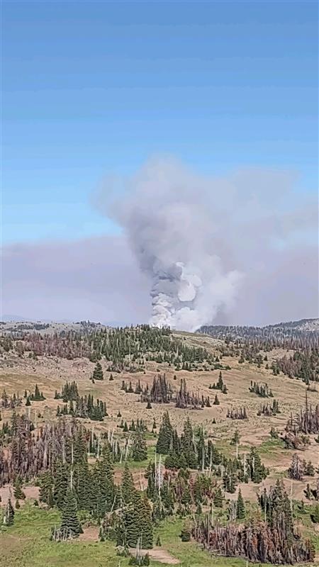
Ben Harrison Fire August 12 2023 Update
Related Incident: Ben Harrison Fire
Publication Type: News
Firefighters continue suppression efforts on the Ben Harrison Fire, which is burning approximately 20 miles west of Sumpter, Oregon on the North Fork John Day Ranger District.
The Ben Harrison Fire, which was reported on Friday, Aug. 11, is burning generally toward the north and northeast in steep and rocky terrain with heavy timber within the North Fork John Day Wilderness. The fire experienced active fire behavior throughout the afternoon yesterday as hot and windy conditions contributed to increased fire behavior and growth. Firefighters, aided by aerial resources, focused suppression efforts on establishing containment lines to slow the spread of the fire. The fire is roughly estimated at 50-75 acres. Fire managers have ordered a reconnaissance flight today to look at the fire’s progression and identify a more accurate acreage.
Today firefighters will continue to build containment lines, where terrain and fuels allow for crews to safely engage, while utilizing aircraft to slow fire spread. Due to the rough terrain, snags (dead standing trees), and remote location crews are looking for natural features to stop the spread of the fire while also allowing for fire fighter safety. Approximately 80 personnel are being assigned to the fire today.
In preparation for the upcoming predicted weather and increased fire activity, fire managers are ordering additional resources, including a Type 2 Incident Management Team (IMT). The Type 2 IMT is expected to arrive on Sunday, Aug. 13, 2023.
Hot and dry conditions are expected to persist throughout the weekend. Fire officials want to remind everyone that the current fire danger rating remains at HIGH and public use restrictions involving chainsaw use, smoking and off-road travel are in effect.
For more information regarding Restrictions, please contact:
Umatilla National Forest:
Information Hotline: Toll-Free (877) 958-9663
www.facebook.com/UmatillaNF Twitter: @UmatillaNF
The latest fire information will be posted on the Blue Mountains Fire Information Blog. To receive updates on fires in the Blue Mountains, follow our blog at http://bluemountainfireinfo.blogspot.com/.
Additional information about the Umatilla National Forest is available at: http://www.fs.usda.gov/umatilla.
Buckskin 2 Fire Update August 12 2023
Related Incident:
Publication Type: News
Buckskin 2 Fire
Idaho Panhandle National Forests, Sandpoint Ranger District Fire Information: 208-557-8813
https://inciweb.nwcg.gov/incident-information/idipf-buckskin-2-fire Type 3 Incident Commander, John Ramsey
August 12, 2023
Location: Located approximately 8 miles due south of Clark Fork, ID on the upper end of Twin Creek and Buckskin Saddle, south of Highway 200
Start Date: 8/4/2023
Cause: Under Investigation
Size: 226 acres (estimated)
Containment: 25%
Total Personnel: 84
Engines: 7
Hand Crews: 2
Modules: 3
Heavy Equipment: 2 Dozers
The Buckskin 2 Fire was mapped by firefighters on the ground and is roughly 226 acres with 25% containment. The primary objectives for fire officials continue to be firefighter and public safety while keeping the fire as small as possible. Crews and dozers are working to construct direct lines along the northwest flanks of the fire. Engine crews are completing a more detailed structure assessment in the Twin Creek and Rearden Creek drainages; this intel is being collected to assist firefighters working on Buckskin 2 as well as any future fires that may impact the area. The fire remains roughly 1.8 miles from the nearest residence in Twin Creek and Rearden Rd.
EVACUATION STATUS
The Bonner County Sheriff’s Office issued a READY notification for the Twin Creek Rd and Rearden Rd residents in Clark Fork. “Ready, Set, Go” is a program for residents that can help them prepare for an evacuation in case of any emergency and keep them informed about evacuation needs/concerns. To receive local status updates, sign up for Bonner County Sheriff’s Office emergency messaging through NIXLE at www.nixle.com; to learn more about the “Ready, Set, Go” program as well as recommendations on how to be best prepared for wildfire, check out this page from the Idaho Department of Lands.
CLOSURES AND SPECIAL MESSAGES
A Forest Closure Order is officially in effect for roads associated with the Buckskin Fire; the intersection of Forest Service Roads 203 and 332, the intersection of FSR 1021 and 332, and 1533 and 306 in Clark Fork. UTV trail 77 is closed as it goes right into the drainage where the fire is burning. The public is prohibited from the general area for firefighter safety and asked to practice caution while driving near firefighters and apparatuses. It is expected that the FSR 203 closure will be extended to the edge of private land.
Stage II Fire Restrictions went into effect on Wednesday, 8/9. To view the Idaho Fire Restrictions Plan and a statewide map with current information regarding fire restrictions, please visit https://www.idl.idaho.gov/fire-management/fire-restrictions-finder.
A Temporary Flight Restriction is in place for the safety of our aerial resources and firefighters on the ground. This includes drones; please do not fly drones in the fire vicinity. If you fly, we can't.
WEATHER
Today, sunny with temperatures around 80-85. Southwest winds 3-12 with gusts to 25 mph. Continued hot and dry weather with temperatures ranging from mid 80's to high 90's is forecasted for the next 7 days.
Settings - change map background and toggle additional layers
Filter - control incident types displayed on map.
Zoom to your location
Reset map zoom and position
Could not determine your location.
Show Legend
- Wildfire
- Prescribed Fire
- Burned Area
Response
- Other
Ben Harrison Fire
Unit Information
Incident Contacts
Pogo Mine Road 191 Mount Hayes 299 Fires Update 8122023
Related Incident: Pogo Mine Road FireMount Hayes Fire
Publication Type: News
WILDFIRE UPDATE - Pogo Mine Road Fire (#191) & Mount Hayes Fire (#299)
Saturday - August 12, 2023
More Fire Crews arrive, drones fly to help map fires and locate hot spots.
Additional resources continue arriving to help with structure protection and completion of incident objectives that will safeguard values at risk in the event fire activity increases. A Temporary Flight Restriction is in place for both fires, so check NOTAMs if flying in the area.
Pogo Mine Road Fire (#191) – 47,136 acres | 46 personnel | 12 miles NW of Delta
Tanana Chiefs Conference fire crew returned to the fire and continued working to secure private property and infrastructure near the Pogo Mine Gate. The north and east portions of the fire are unstaffed and being monitored by aircraft. Firefighters are patrolling Shaw Creek by boat, ensuring structure protection equipment is functional. An Unmanned Aircraft Systems (UAS) or drone module is searching for hotspots and helping to map the fire more accurately. A helicopter provided bucket work, dropping water on hotspots in the southwestern area near the pipeline and Quartz Lake.
Mount Hayes Fire (#299) – 7,085 acres | 66 personnel | 7 miles SE of Deltana
This fire is being managed for multiple objectives including using fire for habitat restoration in the Bison Fields area. Three cabins, on Donna, Little Donna, and Lisa lakes have been identified near the fire east of the Gerstle River. The Tongass Fire Suppression module will hike into these structures to assess protection needs. Control lines from Bison Fields to the Gerstle River are plumbed with a hoselay, completed, and ready for a firing operation or burnout when fuel conditions are receptive.
Weather: A thermal low pressure will remain in place and then move north of the fire this evening, causing strong southeast winds today along with isolated afternoon and evening thunderstorms. Expect mostly sunny skies then becoming mostly cloudy with max temperatures around 73 degrees and low relative humidity in the 40’s. East winds at 3-5 mph are forcasted for the morning increasing to 15 mph in the afternoon.
Fire Information: Phone number: 541-977-2756 / Fire Info website: AkFireInfo.com Facebook: AK.Forestry / Twitter: @AK_Forestry / YouTube: AlaskaDNRDOF
Anderson Complex Daily Fire Update for August 12 2023
Related Incident: Anderson Complex
Publication Type: News
Anderson Complex crews eliminate threat to more than a third of structures
More than a third of the structures that were initially threatened by fires in the Anderson Complex are no longer at risk thanks to hard work by firefighters and more favorable weather. Crews remain fully committed to protecting the remaining structures and allotments that are still threatened by fire.
FIRE UPDATE: A Blackhawk helicopter assigned to the complex dropped water yesterday on the southeast edge of the Teklanika River Fire (#257) after an increase in fire activity was observed. Water was also dropped on the Shores Landing Fire (#325) after its western edge became more active. A Franco Type 2 hand crew is still in the area today. They are working to secure fire line where possible. They are also keeping pumps, hoses, and sprinklers running near structures and allotments still threatened by the fires.
Crews in the Anderson-Nenana Group are staying in the City of Anderson or patrolling along the Parks Highway north to Nenana. In Anderson they are frequently checking the pumps, hoses, and sprinklers to ensure they will work if needed. Firefighters working along the Parks Highway continue to assess the protection needs of structures and identify potential values at risk. The Anderson-Nenana Group and Clear Group still have initial attack responsibility for any new fires that start within the Anderson Complex.
The Shasta Lake Hotshots have been working to restore access to the Rose Hip Creek area by clearing trees that have fallen across roads. The crew routinely checks the pumps, hoses and sprinklers around structures and allotments to ensure they are functioning properly. They will continue to search for and extinguish hotspots today in addition to their structure protection mission.
Crews from Kobe, Anderson, Northstar, the Alaska Division of Forestry & Fire, K River 1 and Franco Reforestation are maintaining sprinkler systems set up around structures in the North Forties and Kobe Ag subdivisions. They are also working with heavy equipment operators to clear brush and vegetation from around structures or along roads to reduce fuel loads and improve access.
The Rock Creek Fire (#287) has not shown any growth in nearly a week. No crews have been assigned to the fire, but plans are being drafted to protect the structures and allotments in the area.
The Anderson Complex includes the Teklanika River Fire (#257), Birch Creek Fire (#285), Shores Landing Fire (#325), Rock Creek Fire (#287), Bear Creek Fire (#287), Kobe Road Fire (#297), Nenana River Fire (#288), and Nenana River 2 Fire (#289).
WEATHER: The forecast calls for warm, dry, windy conditions beginning today and continuing through Sunday night. East winds are expected today and should be strongest in the Nenana area, with gusts up to 25 mph. Wind speeds should be lower to the south along on the Parks Highway corridor, but 15 mph gusts will still be possible. Firefighters know flames can spread rapidly through black spruce with winds as low as 5 mph. They are ready to act if fire activity begins to pick up.
EVACUATION STATUS: The City of Anderson, the North Forties subdivision, and Kobe Ag subdivision are in evacuation status READY. Individuals in this area should remain ready for possible evacuation.
The Teklanika River, all residents along the Teklanika River, all residents in Clear Sky homestead (not the Clear Sky Lodge), and residents adjacent to Rose Hip Creek remain in evacuation status GO. Individuals in this area should evacuate now. Do not delay. The Tri-Valley School is available for evacuation parking and will be available as an evacuation center, if needed.
Visit the Denali Borough website for additional information.
CLOSURE: The City of Anderson has closed the shooting range until further notice for firefighter and public safety. Firefighters are working in the area for the next several days. The campground and playground are open.