
Buckskin 2 Fire Update August 13 2023
Related Incident:
Publication Type: News
Buckskin 2 Fire
Idaho Panhandle National Forests, Sandpoint Ranger District Fire Information: 208-557-8813
Type 3 Incident Commander, Brian Hicks
August 13, 2023
Location: Located approximately 8 miles due south of Clark Fork, ID on the upper end of Twin Creek and Buckskin Saddle, south of Highway 200
Start Date: 8/4/2023
Cause: Under Investigation
Size: 226 acres (estimated)
Containment: 15%
Total Personnel: 106
Engines: 7
Hand Crews: 3
Modules: 3
Heavy Equipment: 3 Dozers
Yesterday’s dry and breezy conditions increased fire activity in pockets of unburned fuels within the perimeter of the fire. Sparks from these pockets spotted over the line on the northwest edge where firefighters took quick action with the assistance of 2 helicopters and 4 Firebosses (small maneuverable water scooping airtankers). The spot is estimated at 1-2 acres and has line around it completely. Due to the activity along the perimeter, fire officials reduced containment to 15%. An infrared flight has been requested for tonight; if they are able to complete the flight, it will provide more accurate mapping of the fire.
Transition to a new Type 3 Incident Commander and Operations Section Chief occurred this morning. Additional resources arrived today to help improve and hold the existing fireline in the challenging and dangerous terrain. Relative humidity is forecasted to remain low with the continued hot and dry weather, so fire officials expect to see more activity from within the interior unburned fuels. A fleet of aircraft is assigned to help fires in the region and firefighters will utilize them as needed, and when availability allows. Engine crews are completing a more detailed structure assessment plan in the Twin Creek and Rearden Creek drainages. The fire remains roughly 1.8 miles from the nearest residence in Twin Creek and Rearden Rd.
EVACUATION STATUS
The Bonner County Sheriff’s Office issued a READY notification for the Twin Creek Rd and Rearden Rd residents in Clark Fork. To receive local status updates, sign up for Bonner County Sheriff’s Office emergency messaging through NIXLE at www.nixle.com.
CLOSURES AND SPECIAL MESSAGES
Forest Closure Order is in effect for roads associated with the Buckskin Fire; the intersection of Forest Service Roads 203 and 332, the intersection of FSR 1021 and 332, and 1533 and 306 in Clark Fork. UTV trail 77 is closed as it goes right into the drainage where the fire is burning. The public is prohibited from the general area for firefighter safety and asked to practice caution while driving near firefighters and apparatuses. It is expected that the FSR 203 closure will be extended to the edge of private land.
Stage II Fire Restrictions are in effect. To view the Idaho Fire Restrictions Plan and a statewide map with current information regarding fire restrictions, please visit https://www.idl.idaho.gov/fire-management/fire-restrictions-finder.
A Temporary Flight Restriction is in place for the safety of our aerial resources and firefighters on the ground. This includes drones; please do not fly drones in the fire vicinity. If you fly, we can't.
WEATHER
Today, sunny with temperatures around 85. Winds are predicted to be out the north 3-9 mph. Continued hot and dry weather with temperatures ranging from mid 80's to high 90's is forecasted for the next week.
Lookout Fire Closure
Related Incident: Lookout Fire
Publication Type: Closures
UNITED STATES DEPARTMENT OF AGRICULTURE
FOREST SERVICE
WILLAMETTE NATIONAL FOREST
SPRINGFIELD, OREGON
ORDER # 06-18-10-23-19
FOREST ORDER
LOOKOUT FIRE EMERGENCY AREA CLOSURE
Pursuant to 16 U.S.C. § 551 and 36 CFR § 261.50 (a) and (b), and to provide for public safety,
the following acts are prohibited on the National Forest System (“NFS”) areas, roads, and trails
described below within the administrative boundaries of the Willamette National Forest. This
Order is effective on August 10th, 2023, through October 24, 2023, unless otherwise rescinded
sooner.
PROHIBITIONS:
1. Being on the road. 36 CFR § 261.54(e)
2. Being on a trail 36 CFR § 261.55(a)
3. Entering into or being upon National Forest System Lands closed for the protection of public
health and safety. 36 CFR § 261.53(e)
CLOSURE AREA:
The closure area is located within the State of Oregon, Lane County, and within the
Administrative Boundaries of the Willamette National Forest. The closure applies to the NFS
areas, roads, and trails and trailheads described below. The closure area is depicted on the
attached map, which is incorporated into this order as “Exhibit A”. All roads, trails, campgrounds,
and rec sites in this closure area are closed. Roads closed by this order are depicted in “Exhibit
B” and recreation sites, trails and campgrounds closed by this order are depicted in “Exhibit C”.
Area Closure Description
In Township 16S, Range 4E, Section 13, the closure boundary starts at the junction of Forest
Road (FR) 15 and FR 1506, the southwestern boundary of the HJ Andrews Experimental Forest
(HJA). The closure boundary proceeds north along FS Road 15 approximately 12 miles to the
intersection with FR 1506 (northern intersection). FS Road 15 will remain open to travel. The
closure boundary then follows FR 1506 south until it reaches the Frissell Trailhead North
intersection. FR 1506 will be closed to travel. The closure boundary then follows the Frissell
Trail to the west intersecting with the FR 1507 along HJA’s southern boundary. The closure
boundary then follows FR 1507 West for 1 mile. The closure boundary then proceeds West for
3/4 mile to where it intersects with FR 2633 at its most eastern point in Township 16S, Range
5E, Section 2. The closure boundary then follows Forest Road 2633 west to the switchback near
the border of the HJA approximately ½ mile from the intersection with Forest Road 1501. The
closure boundary then follows the HJA boundary west to FS Road 15.
ORDER #06-18-10-23-19
EXEMPTIONS:
Pursuant to 36 CFR § 261.50(e)(1) and (4), the following persons are exempt from this Order:
(1) Persons with Forest Service Permit No. FS-7700-48 (Permit for Use of Roads, Trails,
or Areas Restricted by Regulation or Order) specifically exempting them for this
Order.
(2) Any Federal, State, or Local Officer, or member of organized rescue or fire fighting
force in the performance of an official duty.
These prohibitions are in addition to the general prohibitions in 36 CFR Part 261, Subpart A.
Violations of these prohibitions are punishable by a fine of not more than $5,000.00 for an
individual or $10,000.00 for a corporation or imprisonment for not more than six months
or both. 16 U.S.C. § 551 and 18 U.S.C. § 3551, 3571, and 3581.
Executed in Springfield, Oregon on this 11th day of August 2023.
___________________________
David Warnack
Forest Supervisor
Willamette National Forest
Gravel Pit Fire Daily Update Sunday August 13 2023
Related Incident:
Publication Type: News
Gravel Pit Fire Daily Update
Montana Department of Natural Resources and Conservation, Northwest Land Office
WESTERN MONTANA ALL HAZARDS IMT │ INCIDENT COMMANDER: KEN PARKS
https://inciweb.wildfire.gov/incident-information/mtmts-gravel-pit-fire
2023.gravelpit@firenet.gov (406) 247-0514
Sunday, August 13, 2023 at 10:00 a.m.
Location: 25 miles southeast of Libby, near Silver Butte
Start Date: 8/1/23 Cause: Human Size: 304 acres Containment: 45%
Total Personnel: 94 Engines: 11 Tenders: 2 Hand Crews: 2
CURRENT STATUS
Yesterday, to the east and west, crews continued with mop-up activities, working in a grid pattern to locate and extinguish hot spots. Additionally, to the north, crews located and extinguished flare-ups on the interior of the fire perimeter. On the lower portion of the fire, crews began backhauling hose.
PLANNED ACTIONS
Today, crews will continue with mop-up activities, locating and extinguishing sources of heat to prevent flare-ups from occurring. Flare-ups are a sudden, localized intensification of the fire behavior. The right combination of temperature, fuel dryness, and wind will result in previously smoldering materials flaring up. Ember wash from flare-ups within the fire perimeter can ignite unburned flammable materials outside of the fire perimeter, increasing fire intensity and spread. Engines will move throughout the fire area to locate flare-ups and maintain readiness to respond to any new fire starts that occur. To the southeast, crews will backhaul hose and continue with mop-up activities.
WEATHER AND FIRE BEHAVIOR
The warming and drying trend will continue with intensifying thermal belts. Afternoon temperatures will be near record highs this week with valley locations approaching 100° F. Winds will be light from the north to northeast on the ridges. Mid and lower slopes will see light erratic winds.
Fire behavior is low, with smoldering and creeping, but the potential exists for more active fire behavior with the drying weather pattern in the coming days.
EVACUATIONS AND CLOSURES
An evacuation warning will remain in place for residents near the fire area along the Highway 2 corridor. The Lincoln County Sheriff’s Office has notified these residents. All Lincoln County residents are encouraged to sign up for emergency alerts by downloading the Code Red application and entering contact information. Code Red is the primary notification system to alert residents of evacuations.
Little Mesa Fire Update August 13 2023
Related Incident: Little Mesa Fire
Publication Type: News
Little Mesa Fire Update
Sunday, August 13, 2023
Location: Approx. 15 miles west, southwest of Delta, CO, Dominguez Escalante National Conservation Area
Discovered: July 31, 2023, 11:00 AM
Cause: Lightning
Estimated Size: 776 acres
Vegetation Type: Pinyon, Juniper, sagebrush, grass
Containment: 10%
Total Personnel: 76
NOTICE TO THE PUBLIC: Air operations are being conducted on the Little Mesa Fire. For your safety, please stay out of the Potholes Recreation Area. The helicopters are using this water source for fire suppression.
Current Situation: Thanks to the hard work of fire crews, the fire is now 10% contained. Ignitions were performed yesterday by unmanned aircraft systems and by hand to clean up piles of unburnt dead and down fuel in the sage flats, and to strengthen the fire line east of Dry Mesa Rd near the Forest Service boundary. Another attempt will be made for aerial ignitions by helicopter today to secure the fire line along Black Ridge to Black Point. If unsuccessful, crews will continue with hand ignitions to meet objectives. A significant increase in smoke will be observed while ignition operations are performed.
Fire managers are utilizing a confine and contain suppression strategy on the mesa tops (Little Mesa, Dry Mesa, and Black Ridge Mesa) to achieve resource benefits while protecting identified values. Those values are firefighter and public safety, private lands, state lands, cultural sites, and threatened/endangered plants. The resource benefits include improved long-term wildlife habitat and restoration of more natural conditions to fire-dependent landscapes, which will reduce the future likelihood of large, catastrophic wildfires.
Weather: Monsoon moisture will keep relative humidities between 15-20%. Scattered showers and thunderstorms will stay mainly over higher terrain north of the fire. The potential for wetting rains will be low over the fire today. Gusty outflow winds and lightning are the primary concern with these storms.
Evacuations and Closures: No evacuations have been issued. Temporary road closures in Delta County on Dry Mesa Rd at the intersection with Escalante Rim Rd and on USFS Dry Mesa Rd at Sawmill Mesa Rd junction. The GMUG National Forests have issued a forest closure order for the area around the Little Mesa Fire. Public access to the closure area is limited, visit https://bit.ly/3YwXNz0 for more information.
Smoke: Smoke is visible from surrounding areas and Highways 50, 550, 92, 65, 141 and C37 Road. Go to fire.airnow.gov or colorado.gov/airquality/ to get updates on smoke conditions.
Aviation Safety: Incident aircraft may be flying over the Little Mesa Fire air space. Fire aviation resources are flying at different altitudes and speeds. Unmanned aircraft systems (UAS) or drones must never fly near wildfires. The only UAS or drones able to fly are agency owned and operated, which have been assigned to work on the wildfire and have communication with air operations. Remember if you fly, we can’t!
For updated information follow on these outlets:
Inciweb: https://inciweb.wildfire.gov/incident-information/coupd-little-mesa-fire
Facebook: @LittleMesaFire Twitter: @SWD_Fire
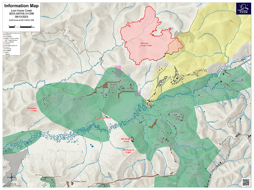
Lost Horse Creek Fire Update Sunday August 13 2023
Related Incident: Lost Horse Creek Fire
Publication Type: News
Lost Horse Creek Fire Update
August 13, 2023
Incident Commander: Peter Butteri
Start Date: July 28, 2023
Location: 22 miles N of Fairbanks, AK
Cause: Lightning
Fire Size: 9,505 acres
Containment: 12%
Total Personnel: 350
(Fairbanks, AK) – To protect values in the Haystack subdivision and along the Elliott Highway corridor, our current strategy on the Lost Horse Creek Fire (#296) is to focus direct containment efforts on the southern portion of the fire. This section of the fire is roughly eight miles or 32% of the total fire perimeter. Fire spread to the north threatens few values and will be monitored with structure protection provided as needed. Fire managers are confident that three miles of the fire’s edge (12% of the total perimeter) has been secured and contained. Structure protection is in place for the community of Haystack and structure assessments continue in the Himilaya corridor.
The eastern edge of the fire, in the 2021 Haystack Fire burn scar, still has minimal heat that crews are monitoring. The contingency line between Haystack and the Elliot Highway has been completed and is being improved. In addition, several other contingency lines are in various stages of planning and implementation.
Our Creek Fire (#271) is at approximately 90% containment and in mop-up status.
Sunday’s weather is expected to be calmer than Saturday with easterly winds transitioning to the southeast. The southerly winds are associated with a higher chance of scattered showers.
EVACUATIONS: The Haystack subdivision remains at a Level 2 (SET). Residents are advised to remain vigilant and be prepared to evacuate if necessary. For more information: Fairbanks North Star Borough, AK | Official Website (fnsb.gov); Find My Neighborhood (arcgis.com)
CLOSURES: Alaska State Parks has closed the Olnes Pond campground to support fire operations. The BLM Eastern Interior Field Office issued an evacuation and closure order for the western portion of the White Mountains National Recreation Area. See: Alaska Fire Restrictions | Bureau of Land Management (blm.gov).
AIR QUALITY ADVISORY: Any community adjacent to an active fire may experience periods of degraded air quality. For smoke forecast and air quality measures, see Fire and Smoke Map (airnow.gov).
TEMPORARY FLIGHT RESTRICTIONS (TFR) are in effect until September 9, 2023. For details, see: 3/0799 NOTAM Details (faa.gov).
Public Information: (907) 921- 2555
Media Inquiries: (907) 921- 2554
Email: 2023.LostHorseCreek@firenet.gov
You Tube: https://www.youtube.com/AlaskaDNRDOF
www.akfireinfo.com
www.facebook.com/AK.Forestry
https://inciweb.wildfire.gov
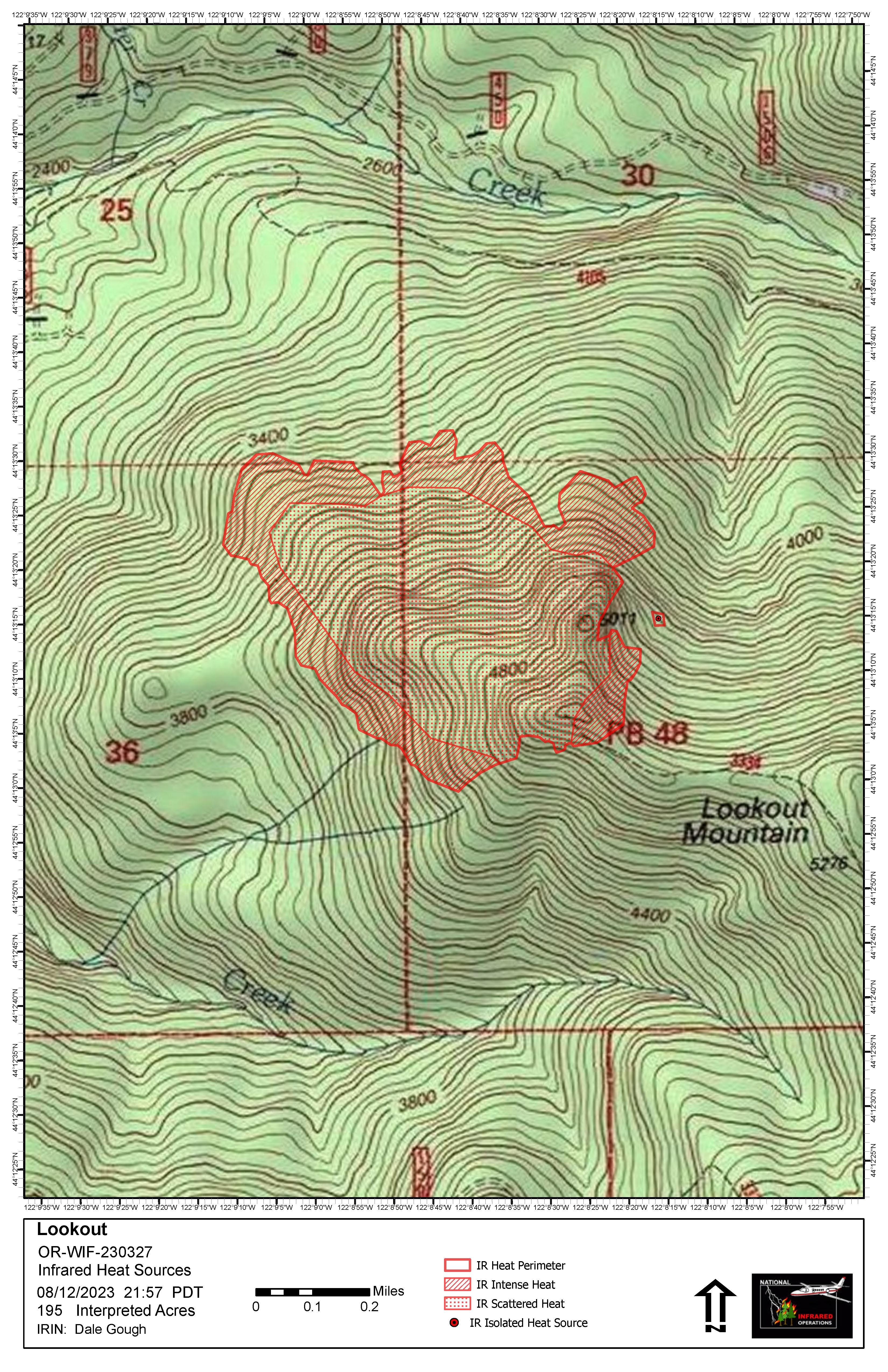
Lookout Fire Morning Update 8132023
Related Incident: Lookout Fire
Publication Type: News
Lookout Fire Quick Facts
Size: 195 acres
Start Date: August 5, 2023
Point of Origin: 3 miles North of McKenzie Bridge, OR
Cause: Lightning
Total personnel: 235
Resources: 3 Engines, 7 crews, 3 bulldozers, 3 water tenders, 3 helicopters
Current Situation: Today at 6:00 am, the Lookout Fire transitioned from Nevada Team 1, a Type 3 Incident Management Team, to Northwest Team 6, a Type 2 Incident Management Team. The Lookout Fire is burning in an area of Lookout Mountain with old growth trees and thick, dense brush. The fire was less active overnight. Fire managers have assessed the area and deemed that due to steep slopes with rolling materials, inaccessibility, and exposure to snags, it is safer for firefighters to pursue an indirect suppression strategy. Implementing an indirect suppression strategy means firefighters will be able to use strategies like using ridges, roads, and heavy machinery to have a greater chance of success in keeping the fire as small as possible as conditions change.
Today’s activities: Firefighters have scouted and identified areas around the fire that provide for safety and have a high probability of success to engage with the fire. Crews are continuing to construct fireline while also removing small trees and brush along existing roadways surrounding the fire. Aviation will continue to be used to slow the progression of the fire. Smoke may be more prevalent in the next few days with reg flag conditions predicted. These weather conditions could also contribute to more active fire behavior.
Evacuations: There is level one (be ready) evacuation in place for residents on Taylor and North Bank Roads Please monitor Lane County Sheriff’s website for current information at: https://www.lanecountyor.gov/cms/one.aspx?pageId=19729054
Weather: Temperatures are expected to be around 90 degrees. A red flag warning is in effect from Sunday at 12pm to Monday at 8pm for east winds and low humidity, and high temperatures.
Closures: The Willamette National Forest has issued a closure order for areas surrounding the Lookout Fire. The order can be found at: https://www.fs.usda.gov/detail/willamette/alerts-notices/?cid=fseprd552029
Restrictions: Fire Restrictions are in place on the Willamette National Forest https://www.fs.usda.gov/willamette
Smoke: Smoke Forecast Outlooks are available at https://outlooks.wildlandfiresmoke.net/outlook
Information Line: 541-215-6735 8am-8pm
Email: 2023.lookout@firenet.gov
Facebook: https://www.facebook.com/LookoutFire2023
Inciweb: https://inciweb.nwcg.gov/incident-information/orwif-lookout-fire
Pogo Mine Road 191 Mount Hayes 299 Fires Update 8132023
Related Incident: Pogo Mine Road FireMount Hayes Fire
Publication Type: News
WILDFIRE UPDATE - Delta Area
Pogo Mine Road Fire (#191) & Mount Hayes Fire (#299)
Sunday - August 13, 2023
Air support cools hot spots during steady winds, 2 hotshot crews join the effort.
Helicopters and fixed wing aircraft dropped water throughout the day to help keep the Pogo Mine Road Fire in check as steady southeast winds blew through the fire area. Dozers constructed an additional three miles of control lines for stronger point protection. A structure protection plan was developed for cabins on the Mount Hayes Fire with the help of Unmanned Aircraft Systems (UAS) or drones. Resource numbers continue to increase with Arroyo Grande and Sierra Hotshots arriving from California to help with management objectives.
Pogo Mine Road Fire (#191) – 47,136 acres | 127 personnel | 12 miles NW of Delta
With steady winds leading to active surface fire and group tree torching, a constant barrage of water from firefighting aircraft helped keep the fire from spreading. Helicopters dipped from 81 Mile Pond, while Fire Bosses and Super Scoopers dipped water from Quartz and Harding lakes. The water drops were focused on hot spots along the southwest portion of the fire to protect structures and keep the fire east of the pipeline during sustained winds of 15 miles per hour and 25 miles per hour gusts. Firefighters remained near structures and continued securing the fire perimeter near values at risk. Dozers built control lines to further protect structures.
Mount Hayes Fire (#299) – 7,085 acres | 75 personnel | 7 miles SE of Deltana
A structure plan has been developed to protect three cabins (Donna, Little Donna, and Lisa lakes) east of the Gerstle River. Control lines from Bison Fields to the Gerstle River are completed and plumbed with a hoselay. When fuel conditions are receptive, fire managers are planning on implementing a burnout between control lines and the main fire. This lightning-caused wildfire is being managed for multiple objectives, including using fire for habitat restoration and keeping the fire from crossing the Alaska Highway.
Weather: Steady southeast winds blew through the fire area Saturday morning and into Sunday. These winds are expected to decrease this evening. High temperatures will be in the low 70s with minimum relative humidity around 35 percent. Scattered rain showers are possible today.
A Temporary Flight Restriction is in place for the fires, pilots please check NOTAMs.
Fire Information: Phone number: 541-977-2756 / Fire Info website: AkFireInfo.com
Facebook: AK.Forestry / Twitter: @AK_Forestry / YouTube: AlaskaDNRDOF
Burnett 109 Fire Update August 13 2023
Related Incident: Burnett 109 Fire
Publication Type: News
Burnett 109 Fire
News - 08/13/2023
Burnett 109 Fire Daily Update
August 13, 2023
Size: 2,126 acres
Containment: 75%
Start Date: August 12, 2023
Cause: Unknown
On August 12, around 4:00 p.m. Texas A&M Forest Service received a request for assistance on a fire burning approximately 4 miles West of Iowa Park, Texas in Wichita County.
Yesterday Crews worked hard to contain the Burnett 109 fire as it exhibited extreme wildfire behavior, making a hard push towards HWY 287. One spot fire that had jumped HWY 287 was able to be contained quickly and crews were able to tie in all containment lines with assistance from aircraft. Today crews will continue to reinforce containment lines and mop up any hot spots that could potentially cause a problem.
Evacuations:
None.
Closures:
HWY 287 has since been opened back up.
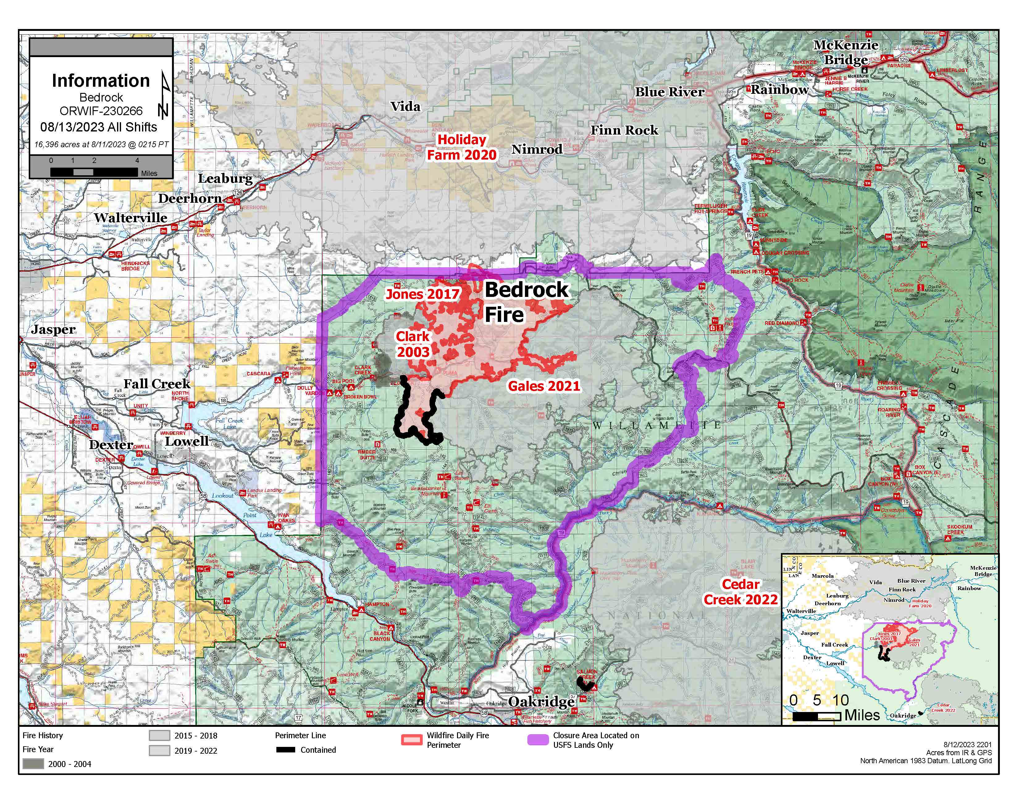
Bedrock and Salmon Fires Daily Update August 13 2023
Related Incident: Salmon FireBedrock Fire
Publication Type: News
Bedrock Fire: Yesterday afternoon multiple spot fires across primary containment lines grew together along the 1817 road in the northwestern portion of the fire. Heavy helicopters used water bucket drops to slow fire spread, and firefighters today will be focused on securing this area of new fire growth. There was active fire behavior last night and a small “slopover” occurred on the western fire edge where fire crossed over containment lines; night crews quickly secured this area to prevent further fire spread. Firefighters on the northwestern and northeastern fire perimeters are continuing to deepen and strengthen fire control lines through tactical firing operations, followed by securing and holding the burned areas. These firing operations combined with lingering burning well inside the fire’s interior may produce heavy smoke at times today. Fire crews on the southern and southeastern portions of the fire are continuing to mop up and secure around the fire.
Salmon Fire: Firefighters are continuing to mop up around the fire perimeter. Fire crews are utilizing heavy equipment to build shaded fuel breaks by removing understory and ladder fuels along roads near the fire.
Evacuations: The Lane County Sheriff's Office issued a Level 1 “Be Ready” evacuation notice Monday for areas north and east of Oakridge because of the Salmon Fire. Follow all evacuation notices and orders. A searchable evacuation map with fire perimeters for both fires is available at Lane County’s website. This map has a ruler tool so the distance from the fires to various towns can be measured.
Smoke: Areas north and east of the fire are forecasted to have good air quality today. Eugene is expected to have moderate smoke. McKenzie and Oakridge are predicted to experience Unhealthy for Sensitive Groups (USG) to unhealthy air quality conditions.
Weather: A Red Flag Warning remains in effect today through early Monday evening for gusty winds and low relative humidity, critical fire weather conditions that can contribute to extreme fire behavior. There is also a Heat Advisory from 11 AM this morning through 10 PM Thursday. Temperatures will be 94-98 degrees at lower elevation and 83-88 degrees on the ridges. Winds will begin this morning 3-6 mph, increasing to 13 mph this afternoon with gusts to 20 mph on ridgetops.
Safety and Closures: The Willamette National Forest implemented the Bedrock Fire Emergency Area Closure on July 24 to ensure the safety of the public and personnel working on the fire. An emergency closure order for the Salmon Fire area is in place as of August 8. The closure maps for the Bedrock and Salmon Fires are available on InciWeb. There are Temporary Flight Restrictions over the Bedrock and Salmon Fire areas. Residential electrical outages can be reported to Lane Electric at 541-484-1151.
Inciweb Salmon: https://inciweb.wildfire.gov/incident-information/orwif-salmon-fire
Inciweb Bedrock: https://inciweb.nwcg.gov/incident-information/orwif-bedrock-fire
Facebook: https://www.facebook.com/BedrockFire2023/
Fire Information: (541) 414-6272, 8:00 AM – 8:00 PM Email: 2023.bedrock@firenet.gov