
Fighting Wildfire Safely in Diverse Landscapes
Related Incident: Black Feather Fire
Publication Type: News
Black Feather Fire -Fighting Wildfire Safely in Diverse Landscapes
Photos show the San Pedro Park Wilderness area near the Cutoff trail from Rito de las Perchas to Vega Redonda. Taken in September 2010, the photos show a landscape where you literally cannot see the forest for the trees.
While this type of fuel loading is unfortunately common in many mixed conifer forests, it is often not safe to deploy firefighters directly into these conditions. Not only are injuries more likely in overgrown forests such as these, but if a firefighter is injured, evacuation delays due to access challenges can be life threatening.
Under normal conditions, fire managers aim to have medical extraction plans that allow for an injured person to get to a hospital within less than one hour. Whereas the extraction time in a forest like this can be delayed to several hours. While fires like this call for a suppression response, tactics and strategies other than direct attack often prove safer for firefighters.
Layers of dense, thick dead and down material, creates fuel, that when it burns, it burns hot and with high intensity creating large amounts of smoke as was seen on Sunday, August 6, 2023, when the fire was first reported. When these types of conditions occur, it is safer for fire personnel to work outside these dense fuel areas to create primary and alternate containment lines.
On the Black Feather Fire, firefighters are working to remove dense fuels along key holding features like roads, and natural areas like meadows. This provides protection for communities without compromising firefighter safety. Firefighters are using numerous, safe fire suppression approaches. For example, crews are using chippers to break dead and down material into smaller pieces. Chipping fuels reduces the intensity of fire and the amount of time it takes to burn. This reduces some of the negative effects that fire can have, to both humans and the landscape. Some of the chipped material will be hauled away outside of the fire area.
Operations Section Chief Chad Rice explains some of the challenges firefighters are face with the Black Feather Fire in the Wilderness Challenges Video.
Bowles Creek Fire August 142023
Related Incident: Bowles Creek Fire
Publication Type: News
Crews on the east side continue to construct a fuel break in the fire area. Chipping operations continue along FS Road 5070 south towards Sand Basin Creek. Snag removal operations continue in the Crystal Creek Area. The crews on the west side continue to secure the line down to Railroad Creek, fortify the fire line and install hose lays. Crews continue to evaluate values of risk and mitigate as needed.
Buckskin 2 Fire Update August 14 2023
Related Incident:
Publication Type: News
Buckskin 2 Fire
Idaho Panhandle National Forests, Sandpoint Ranger District
Fire Information: 208-557-8813
August 14, 2023
Location: Located approximately 8 miles due south of Clark Fork, ID on the upper end of Twin Creek and Buckskin Saddle, south of Highway 200
Start Date: 8/4/2023
Cause: Under Investigation
Size: 264 acres
Containment: 15%
Total Personnel: 140
Engines: 7
Hand Crews: 4
Modules: 3
Heavy Equipment: 3 Dozers
Yesterday the fire displayed moderate fire behavior with some group tree torching and backing. Aircraft assisted ground resources with water drops throughout the day and they will continue to assist today as needed and available. Crews and dozers are reinforcing the direct fire line along the spot fire in the northwest corner as well as building direct line on the western flank. Firefighters will continue to improve, hold, and mop up the existing firelines along the remaining perimeter of the fire while falling hazardous trees.
An infrared (IR) flight took place last night and the fire was roughly mapped at 264 acres. Due to possible discrepancies in the IR data fire officials will be mapping areas in question from the ground today. Additional firefighters have arrived to assist with suppression efforts as the fire is burning in challenging steep terrain with large amounts of standing dead and down trees from root rot and beetle kill.
Fire activity and smoke production from interior pockets of unburned fuels is expected to continue through the forecasted hot and dry weather. Engine crews continue to build a more detailed structure assessment plan for the residents of Twin Creek and Rearden Road. The fire remains roughly 1.8 miles from the nearest residence in Twin Creek and Rearden Rd.
EVACUATION STATUS
The Bonner County Sheriff’s Office issued a READY notification for the Twin Creek Rd and Rearden Rd residents in Clark Fork. To receive local status updates, sign up for Bonner County Sheriff’s Office emergency messaging through NIXLE at www.nixle.com.
CLOSURES AND SPECIAL MESSAGES
Forest Closure Order is in effect for roads associated with the Buckskin Fire; the intersection of Forest Service Roads 203 and 332, the intersection of FSR 1021 and 332, and 1533 and 306 in Clark Fork. UTV trail 77 is closed as well. An extension of the FSR 203 closure, extending to the edge of private land, is pending. The public is prohibited from the general area for firefighter safety and asked to practice caution while driving near firefighters and apparatuses.
Stage II Fire Restrictions are in effect. To view the Idaho Fire Restrictions Plan and a statewide map with current information regarding fire restrictions, please visit https://www.idl.idaho.gov/fire-management/fire-restrictions-finder.
A Temporary Flight Restriction is in place for the safety of our aerial resources and firefighters on the ground. This includes drones; please do not fly drones in the fire vicinity. If you fly, we can't.
WEATHER
A high-pressure system has set in with much warmer and drier conditions predicted through the week. Today, sunny with temperatures in the upper 80’s and winds around 6 mph out of the southwest.
Lookout Fire Morning Update 8142023
Related Incident: Lookout Fire
Publication Type: News
Lookout Fire Morning Update
August 14th 2023
Size: 1,202 acres
Start Date: August 5, 2023
Point of Origin: 3 miles North of McKenzie Bridge, OR
Quick Facts
Cause: Lightning
Total personnel: 350
Resources: 3 engines
7 crews
3 bulldozers
3 water tenders
4 helicopters
Current Situation: Red Flag conditions caused the fire to increase in activity yesterday and burn actively into the evening. Winds shifted out of the East and were reported to have gusts up to at least 25 mph. This caused fire embers to travel distances of up to 1 mile, causing additional ignitions West of the fire. In the early evening, the fire crossed over the top of Lookout Ridge.
We received an influx of help yesterday in the form of Oregon State Fire Marshall structure fire engines from all across the state. These engines were able to scout the area and have been integrated into operations as structure protection.
Today’s activities: Type one helicopters will continue to support operations on the fire with water drops while crews and heavy equipment continue to construct primary and secondary firelines. Crews will continue utilizing roadways and previous burn units as a secondary option. Structure protection in and around the fire area is in place. Today’s weather is predicted to be warmer than yesterday. This may cause fire behavior to be more active and smoke to be more abundant. Fire managers will continue to monitor the fire throughout the day.
Evacuations: The Lane County Sheriff has upgraded evacuation levels to include some level 3 North of Highway 126. For the most current information and a map, please see Lane County’s website at: https://www.lanecountyor.gov/cms/one.aspx?pageId=19729054
Weather: A red flag warning will continue to bring high temperatures, low humidities and east winds through Monday night.
Closures: The Willamette National Forest has issued a closure order for areas surrounding the Lookout Fire. The order can be found at: https://www.fs.usda.gov/detail/willamette/alerts-notices/?cid=fseprd552029
Restrictions: Fire Restrictions are in place on the Willamette National Forest https://www.fs.usda.gov/willamette Smoke: Smoke Forecast Outlooks are available at https://outlooks.wildlandfiresmoke.net/outlook Information Line: 541-215-6735 8am-8pm
Email: 2023.lookout@firenet.gov
Facebook: https://www.facebook.com/LookoutFire2023
Inciweb: https://inciweb.nwcg.gov/incident-information/orwif-lookout-fire
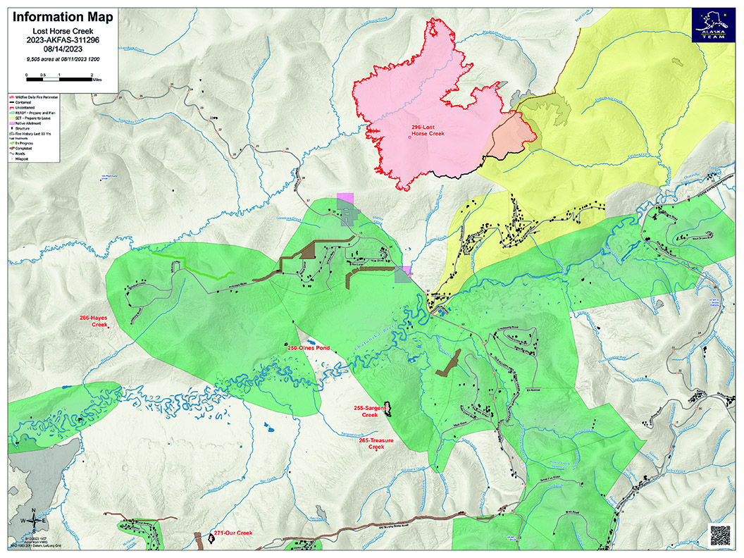
Lost Horse Creek Fire Update Monday August 14 2023
Related Incident: Lost Horse Creek Fire
Publication Type: News
Lost Horse Creek Fire Update
August 14, 2023
Incident Commander: Peter Butteri
Start Date: July 28, 2023
Location: 22 miles N of Fairbanks, AK
Cause: Lightning
Fire Size: 9,505 acres
Containment: 12%
Total Personnel: 360
(Fairbanks, AK) – The Midnight Sun and Pioneer Peak Interagency Hotshot Crews arrived on the Lost Horse Creek Fire (#296) on Saturday, joining the Lassen Hotshots. The crews were flown into the southwest corner and will spend the next several days going direct to contain the western edge where they can do so safely. Direct line along the southern edge of the fire has been completed and crews are increasing the depth up to 50 feet in some areas. Although the southern border has been contained, due to more accurate mapping, that line still represents approximately 12% of the fire perimeter. Firefighters continue to monitor the minimal fire behavior in the 2021 Haystack Fire burn scar.
Several contingency (or indirect) lines are in progress. A line from the Haystack area to the Elliot Highway is in place and work is ongoing to strengthen it. A second line north of the Elliot Highway and west of the fire is in progress. Plans for a shaded fuel break from the Haystack area running east towards the Chatanika River are expected to be implemented early in the week. These three indirect lines effectively box in the fire area on three sides and may serve as fire breaks in the future.
Our Creek Fire (#271) is 100% contained.
Early this week, we expect to see the possibility of light rain and scattered thunderstorms in the fire area. Although the deep duff layers remain dry, fire activity remains low and light winds are not expected to significantly increase fire activity.
EVACUATIONS: The Haystack subdivision remains at a Level 2 (SET). Residents are advised to remain vigilant and be prepared to evacuate if necessary. For more information: Fairbanks North Star Borough, AK | Official Website (fnsb.gov); Find My Neighborhood (arcgis.com)
CLOSURES: Alaska State Parks has closed the Olnes Pond campground to support fire operations. The BLM Eastern Interior Field Office issued an evacuation and closure order for the western portion of the White Mountains National Recreation Area. See: Alaska Fire Restrictions | Bureau of Land Management (blm.gov).
AIR QUALITY ADVISORY: Any community adjacent to an active fire may experience periods of degraded air quality. For smoke forecast and air quality measures, see Fire and Smoke Map (airnow.gov).
TEMPORARY FLIGHT RESTRICTIONS (TFR) are in effect until September 9, 2023. For details, see: 3/0799 NOTAM Details (faa.gov).
Public Information: (907) 921- 2555
Media Inquiries: (907) 921- 2554
Email: 2023.LostHorseCreek@firenet.gov
You Tube: https://www.youtube.com/AlaskaDNRDOF
www.akfireinfo.com
www.facebook.com/AK.Forestry
https://inciweb.wildfire.gov
Bedrock and Salmon Fires Daily Update August 14 2023
Related Incident: Salmon Fire
Publication Type: Announcement
Bedrock and Salmon Fires
August 14, 2023
Daily Fire Update
Bedrock Fire Quick Facts
Size: 22,679 acres Origin: Willamette National Forest Resources: 40 engines;
Containment: 20% Cause: Under Investigation 25 crews; *9 helicopters;
Total personnel: 997 Start Date: July 22, 2023 11 dozers, 30 water tenders
Salmon Fire Quick Facts
Size: 135 acres Origin: Willamette National Forest Resources: 3 engines;
Containment: 80% Cause: Under Investigation 1 crew; 1 water tender;
Total personnel: 52 Start Date: August 6, 2023 *aircraft shared
Community Meeting: There will be a virtual community meeting tonight at 7:30 PM on the Bedrock Fire Facebook page at https://www.facebook.com/BedrockFire2023/. Questions about the Salmon and Bedrock Fires can be submitted via Facebook prior to the meeting on the event page.
Bedrock Fire: Yesterday’s Red Flag conditions led to numerous spot fires on the western fire perimeter, with the easterly winds carrying burning embers up to ¾ mile from the main fire in some instances. These new spot fires are currently west of the alternate control line at the 1817 Road and south of the 18 Road. Today fire crews, engines, dozers, and heavy helicopters will be engaging the fire on the western flank in very challenging weather conditions. The Oregon State Fire Marshall has structural fire protection engines that will be protecting homes in the Fall Creek area. Firefighters are holding and securing containment lines around the northern and eastern fire perimeters and are continuing to mop up and secure firelines on the southern and southeastern fire perimeters.
Salmon Fire: As activity declines on the Salmon Fire, fire crews and equipment are being shifted to assist with the Bedrock Fire. Firefighters are continuing to mop up around the fire perimeter.
Evacuations: The Lane County Sheriff's Office issued new Level 1 and 3 “Go now!” evacuation notices for areas west of the fire near Fall Creek Lake. The level 1 evacuation around the Salmon Fire remains in place. Please see the searchable evacuation map with fire perimeters at the Lane County website.
Smoke: Areas north and east of the fire should have good air quality today. McKenzie is predicted to have Unhealthy for Sensitive Groups (USG) overall, with some unhealthy periods. Oakridge and west along HWY 58 may have USG late morning through early evening.
Weather: A Red Flag Warning remains in effect through 8 PM tonight for unstable conditions, wind, and low relative humidity, critical fire weather conditions that can contribute to extreme fire behavior. The Heat Advisory continues this week through 10 PM Thursday. Temperatures are trending up today, 96-102 degrees at lower elevation and 87-92 degrees on the ridges. Winds will begin this morning 3-6 mph, increasing to 10-15 mph this afternoon with gusts to 20 mph on ridgetops.
Safety and Closures: The Willamette National Forest implemented the Bedrock Fire Emergency Area Closure on July 24 to ensure the safety of the public and personnel working on the fire. An emergency closure order for the Salmon Fire area is in place as of August 8. The closure maps for the Bedrock and Salmon Fires are available on InciWeb. There are Temporary Flight Restrictions over the Bedrock and Salmon Fire areas. Residential electrical outages can be reported to Lane Electric at 541-484-1151.
Inciweb Salmon: https://inciweb.wildfire.gov/incident-information/orwif-salmon-fire
Inciweb Bedrock: https://inciweb.nwcg.gov/incident-information/orwif-bedrock-fire
Facebook: https://www.facebook.com/BedrockFire2023/
Fire Information: (541) 414-6272, 8:00 AM – 8:00 PM Email: 2023.bedrock@firenet.gov
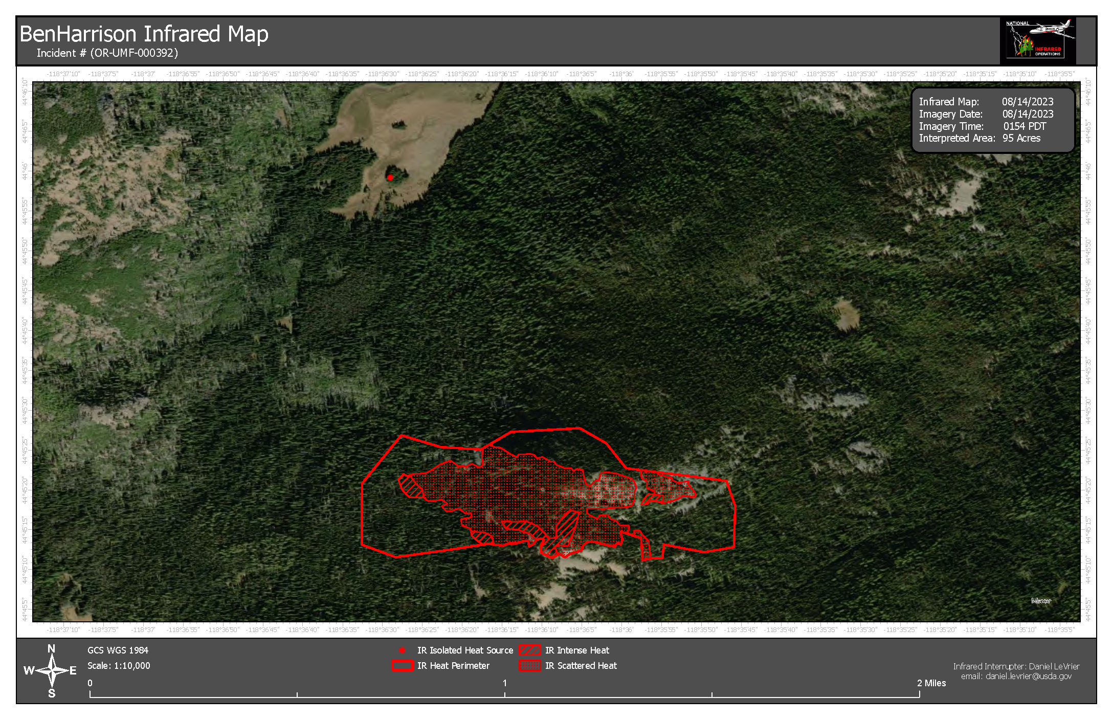
Ben Harrison Fire Update Aug 14 2023
Related Incident: Ben Harrison Fire
Publication Type: News
PENDLETON, Ore. (August 14, 2023 – 9 a.m.) — Firefighters made progress on the 95-acre Ben Harrison Fire, which is burning approximately 20 miles west of Sumpter, Oregon on the North Fork John Day Ranger District. The fire remains at 0% contained.
Fire behavior was minimal yesterday, primarily consisting of creeping and smoldering with larger fuels burning on the interior. The reduced fire behavior allowed firefighters to continue to establish control lines line along the flanks of the fire. Despite being tested by high daytime temperatures and increased afternoon winds, the current fire footprint held overnight.
Today firefighters will continue to build and strengthen control lines around the perimeter of the fire. Crews will also prepare to install hose lays, which will be used to cool areas along the perimeter of the fire once control lines are complete. Current resources assigned to the fire include 20 smoke jumpers, 3 handcrews, 4 rappellers, and local district personnel. Aircraft are available as needed.
Based on the moderated fire behavior and suppression progress completed yesterday, the North Fork John Day Ranger District will retain command of the Ben Harrison Fire to manage under a Type 3 organization using local fire management personnel.
Hot and dry conditions are expected to persist throughout the weekend. Fire officials want to remind everyone that the current fire danger rating remains at HIGH and public use restrictions involving chainsaw use, smoking and off-road travel are in effect.
For more information regarding Restrictions, please contact:
Umatilla National Forest:
Information Hotline: Toll-Free (877) 958-9663
www.facebook.com/UmatillaNF Twitter: @UmatillaNF
The latest fire information will be posted on the Blue Mountains Fire Information Blog. To receive updates on fires in the Blue Mountains, follow our blog at http://bluemountainfireinfo.blogspot.com/.
Additional information about the Umatilla National Forest is available at: http://www.fs.usda.gov/umatilla.
###
Pogo Mine Road 191 Mount Hayes 299 Fires Update 8142023
Related Incident: Pogo Mine Road FireMount Hayes Fire
Publication Type: News
WILDFIRE UPDATE - Delta Area
Pogo Mine Road Fire (#191) & Mount Hayes Fire (#299) Monday - August 14, 2023
Fire behavior increases, Crews and Aircraft keep Fire #191 in check. Community Meeting Tuesday, Aug 15 @ the Big Delta Brewing Co.
Partly sunny skies and dry weather in the Delta Junction area led to an increase in fire behavior. Plumes of smoke are visible from the Richardson Highway. Active surface fire spread with single tree torching was observed on the Delta (#221) and Ponds (#302) fires burning on Department of Defense lands south of the Tanana River and west of Delta Junction.
Pogo Mine Road Fire (#191) – 47,179 acres | 76 personnel | 12 miles NW of Delta
Helicopters dropped water on areas of heat along the southwest fire perimeter and near structures. A dozer line has been built directly along the west flank from Pogo Mine Road to the north near the pipeline corridor. Plans are being developed to utilize equipment to remove burned trees along the Pogo Mine Road, which has been blocked periodically from trees falling on the road, a safety concern. Arroyo Grande Hotshots are setting up camp along Shaw Creek to be in place for structure protection and building containment lines directly along the fire’s edge.
Mount Hayes Fire (#299) – 7,085 acres | 91 personnel | 7 miles SE of Deltana
When conditions allow, fire managers will conduct a firing operation to burnout the fuels between control lines to the north and the main fire. Fire activity has been moderated, where fire growth has been minimal in this area. Fire managers routinely monitor this fire by helicopter and airplane. A structure plan is in place for Sierra Hotshots to protect three public-use cabins (Donna, Little Donna, and Lisa lakes) east of the Gerstle River. Control lines from Bison Fields to the Gerstle River are completed and plumbed with a hoselay.
Weather: High Pressure building in tonight into tomorrow will result in light and variable winds late tonight into Tuesday. Temperatures will reach the low 70s, while relative humidity will drop to around 40 percent. Showers and an isolated thunderstorms will develop in the afternoon Monday and Tuesday mostly in the White Mountains north of the fire.
A Temporary Flight Restriction is in place for the fires, pilots please check NOTAMs.
Fire Information: Phone number: 541-977-2756 / Fire Info website: AkFireInfo.com
Facebook: AK.Forestry / Twitter: @AK_Forestry / YouTube: AlaskaDNRDOF
Flat Fire Update 08142023
Related Incident: Flat Fire
Publication Type: News
August 14, 2023
Flat Fire Morning Update
Size: 33,861 acres
Start Date: July 15, 2023
Point of origin: 2 miles southeast of Agness, OR
Containment: 56%
Total personnel: 539
Resources: 16 engines l 7 crews l 3 bulldozers l 24 water tenders l 8 masticators l 4 helicopters
Highlights: Fire behavior remains minimal, similar to previous days with smoldering, creeping activity with slight increases in interior burning. There is potential for increased fire behavior, especially on ridge tops within the fire perimeter as extreme fire weather conditions continue. While minimal, fire activity remains in the Lawson Creek and Indigo Creek drainages. Crews continue to mop-up and patrol along the fire perimeter. Aerial resources assess remote areas of the fire that are difficult and unsafe for firefighters to access. Initial attack resources from the Flat Fire, including crews, and water tenders continue to assist with the O’Brien Creek Fire.
Today’s Activities:
Crews continue to patrol and provide visual assessments for changes in fire behavior. On the southwest end of the fire’s perimeter, heavy equipment operators are strengthening contingency lines. Hand crews are tying line between dozer lines in the Pistol River and Meadow Creek drainages break between roads 1503, 050, and 365. In the Indigo Creek drainage at the north end of the fire, heavy equipment continues to improve indirect fire lines, chipping, and brushing along roads 76 and 150. Crews and aircraft continually monitor the fire area daily for early identification of fire growth or change in behavior. Air resources are available and supporting the Flat Fire, local initial attack, and scouting for heat within the perimeter.
Weather: A Red Flag Warning is in effect for Monday afternoon and evening. Weather conditions over the fire area are trending hotter and drier. An Excessive Heat Warning is in effect through Thursday for portions of the fire area. Similar conditions have been forecast with potentially unstable atmospheric conditions and locally breezy winds at times. There is a high probability of isolated showers and thunderstorms tonight through Tuesday.
Smoke: Drift smoke from the Bedrock Fire in the Willamette Valley and other fires continues to impact most of southwest Oregon as fire behavior escalates. Smoke on the Flat Fire may increase if fire behavior becomes more active and may be visible from the surrounding areas. The Smoke Outlook is available at: Current Smoke Outlook for SW Oregon (airfire.org)
Closures: Closure orders for the fire area can be found at: https://www.fs.usda.gov/alerts/rogue-siskiyou/alerts-notices
Evacuations: Level 1 “Get Ready” evacuation status in place for areas in the vicinity of the Flat Fire. Link to more information: https://tinyurl.com/currycountyem
Restrictions: Fire danger is currently extreme; the RRSNF is implementing Level 2 Public Use Restrictions. More information here: https://tinyurl.com/ueuznr6e
Please follow all fire restrictions to prevent wildfires. Know before you go. Check on whether there are any campfire restrictions at your recreation destination.
Fire Information:(541)216-4579
Media inquiries: (541)237-6369
Email: 2023.flat.or@firenet.gov
Facebook: facebook.com/flatfireoregon2023
Twitter: twitter.com/FlatFireOR2023
Inciweb: bit.ly/FlatFireOR
Bedrock and Salmon Fires Daily Update August 14 2023
Related Incident: Bedrock Fire
Publication Type: News
Bedrock and Salmon Fires
August 14, 2023
Daily Fire Update
Bedrock Fire Quick Facts
Size: 22,679 acres Origin: Willamette National Forest Resources: 40 engines;
Containment: 20% Cause: Under Investigation 25 crews; *9 helicopters;
Total personnel: 997 Start Date: July 22, 2023 11 dozers, 30 water tenders
Salmon Fire Quick Facts
Size: 135 acres Origin: Willamette National Forest Resources: 3 engines;
Containment: 80% Cause: Under Investigation 1 crew; 1 water tender;
Total personnel: 52 Start Date: August 6, 2023 *aircraft shared
Community Meeting: There will be a virtual community meeting tonight at 7:30 PM on the Bedrock Fire Facebook page at https://www.facebook.com/BedrockFire2023/. Questions about the Salmon and Bedrock Fires can be submitted via Facebook prior to the meeting on the event page.
Bedrock Fire: Yesterday’s Red Flag conditions led to numerous spot fires on the western fire perimeter, with the easterly winds carrying burning embers up to ¾ mile from the main fire in some instances. These new spot fires are currently west of the alternate control line at the 1817 Road and south of the 18 Road. Today fire crews, engines, dozers, and heavy helicopters will be engaging the fire on the western flank in very challenging weather conditions. The Oregon State Fire Marshall has structural fire protection engines that will be protecting homes in the Fall Creek area. Firefighters are holding and securing containment lines around the northern and eastern fire perimeters and are continuing to mop up and secure firelines on the southern and southeastern fire perimeters.
Salmon Fire: As activity declines on the Salmon Fire, fire crews and equipment are being shifted to assist with the Bedrock Fire. Firefighters are continuing to mop up around the fire perimeter.
Evacuations: The Lane County Sheriff's Office issued new Level 1 and 3 “Go now!” evacuation notices for areas west of the fire near Fall Creek Lake. The level 1 evacuation around the Salmon Fire remains in place. Please see the searchable evacuation map with fire perimeters at the Lane County website.
Smoke: Areas north and east of the fire should have good air quality today. McKenzie is predicted to have Unhealthy for Sensitive Groups (USG) overall, with some unhealthy periods. Oakridge and west along HWY 58 may have USG late morning through early evening.
Weather: A Red Flag Warning remains in effect through 8 PM tonight for unstable conditions, wind, and low relative humidity, critical fire weather conditions that can contribute to extreme fire behavior. The Heat Advisory continues this week through 10 PM Thursday. Temperatures are trending up today, 96-102 degrees at lower elevation and 87-92 degrees on the ridges. Winds will begin this morning 3-6 mph, increasing to 10-15 mph this afternoon with gusts to 20 mph on ridgetops.
Safety and Closures: The Willamette National Forest implemented the Bedrock Fire Emergency Area Closure on July 24 to ensure the safety of the public and personnel working on the fire. An emergency closure order for the Salmon Fire area is in place as of August 8. The closure maps for the Bedrock and Salmon Fires are available on InciWeb. There are Temporary Flight Restrictions over the Bedrock and Salmon Fire areas. Residential electrical outages can be reported to Lane Electric at 541-484-1151.
Inciweb Salmon: https://inciweb.wildfire.gov/incident-information/orwif-salmon-fire
Inciweb Bedrock: https://inciweb.nwcg.gov/incident-information/orwif-bedrock-fire
Facebook: https://www.facebook.com/BedrockFire2023/
Fire Information: (541) 414-6272, 8:00 AM – 8:00 PM Email: 2023.bedrock@firenet.gov