
Bedrock and Salmon Fires Daily Update August 15 2023
Related Incident: Bedrock FireSalmon Fire
Publication Type: News
August 15, 2023
Daily Fire Update
Bedrock Fire Quick Facts
Size: 25,780 acres Origin: Willamette National Forest Resources: 59 engines;
Containment: 20% Cause: Under Investigation 26 crews; *9 helicopters;
Total personnel: 1071 Start Date: July 22, 2023 11 dozers, 34 water tenders
Salmon Fire Quick Facts
Size: 135 acres Origin: Willamette National Forest Resources: 3 engines;
Containment: 80% Cause: Under Investigation 1 crew; 1 water tender;
Total personnel: 47 Start Date: August 6, 2023 *aircraft shared
Bedrock Fire: Smoke shaded the Bedrock Fire yesterday, lowering temperatures slightly and moderating fire behavior. The smoke over the fire also prevented helicopters from safely flying. Yesterday wildland firefighters and structural fire engine crews from the Oregon State Fire Marshal began preparation work around residences in Big Fall Creek. This work continues today as fire crews build dozer line around structures, install networks of fire hoses, pumps, and sprinkler systems, and remove brush close to homes.
Firefighters have successfully held containment lines on the northern and eastern portions of the fire for several days and are working to secure and deepen these firelines. Fire crews are continuing to mop up and secure fire control lines on the southern fire edge. The Lakeview Hotshot crew used an Unmanned Aircraft System (UAS) yesterday for aerial firing operations, adding depth to containment lines with a precision burnout operation in the rugged terrain on the northeastern portion of the fire.
Salmon Fire: There is currently minimal fire behavior. Firefighters are continuing to mop up, patrol, and monitor around the fire perimeter.
Evacuations: The Lane County Sheriff's Office currently has Level 2 and 3 “Go now!” evacuation notices in place for areas west of the fire near Fall Creek Lake. The level 1 evacuation around the Salmon Fire remains in place. A searchable evacuation map with fire perimeters is on the Lane County website.
Smoke: The daily West-Central Oregon Smoke Outlook provides a detailed air quality forecast for the Bedrock and Salmon Fires, as well as other nearby fires.
Weather: The Red Flag Warning was extended and now remains in effect through 11 PM tonight for dry and unstable air, critical fire weather conditions that can contribute to extreme fire behavior. The Heat Advisory continues this week through 10 PM Thursday. Temperatures today are forecasted to be 96-100 degrees at lower elevation and 83-89 degrees on the ridges. Winds will begin this morning 3-6 mph, increasing to 8-10 mph this afternoon with gusts to 20 mph on ridgetops.
Safety and Closures: The Willamette National Forest implemented the Bedrock Fire Emergency Area Closure on July 24 to ensure the safety of the public and personnel working on the fire. An emergency closure order for the Salmon Fire area is in place as of August 8. The closure maps for the Bedrock and Salmon Fires are available on InciWeb. There are Temporary Flight Restrictions over the Bedrock and Salmon Fire areas. Residential electrical outages can be reported to Lane Electric at 541-484-1151.
Inciweb Salmon: https://inciweb.wildfire.gov/incident-information/orwif-salmon-fire
Inciweb Bedrock:
https://inciweb.nwcg.gov/incident-information/orwif-bedrock-fire
Facebook: https://www.facebook.com/BedrockFire2023/
Fire Information: (541) 414-6272, 8:00 AM – 8:00 PM Email: 2023.bedrock@firenet.gov
Sourdough Fire Update August 15 2023
Related Incident:
Publication Type: News
Resources: 444 Total Personnel | 7 Hand Crews | 20 Engines | 5 Water Tenders | 7 Helicopters
(Newhalem, Wash.) -- The Sourdough Fire started with a lightning strike on July 29 near Diablo in the steep and rugged terrain of Ross Lake National Recreation Area, 7 miles northeast of Newhalem. The Sourdough Fire is estimated at 2,953 acres and is 11% contained. Fire resources are making progress to suppress the Sourdough Fire, despite navigating challenging weather conditions and rugged terrain.
Yesterday: Challenging hot and dry conditions continued, keeping much of the fire area smoldering. The rugged slopes along State Route 20 remained a concern, shedding rocks and debris onto the highway. Vigilant monitoring and containment efforts were successful in holding the fire to the north of State Route 20. Helicopter water drops on the west side of Sourdough Creek proved effective in cooling and slowing fire growth. Crews worked on mop-up operations around Diablo Lake and removed vegetation and fuels to create defensible spaces around the community of Diablo. Hazard mitigation efforts persisted along Diablo Dam Road and Buster Brown Road. The Unmanned Aerial System (UAS) continued to be utilized monitoring the fire’s progression toward the 2015 Goodell burn scar.
Today: The challenges of steep terrain, extreme heat, and falling rocks persist. Monitoring intended fire progression toward the 2015 Goodell burn scar remains a key focus. Fuel mitigation efforts, including chipping of removed fuels, along the road areas south of Sourdough Creek are ongoing. Wildland firefighters continue working in conjunction with aerial resources to bolster firefighting efforts across the fire. Multiple aerial assets are engaged in firefighting operations. Helicopters are prepared and ready for strategic water drops, that can effectively impede fire spread to the west. Air attack planes are being used to provide eyes on the fire from above, supplying vital fire behavior intelligence to personnel on the ground. The UAS plays a crucial role in monitoring fire activity along the control lines, particularly in the challengingly steep or dangerous areas of the fire.
Weather: A Red Flag Warning remains in effect today. Critical fire weather continues through Wednesday with high temperatures, low relative humidity, and unstable conditions. Temperatures are expected to cool down later this week; winds and low relative humidity are expected to persist.
Safety: Fire danger is still extremely high. The public can help prevent the next wildland fire by observing outdoor burning bans and avoiding other common ignition causes.
Smoke: Smoke from the Sourdough Fire may affect communities around the region. Information about current conditions and a smoke forecast is located at: https://wasmoke.blogspot.com.
Although the Sourdough Fire’s smoke has not significantly impacted most areas, you can prepare for wildfire smoke by visiting these resources: https://www.cdc.gov/disasters/wildfires/smoke.html and https://www.wildlandfiresmoke.net/smoke-ready
Closures and Evacuations: State Route 20 remains closed between milepost 120 (Newhalem) and milepost 146 (just east of the East Creek Trailhead). Trail, area and camp closures are in effect; for more information, go to: https://www.nps.gov/noca/planyourvisit/fire-closures.htm.
Little Mesa Fire Update August 15 2023
Related Incident: Little Mesa Fire
Publication Type: News
Little Mesa Fire Update
Tuesday, August 15, 2023
Location: Approx. 15 miles west, southwest of Delta, CO, Dominguez Escalante National Conservation Area
Discovered: July 31, 2023, 11:00 AM
Cause: Lightning
Estimated Size: 3,378 acres
Vegetation Type: Pinyon, Juniper, sagebrush, grass
Containment: 10%
Total Personnel: 92
NOTICE TO THE PUBLIC: Air operations are being conducted on the Little Mesa Fire. For your safety, please stay out of the Potholes Recreation Area. The helicopters are using this water source for fire suppression.
Current Situation: Yesterday, the southern end of the fire received low to moderate rain. Fire crews worked on mesa tops from Black Point to Dry Mesa cleaning up pockets of unburned vegetation. Today, firefighters on the northern end will work on cleaning up vegetation on the east side of Dry Mesa with hand ignition. The rest of the fire crews will hold and secure the fire edge. Throughout the Little Mesa Fire, there has been low intensity fire activity. The great work of the firefighters is reducing the chances of future high intensity fires that could have catastrophic effects.
The Little Mesa Fire was ignited by lightning. Natural fire starts can be a benefit for environmental resources by bringing fire back into a fire adapted ecosystem. The Little Mesa fire is helping to decompose dead and down trees left behind from the Ips beetle infestation approximately 20 years ago. Periodic fire stimulates new native plant growth by using the nutrients and minerals from the dead wood and plant matter being released back into the environment. This process also improves wildlife habitat by enhancing the desired vegetation and opening thick forest.
Weather: Subtropical moisture will remain in place through much of the week which will lead to the potential for showers and thunderstorms each day. Storms will favor the higher terrain to the south of the fire. The main threats from any storm will be lightning and erratic, gusty outflow winds. Temperatures will be in the low 80’s with winds out of the west, southwest at 10 to 15 mph in the afternoon.
Evacuations and Closures: No evacuations have been issued. Temporary road closures in Delta County on Dry Mesa Rd at the intersection with Escalante Rim Rd and on USFS Dry Mesa Rd at Sawmill Mesa Rd junction. The GMUG National Forests have issued a forest closure order for the area around the Little Mesa Fire. Public access to the closure area is limited, visit https://bit.ly/3YwXNz0 for more information.
Smoke: Smoke is visible from surrounding areas and Highways 50, 550, 92, 65, 141 and C37 Road. Go to fire.airnow.gov or colorado.gov/airquality/ to get updates on smoke conditions.
Aviation Safety: Incident aircraft may be flying over the Little Mesa Fire air space. Fire aviation resources are flying at different altitudes and speeds. Unmanned aircraft systems (UAS) or drones must never fly near wildfires. The only UAS or drones able to fly are agency owned and operated, which have been assigned to work on the wildfire and have communication with air operations. Remember if you fly, we can’t!
For updated information follow on these outlets:
Inciweb: https://inciweb.wildfire.gov/incident-information/coupd-little-mesa-fire
Facebook: @LittleMesaFire Twitter: @SWD_Fire
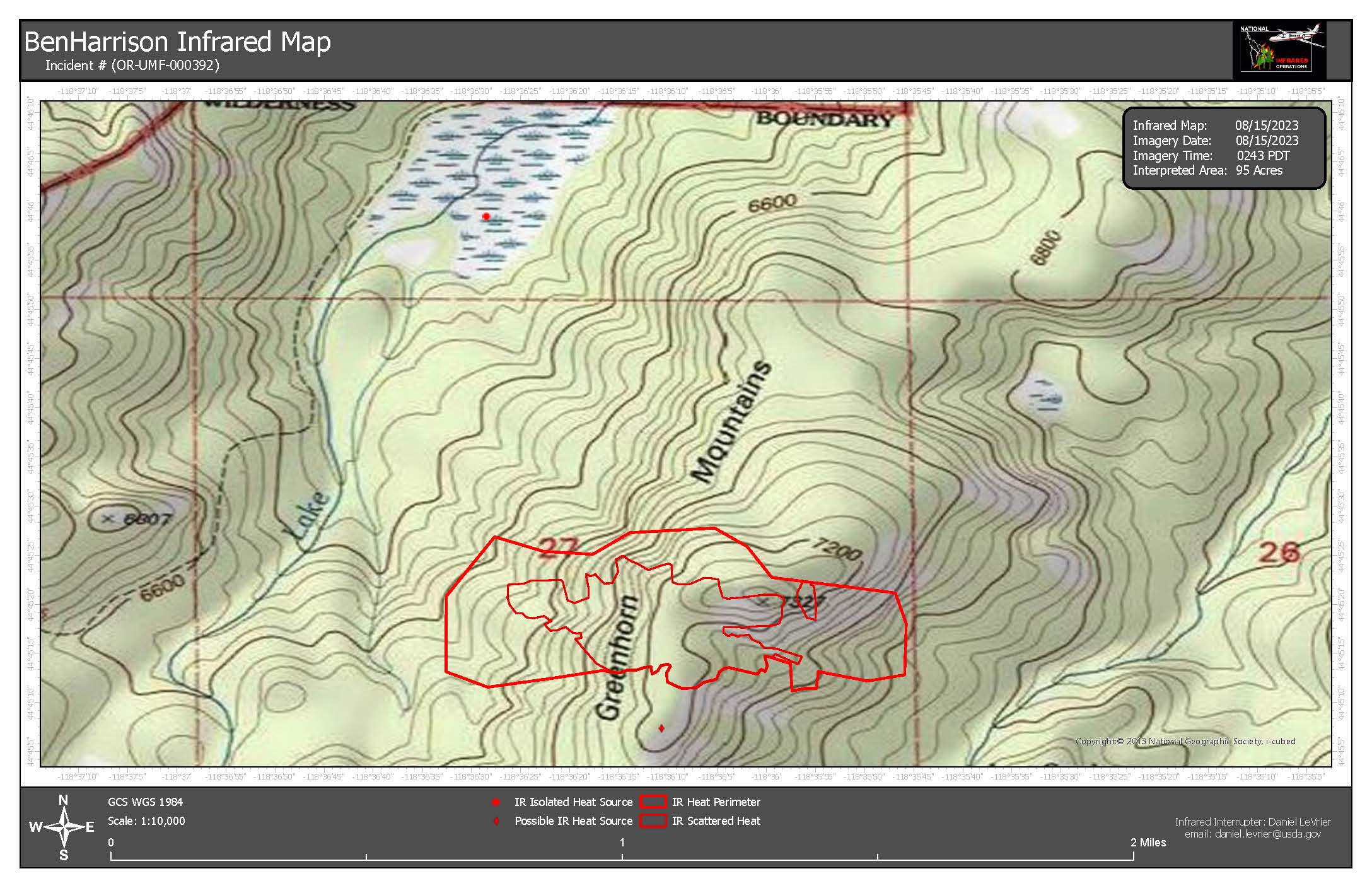
Ben Harrison Fire Final Update Aug 15 2023
Related Incident: Ben Harrison Fire
Publication Type: News
PENDLETON, Ore. (August 15, 2023 – 10 a.m.) — Firefighters have completed handline construction around the 95-acre Ben Harrison Fire, which is located approximately 20 miles west of Sumpter, Oregon on the North Fork John Day Ranger District. The fire is burning in sub alpine fir, which is known for holding on to heat that can reignite and produce embers that start spot fires. Because of this fire managers are keeping the containment at 0% until condition are more stable.
Fire behavior was minimal yesterday, primarily consisting of creeping and smoldering with larger fuels burning on the interior. Low fire behavior allowed firefighters to complete control lines around the perimeter of the fire. An infrared flight conducted last night showed the fire had interior scattered heat and a few isolated heat sources. The fire has not moved outside of the estimated perimeter in the last few days.
Today firefighters will continue to scout for spot fires while strengthening containment lines and conducting mop up operations. Mopping up includes searching for pockets of heat, digging out the heat source, and cooling with water. Resources assigned to the fire include 20 smoke jumpers, three handcrews, four rappellers, and local district personnel. Aircraft are available as needed. Based on operational needs as containment increases, fire managers will begin demobilizing resources over the next few days to be available to respond to other fires.
This will be the final daily update unless conditions change. Information regarding progress on the fire will be shared on the Umatilla National Forest Facebook page, Blue Mountain Fire Information Blog and Inciweb.
Olive Lake Campground remains temporarily closed. The campground is currently being utilized as the Incident Command Post for the Ben Harrison Fire. The Forest will reopen the campground once conditions moderate and suppression resources are moved out of the campground.
High pressure has built over the west this week. High temperatures across the Columbia Basin are expected to be 100 degrees or higher. Excessive Heat Warnings are in effect throughout the week. Fire officials want to remind everyone that the current fire danger rating remains at HIGH and public use restrictions involving chainsaw use, smoking and off-road travel are in effect.
For more information regarding Restrictions, please contact:
Umatilla National Forest:
Information Hotline: Toll-Free (877) 958-9663
www.facebook.com/UmatillaNF Twitter: @UmatillaNF
The latest fire information will be posted on the Blue Mountains Fire Information Blog. To receive updates on fires in the Blue Mountains, follow our blog at http://bluemountainfireinfo.blogspot.com/.
Additional information about the Umatilla National Forest is available at: http://www.fs.usda.gov/umatilla.
###
Pogo Mine Road 191 Mount Hayes 299 Fires Update 8152023
Related Incident: Pogo Mine Road FireMount Hayes Fire
Publication Type: News
WILDFIRE UPDATE - Delta Area - #pogomineroadfire (#191) & #mounthayesfire (#299)
Tuesday - August 15, 2023
The Airshow continues, Firefighters dig in
Another day of warm and dry weather in the Delta area led to an increase in fire behavior on both fires with noticeable smoke columns on the Pogo Mine Road Fire. A swift and steady response from air tankers and helicopters knocked down flare ups and kept the fire from spreading. Firefighters worked to secure control lines and provided structure protection with a load of smokejumpers joining the effort Monday evening.
Pogo Mine Road Fire (#191) – 47,179 acres | 96 personnel | 12 miles NW of Delta
The main area of growth occurred in the southwest corner of the fire near the Winter Trail. Fire Bosses, Super scoopers, retardant planes and helicopters targeted hot spots with a continuous bombardment. A load of smokejumpers from Fairbanks parachuted into the south flank to provide structure protection for cabins north of Quartz Lake close to the fire’s edge. Tongass Fire Suppression Module is working to secure hot spots directly along the Alyeska Pipeline. Tanana Chiefs Conference Crew is protecting structures and Arroyo Grande Hotshots are in place for both structure protection along Shaw Creek and to complete mop up near structures.
Mount Hayes Fire (#299) – 7,085 acres | 90 personnel | 7 miles SE of Deltana
This wildfire is being monitored by air with resources in place to hold and improve the north dozer lines. Fire activity has been minimal with creeping and smoldering. Firefighters, including the Sierra Hotshots, are getting the necessary supplies for protecting cabins and getting set up logistically for remote camping. The main focus is installing pumps, hoses and sprinklers for three public-use cabins east of the Gerstle River owned by Alaska Fish and Game.
Weather: A low pressure system moving into the Gulf of Alaska will increase winds slightly Tuesday night into Wednesday and bring some better chances for more widespread showers. Tuesday’s weather: Max temperature around 70 with low humidity at 45 percent and northwest winds 7 to 10 mph decreasing to light and variable.
A Temporary Flight Restriction is in place for the fires, pilots please check NOTAMs.
Fire Information: Phone number: 541-977-2756 / Fire Info website: AkFireInfo.com Facebook: AK.Forestry / Twitter: @AK_Forestry / YouTube: AlaskaDNRDOF
Black Feather Fire Daily Update August 15 2023
Related Incident: Black Feather Fire
Publication Type: News
Black Feather Fire Community Meeting Today, Tuesday, August 15, 2023
Acres: 2,198 acres
Start Date: August 5, 2023
Cause: Lightning
Fuels: Timber, Brush, Understory
Containment: 5%
Resources: 451 personnel
Location: Approximately 9 miles south of Gallina, NM, on the Santa Fe National Forest, Coyote Ranger District. Near the Peñas Negras Trail in the San Pedro Parks Wilderness.
Highlights: A community meeting will be held for the Black Feather Fire tonight, Tuesday, August 15, at 7 p.m. at the Coronado High School Campus at 1903 NM-96, Gallina, NM 87017. A live-stream of the meeting will be available on the Black Feather Fire Facebook Page https://www.facebook.com/blackfeatherfireinfo (no account is needed to view this live-stream).
Primary and alternate containment lines are in place around the Black Feather Fire, and fire managers are reporting 5% containment on the southeast side of the fire. Reported containment represents the location and percentage of line where fire managers believe it is unlikely the fire will spread. Because of the heavy dead standing and down timber in the wilderness, the Black Feather Fire is expected to continue to smolder and burn for an extended period of time. Current resources on the fire include 7 hotshot crews, 2 hand crews, 4 engines, 4 helicopters, 1 dozer, 4 water tenders, fix-wing aircraft, and an infrared drone providing firefighters with the ability to identify hot spots and more accurately map the impacted area.
Operations: Weather continues to moderate fire behavior and allow the on-site Incident Management Team to enhance their long-term response and protection plan for the area of the Black Feather Fire. Today, firefighters will continue reducing fuels and enhancing primary and secondary containment lines while utilizing the infrared drone and personnel on the ground to locate and mop up hot spots. Incident objectives for the Black Forest Fire include firefighter and public safety, protecting property, infrastructure, and other values at risk.
Evacuations: The communities of Mesa Pinebetal, Mesa Poleo, and Wetherill remain in ‘Ready’ status. The Coyote Senior Center is open to evacuees, and livestock can be taken to the Rio Arriba Rural Event Center near Abiquiu. The Rio Arriba County Sheriff’s Office is coordinating evacuations. For more information, use the QR code below and visit the Sheriff’s Office Facebook page: https://www.facebook.com/profile.php?id=100079688263048
Safety: Expect increased activity in the area and on local roads as firefighters and equipment move to new locations. Please stay out of the fire area to allow crews safe access to the fire. A Temporary Flight Restriction is in place around the fire area. Please do not fly drones anywhere near the fire. If you fly, we can’t fly.
Weather: Lingering showers and thunderstorms remain today, with the strongest storms being capable of producing heavy rain. A flood watch that includes the fire area has been issued for this afternoon and evening. Warmer temperatures are expected today, with a modest decrease in humidity.
Restrictions/Closures: The Santa Fe National Forest has issued an area, road, and trail closure in part of the Coyote Ranger District. See https://www.fs.usda.gov/alerts/santafe/alerts-notices/?aid=82412 for information and a corresponding map. Forest Road 103 is closed to non-residential traffic. Closures will be adjusted based on fire activity.
Smoke: Variations in temperatures and humidity in the coming days and weeks will impact smoke conditions. Smoke may be more and less visible in the area as active smoldering takes place. Smoke-sensitive individuals and people with respiratory problems or heart disease are encouraged to take precautionary measures. Air quality information is available at https://www.airnow.gov/
Fire Information: 505-460-0499 – 2023.blackfeather@firenet.gov
Facebook: https://www.facebook.com/blackfeatherfireinfo
New Mexico Fire Information: https://nmfireinfo.com/
8152023 Morning Update
Related Incident: Lookout Fire
Publication Type: News
Lookout Fire
August 15, 2023
Morning Update
Size: 2,720 acres
Start Date: August 5, 2023
Point of Origin: 3 miles North of McKenzie Bridge, OR
Cause: Lightning
Total personnel: 403
Resources: 9 Engines
9 crews
7 bulldozers
7 water tenders
4 helicopters
Structural Resources: 7 OSFM Task Forces
Current Situation: The fire has remained within primary control lines and stayed north of Forest Road 700. Firefighters started strategic firing operations from Forest Road 700 overnight to consume fuel between them and the fire, slowing fire spread. The fire backed down to Lookout Creek. Firefighters will use the creek as an anchor point to prevent fire spread.
Oregon State Fire Marshal (OSFM) resources began arriving on the Lookout Fire yesterday afternoon, integrating into operations and assisting with structural protection. The conflagration declared just after 6 p.m. on Sunday evening allowed the mobilization of additional task forces from around the state, as well as an OSFM Incident Management Team. OSFM Blue Team joined NW Team 6 in unified command Monday morning at 6 a.m. Task Forces currently assigned to the fire are from Clatsop, Tillamook, Lane, Clackamas, Deschutes, Yamhill, and Marion Counties. Structure crews have been establishing situational awareness, assessing structural access, and beginning surface preparations.
Today’s activities: Firefighters will continue preparation work on Forest Road 700, using heavy equipment to ensure the fire stays north of the road. Firefighters are scouting nearby roads to connect primary control lines. Aviation suppression resources will continue to be used to slow fire activity while crews work on the ground.
OSFM resources are working on the south end of the fire and working near homes on Taylor and North Bank doing triage and preparation, as well as assisting wildland resources.
COMMUNITY MEETING: Thursday, August 17, 2023, 6:30-7:30 p.m., In-person at McKenzie High School, 51187 Blue River Dr, Vida, OR 97488 and virtually on Facebook.
Evacuations: There are some Level 3 evacuations North of Highway 126. For current information please see Lane County’s website at: https://www.lanecountyor.gov/cms/one.aspx?pageId=19729054
Weather: A red flag warning is effect for the area for hot, dry and unstable conditions.
Closures: Willamette National Forest closures can be found at: https://www.fs.usda.gov/detail/willamette/alerts-notices/?cid=fseprd552029
Restrictions: Fire Restrictions are in place on the Willamette National Forest https://www.fs.usda.gov/willamette
Smoke: Smoke Forecast Outlooks are available at https://outlooks.wildlandfiresmoke.net/outlook
Gravel Pit Fire Daily Update Tuesday August 15 2023
Related Incident:
Publication Type: News
Gravel Pit Fire Daily Update
Montana Department of Natural Resources and Conservation, Northwest Land Office
WESTERN MONTANA ALL HAZARDS IMT │ INCIDENT COMMANDER: KEN PARKS
https://inciweb.wildfire.gov/incident-information/mtmts-gravel-pit-fire
2023.gravelpit@firenet.gov (406) 247-0514
Tuesday, August 15, 2023 at 10:00 a.m.
Location: 25 miles southeast of Libby, near Silver Butte
Start Date: 8/1/23 Cause: Human Size: 304 acres Containment: 72%
Total Personnel: 80 Engines: 7 Tenders: 1 Hand Crews: 2
SPECIAL WEATHER MESSAGE
The National Weather Service has issued a heat advisory from noon on Tuesday through midnight on Thursday in much of northwest Montana, including the fire area, with valley temperatures of 105°F possible.
CURRENT STATUS
Yesterday to the west, crews continued to mop-up and extinguish hot spots. Flare-ups, including burning brush and stumps, occurred within the fire perimeter in pockets of unburned flammable materials. Crews also continued to backhaul hose that is no longer needed. Additionally, crews continued to support fire suppression actions on two new fire starts from Sunday, one to the north and one to the south of the Gravel Pit Fire.
PLANNED ACTIONS
Crews that responded to the new fire start to the north of the Gravel Pit Fire on Sunday returned today and will continue with mop-up activities on the Gravel Pit Fire. The crew responding to the fire start to the south of the Gravel Pit Fire will continue suppressing that fire. On the Gravel Pit Fire, crews will continue to backhaul hose on lower and middle elevations and leave hose in place in the upper elevations where smoldering stumps and other combustible materials are continuing to flare-up. Crews will maintain readiness for initial attack and respond to new fire starts in the area.
WEATHER AND FIRE BEHAVIOR
High pressure, resulting in hot, dry conditions will persist through Thursday. Afternoon temperatures will be near record highs this week and overnight relative humidity recovery will be poor.
Fire behavior is low, with smoldering and creeping, but the potential exists for more active fire behavior with the hot, dry weather pattern over the next three days.
EVACUATIONS AND CLOSURES
Effective 8/14/2023, the evacuation warning in place for residents near the fire area along the Highway 2 corridor has been lifted. All Lincoln County residents are encouraged to sign up for emergency alerts by downloading the Code Red application and entering contact information. Code Red is the primary notification system to alert residents of evacuations.
Buckskin 2 Fire Update August 15 2023
Related Incident:
Publication Type: News
Buckskin 2 Fire
Idaho Panhandle National Forests, Sandpoint Ranger District
Fire Information: 208-557-8813
https://inciweb.nwcg.gov/incident-information/idipf-buckskin-2-fire
Type 3 Incident Commander, Brian Hicks
August 15, 2023
Location: Located approximately 8 miles due south of Clark Fork, ID on the upper end of Twin Creek and Buckskin Saddle, south of Highway 200
Start Date: 8/4/2023
Cause: Undetermined
Size: 264 acres
Containment: 15%
Total Personnel: 160
Engines: 8
Hand Crews: 5
Modules: 3
Heavy Equipment: 3 Dozers, 2 Skidgens, 1 Water Tender
Last night’s infrared flight mapped the fire at 264 acres and detected less heat signatures than the previous night. The hard work of firefighters on the ground with assistance from aerial firefighting resources has successfully reduced heat sources, even during the hottest and driest weather this summer. The fire remains in its footprint and is currently 15% contained. Pockets of unburned fuels within the perimeter of the fire will continue to be active and smoke may be visible at times.
Another crew arrived at the fire yesterday bringing the total to five 20-person hand crews; This includes one highly skilled Interagency Hotshot Crew. Additional engines and heavy equipment have arrived over the last couple of days as well. Aircraft continue to be a shared resource with other fires in the region but are available as needed.
Crews and heavy equipment continue to build and reinforce direct fireline along the western edge of the fire. Along the remaining perimeter, firefighters are improving, holding, and mopping up existing firelines. Hazardous tree removal continues around the fire.
EVACUATION STATUS
The Bonner County Sheriff’s Office issued a READY notification for the Twin Creek Rd and Rearden Rd residents in Clark Fork. To receive local status updates, sign up for Bonner County Sheriff’s Office emergency messaging through NIXLE at www.nixle.com.
CLOSURES AND SPECIAL MESSAGES
Forest Closure Order is in effect for roads associated with the Buckskin Fire; the intersection of Forest Service Roads 203 and 332, the intersection of FSR 1021 and 332, and 1533 and 306 in Clark Fork. UTV trail 77 is closed as well. An extension of the FSR 203 closure, extending to the edge of private land, is pending. The public is prohibited from the general area for firefighter safety and asked to practice caution while driving near firefighters and apparatuses.
Stage II Fire Restrictions are in effect. To view the Idaho Fire Restrictions Plan and a statewide map with current information regarding fire restrictions, please visit https://www.idl.idaho.gov/fire-management/fire-restrictions-finder.
A Temporary Flight Restriction is in place for the safety of our aerial resources and firefighters on the ground. This includes drones; please do not fly drones in the fire vicinity. If you fly, we can't.
WEATHER
The high-pressure system persists with hot and dry weather. Today, sunny with a high of 97 and west winds around 7 mph.
Anderson Complex Daily Fire Update for August 15 2023
Related Incident: Anderson Complex
Publication Type: News
Anderson Complex crews end threat to 60% of structures, allotments
At the end of yesterday’s shift firefighters assigned to the Anderson Complex had ended the threat to 60 percent of structures and allotments that were initially endangered by the fires in the complex. Crews are still taking steps to protect any structures or allotments that remain threatened by fire.
For the third consecutive day a Blackhawk helicopter was used yesterday to drop water on hotspots along the northern side of the Shores Landing Fire (#325). The fire continues to be most active during the afternoon but has not seen significant growth. Firefighters have created defensible space around one allotment northeast of the fire and are working today around a second allotment to protect it.
Crews in the area of the Teklanika River Fire (#257) are extinguishing smoldering vegetation and felling fire-damaged trees to reduce risk to firefighters and the public. They are maintaining structure protection measures where they are still needed; however, pumps, hoses, and sprinklers that are excess are being removed for return to the fire cache.
Firefighters in the Anderson-Nenana Group and Kobe-Birch Group are also disassembling pumps, hoses and sprinklers that are no longer needed so they can be returned to the cache for inspection, cleaning and any needed repairs. Firefighting equipment that is still needed to protect threatened structures is not being removed.
Crews in Anderson, the North Forties and Kobe Ag subdivisions are also engaged in suppression repair. Their goal is to reduce the potential impacts of firefighting efforts. Firefighters working in Rose Hip Creek and Clear Sky homestead continue to fell fire-damaged trees to reduce risks to firefighters and the public. They are also removing firefighting equipment that is no longer needed.
The Anderson Complex includes the Teklanika River Fire (#257), Birch Creek Fire (#285), Shores Landing Fire (#325), Rock Creek Fire (#287), Bear Creek Fire (#287), Kobe Road Fire (#297), Nenana River Fire (#288), and Nenana River 2 Fire (#289). The fires now have a combined acreage of 58,933 acres. The increase from the last reported acreage is due to more precise mapping based on satellite data and moderate fire activity over the past several days. The fires that saw a change in reported acres were the Rock Creek Fire (+7,702 acres); Shores Landing Fire (+269 acres); Teklanika River Fire (+135 acres) and Bear Creek Fire (+132 acres).
WEATHER: Today’s forecast calls for partly cloudy skies with a possibility of afternoon rain and thunderstorms. Temperatures have begun cooling off, which daytime highs expected to be in the low to mid 60s by the end of the week. Relative humidity is increasing. Fire activity is expected to be moderate to minimal under these conditions.
EVACUATIONS: The Teklanika River and all residents along the Teklanika River remain in evacuation status GO. Individuals in this area should evacuate now. Do not delay. The Tri-Valley School is available for evacuation parking and will be available as an evacuation center, if needed.
The Rose Hip Creek area and Clear Sky homestead are in evacuation status SET. Individuals in this area should be ready to evacuate at a moment’s notice if necessary. Those re-entering burned areas should be aware of possible hazards, including fire-damaged trees, ash pits, smoldering stumps or logs, and the potential for flash flooding. Firefighters will still be in the area. Please give them room to work.
The City of Anderson, the North Forties subdivision, and Kobe Ag subdivision are in evacuation status READY. Individuals in this area should remain ready for possible evacuation.
Visit the Denali Borough website for additional information.
CLOSURE: The City of Anderson has closed the shooting range until further notice for firefighter and public safety. Firefighters are working in the area for the next several days. The campground and playground are open.