
Black Feather Fire Daily Update August 16 2023
Related Incident: Black Feather Fire
Publication Type: News
Northern New Mexico Type 3 Incident Management Team to Resume Management of The Black Feather Fire
Acres: 2,198 acres
Start Date: August 5, 2023
Cause: Lightning
Fuels: Timber, Brush, Understory
Containment: 22%
Resources: 442 personnel
Location: Approximately 9 miles south of Gallina, NM, on the Santa Fe National Forest, Coyote Ranger District. Near the Peñas Negras Trail in the San Pedro Parks Wilderness.
Highlights: A strong strategic plan and favorable weather, combined with firefighting efforts, have allowed fire managers to begin a transition from The Southwest Area Incident Management Team 2 (SWAIMT2) back to The Northern New Mexico Type 3 Incident Management Team at 7:00 a.m. Thursday, August 17. Details on the activities and planning process were discussed in detail at the community meeting on August 15. A recording is available on the Black Feather Fire Facebook page: https://www.facebook.com/blackfeatherfireinfo (video begins at approximately the 5:30 minute mark, and no account is needed to view this recording).
Strengthening of primary and alternate containment lines led to an increase in containment. With the majority of the fire area located within the San Pedro Parks wilderness, fire behavior, including smoldering, occasional flare-ups, and periods of visible smoke, is expected. The approved plan being transferred to the new management team will continue to address those occurrences. Current resources on the fire include 7 hotshot crews, 2 hand crews, 4 engines, 4 helicopters, 1 dozer, 4 water tenders, 4 chippers, and an infrared drone providing firefighters with the ability to identify hot spots and more accurately map the impacted area.
Operations: The objectives of the long-term response and protection plan for the area of the Black Feather Fire remain. Today, firefighters will focus on suppression-repair efforts, including chipping along roadways and removing branches and brush, with the goal of leaving as soft of a footprint as possible. Infrared drone flights continue to be an asset in identifying hot spots, allowing firefighters to respond quickly and reduce the potential for additional growth.
Evacuations: The communities of Mesa Pinabetal, Mesa Poleo, and Wetherill remain in ‘Ready’ status. The Coyote Senior Center is open to evacuees, and livestock can be taken to the Rio Arriba Rural Event Center near Abiquiu. The Rio Arriba County Sheriff’s Office is coordinating evacuations. For more information, use the QR code below and visit the Sheriff’s Office Facebook page: https://www.facebook.com/profile.php?id=100079688263048
Safety: Expect increased personnel in the area and on local roads as firefighters and equipment move to new locations. Please stay out of the fire area to allow crews safe access to the fire. A Temporary Flight Restriction is in place around the fire area. Please do not fly drones anywhere near the fire. If you fly, we can’t fly.
Weather: A slow warming and drying trend continues today with slightly lower levels of moisture in place. Afternoon and evening rain showers, with heavy accumulation in the area, are possible.
Restrictions/Closures: The Santa Fe National Forest has issued an area, road, and trail closure in part of the Coyote Ranger District. See https://www.fs.usda.gov/alerts/santafe/alerts-notices/?aid=82412 for information and a corresponding map. Forest Road 103 is closed to non-residential traffic. Closures will be adjusted based on fire activity.
Smoke: Variations in temperatures and humidity in the coming days and weeks will impact smoke conditions. Smoke may be more and less visible in the area as active smoldering takes place. Smoke-sensitive individuals and people with respiratory problems or heart disease are encouraged to take precautionary measures. Air quality information is available at https://www.airnow.gov/
Fire Information: 505-460-0499 – 2023.blackfeather@firenet.gov
Facebook: https://www.facebook.com/blackfeatherfireinfo
New Mexico Fire Information: https://nmfireinfo.com/
Tin Soldier Complex Daily Update August 16
Related Incident:
Publication Type: News
Flathead National Forest Land Management
FLATHEAD INTERAGENCY TYPE 3 TEAM INCIDENT COMMANDER: MIKE WEST
Fire Information: 406-758-5314 Email: 2023.tinsoldiercomplex@firenet.gov
https://inciweb.nwcg.gov/incident-information/mtfnf-tin-soldier-complex
Wednesday, August 16, 2023, at 10:00 am
Location: 17 miles east of Swan Lake, Montana
Start Date: 7/30/2023 Cause: Lightning Size: 2,880 acres Containment: 0%
Total Personnel: 70 Engines: 2 Type 2 IA Crew: 2 Wildland Fire Module: 2
Note: Additional personnel from the Spotted Bear District are “on loan” and assisting with fire related operations. Priority will be given for initial attack if any other fires on the Spotted Bear District are detected.
SUMMARY
Last night a UAS (Unmanned Aerial Systems) drone flight above the fires found that the Kah Mountain and the Sullivan Fires grew in size and merged together. These fires will now be known as the Sullivan Fire. The Bruce Fire also had some increased activity into the Bruce Creek and Stony drainages.
An Infra-Red (IR) flight did not occur last night to map this increased growth; we will update this acreage as soon as we get a new IR flight.The Tin Soldier Complex is estimated at 2,880 acres in size and remains 0% contained. Estimated acres burned as of the morning of Wednesday, August 16th.
- Bruce Fire – 1034 acres at 0% containment
- Kah Mtn Fire – 557 acres at 0% containment
- Sullivan Fire – 1,289 acres at 0% containment
- Con Kelly Fire – 0.25 acres – Out.
Due to the hot and dry weather projected for the next few days, fire behavior is expected to increase across the complex. Smoke columns from the Tin Soldier Complex may be visible from the Flathead Valley.
Today’s actions will include ongoing structure protection efforts for the commercial guest ranches, Spotted Bear Ranger Station compound, Heinrude residential community, and other infrastructure in the area. Crews will continue fuels reduction, slash removal, structure prep, and daily testing of the sprinkler systems and water pumps for all values at risk. Mechanical equipment finished the fuel break to the north, south and west side of FS Road #895 adjacent to the Heinrude community. Structure protection for Spotted Bear Lookout is complete.
EVACUATIONS, CLOSURES AND RESTRICTIONS
Evacuations: An evacuation has been issued by the Flathead County Sheriff for Heinrude community.
Restrictions/Closures:
- Stage 2 fire restrictions are in effect as of August 5th.
- An area closure is in effect for the Hungry Horse Reservoir, the front country of the Spotted Bear district as well the Gorge Creek drainage within the Bob Marshall Wilderness area due to the Stadium Fire.
- A Temporary Flight Restriction is in place for air space over the Tin Soldier Complex to provide a safe environment for fire aircraft operating in the area. This includes the Spotted Bear and Meadow Creek Airstrips! Remember that temporary flight restrictions also apply to UAS or drones. If you fly, we can’t!
Today’s weather is expected to be mostly sunny with hazy conditions in the afternoon. Temperatures are expected to be in the mid to high 90s, with winds out of the Southwest 5-8 MPH changing to West 10-13 MPH this afternoon. Critical fire weather concerns have prompted a Fire Weather Watch for the area on Thursday due to the combination of hot, dry, and windy conditions.
Little Mesa Fire Update August 16 2023
Related Incident: Little Mesa Fire
Publication Type: News
Little Mesa Fire Update
Wednesday, August 16, 2023
Location: Approx. 15 miles west, southwest of Delta, CO, Dominguez Escalante National Conservation Area
Discovered: July 31, 2023, 11:00 AM
Cause: Lightning
Estimated Size: 3,483 acres
Vegetation Type: Pinyon, Juniper, sagebrush, grass
Containment: 10%
Total Personnel: 73
NOTICE TO THE PUBLIC: Air operations are being conducted on the Little Mesa Fire. For your safety, please stay out of the Potholes Recreation Area. The helicopters are using this water source for fire suppression.
Current Situation: Yesterday, firefighters made great progress continuing to secure the fire perimeter from Tatum Ridge Road, Dry Mesa to Black Point Road. The fire had no real growth, but due to better mapping the map shows an increase in acreage. A fire crew used hand ignitions to add more depth to assist in securing the perimeter. Rain showers bypassed the fire area yesterday.
Today, fire crews will continue to secure the fire perimeter in hopes of increasing containment in coming days. Hand ignitions will also continue within the perimeter to clean up areas of unburned vegetation missed by aerial ignitions. This effort will assist in decomposition of woody material for resource benefit. Suppression repair will be started with the use of an excavator to repair mastication lines and to close previously closed roads with large natural material. Crews will repair hand line and fences, along with starting to seed burn area.
Weather: High pressure remains overhead today with subtropical moisture in place, resulting in another day of potential afternoon showers and storms primarily on the southern end of the fire. Potential for heavier rain and frequent lightning with gusty outflow winds are the primary concerns. Temperatures will remain in the lower 80s with 8 to 12 mph winds from the southwest. In coming days, the flow shifts to the south, resulting in a more favorable monsoon pattern to pull the moisture north.
Evacuations and Closures: No evacuations have been issued. Temporary road closures in Delta County on Dry Mesa Rd at the intersection with Escalante Rim Rd and on USFS Dry Mesa Rd at Sawmill Mesa Rd junction. The GMUG National Forests have issued a forest closure order for the area around the Little Mesa Fire. Public access to the closure area is limited, visit https://bit.ly/3YwXNz0 for more information.
Smoke: Smoke is visible from surrounding areas and Highways 50, 550, 92, 65, 141 and C37 Road. Go to fire.airnow.gov or colorado.gov/airquality/ to get updates on smoke conditions.
Aviation Safety: Incident aircraft may be flying over the Little Mesa Fire air space. Fire aviation resources are flying at different altitudes and speeds. Unmanned aircraft systems (UAS) or drones must never fly near wildfires. The only UAS or drones able to fly are agency owned and operated, which have been assigned to work on the wildfire and have communication with air operations. Remember if you fly, we can’t!
For updated information follow on these outlets:
Inciweb: https://inciweb.wildfire.gov/incident-information/coupd-little-mesa-fire
Facebook: @LittleMesaFire Twitter: @SWD_Fire
Flat Fire Update 08162023
Related Incident: Flat Fire
Publication Type: News
August 16, 2023
Flat Fire Morning Update
Start Date: July 15, 2023 Total personnel : 536
Size: 33,895 acres Containment: 58%
Resources: 22 engines l 9 crews l 3 bulldozers l 20 water tenders l 9 masticators l 4 helicopters
Current Situation: With the increased temperatures and dry conditions, firefighters continue to utilize aviation resources to monitor the scattered hot spots. Fire activity is limited to small, isolated pockets inside the fire perimeter. Fire behavior for today is expected to remain the same with scattered areas of smoldering and creeping and occasional flare-ups with single tree torching. Crews continue to be vigilant with frequent localized weather observations and careful monitoring of ridge tops, drainages, unburned islands, and isolated heat sources. Warmer morning temperatures have created an increase of smoke in some areas. Some drift smoke may also appear from other wildfires across the region. Resources assigned to the Flat Fire continue to assist with initial attack in the area as well.
Today’s activities: All resources are in place, patrolling contained fire lines, monitoring for fire behavior changes, and utilizing both heavy equipment and hand crews for contingency work. Some resources will continue to be available for initial attack as well as assisting with the O’Brien Creek Fire and new starts to the south in Six Rivers National Forest. Air resources will continue to monitor the fire and will also remain available to support initial attack efforts if needed. The Southwest Team 3 will begin to arrive today and tomorrow, anticipating a transfer of command on Friday morning. The objectives for suppressing this fire remain the same and firefighters will continue working towards full containment of the Flat Fire.
Weather: Today’s forecast calls for temperatures a few degrees warmer than yesterday and slightly drier. An Excessive Heat Warning remains in effect for portions of the Flat Fire through Thursday but a cooling trend is shaping up for the area starting on Friday and continuing through the weekend.
Smoke: The Smoke Outlook is available at: https://outlooks.wildlandfiresmoke.net/outlook/b74901f7?
Closures: Closure orders for the fire area can be found at: https://bit.ly/RRSNFAlerts
Evacuations: Level 1 “Get Ready” evacuation status in place for areas in the vicinity of the Flat Fire. Link to more
information: https://tinyurl.com/currycountyem
Restrictions: Fire danger is currently extreme; the Rogue River-Siskiyou National Forest will be moving into Stage 3 Public Use Restrictions (PURs) and IFPL Level 3 starting at 12:01 a.m. on Wednesday, August 16, 2023. Stage 3 PURs do not allow campfires anywhere on the forest, including developed recreation sites. IFPL Level 3 is a partial shutdown allowing the use of mechanized equipment only between the hours of 8 p.m. and 1 p.m. The Bureau of Land Management Medford District, Rogue River-Siskiyou National Forest and Oregon Department of Forestry Southwest Oregon District have also increased campfire restrictions on those lands located within the boundaries of the Wild section of the Rogue National Wild and Scenic River. The Wild section flows from Grave Creek to the mouth of Watson Creek. More information here: https://bit.ly/RRSNFAlerts
Please follow all fire restrictions to prevent wildfires. Know before you go. Check on whether there are any campfire restrictions at your recreation destination.
Fire Information:(541)216-4579
Facebook: facebook.com/flatfireoregon2023
Media inquiries: (541)237-6369
Twitter: twitter.com/FlatFireOR2023
Email: 2023.flat.or@firenet.gov
Inciweb: bit.ly/FlatFireOR
Ridge Fire Update for August 16 2023
Related Incident:
Publication Type: News
Ridge Fire Daily Update for August 16, 2023
Fire Information: 406-998-6074
Hours: 8:00 AM – 7:00 PM
Email: 2023.ridge@firenet.gov
Incident Website: http://inciweb.wildfire.gov/incident.../mtfnf-ridge-fire
Location: 6 miles southeast of Hungry Horse
Size: 3249 acres
Percent Contained: 14 %
Cause: Lightning
Start Date: July 30, 2023, 3:45 PM
Vegetation: Timber (Litter and Understory), Tall Grass, and Brush
Number of Personnel Assigned: 485
CURRENT SITUATION:
Yesterday, increased fire behavior on the Ridge fire and Doris Point fire was noticeably visible, producing a large smoke plume. Expect potentially similar conditions to continue with the hot and dry weather continuing into the weekend. The Ridge fire did not have significant fire growth and the containment lines held strong. Crews continued to make good progress on the direct handline and mop up on the south, west and north high priority areas of the fire. Aircraft is continuing to work on the eastern edge utilizing precision water drops to slow the fire progress to the east.
Today Crews will continue to secure the direct handline on the entire western half of the fire. Resources will start being shifted and redeployed to the eastern portion of the fire as the western portions are completed. Aircraft will work in conjunction with crews to attack the fire on the east side. California Incident Management Team 4 will take command of the Doris Point fire starting at 6:00 AM today, 8/16.
The Doris Point Fire, which started on July 30 by lightning is located on the west side of Hungry Horse Reservoir, is estimated at 763 acres, and burning within the current area closure. Due to the very hot and dry weather, fire behavior is increasing, and smoke columns are visible from Colombia Falls to West Glacier. The Doris point fire is a confine and contain strategy to support the Flathead National Forest resource management objectives and to provide point protection for campground infrastructure. There are no values at risk or threatened infrastructure at this time.
WEATHER:
Today’s weather is forecast to be mostly sunny with a maximum temperature of 92 degrees, minimum relative humidity of 20% at lower elevations, with winds being light and terrain driven. The hot and dry trend will stay until the end of this week.
CLOSURES:
The Hungry Horse Reservoir is closed to all public access, including both the east and west side roads. As firefighting efforts continue on the Ridge Fire, the Tin Soldier Complex, and other fires in the area, the closure is in place to provide for public and firefighter safety. https://www.fs.usda.gov/alerts/flathead/alerts-notices/?aid=82283
PRE-EVACUATION NOTICE:
The Flathead County Sheriff’s Office has issued a pre-evacuation notice from the east side of Spotted Bear Road to West Glacier. https://www.facebook.com/flatheadsheriff
EMERGENCY SHELTER:
The American Red Cross has identified the following location as an emergency shelter for residents affected by the Ridge Fire. Those who plan to use the emergency shelter are asked to call 1-800-733-2767 prior to your arrival.
Columbia Falls Junior High School, 1805 Talbot Road Columbia Falls, MT https://www.facebook.com/FlatheadOES
ADDITIONAL INFORMATION:
Residents should stay alert for changing conditions and visit ready.gov/wildfires for preparing for wildfires. Please refer to http://inciweb.wildfire.gov/incident-information/mtfnf-tin-soldier-complex for the Tin Soldier Complex Incident information.
August 16 2023 Colt Fire Daily Update
Related Incident:
Publication Type: News
NORTHERN ROCKIES TEAM 5 INCIDENT COMMANDER: JOE SAMPSON
CURRENT STATUS
The crews continued wood chipping along the eastern and southern sides of the fire. Crews removed hose lays and pumps around Beaver Lake and readied them for backhaul. Mop-up continued throughout the fire area with emphasis on cooling the remaining heat in heavy and dead fuels along the fire’s perimeter. A helicopter assisted ground crews by providing water bucket drops along the southern edge of the fire.
Air Operations updated the temporary flight restriction (TFR) over the fire area last night. The new TFR is smaller in size. The east boundary will now run roughly parallel to Highway 83, providing a corridor between the Swan Mountains and the fire area. The southern line will also move north near Marshall Creek and Lake Inez. The updated TFR also lowered the TFR ceiling from 11,500 to 9,500 feet. The updated TFR will still be in effect 24 hours a day due to continued night operations with the unmanned aerial system (UAS, i.e., “drone”) conducting infrared flights looking for “hot spots” along the lines.
PLANNED ACTION
Crews will continue to remove hose lays and pumps from the Beaver Lake area, where they are no longer needed. UAS operations will continue their detection of hot spots inside and outside the fire perimeter. Crews will mop-up residual heat along the fire’s perimeter through the fire area. Along the fire’s eastern and southern edge, chipping operations will continue.
WEATHER AND FIRE BEHAVIOR
Hot temperatures with very low relative humidity will continue during the burning period. Windspeeds will not be as gusty as predicted so the Fire Weather Watch is cancelled for today but is still in effect for tomorrow. Expect single tree and/or group torching to occur throughout the fire area. The fire incident’s meteorologist released another weather balloon yesterday. Data from the balloon showed winds from the east which led to the increase of smoke seen from the Big Knife Fire in Arlee over the Colt Lake Fire area.
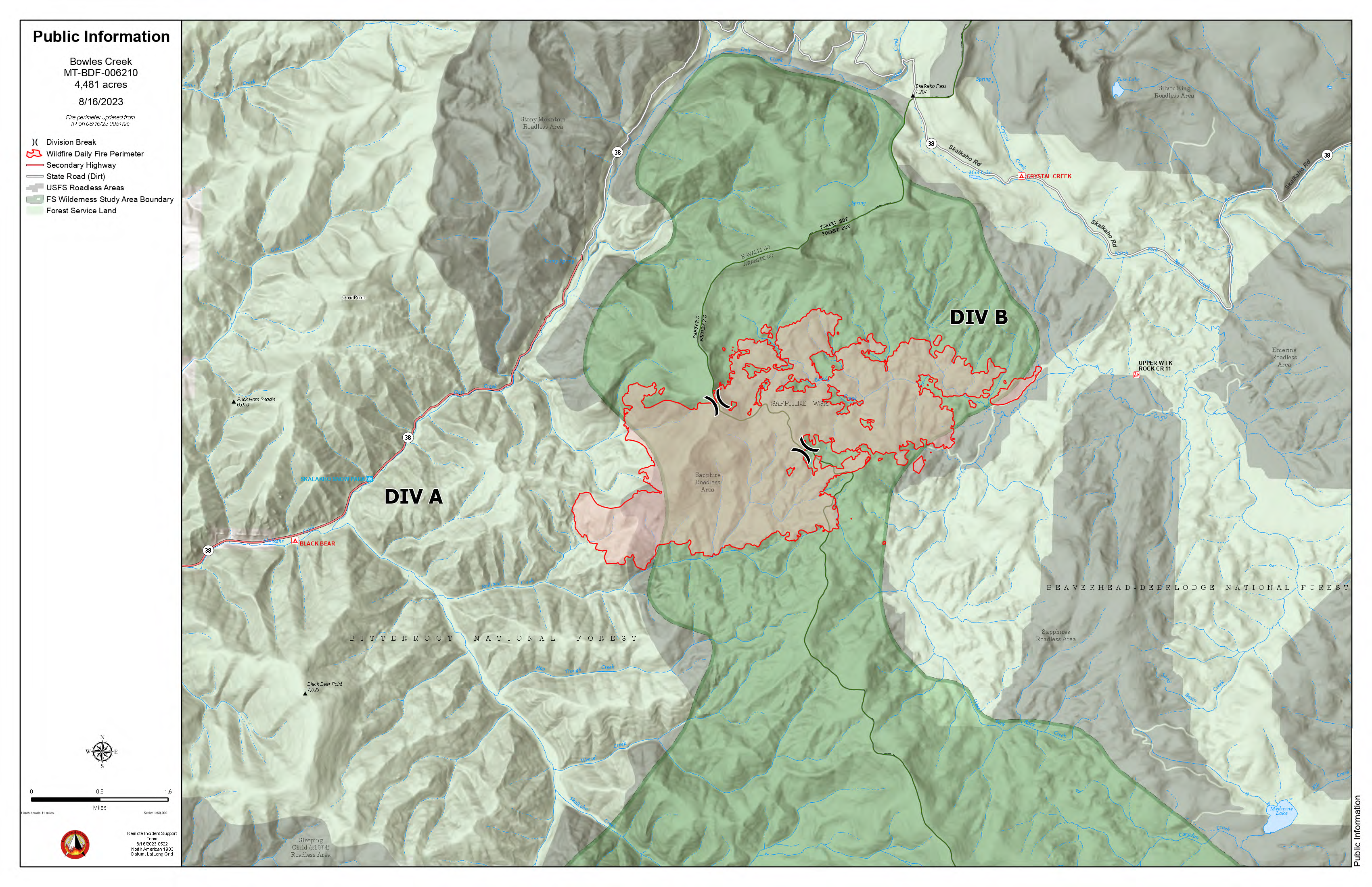
Bowles Creek Fire Update August 16 2023
Related Incident: Bowles Creek Fire
Publication Type: News
Highway 38, Skalkaho Road, remains open to the public. However, continued smoke impacts and fire operations may impact travel along the roadway, especially at night when visibility will be even further reduced. Motorists should exercise extreme caution while driving. The public is urged to travel along Highway 38 with caution and check for updated information in case of potential travel restrictions and closures as fire activity is expected to increase over the next several days. The rest of this week is forecasted to be warmer and drier, which may cause increased smoke levels and reduced visibility.
Fire crews continue to construct fuel breaks along several roads near the fire area. Fire behavior is being monitored and aircraft is checking fire spread. Firing operations are being used to strengthen containment lines as fire progresses. Fire crews also continue to implement chipping and mastication operations to reduce available fuels near values at risk.
The area is experiencing its 8th day of drying conditions, which now match the same conditions when the Bowles Creek Fire made its initial run at the end of July. Larger fuels are also beginning to dry with more live surface fuels becoming available. Fire activity is picking up, flanking and group tree torching is being observed. Overnight inversions have allowed for warmer nighttime temperatures and lower relative humidity levels, increasing the potential for increased fire perimeter growth.
Thompson Ridge Fire Update Aug 16 2023
Related Incident: Thompson Ridge Fire
Publication Type: News
Thompson Ridge Fire Update
Wednesday, August, 16, 2023
FIRE SITUATION
Varying amounts of rain, ranging from a light mist to occasional heavy rain fall, fell over much of the Thompson Ridge Fire on Tuesday. While this can decrease heat and fire potential, it can also increase dangers for the firefighters. For portions of the day, during the heavy rain, crews are taken off the fireline to mitigate any risk such as falls or lightning strikes.
Firefighters on the northeast corner will be utilizing an Unmanned Aircraft System (UAS) today to identify and put out remaining heat sources. With the minimized fire activity in the area, some crews were relocated to the southern perimeter to assist building of the indirect fireline. Progress has been made across this southern edge, and firefighters will continue this work for the next few days until a solid fuel break is complete. Direct attack still remains inaccessible on the northwest side of the fire. Crews continue to create a firebreak along the north fork of the South Creek Drainage. This will take multiple days to complete; more if hindered by continued rain. There is still smoke visible on the interior near the edge, as the large fuels retain the heat.
Two community meetings were held this week, and the Great Basin Team appreciates the members of the public, cooperators, and local officials that attended and assisted in making these events successful. An infrared flight was received over the fire which resulted in more accurate mapping and reduction of the estimated fire size by two acres.
EVACUATIONS: None at this time.
CLOSURES: Please refer to closure order. Please note that SR-153, Kent’s Lake Road (137), Upper and Lower Kent’s Lake, Little Res. Campground, Anderson Meadow, and LeBaron remain open at this time. Use caution in and around these areas, as you will see an influx of both ground and aviation equipment working to suppress the fire.
STATUS
Start Date: August 4, 2023
Incident Type: Wildfire
Size: 7,287 acres
Cause: Lightning
Containment: 15%
Location: 10 miles southeast of Beaver, Utah
Terrain: Steep, rugged terrain in remote areas transitioning to rolling pinyon juniper hills
Structures Threatened: None
RESOURCES
Engines: 9
Water Tenders: 2
Crews: 12
Helicopters: 6
Dozers: 1
Total Personnel: 461
Settings - change map background and toggle additional layers
Filter - control incident types displayed on map.
Zoom to your location
Reset map zoom and position
Could not determine your location.
Show Legend
 Wildfire
 Prescribed Fire
 Burned Area
Response
Burned Area
Response Other
Other
2023 - York Fire Burned Area Emergency Response (BAER)
Unit Information
Incident Contacts
Quartz Ridge Daily Update Wednesday August 16
Related Incident: Quartz Ridge Fire
Publication Type: News
Quartz Ridge Fire
August 16, 2023
Fire start date: August 5, 2023
Cause: Lightning
Location: 13 miles Northeast of Pagosa Springs, Colorado
Incident Commander: Jay Kurth
Management Team: NIMO Team 1
Management: Suppression
Fire size today: 1,440 acres
Containment: 0%
Personnel: 103
Evacuation Information:
There are no current evacuations. Local residents should follow incident information for updates.
Closures: tinyurl.com/mpt9jeds
- Quartz Meadows Rd (NFSR#685)
- Quartz Ridge Trail (NFST#570)
- Quartz Creek Trail (NFST#571)
Latest Smoke Outlook: https://outlooks.wildlandfiresmoke. net/outlook/933fc4e4
INCIDENT OBJECTIVES:
- Firefighter and Public safety are the highest priority.
- Protect private lands within East Fork San Juan River drainage, natural resources, cultural and historic sites, recreation assets, and critical infrastructure including powerlines and gas utility lines.
The wildfire is burning in steep terrain in the South San Juan Wilderness. Indirect suppression tactics are the safest approach since significant (almost 90%) tree mortality exists which creates a potential for burning and falling trees.
A Multi-Mission Aircraft flight indicated there was no new growth to the wildfire. The southeast corner of this fire is showing a reduction in the heat, while the west and north sections are showing a slight increase of heat. The three spot fires on the northeast side of Quartz Creek are showing less and less heat and are producing minimal smoke. Over the next week we will see the fire slowly start to become a little more active and see more smoke.
YESTERDAY’S ACCOMPLISHMENTS:
- Worked along East Fork Road to reduce fuels.
- Continued to evaluate terrain and potential areas for containment outside of wilderness boundaries and scout for strategic areas for control.
TODAY’S PLAN:
- Continue to use mechanized equipment along East Fork Road to improve proposed strategic control lines. A chipper will be used to assist with removed trees and fuel along these roads.
- Continue with suppression tactic reviews, with the objective of keeping the fire south of East Fork Road.
- Continue to improve the contingency line on the East Fork Road to the north and east of the fire.
- Crews will be hiking in on trails to start work of widening the trails and reducing fuel load.
- Continue to build structure protection plans both logistically and operationally.
WEATHER: Moisture chances will reduce throughout the week. Will see an uptick in temperatures, possibly into the mid-80s by the end of the week. The humidity and wind levels may pick up in afternoons, but not reach red flag wind warning levels
Incident Information : https://tinyurl.com/mr37bhnr
Facebook : https://tinyurl.com/y87cycm4
Email : 2023.quartzridge@firenet.gov
Information Line : 970-426-5370